
Saarland


.png)
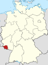
The Saarland [ ˈzaːɐ̯lantʰ ] ( French Sarre , abbreviation SL ) is a country in the southwest of the Federal Republic of Germany . The smallest of the territorial states and in terms of population with almost one million the second smallest state (after Bremen ) borders in the north and east on the state of Rhineland-Palatinate , in the south on the French region Grand Est , there on the Moselle department , and in the west the Grand Duchy of Luxembourg . Together with these neighbors and the Belgian region of Wallonia , the Saarland forms the greater European region of Saar-Lor-Lux . The state capital, largest city and the only regional center of Saarland is Saarbrücken .
After administrative and constitutional pre-forms since the 7th century ( Franconian Gaugrafschaft Saargau ) and the 17th century ( Duchy of Saarland , Saar province and Saar department ), the Saarland emerged in 1920 as a political unit (at that time still as the " Saar area " within smaller boundaries, the Northern border was further south) as a result of the Treaty of Versailles . It was spun off from the German Reich and existed as a League of Nations mandate for 15 years , until it was reintegrated into the German Reich , at that time under National Socialist leadership, in 1935 after the Saar referendum provided for in the treaty, with around 90 percent approval . After the Second World War , the Saarland became part of the French occupation zone . France spun it off and removed it from the jurisdiction of the Allied Control Council . A separate Saar government and the adoption of a Saarland constitution on November 8, 1947 were intended to create a formally independent (autonomous) state structure, which the Saarlanders called the Saar state. After another referendum in 1955 , however, Saarland joined the Federal Republic politically in 1957 ("small reunification"). The economic connection through the takeover of the D-Mark (popularly "Day X") took place on July 6, 1959.
geography
location
The Saarland is located in the extreme southwest of Germany . It extends over parts of the Hunsrück with the Black Forest high forest , the Lorraine layer level country and the Saar-Nahe mountainous country . With its expansion to 2,569.69 square kilometers, it has established itself in the German-speaking area as a benchmark for medium-sized catastrophic events such as forest fires or floods. Other important areas are Saargau and Bliesgau with their fertile limestone soils .
geology
The Saarland has a high geological and geomorphological heterogeneity. The Saarbrücker Saddle, which is located from northeast to southwest and in which carbonic rocks rise to the surface, connects to the north and northeast of sedimentary and igneous rocks of the Permian . These Permian rocks are bordered by the Hunsrück in the north, which forms the southern edge zone of the Rhenish Slate Mountains . In the northeast, the Permian rocks border the Mainz Basin , a lateral extension of the tectonically formed Upper Rhine Plain . The Saarbrücker Sattel is bordered in the south, south-east and west by Triassic rocks that are unevenly stacked to one another . Deposits from the Triassic fill the Saargemünd-Zweibrücker Mulde in the southeast of Saarland. They merge to the southeast into the red sandstone mountains of the Vosges and to the east into the Palatinate Forest . In the west and south-west of the Triassic regions of the Saarland there are deposits of the Paris Basin from the younger Mesozoic .
Surveys
The highest elevation is the Dollberg (695.4 m) north of Nonnweiler , the second highest is the Schimmelkopf (694.8 m) north of Weiskirchen . Significant elevation is however - probably from his tradition of the former as the highest mountain Saar out - as the mountain of the Saarland applicable Schaumberg in Tholey with its observation tower. At 569 meters, it is relatively low, but stands alone from a rather flat environment.
vegetation
A third of the area of the Saarland is covered with deciduous mixed forest. This means that Saarland, together with Hesse and Rhineland-Palatinate, has the largest percentage of forest area in Germany. In addition, the deciduous forest here takes up the largest proportion of the total forest area compared to all other federal states.
Waters
The longest river in Saarland is the Blies , of whose 99.5 km course, about 93 km are in the state, while the course of the Saar , which gives it its name , is only 68 km. The Blies rises in the northern Saarland near Selbach and flows into the Saar in the south as a border river near Saargemünd (France). Other important rivers are the Moselle , Prims , Nied , Nahe and Rossel . In the north there are also the Bostalsee and Losheim reservoirs.
Almost 95% of the area of the Saarland belongs to the catchment area of the Saar-Moselle river system. The remaining 5% of the land area in the northeast belonged to the Glan - Nahe drainage area.
Climate and precipitation
The climate is temperate oceanic . The annual rainfall averages 800 millimeters . The Saarland is one of the warmest regions in Germany.
Landscapes

In addition to the political structure in municipalities and in the rural districts of the Saarland , the following landscapes and areas can be described. They are characterized by a relatively uniform appearance in contrast to neighboring landscapes and areas, which is often the result of common political, historical or economic connections (especially agriculture , industrialization ):
- Bliesgau
- Köllertal
- Easter Valley
- Saargau
- Saar coal forest
- Black Forest high forest
- Sankt Ingbert-Kirkeler forest area
- St. Ingbert Valley
- Sankt Wendeler Land
- Warns
history


Today's Saarland was formed as a political unit on January 10, 1920 from areas that had belonged to the Prussian and Bavarian state territory since the Congress of Vienna , following administrative and constitutional forms in the Early Middle Ages and the Early Modern Age .
After the Second World War and before the state of Rhineland-Palatinate was founded on August 30, 1946, 142 communities with almost 900 square kilometers and around 100,000 inhabitants were separated from the Trier administrative district and incorporated into the Saarland on August 1, 1946 , making the Saarland territory up to in the Hunsrück and the Moselle . Just under a year later, on June 8, 1947, the French government had to take into account the resistance of the governments of the USA and Great Britain against this unilaterally implemented change of area and return 61 municipalities in the Saarburg and Trier districts . In the Saarland, however, areas of the expansion of August 1, 1946 in the northeast remained, which in the 19th century had been part of the Grand Duchy of Oldenburg ( exclave Principality of Birkenfeld ) and the Duchy of Saxe-Coburg and Gotha ( Principality of Lichtenberg ), as well as the border area to the Grand Duchy of Luxembourg in the north-west. In addition, the Saarland national territory was expanded on June 8, 1947 in the northeast by 13 Rhineland-Palatinate communities. On April 23, 1949, small areas of Rhineland-Palatinate were added to the east of Saarland.
In the time before the French Revolution , the four most important rulers in what is now Saarland were the Electorate of Trier , the Duchy of Lorraine , the Wittelsbach Duchy of Pfalz-Zweibrücken and the County of Saarbrücken . These four rulers are also reflected in today's state coat of arms.
The territories in what is now Saarland, which were independent prior to the French Revolution, had always been German-speaking since the early Middle Ages, but were repeatedly under French influence, especially in the late 17th century during the French reunions and in the period between the coalition wars and the Second Parisian Peace .
Even after the First World War and the Second World War, the country was under French influence. From 1920 to 1935 the " Saar area " (that was the name at the time) was under the administration of the League of Nations , but belonged to the French economic area. On March 1, 1935, after a referendum , initially under the name Saarland , the Saar area became part of the German Reich again.
After the Second World War, Saarland initially belonged to the French occupation zone , before it was removed from the area of responsibility of the Allied Control Council in January 1946 . In 1947 its own constitution and citizenship were created. On June 16, 1947 , the Saarland briefly received its own currency , the Saar mark, for monetary policy reasons . It was replaced by the French franc on November 20, 1947 . Own coins with German inscriptions and Saarland-related motifs were also minted, but were denominated in French francs ( see illustration ). The Saarlanders once again held a special position for over a decade. This time they also took part with their own teams in the 1952 Summer Olympics and in qualifying for the 1954 World Cup.
On October 23, 1955, a referendum on the Europeanization of the Saarland was carried out, in which 67.7 percent of the Saarlanders who voted said “No” and thus spoke out against the (second) Saar Statute negotiated by the Adenauer government with the French government . The result of the vote was interpreted as the will of the Saarland population to join the Federal Republic of Germany. The French government gave in, and on October 27, 1956, the Saar Treaty was concluded in Luxembourg , whereupon the Saarland became the tenth federal state of the Federal Republic of Germany on January 1, 1957. The economic affiliation including the takeover of the D-Mark was completed on July 6, 1959, the so-called "Day X".
population
During industrialization in the 19th century, a congestion area formed at the sites of coal extraction and steel production along the Dillingen – Saarbrücken – Neunkirchen line . The rural outskirts of the country have a lower population density.
language
Dialects
In Saarland, Rhine and Moselle Franconian dialects are spoken, which are usually called Platt by the speakers . Characteristic features of both dialect families ( closely related to each other and to the Luxembourgish language ) are poor diphthongs , systematic monophthongization , internal German consonant weakening and simplification of the word suffixes . The border between the Moselle and Rhenish Franconian dialects is the dat-das-line , which runs across the Saarland. It is not uncommon for Saarlanders to mix several dialects together.
German and French
The official language is German . French is occasionally heard in the Saarland because of its proximity to the border and is intended to serve as a kind of lingua franca to promote multilingualism in the region. The cities of Saarlouis and Saarbrücken also reach border areas in France with cultural or commercial offers. The stop announcements on the Saarbahn crossing the border are in German and French. Saarland is the only German federal state that requires French as a compulsory foreign language at grammar schools. The Saarland state government is planning measures to make French the second lingua franca by 2030.
Population development
Historical

The population of the region experienced two major growth and immigration spurts in modern times. The first concerns the late 17th and early 18th centuries. During the Thirty Years' War , which lasted in Lorraine until 1661 ( Peace of Vincennes ) and was continued almost seamlessly by the wars of Louis XIV , large swathes of land were deserted in the second third of the 17th century. The population loss for some territories is estimated at around 80 percent. A targeted immigration and settlement policy was used to recruit new citizens, including Huguenots , Walloons , Picards , Tyroleans and Swiss .
The region experienced the second surge in the 19th century. While industrialization began only hesitantly in the early 19th century, the population increased sharply after the Franco-Prussian War of 1870/71: The population of the greater Saarbrücken region quadrupled in the second half of the 19th century. The main areas of migration were the highly rural regions of the high forest and the Hunsrück, north of the industrialized areas . As a result, the majority of the population in the former Protestant areas of the County of Saarbrücken is now Catholic (62 percent of the population are Catholic and 19 percent Protestant; Saarland thus has the largest percentage of Catholic population in Germany). At the same time, the Saarland steel and smelter barons and the Prussian mine administration ensured that the workers and miners were able to acquire real estate and houses on favorable terms, which is why Saarland has the highest rate of property ownership in the country to this day.
The population development in the area of today's Saarland since 1924:
|
|
|
|
Current
For some time now, Saarland has been struggling with a significant decline in population. In 2006 the population fell by 0.68%. The main cause is an unfavorable natural population balance of −0.48% (birth rate per 1000: 6.9; death rate: 11.7). In 2006 the Saarland achieved a fertility rate of 1.233. This is last among the territorial states, only the fertility of Hamburg is even lower. In 2017 it was 1.51 children and was the third lowest among the federal states and the last among the large states. The population density of the Saarland is, however, still significantly higher than the national average. In the course of 2011, the population of the Saarland fell below the 1 million mark for the first time since 1955.
forecast
.svg)
| date | Residents |
|---|---|
| December 31, 2015 | 988.270 |
| December 31, 2020 | 960.150 |
| December 31, 2025 | 932.360 |
| December 31, 2030 | 904.520 |
Source: Bertelsmann Foundation
health
The average life expectancy in the period 2015/17 was 77.5 years for men and 82.2 years for women. The men are 12th among the German federal states, while women are 16th. Both values are thus below the national average. Regionally, in 2013/15 the Saarpfalz district (expectation of the total population: 80.75 years) had the highest and Neunkirchen (79.21) the lowest.
Hospitals / clinics
City of Saarbrücken
- Saarbrücken Clinic am Winterberg, Saarbrücken , sponsor: City of Saarbrücken
- CaritasKlinikum Saarbrücken , Saarbrücken (locations St. Theresia Rastpfuhl and St. Josef Dudweiler ), responsible body: Caritas carrier company Saarbrücken
- SHG-Kliniken Sonnenberg, Saarbrücken, sponsor: Saarland-Heilstätten
- Evangelical city hospital, Saarbrücken, sponsor: Kreuznacher Diakonie
Regional association Saarbrücken
- SHG clinics Völklingen , Völklingen , sponsor: Saarland-Heilstätten
- Knappschaftskrankenhaus Sulzbach , Sulzbach, sponsor: Knappschaftsklinikum Saar
- Knappschaftskrankenhaus Püttlingen, Püttlingen, sponsor: Knappschaftsklinikum Saar
Saarpfalz district
- Saarland University Hospital , Homburg , sponsor: Saarland University
- District hospital, St. Ingbert, sponsor: Saarpfalz district
Neunkirchen district
- Marienhausklinik St. Josef Kohlhof, Neunkirchen , sponsor: Marienhaus group
- Diakonie Klinikum, Neunkirchen, sponsor: Kreuznacher Diakonie
- Fliedner Hospital, Neunkirchen, sponsor: Kreuznacher Diakonie
- Marienhaus Klinik, Ottweiler, sponsor: Marienhaus Group
District of St. Wendel
- Marienkrankenhaus, St. Wendel, sponsor: Marienhaus-Gruppe
Saarlouis district
- Caritas hospital, Lebach, sponsor: cusanus trägergesellschaft trier
- Marienhaus Klinik Saarlouis-Dillingen, Saarlouis, sponsor: Marienhaus Group
- Saarlouis Hospital from the DRK, Saarlouis, sponsor: German Red Cross
- St. Nikolaus Hospital, Wallerfangen, sponsor: Adolf von Galhausche Sophienstiftung
- Median Clinic, Berus, Carrier: Median Clinics
Merzig-Wadern district
- Merzig Clinic , Merzig, sponsor: Saarland-Heilstätten
- Saarland Clinic for Forensic Psychiatry , Merzig, sponsor: State of Saarland
- Marienhaus Clinic St. Josef, Losheim, sponsor: Marienhaus Group
Rehab clinics
- Hochwald-Kliniken, Weiskirchen , sponsor: cusanus trägergesellschaft trier
- Johannesbad specialist clinic, Saarschleife health and rehabilitation center, Orscholz , sponsor: Johannesbad group of companies
- MediClin Bliestal Kliniken , Blieskastel , sponsor: Mediclin
- Specialist clinic St. Hedwig, Illingen, sponsor: cusanus trägergesellschaft trier
Health resorts
There are two health resorts in Saarland: Merzig- Bietzen in the north of the country and Rilchingen-Hanweiler in the south. The Saarland thermal baths are also located there .
State building
The Saarland constitution was passed on November 8, 1947 and came into force on December 15, 1947. In preparation for the annexation to the Federal Republic of Germany, it was changed on December 20, 1956. According to this constitutional amendment, Saarland is a free democracy and a social constitutional state in the Federal Republic. As is common in all Western constitutions, the state powers are divided into legislative , executive and judicial branches . All the power comes from the people.
politics

Since the election to the Saarland state parliament on September 5, 1999, the CDU has been the strongest government faction , replacing the former SPD- led government and governing alone until the state election on August 30, 2009.
In this election, five parties made it into the state parliament, with the CDU remaining the strongest force despite heavy losses, followed by the SPD, Linke, FDP / DPS and Bündnis 90 / Die Grünen.
The CDU then ruled together with the FDP / DPS and Bündnis 90 / Die Grünen in Germany's first Jamaica coalition at state level. However, this broke up again in January 2012 and a grand coalition of CDU and SPD followed.
At the local level, the free voters could move into district and community councils. Before the Saarland joined the Federal Republic of Germany, Parliament was always occupied by a majority of the CVP .
State government

According to Article 86 of the Constitution, the Saarland state government is composed of the Prime Minister and the ministers. Since 2001 state secretaries can also be accepted into the government.
The Prime Minister is elected by the state parliament in a secret ballot with a majority of the statutory number of members . The election is valid for the entire legislative period . He appoints and dismisses the ministers with the consent of the state parliament. However, the number of other members of the state government may not exceed a third of the number of ministers. The Prime Minister chairs the state government and manages its business. The state is represented at the federal level by the Saarland representation at the federal level.
The current state government has the following members:
- Prime Minister and Minister for Science and Technology: Tobias Hans , CDU
- Minister for Economy, Labor, Energy and Transport: Anke Rehlinger , SPD
- Minister for Finance, Europe and Justice: Peter Strobel , CDU
- Minister for the Interior, Building and Sport: Klaus Bouillon , CDU
- Minister for Education and Culture: Christine Streichert-Clivot , SPD
- Minister for the Environment and Consumer Protection: Reinhold Jost , SPD
- Minister for Social Affairs, Health, Women and Family: Monika Bachmann , CDU
State Secretaries of the Government:
- Interior, building and sport: Christian Seel , CDU
- Economy, energy, traffic and work: Jürgen Barke , SPD
- Environment, agriculture, consumer protection and forestry: Sebastian Thul , SPD
- Education and culture: Jan Benedyczuk , SPD
- Health, women, social affairs and families: Stephan Kolling , CDU
- Justice and Europe: Roland Theis , CDU
- Finances: Anja Wagner-Scheid , CDU
- Head of the State Chancellery: Henrik Eitel , CDU
State elections

The elections to the Saarland state parliament take place every five years. 51 seats are to be filled in each electoral term. In the state elections on August 30, 2009, the CDU lost its absolute majority, but remained the strongest parliamentary group with 19 seats. After the failure of the Jamaica coalition, the state parliament dissolved on January 26, 2012. The election for the 15th Saarland Landtag took place on March 25, 2012.
| CDU | SPD | FDP / DPS | Green | The left | NPD | family | Pirates | AFD Saar | CVP | PLC | KP | DDU | Others | |
|---|---|---|---|---|---|---|---|---|---|---|---|---|---|---|
| 1947 | - | - | 7.6% | - | - | - | - | - | - | 51.2% | 32.8% | 8.4% | - | - |
| 1952 | - | - | - | - | - | - | - | - | - | 54.7% | 32.4% | 9.5% | - | 3.4% |
| 1955 | 25.4% | 14.3% | 24.2% | - | - | - | - | - | - | 21.8% | 5.8% | 6.8% | 0.9% | 0.8% |
| 1960 | 36.6% | 30.0% | 13.6% | - | - | - | - | - | - | 11.4% | - | - | 5.0% | 3.4% |
| 1965 | 42.7% | 40.7% | 8.3% | - | - | - | - | - | - | 5.2% | - | - | 3.1% | - |
| 1970 | 47.8% | 40.8% | 4.4% | - | - | 3.4% | - | - | - | 0.9% | - | - | - | 2.7% |
| 1975 | 49.1% | 41.8% | 7.4% | - | - | 0.7% | - | - | - | - | - | - | - | 1.0% |
| 1980 | 44.0% | 45.4% | 6.9% | 2.9% | - | - | - | - | - | - | - | - | - | 0.8% |
| 1985 | 37.3% | 49.2% | 10.0% | 2.5% | - | 0.7% | - | - | - | - | - | - | - | 0.3% |
| 1990 | 33.4% | 54.4% | 5.6% | 2.6% | - | 0.2% | 0.2% | - | - | - | - | - | - | 3.4% |
| 1994 | 38.6% | 49.4% | 2.1% | 5.5% | - | - | 0.5% | - | - | - | - | - | - | 3.9% |
| 1999 | 45.5% | 44.4% | 2.6% | 3.2% | 0.8% | - | 1.0% | - | - | - | - | - | - | 2.5% |
| 2004 | 47.5% | 30.8% | 5.2% | 5.6% | 2.3% | 4.0% | 3.0% | - | - | - | - | - | - | 1.6% |
| 2009 | 34.5% | 24.5% | 9.2% | 5.9% | 21.3% | 1.5% | 2.0% | - | - | - | - | - | - | 1.1% |
| 2012 | 35.2% | 30.6% | 1.2% | 5.0% | 16.1% | 1.2% | 1.7% | 7.4% | - | - | - | - | - | 1.5% |
| 2017 | 40.7% | 29.6% | 3.3% | 4.0% | 12.9% | 0.7% | 0.8% | 0.7% | 6.2 | - | - | - | - | 1.2% |
Governing parties in bold ; Parties outside the state parliament are in italics .
- ^ Up to 1957 DPS, then part of the FDP
- ^ Until 2007, Party of Democratic Socialism (PDS)
- ↑ 1959 (partial) merger with CDU Saar; Results from 1960 Saarland People's Party (SVP) and SVP / CVP
- ↑ 1956 Fusion with DSP to SPD Saarland
- ^ German Social Democratic Party (DSP)
Prime Minister
Prime Minister of the autonomous area, later of the federal state of Saarland:
- 1945–1946: Hans Neureuter , CVP, district president of the French government
- 1946–1947: Erwin Müller , CVP, Chairman of the Administrative Commission
| Prime Minister of Saarland since 1947 | |||||
|---|---|---|---|---|---|
| No. | Surname | Life dates | Political party | Beginning of the term of office | Term expires |
| 1 | Johannes Hoffmann | 1890-1967 | CVP | December 15, 1947 | October 23, 1955 |
| 2 | Heinrich Welsch | 1888-1976 | independent | October 23, 1955 | January 10, 1956 |
| 3 | Hubert Ney | 1892-1984 | CDU | January 10, 1956 | June 4th 1957 |
| 4th | Egon Reinert | 1908-1959 | CDU | June 4th 1957 | April 23, 1959 |
| 5 | Franz-Josef Röder | 1909-1979 | CDU | April 30, 1959 | June 26, 1979 |
| 6th | Werner Klumpp (acting) | * 1928 | FDP | June 26, 1979 | 5th July 1979 |
| 7th | Werner Zeyer | 1929-2000 | CDU | 5th July 1979 | April 9, 1985 |
| 8th | Oskar Lafontaine | * 1943 | SPD | April 9, 1985 | November 10, 1998 |
| 9 | Reinhard Klektiven | * 1942 | SPD | November 10, 1998 | September 29, 1999 |
| 10 | Peter Müller | * 1955 | CDU | September 29, 1999 | August 10, 2011 |
| 11 | Annegret Kramp-Karrenbauer | * 1962 | CDU | August 10, 2011 | February 28, 2018 |
| 12 | Tobias Hans | * 1978 | CDU | 1st March 2018 | in office |
Judiciary
The judiciary (the administration of justice) consists of the ordinary courts. The highest court is the Saarland Constitutional Court , which consists of eight members who are elected by the state parliament with a two-thirds majority.
legislative branch
The legislature (the legislative power) is largely reserved for the Saarland Landtag . The electorate can also be involved in the legislature through referendums and referendums . The state government participates in the legislative process through bills.
legislation
Bills are introduced by the Prime Minister on behalf of the state government, by a member of the state parliament or a parliamentary group. Laws to amend the constitution require the consent of two thirds of the members of the state parliament. The constitution can only be changed by a law that expressly changes or supplements its wording. The change must not contradict the principles of the democratic and social constitutional state. In the event of disagreements, the Constitutional Court decides .
Referendum
Popular initiatives can be aimed at causing the state parliament to enact, amend or repeal laws. A referendum is only permitted in areas that are subject to Saarland legislation. There are generally no referenda on financially effective laws, in particular laws on taxes, salaries, state benefits and the state budget.
A referendum must be based on an elaborated and reasoned draft law . A referendum is to be initiated if five thousand voters apply. A referendum has come about if it is supported by at least one fifth of the voters. The state government decides on the admissibility and conclusion of a referendum. The Constitutional Court can be appealed against against their decisions. A referendum must then be submitted to the state parliament immediately.
If the state parliament does not comply with the referendum within three months, a referendum must be brought about within a further three months . The bill submitted to the people for a decision must be accompanied by a statement by the state government , which concisely and factually sets out both the reasoning of the applicants and the view of the state government on the subject. The state parliament can submit its own draft law to the people for decision. Such a law is passed by referendum if it is approved by more than half of the voters. There is no referendum on a referendum aimed at changing the constitution.
executive
The state government, the state chancellery, the ministries and the subordinate state authorities form the executive (executive power).
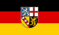
National emblem
The national emblems of the Saarland are regulated by the Saarland National Emblem Act (SHzG) of November 7, 2001 (Act No. 1483, Saarland Official Gazette , March 18, 2002, pp. 566-576). However, they have existed in this form since the laws on the coat of arms and the flag of the Saarland (laws No. 508 and 509) of July 9, 1956 (Official Journal p. 1213).
State coat of arms
The Saarland's coat of arms consists of a quartered semicircular shield, which shows the shield images of the four greatest sovereigns at the time of the Old Kingdom : in the right upper corner in a blue field sprinkled with nine silver toe crosses a gold-crowned, gold-armored and red-tongued silver double-tailed lion (the Nassau lion because of the Grafschaft Saarbrücken ), in the left upper corner in a silver field a red cut cross ( Electorate of Trier ), in the right lower corner in a golden field a red sloping bar covered with three silver mutilated eagles ( Alérion des Duchy of Lorraine ), and in the left lower corner in a black field red-crowned, red-armored and red-tongued golden lions (the Palatinate lion because of the Wittelsbach Duchy of Palatinate-Zweibrücken ). (Directional information from the point of view of the sign holder.)
The state coat of arms may only be used by state authorities and authorized persons. Private individuals can express their solidarity with the Saarland through the Saarland symbol (a stylized, modified state coat of arms embedded in the stylized Saar loop ).
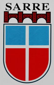
Occasionally a completely different coat of arms can be found (especially as a bumper sticker): the former state coat of arms from the period from 1948 to 1956, which was based on the Saarland flag at the time (see section "History" ). The name Sarre , which can be seen on today's stickers above the coat of arms, was never used together with the coat of arms at that time.

Coat of arms of the Saar area 1920–1935

Coat of arms of the Saar state 1947–1956

State coat of arms of the Saarland since 1957


Country flag
The state flag of the Saarland consists of the flag of Germany , on it in the middle, in the black and gold-colored stripes overlapping, the state coat of arms, the heraldic right side (from the viewer's point of view the left side) turned towards the mast (hoisting flag). It can also be designed as a banner flag, then the stripes are arranged vertically, the coat of arms is upright, the right side (from the viewer's point of view the left side) turned towards the black stripe.
After the Saarland joined the Federal Republic of Germany, this combination was chosen as the state flag to demonstrate that the Saarland belonged to Germany.
Although the flag contains the state coat of arms, the state flag can be used by any country citizen (in contrast to other state flags with coats of arms such as the flag of Berlin or Baden-Württemberg ).
Saar area
After the separation of the Saar area from the German Reich by the provisions of the Versailles Treaty in 1920, the state flag consisted of a blue-white-black tricolor . These are both the colors of the two former states of Prussia ( black and white ) and Bavaria ( white and blue ), from parts of whose areas the Saar area was formed, as well as the basic colors of the individual coat of arms fields of the coat of arms of the Saar area .
Saar state
At the time of the semi-autonomous Saarland after the Second World War, the Saarland flag consisted of a silver (white) Scandinavian cross , the background towards the mast blue, towards the other side red. The combination of colors could be interpreted as a reference to the French tricolor or the coat of arms colors of the two most important historical territories in the Saar area, namely white-red for Kurtrier and white-blue for the Wittelsbach or Bavarian Kurpfalz . The cross itself was supposed to symbolize the Christian character of all social life in Saarland after the collapse of National Socialism .

Flag of the Saar area 1920–1935
Flag of the Saar state 1947–1956
State flag of the Saarland from 1957

.svg)
anthem
The Saarlandlied is the hymn of the Saarland.
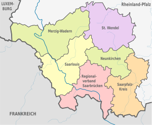
Administrative division
Counties
|
  |
Footnotes
1 Until January 1st, 2008 the association was called Stadtverband Saarbrücken .
2 Until July 9, 1989, the district was called Saar-Pfalz-Kreis .
Cities and municipalities in the districts
| Merzig-Wadern district | Saarpfalz district | Neunkirchen district | Saarlouis district | District of St. Wendel | Regional association Saarbrücken | |
|---|---|---|---|---|---|---|
 yellow = cities, pale yellow = rural communities |
The cities are in bold .
Local politics
The distribution of mayors and district administrators is as follows in the 52 cities and municipalities, as well as the six districts:
| Political party | mayor | District administrators | Total |
|---|---|---|---|
| CDU | 18th | 2 | 20th |
| SPD | 24 | 4th | 28 |
| Individual applicants | 10 | 0 | 10 |
| Total | 52 | 6th | 58 |
License Plate
The distribution of the license plates differs somewhat from the usual in Germany, because in Saarland not only is a license plate assigned to each district , but also to medium-sized towns . Therefore only the districts of Merzig-Wadern (MZG), Neunkirchen (NK), Sankt Wendel (WND) and Saarlouis (SLS) have a uniform label; In the Saarbrücken regional association, however, there is the VK for the city of Völklingen and SB for the rest of the regional association, in the Saarpfalz district there is IGB for the city of St. Ingbert and HOM (after the district town of Homburg) for the rest of the district.
There is also the SAL label for official bodies in the country.
Administrative structure before the district reform of 1974
- City of Saarbrücken (SB)
- District of Homburg (HOM)
- Merzig-Wadern District (MZG)
- District of Ottweiler (OTW) with Mittelstadt Neunkirchen (NK)
- District of Saarbrücken (SB) with Mittelstadt Völklingen (VK)
- District of Saarlouis (SLS)
- District of Sankt Ingbert (IGB)
- District of Sankt Wendel (WND)
Neunkirchen has had its own license plate (NK, previously OTW) since 1968, as does Völklingen (VK, previously SB).
Cities with more than 20,000 inhabitants
| City / municipality |
circle | Resident December 31, 2000 |
Resident December 31, 2010 |
Resident December 31, 2017 |
Development 2010-2017 in% |
|---|---|---|---|---|---|
| Saarbrücken | Regional association Saarbrücken | 183.257 | 175,741 | 180.966 | +3.0 |
| Neunkirchen | Neunkirchen | 50,882 | 47,398 | 48.173 | +1.6 |
| Homburg | Saarpfalz district | 45,769 | 43,808 | 41,934 | -4.3 |
| Völklingen | Regional association Saarbrücken | 42,990 | 39,626 | 39,376 | -0.6 |
| Saint Ingbert | Saarpfalz district | 39,971 | 37.195 | 35,951 | -3.3 |
| Saarlouis | Saarlouis | 38.182 | 37,136 | 34,532 | -7.0 |
| Merzig | Merzig-Wadern | 30,869 | 30,355 | 29,818 | -1.8 |
| Sankt Wendel | Sankt Wendel | 27.303 | 26,208 | 25,959 | -1.0 |
| Blieskastel | Saarpfalz district | 23,149 | 21,885 | 20,770 | -5.1 |
| Dillingen / Saar | Saarlouis | 21,444 | 20,808 | 20,143 | -3.2 |
Education and Research
The Saarland University , which was founded in 1948, has its offices in Saarbrücken and Homburg . Saarbrücken is the seat of the administration. Most of the courses are also located there. The Institute of Computer Science is part of the Kaiserslautern-Saarbrücken Computer Science Cluster , in which around 800 researchers work together. The Saarland cancer registry is also maintained in Saarbrücken . The campus in Homburg is the seat of the medical faculty.
The Franco-German University , founded in 1999, offers courses leading to a double or triple degree (German, French, Luxembourgish). The courses take place at universities in Germany, France and possibly a third country. The Foreign Ministers of the Federal Republic of Germany and the French Republic signed the convention on September 15, 1978, with which the Franco-German University Institute for Technology and Economics / L'Institut supérieur franco-allemand de techniques, d'économie et de sciences (DFHI / ISFATES ) with headquarters in Saarbrücken and Metz respectively. The DFHI offers a three- or five-year Franco-German study cycle with alternating study locations (Metz, Saarbrücken, Luxembourg).
The Hochschule für Musik Saar - University of Music was founded in 1947 as a state conservatory. After the establishment of an institute for Catholic church music and an institute for school music, it was converted into a State University of Music in 1957 and transferred to the Saarland in 1971.
The Saar College of Fine Arts was founded in its current form in 1989 as an art college with university status and emerges from the State School for Arts and Crafts, which was founded in 1924, and the School for Arts and Crafts that existed from 1946 .
There are the following universities of applied sciences in Saarland
- The Saarland University of Technology and Economics (HTW), founded in 1971 through the merger of the Higher Business School, the State Engineering School and the State Craft School, was given its current name in 1991. Furthermore, from 2005 the HTW took over the social science faculty of the Catholic University for Social Work, which was completely closed three years later. Here, too, there is Franco-German cooperation (especially with the Grenoble École de Management ).
- The University of Applied Sciences for Administration of the Saarland in Göttelborn trains the candidates for the civil service career of the higher service .
The following private research institutes are located on the campus of Saarland University:
- the Max Planck Institute for Computer Science (founded in 1988);
- the Max Planck Institute for Software Systems (founded in 2004);
the Max Planck Society ;
- the Helmholtz Center for Information Security (CISPA) (founded in 2017)
the Helmholtz Association of German Research Centers ;
- the Fraunhofer Institute for Non-Destructive Testing (IZFP) (in Saarbrücken) and
- the Fraunhofer Institute for Biomedical Technology (IBMT) (in St. Ingbert )
the Fraunhofer Society ;
- the Leibniz Institute for New Materials (INM);
- the German Research Center for Artificial Intelligence (DFKI);
- the Korean Institute of Science and Technology (KIST) Europe, the European branch of one of the largest Korean research institutes founded in 1996;
- the Intel Visual Computing Institute ;
- the Cluster of Excellence Multimodal Computing & Interaction (MMCI);
- the Saarbrücken Graduate School of Computer Science ;
- the Center for Bioinformatics (CBI);
- the IT competence center at Saarland University;
- International conference and meeting center for IT at Schloss Dagstuhl ;
- the Helmholtz Institute for Pharmaceutical Research Saarland (HIPS);
- the Office for Austrian Literature and Culture ( AfÖLK ) / Robert Musil Research within German Studies ;
- the SaarLernNetz as the central point of contact for everything to do with education.
Historical colleges
- The Catholic University for Social Work existed from 1971 to 2008. It was sponsored by the Diocese of Trier .
Apprenticeships
In the annual dynamic ranking of the federal states of the New Social Market Economy Initiative, Saarland takes first place in the field of training place placement. The number of apprenticeships on offer increased at an above-average rate from 2004 to 2006. With a plus of 4.0 percentage points, Saarland is clearly ahead of all other federal states.
religion
While Germany is currently characterized by around 1/3 Protestants and Catholics and non-denominational or members of other religions, Saarland is the only country with a Catholic majority in 2018 with 56.8%.
The members of the two Protestant regional churches represented in Saarland ( Evangelical Church in the Rhineland and Evangelical Church in the Palatinate ) achieve a share of 17.5%.
The others, consisting of other religions and non-denominational groups, come together to 25.7%.
Economy and Infrastructure
power supply
In June 2012, the Saar mine, the last coal mining operation, was shut down. In the (now former) coal mining region there are or were 4 larger coal power plants : the Bexbach power plant , the Ensdorf power plant , the Fenne power plant and the Weiher power plant . The development of renewable energies began in 1995 with the Freisener Höhe wind farm. Up to 2013, wind turbines with a total output of 138 MW were connected.
In 2014, the electricity mix in Saarland was made up as follows: 60.2% hard coal, 19.5% natural gas, 10% renewable energies, 10.3% other.
economy
The economic development of the Saarland is closely related to the regional structural change that went hand in hand with the cessation of hard coal mining. Until the middle of the 20th century, mining and the associated steel industry were the main employers in the region and shaped the country's economic infrastructure. From the 1960s onwards, with a gradual decline in mining, a comprehensive change began, which was intensified in the 1980s by a drastic reduction in production volumes. However, the settlement of the automotive industry has also created new jobs.
In 2005 the Saarland had the highest economic growth rates in terms of gross domestic product . In the first half of 2005 it was 2.8 percent higher in real terms than in the same period of the previous year, while the national average was only 0.6 percent growth.
Furthermore, Saarland has won the dynamic ranking of the New Social Market Economy initiative several times , which evaluates the changes in the federal states. Prime Minister Peter Müller assessed this as a success of his reform policy, which led to the establishment of new branches of industry and services.
In comparison with the gross domestic product of the European Union , expressed in purchasing power standards, the Saarland achieved an index of 119 (EU-28: 100, Germany: 126) (2014).
In 2019, the economic output in the federal state of Saarland measured in terms of GDP was around 36.25 billion euros. While the country's debt level was around 9.1 billion euros in December 2007, it had increased to 13.9 billion euros by March 2020.
The country has been presenting itself with a new image campaign since 2014. The motto "Big things always come from small things" and the measures linked to it promote the country as a place to live and do business.
Companies

- The most important economic area on the Saar today is the automotive industry with Ford in Saarlouis, together with the associated supplier industry with Bosch , INA and Michelin in Homburg, ZF Friedrichshafen in Saarbrücken and Eberspächer in Neunkirchen. With almost 9,000 employees, ZF is the largest industrial employer in Saarland.
- With the Saarstahl AG and the AG der Dillinger Hüttenwerke two large steel companies in the Saarland are located.
- Larger employers from the electrical engineering industry are the Hager Group in Blieskastel and Festo in Rohrbach .
- The ceramics industry ( Villeroy & Boch ) also plays an important role in the Saarland's economy.
- The areas of computer science and the information industry, Scheer in Saarbrücken and SAP in St. Ingbert, are strongly promoted and growing .
- Coal mining was an important industry. This was also of great importance for the population development.
labour market
Only the city states of Bremen, Hamburg and Berlin have a higher rate of commuters than the Saarland. 52,000 people commute to work in Saarland, and vice versa, almost 28,000 people from Saarland commute, mainly to Rhineland-Palatinate and North Rhine-Westphalia.
The ten most important locations of employment subject to social insurance are ( place of work ):
| city | social insurance Employees June 30, 2012 |
Change since June 30, 2007 |
Commuter balance June 30, 2012 |
Job density 1 |
|---|---|---|---|---|
| Saarbrücken | 107,799 | + 6.34% | +52,255 | 943 |
| Homburg | 31,638 | +5.93% | +16,984 | 1,214 |
| Saarlouis | 26,701 | + 6.83% | +14,547 | 1,237 |
| Neunkirchen | 20,376 | −0.75% | +4,887 | 701 |
| St. Ingbert | 16.306 | + 4.64% | +3,476 | 726 |
| Völklingen | 14,274 | + 10.49% | +1,934 | 600 |
| Dillingen | 13,911 | + 8.03% | +6,822 | 1,087 |
| St. Wendel | 12,991 | + 9.35% | +3,777 | 784 |
| Merzig | 10,188 | +0.66% | +892 | 542 |
| Sulzbach | 7,611 | + 16.63% | +1,897 | 733 |
traffic
Due to its early and intensive industrialization , the Saarland has a very good transport infrastructure . Nowhere in Germany was there such a dense rail network for passenger traffic as in Saarland, until the German Federal Railroad began to no longer serve many routes in the 1960s. The small-scale structure in large parts of the state has meant that today, with an average of 704 motor vehicles per 1000 inhabitants, most of the cars are registered in Saarland in relation to the population in a large German state.
The most important rail connection is the Mannheim - Paris route . For this purpose, from 2006 to December 2007 the Saarbrücken main train station was converted into the "Europabahnhof". From June to December 2007, initially only one ICE pair from Paris to Frankfurt (Main) drove via Saarbrücken, which was using a new high-speed route in France; two more ICE pairs ended in Saarbrücken for the time being. Since December 2007, five ICE pairs have been running between Germany and France that only stop in Saarbrücken in Saarland. Saarbrücken is connected to the French high-speed network LGV Est européenne (travel time Saarbrücken – Paris: one hour, 50 minutes). Further long-distance traffic on the Saarbrücken-Kaiserslautern-Mannheim-Frankfurt (Main) line is served daily by several IC and ICE trains, including one pair of trains to Dresden , once a day to Stuttgart and back, and a pair of trains to / from Graz via Munich. On all other routes in Saarland, only regional trains are now running, after the InterRegio trains that ran on the Saar route in the direction of Koblenz-Cologne-Northern Germany were deleted from the timetables in December 2002 . On the Nahe Valley Railway and the Landau-Rohrbach railway since 1991 no run express trains more.
In 1997, the Saarbahn, the tram that was abolished in 1965, returned to Saarbrücken .
On August 1, 2005, a network tariff was introduced with the Saarland Transport Association (SaarVV). Before that, there was only the Saar Transport Association, which provided a number of tariff cooperations and ensured free travel for the severely disabled.
The Saarbrücken Airport -Ensheim is an international airport with about 12,000 takeoffs and landings annually. Other international airports are located in the immediate vicinity of the Saarland: Zweibrücken and Hahn .
The lower reaches of the Saar are developed for large shipping from Konz to above Saarbrücken . From Saarbrücken to Saargemünd , the river is navigable for smaller ships ( Penischen ). From Sarreguemines the Saar over the Saar channel (formerly Sarre channel called) to the Marne-Rhine canal.
Operated railway lines
| Course book no. | Route name | Important stations |
|---|---|---|
| 682 | Forbacher Bahn | Saarbrücken Hbf - Forbach (France) - Metz (France) - Paris, Gare de l'Est (France) |
| 670 | Mannheim – Saarbrücken railway line | Saarbrücken Hbf - St. Ingbert - Homburg (Saar) Hbf - Kaiserslautern - Mannheim |
| 674 | Landau – Rohrbach railway line | Saarbrücken Hbf - St. Ingbert - Zweibrücken - Pirmasens (- Landau (Pfalz)) |
| 680 | Nahe Valley Railway | (Frankfurt am Main -) Mainz - Türkismühle - St. Wendel - Neunkirchen (Saar) Hbf - Saarbrücken Hbf |
| 681 | Primstalbahn / Fischbachtalbahn | Saarbrücken - Illingen - Lebach-Jabach |
| 683 | Palatine Ludwigsbahn / Primstalbahn | Homburg / Saar Hbf - Bexbach - Neunkirchen (Saar) Hbf - Illingen |
| 684 | Upper Saartalbahn / Europabahn | Saarbrücken Hbf - Sarreguemines (France) - Strasbourg (France) - Offenburg |
| 687 | Niedtalbahn | Dillingen - Niedaltdorf (- Bouzonville (France) ) |
| 690 | Moselle route / Saar route | Saarbrücken Hbf - Völklingen - Saarlouis Hbf - Dillingen - Trier - Cologne |
| 692 | Upper Moselle route | Metz - Thionville - Apach (France) - Perl - Trier |
| without / partially 684 (Brebach - Sarreguemines) | Saarbahn | Lebach - Heusweiler - Walpershofen - Riegelsberg - Saarbrücken - Brebach - Sarreguemines (France) |
| 12683 | Ostertalbahn | Ottweiler - black earth |
This mode of transport formed its own state railway, the Saarland Railways (EdS) , until 1956 .
Streets
The Saarland is crossed by the following motorways :
| BAB | Route in Saarland | Further course |
|---|---|---|
| A 1 | Saarbrücken - Riegelsberg - Nonnweiler - | AD Moseltal (near Trier ) - Eifel - Cologne - Münster - Bremen - Hamburg - Heiligenhafen approx. 730 km |
| A 6 | Saarbrücken Goldene Bremm ( French border ) - St. Ingbert - Homburg - | Kaiserslautern - Mannheim - Heilbronn - Nuremberg - Waidhaus ( Czech border ) approx. 477 km |
| A 8 | Perl ( Luxembourg border ) - Saarlouis - Neunkirchen - | Zweibrücken - Pirmasens - Landau - Karlsruhe - Stuttgart - Ulm - Munich - Bad Reichenhall - Austrian border approx. 500 km |
| A 62 | northern edge areas south of the high forest | Kusel - Landstuhl - Pirmasens approx. 80 km |
| A 620 | Saarlouis - Völklingen - Saarbrücken approx. 30 km | |
| A 623 | Saarbrücken - AD Friedrichsthal approx. 10 km |
There are also a number of important federal highways :
Since the Saarland has no district roads , the network of state roads is particularly dense. The district roads are the state roads of the second order in Saarland , as they are responsible for the district, while the state roads of the first order are responsible for the state .
Attractions
In the Saarland, there is a wealth of sights from the fields of nature and technology and lots of monuments and works of art to discover, sometimes in a very small space.
media
Along with the Free Hanseatic City of Bremen, Saarland is the smallest federal state with its own public broadcaster , Saarland Broadcasting . The SR is a member of the ARD and has its seat in Saarbrücken. Among other things, he operates SR television and five radio programs.
The Landesmedienanstalt Saarland (LMS) is an institution under public law and has its seat in Saarbrücken. It is a state control authority and is responsible for the licensing and control of private radio and television stations as well as their coordination with the public broadcasters. On behalf of the state, LMS continues to promote film and provide media skills . Radio Salü is a private radio station based in Saarbrücken, whose range covers the entire Saarland. Since June 5, 2008, the state capital Saarbrücken has its own local radio station with Radio Saarbrücken 99.6.
The only daily newspaper in Saarland is the Saarbrücker Zeitung , which on the one hand covers the entire Saarland as a regional newspaper, but also provides local reporting with eleven local editorial offices as a local newspaper . As a weekly advertising paper, the Wochenspiegel supplements the Saarland media landscape with extensive editorial content. The Wochenspiegel also has nine local editorial offices. The Rhineland-Palatinate regional daily newspapers Die Rheinpfalz and Pfälzischer Merkur cover the Saar-Palatinate district and the state of Saarland in their reporting . For several years now, two online magazines have been operated in Saarland : Saar Report and Saar-Zeitung (distribution area: Saarlouis district , Saarbrücken regional association ).
Some lifestyle magazines with regional references are published in Saarland ( TOP-Magazin , L! VE , Eurosaar , Background , Saar-Revue ). Since March 31, 2005 the newspaper Bild has been published as Bild Saarland with a regional section.
.saarland domains
| Top-level domain .saarland | |
|---|---|
| introduction | October 30, 2014 |
| category | nTLD |
| Registry | dotSaarland GmbH |
| Award | unrestricted |
Since October 30, 2014, domains with the ending .saarland can be registered. The administration of the domains is taken over by dotSaarland GmbH.
The sunrise phase began on July 18, 2014 and ended on September 15, 2014. The first domain (apart from the registry) has been available since September 23, 2014.
Arts and Culture
A list of artists (literature, visual arts, music, performing arts) who were born in Saarland or worked there can be found here .
Architectural monuments
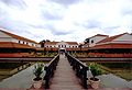
The Saarland is home to some land and architectural monuments of European standing, such as the Celtic and Roman excavations on the Upper Moselle (municipality of Perl with the districts of Nennig and Borg ) and in Bliesgau ( Bliesbrück-Reinheim and Schwarzenacker ), as well as the so-called Hunnenring in Otzenhausen . The baroque Ludwigsplatz with the Ludwigskirche in Saarbrücken date from modern times . In the World Heritage list of UNESCO , the historical is Völklingen to find.

Roman mosaic floor in pearl
Reconstructed Roman villa in Borg
Reconstructed Gallo-Roman temple in the Roman Museum in Schwarzenacker
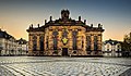
The Ludwig Church in Saarbrücken
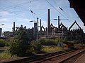
The Völklingen Ironworks World Heritage Site
.jpg)


Jewish cemeteries
There are 16 Jewish cemeteries in Saarland : in Blieskastel , Dillingen , Homburg , Illingen , Merzig , Neunkirchen , Nohfelden-Gonnesweiler , Nohfelden-Sötern , Ottweiler , Saarbrücken (old) , Saarbrücken (new) , Saarlouis , Saarwellingen , St. Ingbert , St Wendel and Tholey .
Art collections
The most important art collection of the Saarland is home to the Modern Gallery of the Saarland Museum in Saarbrücken with paintings of German Expressionism , especially the famous Little Blue Horse by Franz Marc . A special focus of the museum's collection is on Alexander Archipenko ; the collection has 107 plaster models and numerous bronze casts by the artist.
The St. Ingbert Museum was opened in 1987 by the Albert Weisgerber Foundation . It was closed in July 2007 on the proposal of the St. Ingbert city administration and a resolution of the St. Ingbert city council.
Museums
The Historical Museum Saar on Schlossplatz in Saarbrücken shows the country's history and points out cultural, social, economic, industrial and technical-historical aspects of the Saarland. The permanent exhibition presents the eventful history of the Saar region and today's Saarland from 1870 to the second half of the 20th century on 1700 m² using art and design objects, but also many everyday objects.
Visitors to the Saarland Mining Museum in Bexbach can experience the special importance of mining for the region . It deals exclusively with hard coal mining from its early beginnings in the 15th century to the mid-1980s.
music
With the Deutsche Radio Philharmonie Saarbrücken Kaiserslautern, the Saarland has an ensemble of European standing. The orchestra was created in 2007 through the merger of the Saarbrücken Radio Symphony Orchestra and the Kaiserslautern Radio Orchestra . Well-known conductors were Hans Zender and Christoph Poppen .
In popular music, Sandra , Ingrid Peters , the producer Frank Farian and the first German ESC winner Nicole are important. Well-known bands are Powerwolf and Blackeyed Blonde . Genetikk and DCVDNS are known in rap music .
The jazz musicians include Oliver Strauch (drums), Christof Thewes (trombone), Georg Ruby (piano) and Nicole Johänntgen (saxophone).
The most important festivals are the Rocco del Schlacko (rock / pop), the SR Ferien Open Air St. Wendel (pop), the electro magnetic (techno / electro), the jazz festival St. Ingbert and the Saar music festival (classical).
Saarland literature
Two writers from Saarland in particular have become known from the recent past: the novelist Ludwig Harig and the poet Johannes Kühn . Other well-known writers related to Saarland are u. a. Gustav Regulator , Kerstin Rech , Alfred Gulden , Arnfrid Astel , Johannes Kirschweng and Florian Russi (Rudolf Dadder).
Descriptions of the Saar region worth mentioning can be found in Poetry and Truth (2nd part, 10th book) by Johann Wolfgang von Goethe and in Soldiers' Life by Johann Michael Moscherosch . In contemporary literature, Die Saarländische Freude and Das Saarland by Ludwig Harig and Travels with Pippo by Holger Willi Montag should be highlighted.
Theater and film
The most important international festival of young German film takes place annually in January in Saarbrücken, the after-born Saarbrücken director Max Ophuls named Max Ophüls Prize .
In Saarbrücken there is also a large, three-part theater with the Saarland State Theater. In recent years, Marguerite Donlon's ballet company and the musical productions carried out in collaboration with Frank Nimsgern have gained international attention.
After all, the Franco-German festival Perspectives has been enriching the German cultural scene as the only theater festival of its kind since 1977.
On the Gräfinthal natural stage and the Hülzweiler open-air stage , you can experience outdoor theater in summer. The open-air stage in Gräfinthal plays two pieces every year, and one piece is performed in Hülzweiler. Both theaters look back on a long tradition.
Saarland specialties
Traditional Saarland cuisine consists of simple regional products: potatoes, vegetables, sauerkraut, corn flour, sausage and meat. Typical Saarland food and drinks are:
- Dibbelabbes and Schaales (similar dough to potato pancakes )
- Lyoner ( meat sausage ) in the ring
- Hoorische (potato dumplings made from raw potatoes)
- Gefillde (filled potato dumplings)
- Geheirade ("married", combination of dumplings and potatoes with light bacon sauce)
- Double purpose (bread roll)
- Snowballs (very fluffy, fluffy potato dumplings)
- Swivel (typical swivel steak )
- Bettsichersalat ( dandelion salad ; seichen = urinate, because of the diuretic effect; in French the dandelion is officially called pissenlit = pee into bed)
- Well-known Saarland beers come and came from the breweries Becker (St. Ingbert), Bruch (Saarbrücken), Donner (Saarlouis), Großwald (Heusweiler-Eiweiler), Gross (Riegelsberg), Karlsberg (Homburg), Neufang (Saarbrücken), Ottweiler Brewery, Paqué (St. Wendel), Saarfürst (Merzig), Schäfer (Dirmingen), Castle (Neunkirchen) and Walsheim (Walsheim). Karlsberg dominates the beverage market in Saarland today (2012), most of the former Saarland beer brands belong to the Karlsberg Group today, but not the two breweries Bruch and Grosswald, which, in contrast to Karlsberg, are still 100 percent privately owned.
- The Saar wines (growing area Mosel-Saar-Ruwer ) do not come from the Saarland, but from the lower reaches of the Saar in Rhineland-Palatinate . Saarland wines are grown on the short section of the Moselle called the Upper Moselle (for wine marketing also: "Southern Wine Moselle "), the border between Saarland and Luxembourg .
- Viez ( apple wine ) is mainly produced in the Merziger area and on the Saargau .
- Fruit schnapps are produced in almost all parts of the country, but especially in Bliesgau and Saargau . Is fired across the orchard: cherry , apple , wild pear , pinching ( plum ), mirabelle , pomace , sloe or the rare specialty Hundsärsch , a loquat -Brand.
Others
- At the 1952 Summer Olympics in Helsinki, Saarland provided an independent, at the time the second, German Olympic team through the Saarland NOK (SAA) . Until 1956 the Saarland ( SFB ) took part in international competitions as an independent FIFA member with the Saarland soccer team. a. in qualifying for the 1954 World Cup .
- Since 2004, the individual euro countries have been allowed to issue a 2 euro commemorative coin each year . In order to provide information about federalism in Germany in the other countries of the European Union , the Federal Republic presents itself every year on the back of the coins with the state that holds the Federal Council presidency. In 2009 the Saarbrücker Ludwigskirche was imprinted for the Saarland .
- In the German media, the Saarland is used disproportionately as a unit of measurement to clarify the size of countries or the extent of natural disasters (for example: “ Switzerland is almost 16 times as large as Saarland” or “[...] more than 1000 square kilometers below Water - an area almost half the size of Saarland ”). The reason for this is not known. According to ZEIT, the Saarland was used most as a unit of measurement by the German federal states between 2001 and 2011 (in 209 press articles), followed by Bavaria (in 178 press articles). This phenomenon also exists in the United States , where Rhode Island (the smallest US state) is mentioned disproportionately as a size comparison in the US media.
See also
- Saarland Art Prize
- Saarland circular hiking trail
- Saarland sagas and legends
- (6099) Saarland (asteroid)
literature
- Hektor Ammann, Heinz Quasten: Historical atlas for the country on the Saar . Inst. Für Landeskunde im Saarland, Saarbrücken 1991, ISBN 3-923877-80-3 (4 deliveries, 45 cards, 12 explanatory booklets).
- Wolfgang Behringer, Gabriele Clemens: History of the Saarland, Munich 2009.
- Paul Burgard, Ludwig Linsmayer: The Saar state - images of a past world. [L'Etat Sarrois - Images d'un monde passé]. Texts in German and French (= echo sounder. Historical contributions from the Saarbrücken State Archives. Volume 2). Self-published by the Landesarchiv, Saarbrücken 2005, ISBN 3-9808556-2-7 .
- Gabriele B. Clemens and Eva Kell (eds.): Prussia on the Saar. A conflicted relationship (1815–1914) . Commission for Saarland State History and Folk Research eV, Saarbrücken 2018, ISBN 978-3-939150-11-4 .
- Joachim Conrad, Stefan Flesch (ed.): Castles and palaces on the Saar. 3. Edition. Minerva, Saarbrücken 1995.
- HP Dörrenbächer, O. Kühne, JM Wagner (eds.): 50 Years of Saarland in Transition (= publications by the Institute for Regional Studies in Saarland. Volume 44). Saarbrücken 2007, ISBN 978-3-923877-44-7 .
- Thomas Fläschner, Frank Hunsicker: Traffic and Mobility in Saarland - Past and Present (= publications of the Institute for Regional Studies in Saarland . Volume 47 ). Institute for Regional Studies in Saarland, Saarbrücken 2009, ISBN 978-3-923877-47-8 , p. 126 .
- Nikolaus Fox: Saarland Folklore, Saarbrücken 1927.
- Jürgen Hartmann (Ed.): Handbook of the German federal states. Federal Agency for Political Education, Bonn 1997, ISBN 3-89331-083-5
- Hans-Walter Herrmann (Ed.): Historical regional studies of the Saarland, 3 volumes, 1960–1994.
- Hans-Walter Herrmann u. Georg Wilhelm Sante: History of the Saarland, Würzburg 1972.
- Martin Klewitz : Saarland ( German Land, German Art ). 3rd, modified and expanded edition, Munich / Berlin 1982
- Bernd Kissel: SaarlandAlbum (comic) Geistkirch-Verlag, Saarbrücken 2011, ISBN 978-3-938889-33-6 .
- Ludwig Linsmayer (Ed.): January 13th. The Saar at the focus of history (= echo sounder. Historical contributions from the Saarbrücken State Archives, Volume 1). Self-published by the Landesarchiv, Saarbrücken 2005, ISBN 3-938415-00-2 .
- Ludwig Linsmayer (Hrsg.): The birth of the Saarland. On the dramaturgy of a special path (= echo sounder. Historical contributions from the Saarbrücken state archive. Volume 3). Self-published by the Landesarchiv, Saarbrücken 2007, ISBN 3-9808556-3-5 .
- Peter Neumann (Ed.): Saarländische Lebensbilder. 4 volumes. Saarbrücken printing and publishing house, Saarbrücken 1982–1989.
- Hermann Overbeck u. Georg Wilhelm Sante (Ed.): Saar Atlas, Gotha 1934.
- Heinz tassels u. Hans Walter Herrmann (Ed.): Historical Atlas for the Land on the Saar, Saarbrücken 1971.
- Kerstin Rech : The Schlager, the Saarland and the Seventies Geistkirch Verlag, Saarbrücken 2017, ISBN 978-3-946036-68-5 .
- Dietrich Soyez (ed.): Persistence and change in a peripheral border area. Geographisches Institut, Saarbrücken 1989, ISBN 3-924525-36-6 ( Das Saarland. Volume 1).
- Dietrich Soyez (Ed.): The Saar - a river landscape changes its face. Geographisches Institut, Saarbrücken 1989, ISBN 3-924525-37-4 ( Das Saarland. Volume 2).
- Dieter Staerk (Ed.): The Saarland Book. Minerva, Saarbrücken 1981, ISBN 3-477-00066-8 .
- Andreas Stinsky: Saarland - journey of discovery to 60 exciting places of history, Mainz 2019, ISBN 978-3-96176-016-9 .
Web links
- Official website of the Saarland
- Saarland biographies
- Saarland bibliography
- State Parliament of the Saarland
- Saarland Tourist Office
- Maps and pictures of the Saarland
- saar-nostalgie.de - Memories of the semi-autonomous Saarland from 1945 to 1959 with numerous photos, documents, etc.
- Literature from and about Saarland in the catalog of the German National Library
Individual evidence
- ↑ Saarland.de - Official population figures as of December 31, 2019 (PDF; 20 kB) ( help ).
- ↑ Unemployment rates in July 2020 - countries and districts. In: statistik.arbeitsagentur.de. Statistics from the Federal Employment Agency, accessed on August 11, 2020 .
- ↑ Gross domestic product of Saarland since 1970 on statista.com, accessed on January 9, 2018
- ↑ Source: destatis, public debt as of December 31, 2016
- ↑ Current seating arrangements in the Landtag ( memento of the original from March 27, 2017 in the Internet Archive ) Info: The archive link was inserted automatically and has not yet been checked. Please check the original and archive link according to the instructions and then remove this notice. State Parliament of the Saarland
- ↑ Day X for the Saar is approaching , Die Zeit , April 1959.
- ^ Horst Schneider: Saarland, Geological Guide Collection , Vol. 84, Berlin, Stuttgart 1991.
- ↑ Herbert Liedtke, Michel Deshaies, Patrice Gamez, Dominique Harmand, Hubertus Preusser: The surface forms in the border region Saarland - Lorraine - Luxembourg / Les formes de relief dans la région frontalière Sarre - Lorraine - Luxembourg , publications of the Institut für Landeskunde im Saarland, volume 48, Saarbrücken 2010.
- ↑ Indicators and maps for spatial and urban development [electronic resource]. INKAR. Edition 2013. Ed .: Federal Institute for Building, Urban and Spatial Research (BBSR) in the Federal Office, Wiesbaden, for Building and Spatial Planning (BBR), Bonn 2013 - DVD-ROM.
- ↑ Andreas Bettinger, Olaf Kühne: Diversity between borders, a geographical regional study of the Saarland. Volume 1: Nature - Landscape - Environmental Protection (publications by the Institute for Regional Studies in Saarland, Volume 51), Saarbrücken 2016, p. 52.
- ↑ Official Gazette of the Saar Regional Council 1946, No. 32, page 131 f.
- ↑ Ordinance No. 93 on the reorganization of the administration of the Rhine Palatinate and the Saar area with effect from June 8, 1947, Journal Officiel du Commandement en Chef Français en Allemagne, Année 3 (1947), no. 77, page 765 f.
- ↑ Saarland Official Gazette No. 26 (S) - 1949 of April 23, p. 377.
- ^ Statistical Office of the Saarland: Territorial status of the Saarland from April 23, 1949.
- ↑ France Strategy | Saarland.de. Retrieved August 2, 2019 .
- ↑ France Strategy | Saarland.de. Retrieved August 2, 2019 .
- ^ France strategy: The Saarland is to become bilingual . In: Frankfurter Allgemeine Zeitung , January 21, 2014.
- ↑ When evaluating the figures in this table, it must be noted that Saarbrücken was enlarged several times after 1896 through incorporations.
- ↑ a b Saarland Statistical Office ( Memento of the original from January 19, 2012 in the Internet Archive ) Info: The archive link was inserted automatically and has not yet been checked. Please check the original and archive link according to the instructions and then remove this notice. (PDF; 17 kB)
- ↑ Norbert Freund: Saarlanders are getting fewer and fewer. ( Memento of the original from July 19, 2011 in the Internet Archive ) Info: The archive link was inserted automatically and has not yet been checked. Please check the original and archive link according to the instructions and then remove this notice. Saarbrücker Zeitung , June 23, 2010.
- ↑ Birth rate - children per woman in Germany by federal state in 2017. Accessed on October 28, 2019 .
- ↑ Life expectancy in Germany by federal state and gender in 2015/2017. Retrieved October 22, 2019 .
- ↑ BBSR Homepage - Federal Institute for Building, Urban and Spatial Research (BBSR) - Research and policy advice - Where life expectancy is highest in Germany. Retrieved October 22, 2019 .
- ↑ Announcement of January 21, 1998, Official Journal p. 290.
- ↑ Illustration at www.saar-nostalgie.de
- ^ Kurt Hoppstädter : The coat of arms of the Saarland, Part I. Ed .: Historical Association for Saarland e. V. in cooperation with the regional archive of the Saarland government (journal for Saarland local history, 3rd year, issue 1–4), Saarbrücken 1953, pp. 13–14.
- ^ Rolf Wittenbrock : … You holy land on the Saares beach, denominational school and search for identity. In: From 'Hour 0' to 'Day X', Das Saarland 1945–1959. Catalog for the exhibition of the Regional History Museum in the Saarbrücker Schloß , Saarbrücken 1990, pp. 257–272, here: p. 267.
- ^ Saarland song (PDF; 4 kB), Saarland website, 2003.
- ^ Saarland University: History , accessed on May 17, 2018.
- ↑ Universities in Saarland at www.saarland.de , accessed on May 17, 2018.
- ↑ Evangelical Church in Germany - Church membership numbers as of December 31, 2018 EKD, January 2020
- ^ Saarland says goodbye to the mining era , Focus , July 1, 2012.
- ↑ www.thewindpower.net ( Memento of the original from November 3, 2013 in the Internet Archive ) Info: The archive link was inserted automatically and has not yet been checked. Please check the original and archive link according to the instructions and then remove this notice. (engl.)
- ↑ Share of energy sources in net electricity generation in Saarland in 2014 , Statista , accessed on March 29, 2017.
- ^ Structural change: Saarland with a broad chest in difficult times. Handelsblatt, April 20, 2009.
- ^ Structural change: Spark of hope over the Saar. Frankfurter Allgemeine Zeitung , January 21, 2012.
- ↑ Gross domestic product (GDP) at current market prices by NUTS 3 regions. Eurostat , February 26, 2016, accessed on December 3, 2016 .
- ↑ Gross domestic product of Saarland until 2019. Accessed on July 14, 2020 .
- ↑ Debt of the federal states in Germany 2020. Accessed on July 14, 2020 .
- ↑ Saarland: Welcome to Saarland.de. Retrieved October 27, 2018 .
- ↑ The 50 largest Saarland industrial companies , accessed on June 16, 2020.
- ↑ Many people commute to Saarland to work. ( Memento of the original from July 19, 2011 in the Internet Archive ) Info: The archive link was inserted automatically and has not yet been checked. Please check the original and archive link according to the instructions and then remove this notice. Saarbrücker Zeitung , May 8, 2010.
- ^ Statistics from the Federal Employment Agency
- ↑ census database
- ↑ The Saarland goes online - .SAARLAND. (PDF) (No longer available online.) Archived from the original on September 24, 2015 ; accessed on March 19, 2015 . Info: The archive link was inserted automatically and has not yet been checked. Please check the original and archive link according to the instructions and then remove this notice.
- ↑ .saarland is officially launched. (No longer available online.) September 23, 2014, archived from the original on April 2, 2015 ; accessed on March 19, 2015 . Info: The archive link was inserted automatically and has not yet been checked. Please check the original and archive link according to the instructions and then remove this notice.
- ↑ Felicitas Grützmann (editor): Overview of all projects for the documentation of Jewish grave inscriptions in the area of the Federal Republic of Germany ; here: Saarland
- ↑ Although Saarland was still nominally independent in 1956, the Saarland athletes took part in the 1956 Olympic Games as part of the all-German Olympic selection .
- ↑ The flood is here - and will stay for the time being. Lübecker Nachrichten , June 11, 2013, accessed on July 13, 2013 .
- ↑ Marco Krefting: The Saarland - the comparative measure of many things. Die Welt , February 18, 2010, accessed July 12, 2013 .
- ^ Matthias Stolz: Map of Germany: size comparisons. Die Zeit, November 16, 2011, accessed on July 13, 2013 .
- ^ Nicole Frank: Saarland unit of measurement. (No longer available online.) Society for German Language , archived from the original on April 23, 2014 ; Retrieved July 13, 2013 . Info: The archive link was inserted automatically and has not yet been checked. Please check the original and archive link according to the instructions and then remove this notice.
Current countries:
|
|
|
|
|
|
|
|
|
|
|
|
|
|
|
|
|
|
|
|
Former countries:
|
|
|
|
Coordinates: 49 ° 23 ' N , 6 ° 50' E