
Neunkirchen district
| coat of arms | Germany map |
|---|---|

|

Coordinates: 49 ° 23 ' N , 7 ° 7' E |
| Basic data | |
| State : | Saarland |
| Administrative headquarters : | Ottweiler |
| Area : | 249.24 km 2 |
| Residents: | 131,408 (Dec. 31, 2019) |
| Population density : | 527 inhabitants per km 2 |
| License plate : | NK |
| Circle key : | 10 0 43 |
| NUTS : | DEC03 |
| Circle structure: | 7 municipalities |
| Address of the district administration: |
Wilhelm-Heinrich-Strasse 36 66564 Ottweiler |
| Website : | |
| District Administrator : | Sören Meng ( SPD ) |
| Location of the Neunkirchen district in Saarland | |
  |
|
The district of Neunkirchen is a district in Saarland . He was called by the end of 1973 County Ottweiler and since 1985, Germany's first and only Rose district with over 20,000 rose bushes in nine rose gardens.
geography
After the Hessian Main-Taunus-Kreis , the district of Neunkirchen is the second smallest district in Germany in terms of area, but the former has around 100,000 more inhabitants.
location
The landscape of the Neunkirchen district mainly belongs to the Saar-Nahe-Bergland. The largest lake in the district is located in the Itzenplitz Heiligenwald recreation area .
Neighboring areas
The district borders in a clockwise direction in the northeast on the districts of Kusel (in Rhineland-Palatinate ), Saarpfalz-Kreis , Saarbrücken Regional Association , Saarlouis and St. Wendel (all in Saarland).
history
The foundation stone for today's Neunkirchen district was laid when the county of Saarbrücken was divided up among the sons of Count Johann Ludwig in 1545. The territorial unit existed until 1814 under changing names such as Herrschaft Ottweiler (1544 to 1611), Amt Ottweiler and Oberamt Ottweiler (1611 to 1798) and, under Napoleonic rule, Canton Ottweiler (1798 to 1800).
On June 30, 1814, the first district of Ottweiler was created as part of a reorganization under now Prussian rule . It was directed by a district director and extended over an area of 1186 km² with 63,517 inhabitants. Two years later, on May 1, 1816, the Trier administrative district was formed. When it was redistributed into districts, a new, much smaller district of Ottweiler was formed, headed by a district administrator in accordance with Prussian administrative regulations. The seat of the district administration was Ottweiler, which was also the residence of the district administrator.
After the First World War , the Saar area, and with it the district of Ottweiler, was separated from the German Empire by the Treaty of Versailles and placed under a League of Nations mandate in 1920 .
By order of the French occupying power of the county was on 1 October 1946, the municipalities Weiler , hasborn-dautweiler , Lindscheid , Neipel , chafing , Sotzweiler , Theley , Tholey and About Roth-Niederhofen from the district Sankt Wendel. In return, the communities of Steinbach and Wetschhausen moved from the Sankt Wendel district to the Ottweiler district.
As part of the Saarland regional reform , the Ottweiler district gave the four communities of Aschbach , Dörsdorf , Steinbach and Thalexweiler to the Saarlouis district on January 1, 1974 , and they became part of the city of Lebach there. The municipality of Berschweiler also left the district and became part of the municipality of Marpingen in the St. Wendel district. The municipality of Mainzweiler from the St. Wendel district was incorporated into the city of Ottweiler. The number of parishes in the district was reduced from 35 to seven through various amalgamations. At the same time, the district of Ottweiler was renamed the district of Neunkirchen . The district administration remained in Ottweiler. The largest city in the district is the district town of Neunkirchen , which is also the second largest city in Saarland, and the smallest municipality is Merchweiler .
Population development
| year | Residents | source |
|---|---|---|
| 1816 | 17,972 | |
| 1847 | 29,412 | |
| 1871 | 51,974 | |
| 1885 | 70,593 | |
| 1900 | 102,729 | |
| 1910 | 126,946 | |
| 1939 | 142,532 | |
| 1960 | 162,600 | |
| 1970 | 167,300 | |
| 1972 | 165,300 | |
| 1980 | 151,000 | |
| 1990 | 149,400 | |
| 2000 | 147,500 | |
| 2010 | 137.247 |
religion
Since the Reformation according to the Lutheran Confession was introduced in the entire county of Saarbrücken in 1575 , the vast majority of the population was Protestant from that point on. It was not until industrialization in the course of the 19th century that the denominational relationship began to shift due to the large influx of miners and smelters. The Protestant population of the district has belonged to the Evangelical Church in Prussia since the Saarbrücken Union of the former Lutheran regional church of the county with the Reformed communities in Saarbrücken and Ludweiler in 1817 (from 1922 it was called the Evangelical Church of the Old Prussian Union; APU), and there to the Church Province of the Rhine Province with the Provincial Consistory in Koblenz . In 1947 the ecclesiastical province changed into an independent regional church, the Evangelical Church in the Rhineland , but then remained a member of the APU, which continued to exist from 1953 to 2003 under the simplified name of the Evangelical Church of the Union .
politics
District council
The district council is the local representative body in the Neunkirchen district. The citizens decide on its composition every five years.
The district election on May 26, 2019 led to the result shown on the right and the resulting distribution of seats:
- Overview of the results of past district council elections
| Parties and constituencies | % 2019 |
Seats 2019 |
% 2014 |
Seats 2014 |
% 2009 |
Seats 2009 |
% 2004 |
Seats 2004 |
% 1999 |
% 1994 |
% 1989 |
% 1984 |
|
|---|---|---|---|---|---|---|---|---|---|---|---|---|---|
| CDU | Christian Democratic Union of Germany | 34.1 | 12 | 36.2 | 13 | 33.6 | 11 | 44.3 | 17th | 43.4 | 33.2 | 33.0 | 39.1 |
| SPD | Social Democratic Party of Germany | 33.1 | 12 | 40.9 | 14th | 41.2 | 14th | 43.0 | 16 | 50.2 | 51.5 | 50.7 | 50.7 |
| GREEN | Alliance 90 / The Greens | 10.8 | 3 | 4.4 | 1 | 5.0 | 1 | 5.0 | 0 | 3.9 | 6.3 | 5.3 | 5.6 |
| AfD | Alternative for Germany | 9.9 | 3 | 6.3 | 2 | - | - | - | - | - | - | - | - |
| THE LEFT | THE LEFT | 7.8 | 2 | 7.4 | 2 | 14.2 | 5 | 3.6 | 0 | - | - | - | - |
| FDP | Free Democratic Party | 4.2 | 1 | 1.9 | 0 | 5.9 | 2 | 4.2 | 0 | 2.5 | 2.5 | 4.2 | 3.6 |
| PIRATES | Pirate Party Germany | - | - | 2.9 | 1 | - | - | - | - | - | - | - | - |
| REP | The Republicans | - | - | - | - | - | - | - | - | - | 3.8 | 5.2 | - |
| FWG | Free group of voters | - | - | - | - | - | - | - | - | - | 2.3 | - | - |
| NPD | National Democratic Party of Germany | - | - | - | - | - | - | - | - | - | - | 0.9 | - |
| total | 100 | 33 | 100 | 33 | 100 | 33 | 100 | 33 | 100 | 100 | 100 | 100 | |
| voter turnout | 62.5% | 50.1% | 58.1% | 54.8% | 59.1% | 73.1% | 77.9% | 77.1% | |||||
In the 2014–2019 electoral period, the SPD, DIE LINKE, GRÜNE and PIRATEN formed a coalition in the district council.
District administrators
- 1814–1815: Wilhelm (?) Karsch
- 1815–1816: Philipp Jakob Siebenpfeiffer
- 1816–1825: Joseph Schönberger
- 1825–1842: Carl von Rohr
- 1842–1851: Richard Linz
- 1851–1860: Otto von Wittenhorst-Sonsfeld
- 1860–1871: Eugen von Schlechtendal
- 1871–1876: Ferdinand von Helldorff
- 1876–1883: Hugo Samuel von Richthofen
- 1883–1885: Maximilian von Voss
- 1885–1892: Woldemar Tenge-Rietberg
- 1892–1895: Dietrich von Harlem
- 1896–1909: Maximilian Laur von Münchhofen
- 1909–1916: Carl von Halfern
- 1916–1916: Herbert Besser (substitute)
- 1916–1919: Waldemar Moritz
- 1919–1920: Friedrich Vogeler
- 1920–1945: Maximilian Rech
- 05/1945 - 07/1945: Franz-Heinrich Strauss
- 08/1945 - 06/1946: N. Steines
- 07/1946 - 09/1946: Franz-Heinrich Strauss
- 1946–1947: N. Buschlinger
- 1948–1951: Peter Scherer
- 1951–1961: Johannes Dierkes
- 1965–1966: Rudolf Hock
- 1966–1985: Günter Schwehm (CDU)
- 1985–2011: Rudolf Hinsberger (SPD)
- 2011–2015: Cornelia Hoffmann-Bethscheider (SPD)
- since 2015: Sören Meng (SPD)
Economy and Infrastructure
According to a social report by the district administration, around ten percent of the district's population was at risk of poverty at the end of 2009 . More than eight percent received unemployment benefit II and 2100 people in the district were dependent on state aid despite being gainfully employed.
In the Future Atlas 2016 , the Neunkirchen district was ranked 358 out of 402 districts and urban districts in Germany, making it one of the districts with "future risks".
traffic
The district area is touched by the federal autobahn 8 Pirmasens - Saarlouis , also near Illingen and Eppelborn by the A1 Saarbrücken - Koblenz . Furthermore, the district is opened up by federal and state roads. The most important federal road is the B 41 Neunkirchen - St. Wendel .
education
The district is responsible for 15 secondary schools:
|
|
|
|
A technical-industrial, social care and commercial vocational training center (BBZ) is located in the district town of Neunkirchen .
Communities
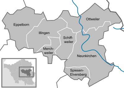

(Population figures as of December 31, 2019)
|
|
Protected areas
There are seven designated nature reserves in the district (as of February 2017).
License Plate
The distinctive sign OTW of the previous district of Ottweiler was issued until February 28, 1974.
On March 1, 1974, the renamed district was assigned the distinctive sign NK , which had been valid since January 1, 1968 for the medium- sized town of Neunkirchen . It is still issued today.
Until the 1990s, vehicles from the city of Neunkirchen received license plates with the letters A to Z and the numbers from 1 to 999 as well as with the letter pairs AA to ZZ and the numbers from 1 to 99. The vehicles from the rest of the district received license plates with the Pairs of letters AA to ZZ and the numbers 100 to 999.
Web links
- Official website of the Neunkirchen district
- Literature on Neunkirchen district in the Saarland bibliography
Individual evidence
- ↑ Saarland.de - Official population figures as of December 31, 2019 (PDF; 20 kB) ( help ).
- ↑ Law on the reorganization of the municipalities and districts of Saarland of December 19, 1973 . In: Saarland Official Gazette . tape 1973 , no. 48 , p. 852 , § 55 Renaming of the district of Ottweiler ( digitized [PDF; 487 kB ]).
- ^ Website "Rosenkreis Neunkirchen" of the tourism and culture center of the district of Neunkirchen
- ↑ Official Journal of the Saar Regional Council , year 1946, No. 47, p. 198: "Order on the administrative organization of the Saar area" from October 1, 1946 ( Saarland University )
- ↑ Law on the reorganization of the municipalities and districts of Saarland of December 19, 1973 . In: Saarland Official Gazette . tape 1973 , no. 48 , p. 852 , § 55 Renaming of the district of Ottweiler ( digitized [PDF; 487 kB ]).
- ^ Federal Statistical Office (ed.): Historical municipality directory for the Federal Republic of Germany. Name, border and key number changes in municipalities, counties and administrative districts from May 27, 1970 to December 31, 1982 . W. Kohlhammer, Stuttgart / Mainz 1983, ISBN 3-17-003263-1 , p. 805 f .
- ^ Contributions to the statistics of the Königl. Prussian Rhineland. 1829, p. 20 , accessed November 11, 2017 .
- ^ Description of the administrative district of Trier. 1849, p. 297 , accessed November 11, 2017 .
- ↑ a b Community encyclopedia for the Kingdom of Prussia 1885
- ↑ a b c d Michael Rademacher: German administrative history from the unification of the empire in 1871 to the reunification in 1990. merzig.html. (Online material for the dissertation, Osnabrück 2006).
- ↑ Statistical Yearbook for the Federal Republic of Germany 1972
- ↑ Statistical Yearbook for the Federal Republic of Germany 1974
- ↑ Statistical Yearbook for the Federal Republic of Germany 1981
- ↑ Statistical Yearbook for the Federal Republic of Germany 1992
- ↑ Statistical Yearbook for the Federal Republic of Germany 2002
- ↑ District elections 2019, LK Neunkirchen, official final result
- ↑ [1]
- ↑ [2]
- ^ Gunther Thomas: District administration presents social report , Saarbrücker Zeitung , November 16, 2011.
- ↑ Future Atlas 2016. (No longer available online.) Archived from the original on October 2, 2017 ; accessed on March 23, 2018 . Info: The archive link was inserted automatically and has not yet been checked. Please check the original and archive link according to the instructions and then remove this notice.
- ↑ Saarland.de - Official population figures as of December 31, 2019 (PDF; 20 kB) ( help ).