Trier district
| Trier district | |
|---|---|
| Inventory period | 1816-1999 |
| Affiliation | 1816–1946 Rhine Province 1946–1999 Rhineland-Palatinate |
| Administrative headquarters | trier |
| Number of municipalities | 557 (1995) |
| surface | 4,922.64 km² (1995) |
| Residents | 503,234 (1995) |
| Population density | 102 inhabitants / km² |
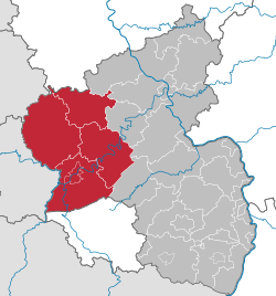
| Location of the administrative district of Trier in Rhineland-Palatinate | |

|
|
The administrative district of Trier was one of the (since 1969) three (previously five) administrative districts of Rhineland-Palatinate and previously one of the Prussian Rhine province . It covered the west of the state of Rhineland-Palatinate. With the restructuring of the state administration on January 1, 2000, the administrative districts were dissolved and the district governments were transferred to the Supervision and Service Directorate (ADD) or Structure and Approval Directorate (SGD) North and South , which are now responsible for certain areas of responsibility throughout the state or Part of the country and are no longer responsible for all tasks within their previous district. Their territorial jurisdiction therefore extends to the whole country in part. The narrower area of responsibility of SGD Nord includes the area of the former Trier administrative district together with the former Koblenz administrative district .
In 1868, on behalf of the Royal Government of Trier, the Saar and Moselle winegrowing map for the Trier administrative district was created under the direction of the Royal Cadastre Inspector Steuerrath Clotten.
From 1955, the seat of the regional council was the baroque Electoral Palace , formerly the residence of the Electors of Trier.
Former administrative division
| in the 19th century (Rhine Province) |
when dissolved in 1999 (Rhineland-Palatinate) |
|
| One district cities | Saarbrücken (since 1909) | (1920 in Saar area) |
| Trier (since 1816) | trier | |
| Counties | Bernkastel |
Bernkastel-Wittlich (since 1969) |
| Wittlich | ||
| Bitburg |
Bitburg-Prüm (since 1970) |
|
| Prüm | ||
| Down | Down | |
| trier |
Trier-Saarburg (since 1969, Saarburg district 1946 partly to Saarland) |
|
| Saarburg | ||
| Merzig | (1920 partly to Saarland, remainder 1946 to Saarland) |
|
| St. Wendel | ||
| Ottweiler | (1920 in Saar area, today Saarland) | |
| Saarbrücken | ||
| Saarlouis |
history


The history of the Trier administrative district goes back to 1816. At that time, after the Congress of Vienna , the Kingdom of Prussia divided its provinces into a total of 25 administrative districts . a. Thus the administrative district of Trier was created within the province of Grand Duchy of Lower Rhine , from 1822 Rhine province . Until after the First World War , today's Saarland (with the exception of the Saarpfalz district and parts of the Sankt Wendel district ) belonged to the Trier administrative district. According to the Versailles Treaty , the Saar area was separated and placed under a League of Nations mandate in 1920, which significantly reduced the population of the Trier administrative district. The Saar area now included Saarbrücken , the districts of Saarbrücken , Ottweiler and Saarlouis as well as parts of two other districts: In Prussia and thus the administrative district of Trier, only the so-called Merzig-Wadern district , which was now located in Wadern, remained of the Merzig district that had come to the Saar area . After the Second World War , the main and remaining districts of Merzig were reunited in 1946 and have belonged to Saarland ever since, where it has been known as the Merzig-Wadern district since 1964 . Similarly, in 1920 from the given to the Saar was district Sankt Wendel the rest of the Kreis Sankt Wendel Baumholder separated, which remained in Trier. This radical group was, however, in the 1937 Koblenz belonging Birkenfeld incorporated.
After the Second World War , the Trier administrative district became part of the State of Rhineland-Palatinate in 1946. Here he was one of the first five administrative districts . The others were Koblenz , Montabaur , Rheinhessen (seat in Mainz ) and Pfalz (seat in Neustadt an der Weinstrasse ). It initially comprised the urban district of Trier and the districts of Bernkastel (today the district of Bernkastel-Wittlich), Bitburg (today the Eifel district Bitburg-Prüm), Daun (today the Vulkaneifel), Prüm (today the Eifel district Bitburg-Prüm), Saarburg (today Trier-Saarburg) , Trier (today Trier-Saarburg) and Wittlich (today the district of Bernkastel-Wittlich). In the event of changes to the state border, in addition to the reclassification of the remaining Merzig-Wadern district to Saarland (see above), further municipalities were established until 1947, primarily from the former Sankt Wendel-Baumholder district, but also from the Oldenburg area of the Birkenfeld district to Saarland connected.
During the district reform that was carried out in Rhineland-Palatinate between 1969 and 1974, the districts were merged into larger administrative units. From 1974 until its dissolution in 2000, the Trier administrative district thus comprised the independent city of Trier and the four districts mentioned above .
District President
The following 30 people were regional presidents of the Trier administrative district:
|
|
See also
Web links
- Administrative district of Trier Administrative history and list of regional presidents on the website territorial.de (Rolf Jehke), as of July 23, 2013.
- Supervision and Service Directorate (ADD)
- Structure and Approval Directorate (SGD) North
- Structure and Approval Directorate (SGD) South
Individual evidence
- ↑ a b c Official municipality directory (= State Statistical Office Rhineland-Palatinate [Hrsg.]: Statistische Bände . Volume 407 ). Bad Ems February 2016, p. 144 (PDF; 2.8 MB).
- ↑ http://www.dilibri.de/rlb/content/titleinfo/100270