
Main-Taunus-Kreis
| coat of arms | Germany map |
|---|---|

|

Coordinates: 50 ° 5 ' N , 8 ° 27' E |
| Basic data | |
| Existing period: | 1928– |
| State : | Hesse |
| Administrative region : | Darmstadt |
| Administrative headquarters : | Hofheim am Taunus |
| Area : | 222.39 km 2 |
| Residents: | 238,558 (Dec. 31, 2019) |
| Population density : | 1073 inhabitants per km 2 |
| License plate : | MTK |
| Circle key : | 06 4 36 |
| NUTS : | DE71A |
| Circle structure: | 12 municipalities |
| Address of the district administration: |
Am Kreishaus 1–5 65719 Hofheim am Taunus |
| Website : | |
| District Administrator : | Michael Cyriax ( CDU ) |
| Location of the Main-Taunus-Kreis in Hessen | |
  |
|
The Main-Taunus-Kreis is a regional authority in the administrative district of Darmstadt in Hesse . The smallest and second most densely populated district in Germany lies in the core of the Rhine-Main area . The Main-Taunus-Kreis is located in the western suburbs of Frankfurt am Main or to the east of the Hessian state capital Wiesbaden and northeast of the Rhineland-Palatinate state capital Mainz . The district town of Hofheim am Taunus has been the most populous city since 1987 . Before that, the seat of the district administration was in Frankfurt-Höchst , which until 1928 was the district seat of the predecessor district Höchst am Main .
The Main-Taunus-Kreis is known for its properties with high rent levels and for the fifth highest purchasing power index of all rural and urban districts in the Federal Republic of Germany . In 2017, the purchasing power index was 132.9 percent of the national average. The cities of Bad Soden am Taunus (176.5 percent) and Kelkheim (Taunus) (143.0 percent) have the highest per capita incomes in the Main-Taunus district. With a purchasing power index of 143.2 percent, the neighboring Hochtaunus district has the second highest per capita income of all rural and urban districts in Germany.
The population in the Main-Taunus-Kreis comes from 154 nations. Around 2300 Koreans live in the district and form the largest Korean community in Germany.
geography
location


The district area stretches from the Main (around 90 m above sea level ) up to the Hohe Taunus . The highest mountain in the district is the 563.3 m high Eichkopf near Kelkheim-Ruppertshain, until the regional reform in Hesse in 1972 the highest mountain in the Taunus , the 881.5 m high Große Feldberg, belonged to the district area.
In addition to the wooded Taunus Mountains, orchards , brook meadows and some agriculturally used areas characterize the undeveloped part of the landscape, but settlement areas and traffic routes dominate the landscape in most of the district.
With the exception of the three cities on the Main count all county municipalities Vordertaunus that reaches up from Hofheim Friedrichsdorf pulling linear city west and north-west of Frankfurt, which is part of the so-called Frankfurt " bacon belt is".
Especially the eastern part of the district is extremely densely populated for a district and belongs to the suburban (suburb) area of the Frankfurt metropolitan area . In Germany there are only a few districts with a similarly metropolitan character, such as the districts of Recklinghausen , Mettmann and Ennepe-Ruhr in the Rhine-Ruhr area , the district of Munich or the district of Offenbach south of Frankfurt. With over a thousand inhabitants per square kilometer, the Main-Taunus district is the district with the second highest population density in Germany.
A comparison of the Main-Taunus district with the neighboring state capital Wiesbaden reveals remarkable parallels . It has a little more area and a little less inhabitants, and the population density of the district is a little lower than in Wiesbaden.
Due to its predominantly middle- class population, the Main-Taunus-Kreis is one of the wealthiest regions in the Federal Republic and, depending on the indicator and year, occasionally takes the top spot nationwide. The residents of Bad Soden have the highest purchasing power in the Main-Taunus district .
Eppstein, Hofheim, Flörsheim and Hochheim are old towns with well-preserved old town centers. Even in pre-industrial times, the abundant soils ensured a relatively high level of prosperity and population density, as can be seen in the old village centers, churches and courtyards.
Neighboring areas
The Main-Taunus-Kreis bordered clockwise to the north, starting with the similarly structured Hochtaunuskreis , the independent city of Frankfurt am Main , the industrialized Groß-Gerau district , the independent state capital Wiesbaden and the Rheingau-Taunus-Kreis .
history


In the Middle Ages, the district area belonged partly to Eppstein , partly to Kurmainz , from 1803 to Nassau-Usingen and from 1806 to the Duchy of Nassau and since the Prussian annexation in 1866 to the province of Hesse-Nassau . The municipalities between Wiesbaden and Frankfurt were initially assigned to the Mainkreis with headquarters in Wiesbaden (Hochheim and Höchst offices), while the existing division into the offices of Hochheim, Höchst, Idstein and Königstein was retained , the municipalities in the Königstein office to the Obertaunuskreis and the office Idstein to the Untertaunuskreis.
When a new Hesse-Nassau district order came into force on April 1, 1886, the province was divided into new, smaller districts and the offices dissolved. Instead of the Main district, the districts of Höchst and Wiesbaden were created .
Due to the population growth in the cities of Frankfurt and Wiesbaden and their surrounding areas, a municipal reorganization of the region became necessary on April 1, 1928. Several communities in the districts of Höchst and Wiesbaden, including the city of Höchst, were incorporated into the neighboring cities. Both counties lost most of their inhabitants. The remaining communities in both districts and some communities from the Obertaunus , Usingen and Untertaunus districts were merged into a new district called Main-Taunus-Kreis .
When it was founded, the district comprised 49 towns and cities. The number fell to 46 in 1938 due to incorporation into Kelkheim and Hofheim. A map of the Main-Taunus district from 1951 shows the six cities and the 40 rural communities with their population.
In 1945 the district changed its state again and became part of the state of Hesse .
During the regional reform in Hesse between 1972 and 1977, the district was changed significantly both at its external borders and in its municipality structure.
On December 31, 1971, the last date of the “voluntary phase” promoted by the state government through increased key allocations, nine district communities joined the cities of Hofheim, Flörsheim, Hattersheim and Eschborn. By merging two neighboring villages each, the three new municipalities Reifenberg (from Niederreifenberg and Oberreifenberg ), Liederbach am Taunus (from Oberliederbach and Niederhofheim ) and Rossert (from Eppenhain and Ruppertshain ) were created.
The municipalities, which were not ready to a voluntary union, were assigned to neighboring cities by a state law on January 1st, 1977. This affected ten old communities and the five-year-old community of Rossert, which with around 2500 inhabitants did not reach the required minimum size. The incorporation of Sulzbach to Bad Soden and from Kriftel to Hofheim, which was decided during the consultation phase, was deleted from the draft law shortly before the state parliament decision, under circumstances that have not yet been clearly clarified. The representatives of the two communities had previously campaigned vehemently to preserve their independence.
The district was also made smaller in 1972 and 1977 by ceding communities to neighboring districts and the independent city of Wiesbaden:
- On August 1, 1972, the community of Glashütten , into which the community of Schloßborn was also incorporated, moved to the Hochtaunuskreis . The municipality of Reifenberg also left the district and was incorporated into Schmitten in the Hochtaunus district.
- On January 1, 1977, the community of Niedernhausen moved to the new Rheingau-Taunus district . The communities of Auringen , Breckenheim , Delkenheim , Medenbach , Naurod and Nordenstadt were incorporated into the independent city of Wiesbaden .
Since the completion of the regional reform, the Main-Taunus-Kreis has twelve municipalities, nine of which are cities. From 1928 the district town and administrative seat was the Frankfurt district Höchst . With effect from 1 January 1980 Hofheim am Taunus determined by law for the seat of the district, but it was not until 1987 with the completion of the new county building moved to Hofheim.
In February 2004, the then District Administrator Jürgen Banzer (CDU) of the neighboring Hochtaunus district discussed a possible merger of the Hochtaunus district with the similarly structured Main Taunus district. Merging the two districts could result in annual savings of 18 to 20 million euros.
The Main-Taunus district declared a disaster on October 9, 2015 because of the short-term admission of up to a thousand refugees . According to District Administrator Michael Cyriax, it is the first time since 1945 that the disaster has been identified in the district. In the opinion of the Hessian Ministry of the Interior, this step was not necessary, the district would have all of the state's funds at its disposal even without the declaration.
Population statistics

| year | Residents | source |
|---|---|---|
| 1933 | 67,415 | |
| 1939 | 71,235 | |
| 1950 | 100.234 | |
| 1960 | 124,500 | |
| 1970 | 187,000 | |
| 1980 | 201,200 | |
| 1990 | 206,400 | |
| 2000 | 220.264 | |
| 2010 | 227.425 | |
| 2015 | 230,868 | |
| 2018 | 237.265 |
Denomination statistics
According to the 2011 census , 27.3% of the population were Protestant , 31.2% Roman Catholic and 41.5% were non-denominational , belonged to another religious community or did not provide any information. The number of Catholics has decreased since then. At the end of 2019, the Main-Taunus-Kreis had around 240,000 people, including 26.8% (64,392) Catholics.
politics
household
In the 2017 budget year, the Main-Taunus-Kreis reported income of 413.749 million euros. This is offset by expenses (expenses) in the amount of 413.793 million euros. The district has 406.873 million euros in debt.
District council
The local elections on March 6, 2016 produced the following results, compared to previous local elections:
| Diagram showing the election results and the distribution of seats | |
|---|---|
|
Election of the district council of the Main-Taunus-Kreis 2016
% 40 30th 20th 10
0
33.7
20.6
14.2
12.7
9.3
5.7
3.8
0.1
n. k.
Gains and losses
|
|
81 members of the district council had to be elected for the legislative period from April 1, 2016 to March 31, 2021. Of 180,077 eligible voters, 94,679 went to the polls. As a result, the turnout rose from 49.9 percent in 2011 to 52.6 percent in 2016.
| Nominations | 2016 | 2011 | 2006 | 2001 | ||||||||
|---|---|---|---|---|---|---|---|---|---|---|---|---|
| Share a | Seats | Share a | Seats | Share a | Seats | Share a | Seats | |||||
| Christian Democratic Union of Germany | CDU | 33.6 | 27 | 41.9 | 34 | 46.2 | 37 | 44.0 | 36 | |||
| Social Democratic Party of Germany | SPD | 20.6 | 17th | 22.6 | 19th | 24.2 | 20th | 28.7 | 23 | |||
| Alliance 90 / The Greens | GREEN | 14.2 | 11 | 21.3 | 17th | 11.2 | 9 | 11.6 | 9 | |||
| Alternative for Germany | AfD | 12.7 | 10 | - | - | - | - | - | - | |||
| Free Democratic Party | FDP | 9.3 | 8th | 5.2 | 4th | 8.2 | 7th | 6.7 | 6th | |||
| Free voter community Main-Taunus-Kreis | FWG | 5.7 | 5 | 4.9 | 4th | 4.6 | 4th | 4.8 | 4th | |||
| Voting community Die Linke Main-Taunus-Kreis | THE LEFT. | 3.8 | 3 | 2.6 | 2 | 2.1 | 2 | - | - | |||
| Main-Taunus citizen | MTB | 0.1 | 0 | - | - | - | - | - | - | |||
| The free citizens | dfb | - | - | 1.5 | 1 | 1.6 | 1 | 1.7 | 1 | |||
| The Republicans | REP | - | - | - | - | 1.7 | 1 | 2.6 | 2 | |||
| total | 100 | 81 | 100 | 81 | 100 | 81 | 100 | 81 | ||||
| Turnout in percent | 52.6 | 49.9 | 47.2 | 55.0 | ||||||||
After the local elections in 2011, the coalition of the CDU and FDP could not be continued because it did not have a majority in the district assembly. Therefore, the coalition was expanded to include the FWG, so that the CDU, FDP and FWG formed a coalition in the district council. In January 2014, two members of the district council from the Green parliamentary group joined the Die Linke community of voters. The background was the formation of a black-green state government in Hesse.
District administrators
| District Administrator | Term of office |
|---|---|
| Wilhelm Apel (SPD) | 1928-1933 |
| Ernst Janke | 1933-1939 |
| Franz Brunnträger (NSDAP) | 1939-1945 |
| Walter Weber | 1945-1946 |
| Joseph Wagenbach (CDU) | 1946-1966 |
| Valentin Jost (SPD) | 1966-1988 |
| Bernward Löwenberg (CDU) | 1978-1989 |
| Jochen Riebel (CDU) | 1990-1999 |
| Berthold R. Gall (CDU) | 1999-2011 |
| Michael Cyriax (CDU) | since October 2011 |
On April 23, 2017, 181,338 citizens in 170 electoral districts were allowed to vote in the Main-Taunus district. The candidates were Michael Cyriax (CDU), Georg Einhaus (SPD) and Fritz-Walter Hornung (left). Michael Cyriax was re-elected with 67.6 percent. The turnout was 28.6 percent.
District Committee

The district committee consists of the district administrator and 15 councilors elected by the district council. District Administrator Michael Cyriax (CDU) has been at the helm since 2011 . Further full-time department heads are the first district member Wolfgang Kollmeier (CDU) and the district member Johannes Baron (FDP). Of the 13 voluntary district members, five belong to the CDU, three each from the SPD and the Greens, and one each from the FDP and the FWG.
Symbols
The Main-Taunus-Kreis has a coat of arms , a hoisting flag and a banner flag . The district administration uses a logo in the media .
coat of arms
On March 30, 1950, after detailed deliberation (with the KPD abstaining ) , the district council approved a submission by the district committee on the use of a district coat of arms. In execution of this resolution and a subsequent resolution of the state government, the Hessian Interior Minister granted the district the right to use the coat of arms by decree of June 19, 1950. The Hessian State Archives contributed to the design of the coat of arms and confirmed the choice of symbols in an expert report.
|
|
Blazon : “In the divided shield , in the upper field in red a wheel in silver . In the lower field in silver three rafters in red. " |
| Reasons for the coat of arms: The wheel is the Mainz wheel , the coat of arms of the archbishops of Mainz . The rafters are the coat of arms of the Lords of Eppstein , whose dominion was largely taken over by Mainz in 1581. Both parties determined the history of the district area. |
flag
In the meeting on September 9, 1955, the district council decided unanimously that the flag should show the coat of arms in a field divided in red and white. The State Archives had reservations about this, so that the district council decided in an amended resolution of November 25, 1955 that the flag should show the coat of arms in a white central strip between two narrow red stripes. The Hessian Minister of the Interior issued a document dated January 30, 1956, authorizing the use of the flag in this form.

logo
The district administration already had a logo before the red “dot” used today. This green “curl” was created around 1987 and its use has since been replaced by the coat of arms. Since the coat of arms was perceived as conservative and not original, the district administration introduced a new logo as a symbol of a modern administration. Since spring 2001 it is z. B. used in cover letters, certificates, press releases, websites, annual reports, information brochures, job advertisements, etc. The logo was designed by the graphic artist Dejan Pavlović and shows the circular, stylized coat of arms with the circle name right next to it. The abstract circular shape should ensure a faster recognition value as well as various design options from afar.
District partnerships
The Main-Taunus-Kreis has maintained a partnership with the English Metropolitan Borough of Solihull in the West Midlands region since 1979 (officially since 1992) . In 2006 another partnership was added with Loudoun County in the US state of Virginia .
economy

Economically, the Main-Taunus-Kreis benefits from its central location and its suburban character. Above all, the service industry ( tertiary sector ) determines the economy of the district. Suburban communities in the east of the district are encouraging companies from Frankfurt to relocate to their urban area through lower trade tax rates .
In this way, Eschborn became the headquarters of important companies, in particular parts of Deutsche Bank , Deutsche Börse and Vodafone . Schwalbach, Sulzbach, Bad Soden and Kriftel also benefit to a considerable extent from commercial suburbanization . The Main-Taunus-Zentrum , the oldest and still one of the largest shopping centers in Germany, is located in Sulzbach . In Eschborn and Hofheim- Wallau there are two large agglomerations of specialist and wholesale stores , which, like the Main-Taunus-Zentrum, are excellently connected to the motorway network, but only modestly connected to local public transport.
To a lesser extent, the district owned and still has industrial operations . Sarotti in Hattersheim has been shut down and partially demolished; the newly built Sarotti-Center , a local supply shopping center, reminds of this in its name. There is a medium-sized furniture industry in Kelkheim . Directly beyond the district boundaries, in Frankfurt-Höchst, Rüsselsheim am Main and the Mainz suburbs on the right bank of the Rhine, there are other large industrial companies, of which Opel in Rüsselsheim is the largest.
Despite the solid economic base, most of the cities in the district are residential communities for commuters , tens of thousands of employees travel to Frankfurt to work every day, and many more to Wiesbaden, Mainz or other cities in the region.
Agriculture and forestry play an increasingly minor role. Agriculture is characterized by orchards that contribute to the production of the famous apple wine . The most famous fruit growing community in the district is Kriftel. In Hochheim , Flörsheim-Wicker and Flörsheim is wine grown. In terms of wine law, these places are part of the Rheingau .

In 2017, the Main-Taunus district recorded the fifth highest purchasing power of all rural and urban districts in the Federal Republic of Germany, at 132.9 percent of the national average. It is noteworthy that all twelve municipalities in the Main-Taunus-Kreis have a purchasing power index that is well above average.
In the Future Atlas 2016 , the Main-Taunus-Kreis took 13th place out of 402 rural districts, municipal associations and independent cities in Germany, making it one of the regions with “very high future prospects”. In the 2019 edition, it was ranked 11th out of 401.
traffic
The district is located in the center of a metropolitan region and is crossed by numerous traffic routes, some of which are of international importance.
Road traffic

For the circle itself and the Wiesbaden-Frankfurt region originally as is the Rhine-Main Schnellweg known motorway A 66 , the main artery. It runs through the district in an east-west direction and connects it with the two neighboring cities and with Mainz . The A 66 is linked to the A 3 and the A 5 via the Wiesbadener Kreuz , Westkreuz Frankfurt and Nordwestkreuz Frankfurt . This means that there are fast connections to Frankfurt Airport on the one hand and on the other hand via the federal trunk road network in all directions.
Apart from the Wiesbaden junction in Hofheim-Wallau highway has A 3 not on the district junction . It runs on the western border and in the south of the district and connects the metropolitan areas in Holland and Rhine-Ruhr with Frankfurt and the south-east of Central Europe.
The B 40 links the A 66 via the A 671 and the Theodor-Heuss-Brücke with Mainz and from the Krifteler Dreieck via the Sindlinger Mainbrücke with Kelsterbach , Frankfurt Airport and the southern districts of Frankfurt.
The A 671 is part of the Mainz motorway ring and is of great importance for the city of Hochheim. The motorway-like B 8 connects the A 66 and Frankfurt-Höchst with Bad Soden, Kelkheim and Königstein im Taunus .
The federal highways B 455 (Wiesbaden – Königstein) and B 519 (Königstein – Rüsselsheim am Main) also run through the district.
Rail transport


A total of seven railway lines run through the small Main-Taunus district. All twelve municipalities have rail connections.
The nationally most important rail route, albeit without a stop in the district, is the high-speed route Cologne – Rhine / Main , which went into operation in 2002 and connects Frankfurt and Cologne in around an hour. It runs largely parallel to the A3 motorway in the form of a traffic route bundling . At Hofheim-Wallau, a branch line of the high-speed line to Wiesbaden branches off from the main line.
The district itself is accessed by railway lines that radiate out from Frankfurt-Höchst train station :
- the S-Bahn lines S1 via Hattersheim, Flörsheim and Hochheim to Mainz-Kastel and Wiesbaden,
- the S2 via Kriftel, Hofheim and Eppstein to Niedernhausen ,
- the Königsteiner Bahn operated by the Frankfurt-Königsteiner Eisenbahn via Liederbach and Kelkheim to Königstein,
- the Sodener Bahn (also FKE) from Frankfurt-Höchst via Sulzbach to Bad Soden.
Two more S-Bahn lines reach the district area from Frankfurt Central Station :
There is also a dense bus network available. The Rhein-Main-Verkehrsverbund (RMV) is based in the district town of Hofheim .
The construction of a ring line, which will link important western suburbs with each other and relieve the transfer hubs in downtown Frankfurt , has been planned since the mid-1990s. Construction is to begin in the next few years and commissioning is scheduled for 2023. The West Regional Tangent is intended to connect the city of Eschborn with Frankfurt-Höchst and Frankfurt Airport.
air traffic
The international airport Frankfurt am Main is only a few kilometers outside the district area and can be reached in a few minutes. This is why airport-related companies have settled in Hattersheim and Kriftel. The district not only has the advantages of being close to the airport: Several municipalities in the district area - in particular the cities of Hattersheim, Hochheim and Flörsheim - are affected by aircraft noise . The extent of the noise is recorded and documented long-term by the German Aircraft Noise Service , which is based in Eppstein .
The Wiesbaden-Erbenheim airfield is located around one kilometer west of the district border and was the subject of specific expansion plans in the 1980s as a possible satellite airport for Rhine-Main. The airfield will continue to be used by the American Air Force , which does not allow civil conversion.
The Frankfurt-Hahn Airport in the state of Rhineland-Palatinate is about a hundred kilometers west of the circle.
Inland shipping
In the Main-Taunus-Kreis there is only one larger inland port , in Flörsheim-Keramag . However, there are other ports in the immediate vicinity, for example in the Höchst industrial park , in Kelsterbach , in the Raunheim industrial area Caltex / Ticona , in the Rüsselsheim Opel factory and in Mainz-Kostheim (district of Wiesbaden).
In the district there are two with locks equipped barrages in the main: the barrages Eddersheim and Ginsheim .
Communities
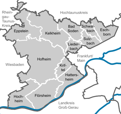

The Main-Taunus-Kreis has twelve communities. District seat and at the same time most populous city is Hofheim am Taunus. A special feature is that nine of them have official additions such as “am Taunus” or “am Main” - so these additions are a binding part of the community name and are always written in full (without abbreviations).
The following lists the twelve municipalities in the Main-Taunus district with their population as of December 31, 2019.
| Commune | Type of commune | Residents | Purchasing power index in percent |
|---|---|---|---|
| Hofheim am Taunus | County seat | 39,647 | 138.5 |
| Kelkheim (Taunus) | city | 29,075 | 143.0 |
| Hattersheim am Main | city | 27,674 | 111.5 |
| Bad Soden am Taunus | city | 22,855 | 176.5 |
| Eschborn | city | 21,609 | 131.6 |
| Flörsheim am Main | city | 21,659 | 110.3 |
| Hochheim am Main | city | 17,945 | 118.1 |
| Schwalbach am Taunus | city | 15,300 | 127.7 |
| Eppstein | city | 13,692 | 130.1 |
| Kriftel | local community | 11,220 | 129.1 |
| Liederbach am Taunus | local community | 8,855 | 128.9 |
| Sulzbach (Taunus) | local community | 9,027 | 135.3 |
The purchasing power indices given in the table refer to the year 2017, with the exception of the information for the city of Hochheim am Main, which refers to the year 2018.
Former parishes
The following list contains all former municipalities of the Main-Taunus-Kreis and the dates of their incorporations or district changes:
License Plate
On July 1, 1956, the district was assigned the distinguishing mark FH . It referred to the then seat of the district administration in the Frankfurt district of Höchst . On January 15, 1980 the district received the new distinctive sign MTK derived from the district name .
Others
There are hospitals in Hofheim and Bad Soden. The Marienkrankenhaus in Flörsheim was purely a private hospital, was closed at the end of 2017 and converted into a specialist center. Emergency rooms are only located in Bad Soden and Hofheim. There are 55 public and six private schools in the district . Seven schools lead to the Abitur , five are special schools , three are vocational schools . The district has 119 day-care centers , 83 sports halls , 40 sports fields , six outdoor and five indoor pools .
The Main-Taunus-Kreis was the first district in Hesse to use the uniform public authority number 115 .
literature
- Michael Nitz, Simone Balsam, Sonja Bonin: Cultural monuments in Hessen: Main-Taunus-Kreis . Ed .: State Office for Monument Preservation Hessen (= Monument Topography Federal Republic of Germany ). 2003, ISBN 978-3-8062-1650-9 .
- Gerd S. Bethke: Main-Taunus-Land: Historical local dictionary . Ed .: Historischer Verein Rhein-Main-Taunus (= wheel and rafter . Volume 26 ). 1996.
- Förderkreis Kunstsammlung Main-Taunus (ed.): Art in architecture: District building of the Main-Taunus district . 1987 (brochure on the art objects in the district building).
- District committee of the Main-Taunus-Kreis (Ed.): Our new house: The district house . September 1987 (brochure on moving into the district building).
- Hans-Joachim Nimtz, Otto Winterwerber: People and Powers: History and Stories between Main and Taunus . Ed .: Kreissparkasse des Main-Taunus-Kreis. Deutscher Sparkassenverlag, Stuttgart 1986, ISBN 3-09-303950-9 (portrait of the Main-Taunus-Kreis).
- Valentin Jost (Ed.): Main-Taunus-Almanach 1967 + 1968 . 1968.
See also
- Main-Taunus constituency
- Route of the industrial culture Rhein-Main Main-Taunus-Kreis
- Route of industrial culture Rhein-Main Hessischer Unterer Main
- List of devastation in the Main-Taunus-Kreis
Web links
- Official website of the Main-Taunus-Kreis
- Main-Taunus-Kreis. Historical local dictionary. In: Landesgeschichtliches Informationssystem Hessen (LAGIS).
- Law on the reorganization of the Main-Taunus-Kreis and the city of Wiesbaden (GVBl. II 330–30) of June 26, 1974 . In: The Hessian Minister of the Interior (ed.): Law and Ordinance Gazette for the State of Hesse . 1974 No. 22 , p. 309 ( online at the information system of the Hessian state parliament [PDF; 1.5 MB ]).
- Link catalog on the topic of Main-Taunus-Kreis at curlie.org (formerly DMOZ )
- Publications about the Main-Taunus-Kreis in the catalog of the German National Library
Individual evidence
- ↑ Hessian State Statistical Office: Population status on December 31, 2019 (districts and urban districts as well as municipalities, population figures based on the 2011 census) ( help ).
- ↑ a b c Frankfurt Chamber of Commerce and Industry in Figures 2017 | 2018. (PDF file) Chamber of Commerce and Industry Frankfurt am Main , p. 5 , accessed on January 31, 2019 .
- ↑ The Main-Taunus-Kreis in Korean and Tigrinya. District councilor Hasse: Integrationswegweiser appears in eight languages. (No longer available online.) In: mtk.org. The District Committee of the Main-Taunus District, August 5, 2016, archived from the original on January 5, 2017 ; Retrieved January 5, 2017 . Info: The archive link was inserted automatically and has not yet been checked. Please check the original and archive link according to the instructions and then remove this notice.
- ↑ Korean medium-sized companies gain a foothold in the MTK. District Administrator Michael Cyriax visited Korean SME Promotion Agency. Main-Taunus-Kreis, March 9, 2016, accessed on January 31, 2019 .
- ↑ The Main-Taunus-Kreis is a South Korean stronghold. Frankfurter Neue Presse , June 27, 2018, accessed on January 31, 2019 .
- ↑ a b Main-Taunus-Kreis. Historical local dictionary. In: Landesgeschichtliches Informationssystem Hessen (LAGIS).
- ^ Home map for the MTK from 1951
- ↑ Law on the reorganization of the Main-Taunus district and the city of Wiesbaden (GVBl. II 330–30) of June 26, 1974 . In: The Hessian Minister of the Interior (ed.): Law and Ordinance Gazette for the State of Hesse . 1974 No. 22 , p. 309 ( online at the information system of the Hessian state parliament [PDF; 1.5 MB ]).
- ↑ Taunuskkreis - Fusion should save up to 20 million euros annually. Frankfurter Allgemeine Zeitung , February 17, 2004, accessed on August 25, 2015 .
- ↑ Main-Taunus-Kreis declares a disaster. Zeit Online, October 9, 2015, accessed on October 10, 2015 : “The Hessian State Ministry of the Interior criticized the decision. "A prior coordination with the Ministry of the Interior has not taken place," said a spokesman for the Hessischer Rundfunk. Even if the disaster had not been declared, the district would have been entitled to the necessary resources such as camp beds or vehicles as well as support from the fire brigade or the technical aid organization. "From here we cannot understand what reasons drove the group to do so."
- ↑ a b c d e f g Michael Rademacher: German administrative history from the unification of the empire in 1871 to the reunification in 1990. maintaunus.html. (Online material for the dissertation, Osnabrück 2006).
- ↑ Statistical Yearbook for the Federal Republic of Germany 1972.
- ↑ Hessian State Statistical Office
- ↑ Population in the administrative districts on September 30, 2010 and population processes in the 3rd quarter of 2010. Hessian State Statistical Office, archived from the original on May 10, 2011 ; accessed on May 31, 2019 .
- ↑ Population in the administrative districts on June 30, 2015 and change in population in the 2nd quarter of 2015. Hessian State Statistical Office, archived from the original on March 24, 2016 ; accessed on May 31, 2019 .
- ↑ The population of the Hessian municipalities on June 30, 2018. Hessisches Statistisches Landesamt; in the web archive.
- ↑ Main-Taunus Kreis Religion , 2011 census
- ↑ Why do you still pay church tax? Statistics 2019 , accessed on July 29, 2020
- ↑ district budget. In: mtk.org. The district committee of the Main-Taunus-Kreis, accessed on April 25, 2017 .
- ↑ Results of the district elections of 2016 and 2011. Hessisches Statistisches Landesamt.
- ^ Hessian State Statistical Office: Results of the district elections of 2011 and 2006
- ^ Results of the district elections of 2006 and 2001. Hessisches Statistisches Landesamt.
- ^ Results of the district elections of 2001 and 1997. Hessisches Statistisches Landesamt.
- ↑ Eight lists for district elections. fr-online.de, December 29, 2015.
- ^ Claudia Horkheimer: New coalition on course. Frankfurter Rundschau , July 16, 2011.
- ↑ Hans Schrönghammer: Greens let Greens despair. ( Memento of the original from January 16, 2014 in the Internet Archive ) Info: The archive link was inserted automatically and has not yet been checked. Please check the original and archive link according to the instructions and then remove this notice. In: Höchst Kreisblatt , January 11, 2014.
- ↑ Bert Worbs: 75 years Main-Taunus-Kreis. Highlights from the history of the district.
- ↑ District election 2017. The district committee of the Main-Taunus district, accessed on April 23, 2017 .
- ↑ Main statutes of the Main-Taunus-Kreis in the version of the 17th amendment of June 6th, 2011 ( Memento of the original of February 14th, 2015 in the Internet Archive ) Info: The archive link was inserted automatically and has not yet been checked. Please check the original and archive link according to the instructions and then remove this notice. (PDF file; 22 kB)
- ↑ Granting of the right to use a district coat of arms to the Main-Taunus district in Frankfurt am Main-Höchst, Reg.-Bez. Wiesbaden from June 29, 1950 . In: The Hessian Minister of the Interior (ed.): State Gazette for the State of Hesse. 1950 No. 26 , p. 244 , point 471 ( online at the information system of the Hessian state parliament [PDF; 1.8 MB ]).
- ↑ a b Symbols of the Main-Taunus-Kreis . In: District Administrator Valentin Jost (Ed.): Main-Taunus-Almanach 1967 + 1968 . 1968, p. 64 .
- ↑ The new logo - a round thing . In: mtk news - newspaper for the employees of the district administration of the Main-Taunus-Kreis . No. 3/2001 . Hofheim am Taunus 2001.
- ↑ Zukunftsatlas 2016. Archived from the original ; accessed on March 23, 2018 .
- ↑ Prognos Future Atlas. Handelsblatt, accessed on December 10, 2019 .
- ↑ Regional Tangent West: The first train is to roll in 2023. In: fnp.de. Frankfurter Neue Presse , March 29, 2017, accessed on April 23, 2017 .
- ↑ aircraft noise. The district committee of the Main-Taunus-Kreis, accessed on April 23, 2017 .
- ↑ Purchasing power 2018. (PDF file) In: ihk-wiesbaden.de. Wiesbaden Chamber of Commerce and Industry , p. 2 , accessed on January 31, 2019 .
Counties: Bergstrasse | Darmstadt-Dieburg | Fulda | Casting | Gross-Gerau | Hersfeld-Rotenburg | Hochtaunuskreis | Kassel (Country) | Lahn-Dill-Kreis | Limburg-Weilburg | Main-Kinzig-Kreis | Main-Taunus-Kreis | Marburg-Biedenkopf | Odenwaldkreis | Offenbach (State) | Rheingau-Taunus-Kreis | Schwalm-Eder district | Vogelsbergkreis | Waldeck-Frankenberg | Werra-Meißner district | Wetteraukreis
Independent cities: Darmstadt | Frankfurt am Main | Kassel | Offenbach am Main | Wiesbaden