
Eddersheim
|
Eddersheim
City of Hattersheim am Main
|
|
|---|---|
 |
|
| Height : | 91 m above sea level NHN |
| Area : | 4.51 km² |
| Residents : | 5023 (June 30, 2016) |
| Population density : | 1,114 inhabitants / km² |
| Incorporation : | July 1, 1972 |
| Postal code : | 65795 |
| Area code : | 06145 |
Eddersheim is a district of Hattersheim am Main in the Main-Taunus district in southern Hesse .
Geographical location
Eddersheim is located on the right northern bank of the Main at an old ford that led to Wüsteneddersheim , today's Mönchhof . The place extends parallel to the Main on a light bank terrace. At an oblique angle to this development line, the buildings along Bahnhofstrasse have developed further to the railway line. Eddersheim borders in the northeast on the Hattersheim district of Okriftel, in the northwest on the Flörsheim district of Weilbach.
history
The oldest surviving written reference in a goods classification as Heddereshem dates from 1145. Even in Roman times there was on Main ford a road connection from the direction of Gross-Gerau on the Mönchhof to the Roman fort in Hofheim am Taunus and parallel to the main running Main Street of Mainz via Hochheim, Flörsheim, Eddersheim, Okriftel and Höchst to Frankfurt. The foundation of Eddersheim at the intersection of these streets can be assumed due to the name ending in -heim around the year 400 AD. It could have been named after the founder, an Adrian or an Ether .
After renewed research in 2014, the first mentioning date 1145 was found in a document that is in the possession of the Würzburg State Archives. The place is named Heddereshem on the 870 year old document .
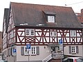
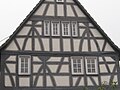
During the Reformation, Lutheran worship was introduced around 1545. After the takeover by Kurmainz in 1581, the place became Catholic again as part of the Counter Reformation in 1604. A number of half-timbered houses from this period are still preserved.
Eddersheim meeting center

Veterinary clinic

Propsteistraße
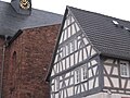
Half-timbered church
Propsteistraße

Ankerstrasse

Propsteistraße
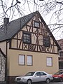
Ankerstrasse

Ankerstrasse


In 1803 Eddersheim went to Nassau-Usingen and at the time of the Duchy of Nassau belonged to the Hochheim office . After the annexation by Prussia in 1867 the Main Circle later and the district Wiesbaden in the administrative district of Wiesbaden assigned.
On the occasion of the regional reform in Hesse , on July 1, 1972, Hattersheim, Okriftel and Eddersheim voluntarily merged to form the new city of Hattersheim (from January 1, 1978 Hattersheim am Main ) through a border change agreement. Since then, independence from the city as a whole has been limited to its own local court .
Culture and sights
Buildings
The church of St. Martin was rebuilt in 1728 and significantly expanded in 1935. You and the since 1332 detected Propsteihof with buildings from the 18th century are the dominant building in the town center. There is also a small chapel in the center of the village.
There is a historic Mönchhof am Main inn near the barrage.

Mönchhof restaurant

St. Martin

chapel


Sports
In 1888 the Eddersheim gymnastics and sports community ( TSG Eddersheim 1888 eV ) was founded. TSG Eddersheim currently consists of four departments, the gymnastics, hiking, table tennis and handball departments.
The handball department makes up the majority of the members and has made itself known far beyond Eddersheim's borders with its active teams and youth work. In the 2011 season, all youth teams, from the minis to the A-youth, were able to play in the male and female areas and some played in the highest classes.
The 1st and 2nd women's teams (3rd League West and District Oberliga Wiesbaden) as well as the 1st and 2nd men's teams (Landesliga Hessen Mitte and District Oberliga Wiesbaden) celebrated several promotions in recent years.
On December 12, 1931, FC Eddersheim was founded by twenty-five members in the Zum Taunus inn . The sports field is located near the barrage.
traffic

Eddersheim is on the L 3006 state road, which runs from Flörsheim am Main in the southwest to Okriftel in the northeast. At the level of the town center, Landesstraße L 3366 branches off from this street as Bahnhofstraße to the west in the direction of Weilbach .
Eddersheim is a station on the S1 line of the Rhein-Main S-Bahn on the Taunus Railway from Wiesbaden Hauptbahnhof via Frankfurt (Main) Hauptbahnhof deep to Rödermark - Ober-Roden . The station was built at the level crossing on Weilbacher Strasse , about halfway between the town centers of Eddersheim and Weilbach.
At the level of the town center, a main barrage was built between 1929 and 1934 with a pedestrian bridge that leads to the way to Mönchhof .
South of Eddersheim, the federal motorway 3 and the high-speed line Cologne – Rhine / Main cross the Main .
Several cycle paths run along the banks of the Main :
- The Hessian long -distance cycle route R3 ( Rhein-Main-Kinzig-Radweg ) leads under the motto In the footsteps of the late rider . along the Rhine , Main and Kinzig via Fulda to Tann in the Rhön .
- The Main Cycle Path leads from the sources of the White and Red Main to Mainz where it flows into the Rhine .
- The D-Route 5 (Saar-Mosel-Main) from Saarbrücken via Trier, Koblenz, Mainz, Frankfurt am Main, Würzburg and Bayreuth to the Czech border (1,021 km).
Personalities
- Anton Flettner (1885–1961), inventor of the Flettner rotor and the Flettner double rotor ; born in Eddersheim
Web links
- Local history Eddersheim. In: Internet presence. City of Hattersheim am Main
- Eddersheim, Main-Taunus-Kreis. Historical local dictionary for Hessen. (As of August 21, 2012). In: Landesgeschichtliches Informationssystem Hessen (LAGIS) ..
- Literature about Eddersheim in the Hessian Bibliography
- State Office for the Preservation of Monuments Hesse (ed.): Complete system in the town center In: DenkXweb, online edition of cultural monuments in Hesse
Individual evidence
- ↑ [LAGIS]
- ^ Hattersheim am Main: Population figures ( Memento from September 15, 2016 in the Internet Archive )
- ↑ Eddersheim too old for the anniversary in FAZ of January 22, 2015, page 39.
- ^ Municipal reform in Hesse: mergers and integrations of municipalities from June 21, 1972 . In: The Hessian Minister of the Interior (ed.): State Gazette for the State of Hesse. 1972 No. 28 , p. 1197 , point 851 para. 1. ( Online at the information system of the Hessian State Parliament [PDF; 4.4 MB ]).
- ^ Federal Statistical Office (ed.): Historical municipality directory for the Federal Republic of Germany. Name, border and key number changes in municipalities, counties and administrative districts from May 27, 1970 to December 31, 1982 . W. Kohlhammer, Stuttgart / Mainz 1983, ISBN 3-17-003263-1 , p. 370 .
- ^ Homepage TSG Eddersheim 1888 eV
- ↑ handball ladies TSG Eddersheim
- ↑ 1st men TSG Eddersheim
- ↑ Football Club Eddersheim on the Internet