
Kinzig (Main)


The Kinzig is a 86 km long river in Hesse , which has its source in Sterbfritz , flows through the Main-Kinzig district and flows into the Main in Hanau . The Kinzig 815 was first mentioned in a document as "Chinzicha".
geography
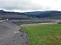
Kinzigquelle
.JPG)
The Kinzig spring lies at the foot of the Steinfirst mountain (512 m) at around 400 m above sea level. NHN near an Aussiedlerhof south of Sterbfritz , a district of Sinntal . It is a small spring set in sandstone with a drainage pipe. The source stream that rises there flows a few meters to the northwest and joins a longer source branch.
course
From the source, the Kinzig initially runs northwest; up to Schlüchtern it is the border between the Hessian Rhön Nature Park and the Hessian Spessart Nature Park . Down from Schlüchtern the Kinzig flows in a south-westerly direction and separates the Vogelsberg in the north from the Spessart in the south. The river runs through the Kinzig reservoir between Steinau and Ahl . On the lower reaches of the Kinzig, canoeists can also navigate.
Shortly before Hanau, the Kinzig flows through the so-called Bulau . This forest area was previously used by the US Army as a training area and is therefore still very natural. At high tide, the forest floodplain quickly becomes full of water through many ditches, so that extensive wild garlic meadows can be found in spring . After about 82 km the river flows into Hanau at about 100 m above sea level. NHN in the Main . There is a viewing platform made up of two nested terrace decks connected by a steel wall, from where you can look out over the Philippsruhe Castle or the Main Harbor, as if from a balcony .
Kinzig dam

The level on the Kinzig

"Kinzigsteg", a wooden bridge over the Kinzig in Bulau near Hanau

One of the ditches with the meadowfoam population


Tributaries
The catchment area of the Kinzig is 1058 square kilometers.
The most important tributaries (over 10 km in length) are:
sorted by length:

enumerated downstream:
- Steinebach ( right )
- Ulmbach ( right )
- Salt ( right )
- Bracht ( right )
- Orb ( left )
- Beaver ( left )
- Birkigsbach ( left )
- Gründau ( right )
- Laugh ( left ) and
- Fallbach ( right ).
A more comprehensive list, which also includes small tributaries, can be found in the list of flowing waters in the Kinzig (Main) river system .
Places on the Kinzig
(in the direction of the river from the source to the mouth, only the places marked in italics are direct residents)
-
Sinntal
- Sterbfritz (source)
- Sannerz
-
Schluechtern
- Full pain
- Herolz
- Schluechtern
- Niederzell
-
Steinau an der Straße
- Steinau
- Bad Soden-Salmünster
-
Waechtersbach
- Neudorf
- Waechtersbach
- Biebergemünd
-
Gelnhausen
- Haitz
- Gelnhausen
- Gründau
-
Langenselbold
- Langenselbold
- Rodenbach (near Hanau)
- Erlensee
-
Hanau
- Hanau (confluence with the Main )
fauna
The following fish species are found in the Kinzig:
Eel , perch , bream , pike , rudd , roach and pikeperch .
Mills
Dying fritz
- Blade mill
- located on the Kinzig
- 1356 named as Hanclingen molendinum .
Sannerz
- Corner mill ( upper mill )
- in the southern local area
- Untermühle (also castle mill )
- at the northern end of the village.
Full pain
- Hammer mill
- Stone mill
- Located on an operating ditch derived from the Kinzig
- Gerlingsmühle
- Located on an operating ditch derived from the Kinzig
Herolz
- Herolz village mill
- in the middle of the village
- Old Mill (Ried Mill)
- approx. 300 m below the town center
Schluechtern
- Hutzelmühle ( Fuldische or walk-mill )
- in front of the shopkeeper
- Mentioned in 1353
- Hildebrandmühle ( mill in Sach , Christenmühle , Kösgen or Kästches mill )
- Monastery mill
- in the courtyard of the former monastery
- Klöbersmühle ( Hofmühle )
- at the lower gate
- Mentioned in 1285
- Richtscheidermühle ( Riedscheider Mill )
- at the southern exit of the village
- Mentioned in 1331
Niederzell
- Townsman Mill
- Located on an operating ditch derived from the Kinzig
- Rose mill
- at an operating ditch derived from the Kinzig
- Mill operations stopped in 1948
Steinau
- Paper mill
- Hop mill
- Fulling Mill
- Herrenmühle
- sawmill
- Neumühle
- Grinder and sawmill
history
The river was already important as a traffic route in Roman times , as the construction of several forts on the lower reaches shows. The place where the Limes crosses the Kinzig near Erlensee-Rückingen was secured by the Rückingen fort . Since the Romans preferred to transport heavy loads with smaller ships or even rafts through towing , a considerable part of the building material and supplies for the eastern Wetterau line was probably handled in Rückingen south of the fort . The Kesselstadt fort , one of the largest known fort buildings on the Limes, was located in the immediate vicinity of the river mouth, but it probably only existed for a short time. It was replaced by the Salisberg fort , which stood nearby on a slight elevation above the Kinzig and the mouth of the Salisbach .
In the Middle Ages , the Kinzig played an important role in securing the country through castles, in particular the Pfalz Gelnhausen , which was surrounded by the Kinzig. Probably also in the time of Friedrich Barbarossa other castle foundations in the region fall, at the Kinzig itself the city castle Hanau and the moated castle in Rückingen , which are mentioned for the first time in 1234 and 1248; however, both should have existed a little longer. In 1405 King Ruprecht of the Palatinate had the moated castle in Rückingen destroyed along with some other castles in the region because of attacks on merchants.

There is clear evidence of shipping on the Kinzig in the Middle Ages, particularly from Gelnhausen. In addition to the name of the ship's gate, which probably belongs to the earliest city complex around 1170, there was also a ship's guild and ship rules. The latter still existed in the 16th century, but was then abandoned because of the construction of mills or the silting of the river. However, shipping was only conducted down the valley, which made the business unprofitable in the long run.
The city of Hanau developed around the castle between the Kinzigarmen in Hanau , residence of the Lords and Counts of Hanau . Before it flows into the Main, the Kinzig encloses the city in an arc to the northwest, which in modern times has favored the construction of polygonal fortifications in the old and new towns. After the demolition of the fortifications in 1806, most of the city moats and Kinzigarmen running through the city were filled in. Of these, only one arm has been preserved, which flows through the Hanau palace garden .
In 1601/02 the Isenburg Count Wolfgang Ernst zu Ysenburg and Büdingen and Philipp Ludwig II. Von Hanau once again made joint efforts to make the Kinzig navigable by building weirs and locks. The Ysenburger hoped for a possible removal of wood on the waterway from the Büdinger forest and for income through a water tariff. Philipp Ludwig von Hanau was interested in improving the traffic connections in his new town Hanau , which was built in 1597 and where he had settled Calvinist religious refugees from the Spanish Netherlands and France. The project failed because of the resistance of the city of Frankfurt and Kurmainz , who intervened with Emperor Rudolf II .
On October 30 and 31, 1813, the battle of Hanau took place immediately north of the Kinzig . A memorial stone on the Kinzigbrücke west of the Hanau suburb commemorates the wounding of the Bavarian general Carl Philipp von Wrede .
traffic
The Kinzig valley between the mountains of Vogelsberg and Spessart has been an important traffic connection for both east-west and north-south traffic since the Middle Ages, as the nickname of Steinau an der Straße attests to. Here a section of the Via Regia or Hohen Straße ran from Mainz via Frankfurt am Main to Leipzig and Breslau . Today the federal highway 66 follows the Kinzig valley axis up to Schlüchtern, it has replaced the former federal highway 40 . The federal highway 276 , which runs from north to south, crosses the valley there, and the Vogelsberger Südbahnradweg runs largely parallel to it from Hartmannshain to Wächtersbach. The Kinzig Valley Railway (Hessen) is used for rail traffic from Frankfurt to Fulda .
See also
literature
- Willi Klein: On the history of milling in the Main-Kinzig district. Published by the Hanauer Geschichtsverein 1844 eV and the Wetterauische Gesellschaft für der Naturkunde zu Hanau, founded 1808 eV , Hanau 2003, ISBN 3-935395-02-7 (= Hanauer Geschichtsblätter 40 ).
- Kurt Lotz: The history of the earth or geology of the Hessian Kinzig valley. Dausien, Hanau 1983, ISBN 3-7684-6359-1 .
Web links
- Retention register for the Kinzig river basin (PDF 1.62 MB)
- Level near Hanau on the HLUG side
- Water profile and program of measures 2478.1 ( Memento from January 1, 2013 in the web archive archive.today ) ( Notes ) → Overview of all Hessian river systems (PDF, 1.7 MB) Untere Kinzig
- Water profile and program of measures 2478.3 ( Memento from January 1, 2013 in the web archive archive.today ) ( Notes ) → Overview of all Hessian river systems (PDF, 1.7 MB) Obere Kinzig
- The Kinzig becomes barrier-free: fish can migrate again . FRI , August 7, 2009, Alexander Polaschek
Individual evidence
- ↑ a b c d e Topographic map 1: 25,000 and WFD database
- ↑ Hanau gauge , Water Science Yearbook 2011, Hessian State Office for Nature Conservation, Environment and Geology
- ↑ Statistics Hanau / Kinzig , Bayerischer Hochwassernachrichtendienst (accessed on September 6, 2013)
- ↑ Master data Hanau / Kinzig
- ↑ Hanau gauge value increased by the drainage of the remaining catchment area (137.08 km²), determined from the data from the Rück , Hainstadt , Goldbach , Harreshausen , Alzenau , Hanau , Kleinheubach and Frankfurt a. M. Osthafen
- ↑ Kinzig , my-bite
- ↑ Martin Eckoldt: Shipping on small rivers in Central Europe in Roman times and the Middle Ages. Writings of the German Maritime Museum 14, Oldenburg, Hamburg, Munich 1980 pp. 84–86.
- ↑ Jürgen Ackermann: 1601/02: Goods transport on the Kinzig or on the Frankfurt-Leipziger Landstrasse? In: Büdinger Geschichtsblätter 18, 2004/2005, pp. 341–344.