
Bieber (Kinzig)
| Beaver | ||
.JPG) The beavers in Kassel |
||
| Data | ||
| Water code | DE : 247854 | |
| location |
Spessart
|
|
| River system | Rhine | |
| Drain over | Kinzig → Main → Rhine → North Sea | |
| source | southeast of Biebergemuend -Röhrig 50 ° 8 '39 " N , 9 ° 21' 29" O |
|
| Source height | approx. 313 m above sea level NHN | |
| muzzle | at Biebergemünd- Wirtheim in the Kinzig coordinates: 50 ° 13 '27 " N , 9 ° 15' 54" E 50 ° 13 '27 " N , 9 ° 15' 54" E |
|
| Mouth height | approx. 136 m above sea level NHN | |
| Height difference | approx. 177 m | |
| Bottom slope | approx. 11 ‰ | |
| length | 16.8 km | |
| Catchment area | 81.21 km² | |
| Discharge at the Kassel A Eo gauge : 79.9 km² Location: 1.7 km above the mouth |
NNQ (08/09/2004) MNQ MQ Mq MHQ HHQ (01/02/2003) |
97 l / s 186 l / s 755 l / s 9.4 l / (s km²) 11.1 m³ / s 25.4 m³ / s |
| Left tributaries | Haßbach , Schwarzbach , Großer Roßbach , Kleiner Roßbach , Lützelbach , Haitzbach | |
| Right tributaries | Obermüllerbach , Untermüllerbach , Sellbach , Elsebach , Büchelbach , Kasselbach | |
 The Bieber (front left) flows into the Kinzig |
||
The Bieber is an almost seventeen kilometer long left and southern tributary of the Kinzig in the Main-Kinzig district in the Hessian Spessart .
geography
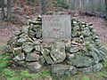
Alexander Scharff source

The Bieber spring is located southeast of Biebergemünd- Röhrig. The creek used to arise from the Große Bieberquelle , which has been known as the Alexander Scharff spring since 1876 and, together with twelve other springs in the Spessart , including the Frankfurt spring located next door (previously Kleine Bieberquelle ), today feeds into the drinking water supply of Frankfurt am Main . These two springs no longer have an above-ground drain to the Bieber, so that today it rises a few meters down the valley in wet meadows . At times the overflows from some other sources also feed the young stream. After heavy rain or snowmelt , the stream emerges further up the valley. The bed of the then water-bearing upper course is led around the drinking water sources and flows from the right into the usual course of the Bieber.
course
About 500 m after its source is Bieber from many water-rich Obermuller Bach strengthened. In the further course it runs through the municipality of Biebergemünd with its districts Bieber , Roßbach , Lanzingen and Kassel . This is where it receives its largest tributary, the Kasselbach . The Bieber flows into the Kinzig near the district of Wirtheim .
Tributaries
- Obermüllerbach ( right ) ( 0.3 km )
- Haßbach ( left ) ( 1.1 km )
- Untermüllerbach ( right ) ( 1.0 km )
- Sellbach ( right ) ( 0.8 km )
- Elsebach ( right ) ( 0.5 km )
- Büchelbach ( right ) ( 1.0 km )
- Schwarzbach ( left ) ( 3.4 km )
- Großer Roßbach ( left ) ( 2.6 km )
- Kleiner Roßbach ( left ) ( 2.0 km )
- Lützelbach ( left ) ( 5.8 km )
- Kasselbach ( right ) ( 6.9 km )
- Haitzbach ( left ) ( 1.9 km )
Kinzig river system
Character and dates
The Bieber is a silicate mountain stream rich in fine material . Its catchment area is 81.21 km² and its mean discharge (MQ) is 809 liters per second. The ecological condition of the stream is assessed as moderate.
biosphere
In the area of Bieber among others come brook lamprey , bullhead and dippers before.
Drinking water sources

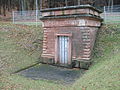
In the catchment area of the Bieber there are several sources of drinking water that feed into the drinking water supply of Frankfurt am Main . They are located in Biebergrund and Kasselgrund in an area of 29 hectares . The spring catchments were built in 1874. They were grown on the red sandstone rocks several meters below the surface . The water that rises there is brought together in a vaulted well chamber, from which two pipes lead off; the usual drainage pipe leads the spring water to the collecting chambers, the drainage pipe drains any cloudy or excess water from the well chamber into the valley. The socket systems are accessible for maintenance work via an entrance door, behind which a staircase leads down to the antechamber. To protect the spring water from pollution, additional iron doors prevent access to the well chambers and antechambers.
A 1.8 m wide and high gallery connects all drinking water sources. A 600 mm thick pipe runs through it on the side. The tunnels are everywhere at least two meters underground and can be walked along their entire length. Inspection accesses for cleaning and maintenance as well as overflow chambers are set up every few hundred meters . This approximately ten kilometer long cast iron pressure pipe crosses under the Kinzig after the processing plant on the Gieserborn by means of a culvert and ends at the collecting tank on the Aspenhainer Kopf near Neu-Wirtheim . There the Spessart drinking water is combined with the water from the Vogelsberg springs. A maximum of about 100 l / s flow through the pressure pipe of the Spessart springs.
The drinking water sources are in the "Spessart extraction area" (in brackets the average discharge ):
- Alexander Scharff source (12 l / s)
- Source Frankfurt (1.3 l / s)
- Glasborn (8.7 l / s)
- Obermüller (20.5 l / s)
- Untermüller (2.1 l / s)
- Dachsborn (5.2 l / s)
- Steinborn
- Mountain spring
- Elsebach
- Hummelsborn (9.2 l / s)
- Casselgrund (1.2 l / s)
- Langenborn (0.4 l / s)
- Wide Ruhborn (18.3 l / s)
- Gieserborn (10.7 l / s)
- Rinneborn
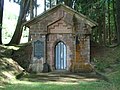
Alexander Scharff source
Source Frankfurt
Glasborn

Obermüller

Untermüller

Dachsborn

Elsebach

Casselgrund

Broad calm spring

Langenborn

Gieserborn

Rinneborn


.JPG)


.JPG)
.JPG)

history
The Bieber was not always a purely Hessian river. After the reorganization of the borders in this area, as a result of the Congress of Vienna , it flowed partly on Bavarian soil from 1814 to 1868. During this time she left the Electorate of Hesse north of Lanzingen (Amt Bieber) and reached the Kingdom of Bavaria ( District Office Gemünden am Main ). From there to its mouth, the Bieber ran on what was then Bavarian territory. After the military defeat in the German War , Bavaria had to surrender the administrative area of the old Orb district court to Hessen-Nassau .
See also
literature
- Christoph Poch, Andreas Herz: The Hessian Spessart waters on the way to Europe. In: District Committee of the Main-Kinzig District (ed.): Mitteilungsblatt Zentrum für Regionalgeschichte 40, 2015, pp. 14-19.
Web links
- Hessian State Office for Environment and Geology: retention cadastre, river area Bieber (Main-Kinzig-Kreis) - river area code number: 247854 (PDF; 2.64 MB) ( Notes )
- Water profile and program of measures 247854.1 ( Memento from January 1, 2013 in the web archive archive.today ) ( Notes ) → Overview of all Hessian river systems (PDF, 1.7 MB) Bieber
Individual evidence
- ↑ Water map service of the Hessian Ministry for the Environment, Climate Protection, Agriculture and Consumer Protection ( information )
- ↑ Kassel level outflow
- ↑ The spaces of drinking water and their environment
- ^ According to the corridor and source name Obermüller in the Hessenviewer of the Hessian State Office for Soil Management and Geoinformation with property mapping
- ↑ a b c d Hessenviewer (Geoportal Hessen) of the Hessian State Office for Soil Management and Geoinformation with property mapping ( notes )
- ↑ Umweltbundesamt (Ed.): Texts 34/2008: EC Water Framework Directive - Harmonization of reporting on ecological classification in accordance with the EC Water Framework Directive (intercalibration of biological test methods in Germany) . ISSN 1862-4804 , ( PDF; 1.3 mb )
- ↑ Ökobüro Gelnhausen GbR ( Memento from May 4, 2006 in the Internet Archive )
- ^ Working group dipper in the NABU district association Main-Kinzig
- ^ Architects and Engineers Association: Frankfurt und seine Bauten BoD - Books on Demand, 2012
- ↑ Topographical Atlas of the Kingdom of Baiern this side of the Rhine Sheet: 10. Orb