
Untermüllerbach
| Untermüllerbach | ||
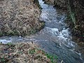
 The Untermüllerbach east of Röhrig |
||
| Data | ||
| location | Main-Kinzig district (Hesse) | |
| River system | Rhine | |
| Drain over | Bieber → Kinzig → Main → Rhine → North Sea | |
| source | southwest of Villbach 50 ° 9 ′ 30 ″ N , 9 ° 22 ′ 53 ″ E |
|
| Source height | 340 m above sea level NHN | |
| muzzle | southeast of Röhrig in the Bieber coordinates: 50 ° 9 ′ 10 ″ N , 9 ° 22 ′ 24 ″ E 50 ° 9 ′ 10 ″ N , 9 ° 22 ′ 24 ″ E |
|
| Mouth height | 270 m above sea level NHN | |
| Height difference | 70 m | |
| Bottom slope | 70 ‰ | |
| length | 1 km | |
| Catchment area | 1.9 km² | |
The Untermüllerbach is a right tributary of the Bieber in the Main-Kinzig-Kreis in the Hessian Spessart .
geography
course
The Untermüllerbach rises southwest of Villbach at the foot of the knoll (430 m) at the Untermüller drinking water tunnel. Today this spring no longer has an above-ground drain to the Untermüllerbach. The Untermüllerbach flows in a south-westerly direction, crosses under the federal highway 276 and joins the Bieber south-east of Röhrig from the right .

The Untermüller drinking water tunnel
The Untermüllerbach (left) flows into the Bieber (from back to front)


Kinzig river system
See also
Web links
Commons : Untermüllerbach - Collection of images, videos and audio files
Individual evidence
- ↑ a b c Google Earth
- ↑ Water map service of the Hessian Ministry for the Environment, Climate Protection, Agriculture and Consumer Protection ( information )
- ↑ Hessenviewer (Geoportal Hessen) of the Hessian State Office for Soil Management and Geoinformation with property mapping ( information )