Riedbach (Reichenbach)
| Riedbach | ||
|
The Riedbach in Birstein |
||
| Data | ||
| Water code | DE : 2478464 | |
| location | Main-Kinzig district (Hesse) | |
| River system | Rhine | |
| Drain over | Reichenbach → Bracht → Kinzig → Main → Rhine → North Sea | |
| source | south of Völzberg 50 ° 26 ′ 25 ″ N , 9 ° 17 ′ 51 ″ E |
|
| Source height | 470 m above sea level NHN | |
| muzzle | in Birstein in den Reichenbach Coordinates: 50 ° 20 ′ 52 ″ N , 9 ° 18 ′ 31 ″ E 50 ° 20 ′ 52 ″ N , 9 ° 18 ′ 31 ″ E |
|
| Mouth height | 260 m above sea level NHN | |
| Height difference | 210 m | |
| Bottom slope | 18 ‰ | |
| length | 12 km | |
|
The Riedbach (behind) flows into the Reichenbach (from right to left) |
||
The Riedbach is one of the largest tributaries of the Reichenbach in Vogelsberg in the Main-Kinzig district in Hesse .
geography
course
The Riedbach rises in a wooded area south of Völzberg . It flows in a southerly direction, divides the villages of Kirchbracht and Mauswinkel and takes in the tributary of the same name at Fischborn , which carries about the same amount of water. In Birstein , the Riedbach flows into the less arid and only about 6 km long Reichenbach after 12 km.
Tributaries
- Steinbach ( right )
- Steinbach ( left )
- Fischborn ( left )
Kinzig river system
Drinking water sources
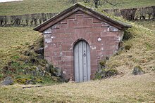
In the catchment area of the Riedbach there are several sources of drinking water that feed into the drinking water supply of Frankfurt am Main . They are located in an area of 19.5 hectares . The spring catchments were built in 1874. They were grown on the basalt rock at a depth of several meters. The spring water is discharged through a cast iron pressure pipe and directed to the collecting tank on the Aspenhainer Kopf near Neu-Wirtheim . There the Vogelsberg drinking water is combined with the water from the Spessart springs.
The drinking water sources are located in the "Vogelsberg extraction area" (the average discharge in brackets ):
- Aderweiher (5.5 l / s)
- Old lake (27.0 l / s)
- Wehmersborn (9.9 l / s)
- Upper & lower floodplain (28.0 l / s)
- Adlerborn (25.6 l / s)
- Lohfinksquelle (6.0 l / s)
Web links
Individual evidence
- ↑ a b Google Earth
- ↑ Hessenviewer (Geoportal Hessen) of the Hessian State Office for Soil Management and Geoinformation with property mapping ( information )
- ^ Architects and Engineers Association: Frankfurt und seine Bauten BoD - Books on Demand, 2012


