Büchelbach (Bieber)
| Büchelbach | ||
|
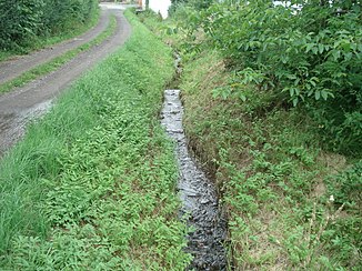
The Büchelbach in Büchelbach |
||
| Data | ||
| Water code | DE : 247854194 | |
| location |
Hessian-Franconian mountainous region
|
|
| River system | Rhine | |
| Drain over | Bieber → Kinzig → Main → Rhine → North Sea | |
| source | northwest of Gassen 50 ° 10 ′ 6 ″ N , 9 ° 20 ′ 16 ″ E |
|
| Source height | 280 m above sea level NHN | |
| muzzle | in Büchelbach in the Bieber coordinates: 50 ° 9 ′ 38 ″ N , 9 ° 20 ′ 7 ″ E 50 ° 9 ′ 38 ″ N , 9 ° 20 ′ 7 ″ E |
|
| Mouth height | 225 m above sea level NHN | |
| Height difference | 55 m | |
| Bottom slope | 55 ‰ | |
| length | 1 km | |
| Catchment area | 2 km² | |
The Büchelbach is a right tributary of the Bieber in the Main-Kinzig-Kreis in the Hessian Spessart .
geography
course

The Büchelbach (behind) flows into the Bieber
The Büchelbach rises at an altitude of about 280 m above sea level. NHN at the edge of the forest northwest of Gassen .
It runs south to Büchelbach , where it finally reaches an altitude of about 225 m above sea level. NHN and flows into the Bieber from the right .
Its approximately 1 km long run ends about 55 meters below its source, so it has a mean bed gradient of about 55 ‰.
Kinzig river system
See also
Web links
Commons : Büchelbach (Bieber) - Collection of images, videos and audio files
Individual evidence
- ↑ a b c Google Earth
- ↑ Water map service of the Hessian Ministry for the Environment, Climate Protection, Agriculture and Consumer Protection ( information )
- ↑ Hessenviewer: High zoom level
