Klingbach (Kinzig)
| Klingbach | ||
|
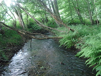
The Klingbach near Salmünster |
||
| Data | ||
| Water code | DE : 247832 | |
| location |
Spessart
|
|
| River system | Rhine | |
| Drain over | Kinzig → Main → Rhine → North Sea | |
| source | in the Spessart estate, northwest of Bad Soden-Salmünster -Mernes | |
| Source height | approx. 320 m above sea level NHN | |
| muzzle | at Salmünster in the Kinzig coordinates: 50 ° 16 '30 " N , 9 ° 21' 33" E 50 ° 16 '30 " N , 9 ° 21' 33" E |
|
| Mouth height | approx. 160 m above sea level NHN | |
| Height difference | approx. 160 m | |
| Bottom slope | approx. 19 ‰ | |
| length | approx. 8.6 km | |
| Catchment area | 27.275 km² | |
| Discharge A Eo : 27.275 km² at the mouth |
MQ Mq |
293.9 l / s 10.8 l / (s km²) |
|
The left arm of the Klingbach (back right) flows into the Kinzig (from left to right) |
||
The Klingbach , locally also the Klingbach , is a good eight and a half kilometers long left and southeastern tributary of the Kinzig in the Main-Kinzig district in the Hessian Spessart .
geography
course
The Klingbach rises in a wooded area in the Spessart estate , northwest of Bad Soden-Salmünster -Mernes. Its flow direction northwest , it retains essentially to the mouth. Almost his entire run he is accompanied by the Spessartstrasse . After about 800 m the Haselsgraben flows towards it. The Klingbach flows to the left of Haselrain and Steinküppel . There it is fed from the room ditch . It flows through three small ponds and then a nature reserve . Shortly before the stream leaves the forest, the death block ditch and the black ditch flow towards it. After flowing through another pond, the stream changes its course into a meadow landscape . There it is reinforced by the Heidegraben . The Mühlbach branches off south of Hausen . The Klingbach now flows between the villages of Hausen and Salmünster and then passes under the A 66 . It flows through Salmünster and finally flows north of Münsterberg-Straße into Kinzig .
Tributaries
- Haselsgraben ( right ), 0.8 km
- Zimmergraben ( right ), 1.4 km
- Death block ditch ( right ), 1.5 km
- Schwarzer Graben ( left ), 1.8 km
- Heidegraben ( right ), 1.0 km
- Hirschbach ( left ), 1.5 miles
Kinzig river system
places
The Klingbach flows through the following villages:
- Bad Soden-Salmünster -Hausen
- Bad Soden-Salmünster-Salmünster
Dates and character
The Klingbach is a body of water III. Order and belongs to the silicate mountain streams rich in fine material . Its mean discharge (MQ) is 293.9 l / s. The catchment area of the Klingbach lies in northern Spessert and covers an area of 27,275 km². While the catchment area on the upper reaches mainly consists of forest areas, the lower reaches are characterized by meadows and urban areas.
history
The Klingbach was not always a purely Hessian brook. After the reorganization of the borders in this area as a result of the Congress of Vienna , it flowed partly on Bavarian soil from 1814 to 1868. From its source to the southeast of Salmünster , the Klingbach ran on what was then Bavarian territory. During this time he left the Kingdom of Bavaria ( District Office Gemünden am Main ) and reached the Electorate of Hesse (Office Salmünster). After the military defeat in the German War , Bavaria had to surrender the administrative area of the old Orb district court to Hessen-Nassau .
See also
literature
- Christoph Poch, Andreas Herz: The Hessian Spessart waters on the way to Europe. In: District Committee of the Main-Kinzig District (ed.): Mitteilungsblatt Zentrum für Regionalgeschichte 40, 2015, pp. 14-19.
Web links
- Hessian State Office for Environment and Geology: Retention cadastre for the Klingbach river basin (PDF file; 1.16 MB)
- Klingbach profile
Individual evidence
- ↑ Water map service of the Hessian Ministry for the Environment, Climate Protection, Agriculture and Consumer Protection ( information )
- ↑ Topographical Atlas of the Kingdom of Baiern this side of the Rhine Sheet: 10. Orb

