Auerbach (Kinzig)
| Auerbach | ||
|
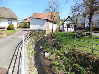
The Auerbach in Niederzell |
||
| Data | ||
| Water code | DE : 24781516 | |
| location |
Hessian-Franconian mountainous region
|
|
| River system | Rhine | |
| Drain over | Kinzig → Main → Rhine → North Sea | |
| source | south of Schlüchtern - Hohenzell 50 ° 18 ′ 11 ″ N , 9 ° 32 ′ 33 ″ E |
|
| Source height | approx. 428 m above sea level NHN | |
| muzzle | near Schlüchtern - Niederzell in the Kinzig coordinates: 50 ° 19 ′ 46 ″ N , 9 ° 29 ′ 57 ″ E 50 ° 19 ′ 46 ″ N , 9 ° 29 ′ 57 ″ E |
|
| Mouth height | approx. 191 m above sea level NHN | |
| Height difference | approx. 237 m | |
| Bottom slope | approx. 45 ‰ | |
| length | approx. 5.3 km | |
| Catchment area | 7.5 km² | |
The Auerbach is a five kilometer long left and south tributary of the Kinzig in the Main-Kinzig district in the Hessian Spessart .
geography
course

The Auerbach rises from the Schwarzen Born at an altitude of about 428 m above sea level. NHN south of Schlüchtern - Hohenzell .
It flows in a north-westerly direction and finally flows into the Schlüchtern district of Niederzell at an altitude of about 191 m above sea level. NHN from the left into the Kinzig .
The approximately 5.3 km long course of the Auerbach ends 237 meters below its source, so it has an average bed gradient of about 45 ‰.
Catchment area
The catchment area of the Auerbach lies in the Schlüchtern basin, a sub-area of the Sandstone Spessart, and is drained to the North Sea via the Kinzig, Main and Rhine rivers.
The catchment area on the lower reaches is characterized by fields and meadows, on the middle course it is predominantly forested and in the estuary area dominated settlements.
