Lache (Kinzig)
|
Lache (upper course: Rodenbach ) |
||
|
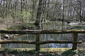
Typical river course in the Bulau between Hanau and Erlensee |
||
| Data | ||
| Water code | DE : 247872 | |
| location |
Rhine-Main lowlands
|
|
| River system | Rhine | |
| Drain over | Kinzig → Main → Rhine → North Sea | |
| source | on the western slopes of the Spessart , southeast of Rodenbach -Oberrodenbach 50 ° 7 '35 " N , 9 ° 4' 28" O |
|
| Source height | 225 m above sea level NHN | |
| muzzle | east of Hanau in the Kinzig coordinates: 50 ° 8 ′ 12 " N , 8 ° 58 ′ 25" E 50 ° 8 ′ 12 " N , 8 ° 58 ′ 25" E |
|
| Mouth height | 107 m above sea level NHN | |
| Height difference | 118 m | |
| Bottom slope | approx. 9.8 ‰ | |
| length | approx. 12 km | |
| Catchment area | 20.08 km² | |
| Drain |
MQ |
138 l / s |
The pool is a good 12 km long, left-hand or southeastern tributary of the Kinzig in the Main-Kinzig district in Hesse . From the source to below the village of Niederrodenbach, it bears the name Rodenbach .
Surname
There is a legend about the origin of the name Rodenbach.
“Once the emperor ( Friedrich Barbarossa ) moved the current Birkenhainer Straße with a weak entourage to get to Mainz. Then it came to pass that not far from the brook, which is now called Rodenbach, a crowd of his enemies - for these he did not lack because he was relentlessly strict against the priests and robber barons - had ambushed him and attacked him and his companions. As bravely as he defended himself with his surroundings, they would have had to succumb to the superior force had it not been for the inhabitants of the high Mark, as the area around Alzenau was then called, rushing to his aid. So his enemies were driven to flight and so many of them were slain that their blood stained the water of the brook red, from which it was named Rothenbach, which later became Rodenbach. "
geography
course
The Rodenbach rises southeast of Oberrodenbach on the western foothills of the Hessian Spessart . It initially flows roughly in a west-northwest direction through the two districts of Ober- and Niederrodenbach, municipality of Rodenbach . To the west of Niederrodenbach it enters the Bulau alluvial forest . From here on, the Rodenbach is referred to as a pool . The separation has only appeared on official maps since 1956 and is probably due to an error. In older works, only various tributaries and oxbow lakes of the Kinzig were referred to as Lachen.
Due to the low gradient and the slow flow speed, the stream divides into several strongly meandering arms on the lower course, which strive towards the Kinzig. It passes some well-preserved sections of the Upper German-Raetian Limes and finally flows into the Kinzig west of the Hanauer Kreuz ( A 45 / A 66 ).
Localities
The localities at the Lache / am Rodenbach are:
- Oberrodenbach
- Niederrodenbach
- Erlensee- Rückingen
- Hanau
Kinzig river system
Dates and character
The pool is a silicate low mountain stream. Their above-ground catchment area covers an area of 2,008.31 hectares. The upper and middle reaches have a slightly agitated relief and are determined by forests, meadows and pastures. In the lower reaches the pool flows through a larger contiguous alluvial forest area. The mean discharge (MQ) is 138 l / s.
literature
- Johannes Koltermann: The pool and the stream on which Ober- and Niederrodenbach lie. (Miszelle) in: Hanauer Geschichtsblätter 18, 1962 p. 248.
- Northwest German Forest Research Institute and Hessen Forest (Hrsg.): Portrait of Hessian natural forest reserves. Kinzigaue. Göttingen 2012, ISSN 2191-107X.
- Christoph Poch, Andreas Herz: The Hessian Spessart waters on the way to Europe. In: District Committee of the Main-Kinzig District (ed.): Mitteilungsblatt Zentrum für Regionalgeschichte 40, 2015, pp. 14-19.
Web links
- Hessian State Office for Environment and Geology: Retention cadastre Lache / Rodenbach river area (PDF; 2.5 MB)
- Water profile and program of measures 247872.1 ( Memento from January 1, 2013 in the web archive archive.today ) ( Notes ) → Overview of all Hessian river systems (PDF, 1.7 MB) Lache / Rodenbach
Individual evidence
- ↑ a b c d Water map service of the Hessian Ministry for the Environment, Climate Protection, Agriculture and Consumer Protection ( information )
- ↑ Johann Georg Theodor Grasse: Book of legends of the Prussian State, Volume 2.
- ↑ J. Koltermann: The pool and the brook on which Ober- and Niederrodenbach lie. (Miszelle) in: Hanauer Geschichtsblätter 18, 1962 p. 248.
