
Okriftel
|
Okriftel
City of Hattersheim am Main
|
|
|---|---|
 |
|
| Height : | 91 m above sea level NHN |
| Area : | 4.06 km² |
| Residents : | 6989 (December 31, 2015) |
| Population density : | 1,721 inhabitants / km² |
| Incorporation : | July 1, 1972 |
| Postal code : | 65795 |
| Area code : | 06190 |
Okriftel is a district of Hattersheim am Main in the Main-Taunus district in southern Hesse .
geography
location
Okriftel is located on a low terrace on the right, northern river bank of the Main . The Schwarzbach , which rises in the Taunus, flows into the Main at the eastern edge of the local development. This brook was also called 'Okriftel' in the past and gave the place its name. The place essentially developed a network of local streets that run parallel and at right angles to the Main.
Neighboring communities
Okriftel is located south of Hattersheim and east of the third Hattersheim district, Eddersheim . In the east, Okriftel borders the Sindlingen district of Frankfurt . The town of Kelsterbach is also to the east, but on the opposite side of the Main .
history
The oldest surviving documentary mention as Acruftele was in 1103. At that time, the St. Jakob monastery near Mainz received a ship and two mills as a gift and was part of the ecclesiastical province of Mainz . In 1478 jurisdiction over Okriftel went to the Counts of Isenberg or Ysenburg . In 1545, during the turmoil of the Reformation , the residents had to adopt the Lutheran faith of the sovereign . The Imperial Counts of Isenburg became the sovereigns in Okriftel from 1560 after they had previously acquired considerable property. In 1596 the rulership of Isenburg and thus the population changed to the Calvinist doctrine of the faith.
1803 with the secularization Okriftel went to Nassau-Usingen and belonged to the office Höchst during the time of the Duchy of Nassau . In 1817 the Lutheran and Reformed Protestant churches united in Nassau . After the annexation by Prussia it was in 1867 the Main Circle and later the district high in the administrative district of Wiesbaden assigned.
Restructuring 1972
On the occasion of the regional reform in Hesse , on July 1, 1972, Hattersheim, Okriftel and Eddersheim voluntarily merged to form the new city of Hattersheim (from January 1, 1978 Hattersheim am Main ) through a border change agreement. Since then, independence from the city as a whole has been limited to its own local court .
Population development
Source: Historical local dictionary
| • 1543: | 26 house seats |
| • 1587: | 22 house seats |
| • before 1618: | 28 house seats |
| • 1648: | 6 houses |
| • 1712: | 42 houses |
| • 1805: | 35 parishioners and 5 widows |
| Okriftel: Population from 1817 to 1987 | ||||
|---|---|---|---|---|
| year | Residents | |||
| 1817 | 319 | |||
| 1834 | 240 | |||
| 1840 | 355 | |||
| 1846 | 407 | |||
| 1852 | 437 | |||
| 1858 | 470 | |||
| 1864 | 501 | |||
| 1871 | 519 | |||
| 1875 | 539 | |||
| 1885 | 693 | |||
| 1895 | 855 | |||
| 1905 | 1,404 | |||
| 1910 | 1,594 | |||
| 1925 | 1,689 | |||
| 1939 | 1,943 | |||
| 1946 | 2,445 | |||
| 1950 | 2,808 | |||
| 1956 | 3,395 | |||
| 1961 | 3,717 | |||
| 1967 | 4,262 | |||
| 1970 | 4,571 | |||
| 1987 | 6,987 | |||
| Data source: Historical municipality register for Hesse: The population of the municipalities from 1834 to 1967. Wiesbaden: Hessisches Statistisches Landesamt, 1968. Other sources: | ||||
religion
Until the Reformation , Okriftel was part of Mainz . Then it became Protestant. It was only during the First World War in 1916 that a plot of land could be acquired again for which planning began in 1938 to build a new Catholic church after the Reformation. However, the planning was interrupted by the Second World War. In the post-war years 1951–1953, the new building of today's Christ König Church was implemented and inaugurated according to plans by architects Carl Rummel and Heinrich Horvatin. The Catholic Church and the rectory are located at Mainstrasse 23
The Matthäuskirche is in the Alte Mainstraße 12/14
Ahmadiyya Muslim Community
In Okriftel there is also a prayer house of the Ahmadiyya Muslim Jamaat community
Culture and sights
Buildings

During the Reformation , the Lutheran service was introduced around 1545 and the Reformed service in 1595.
The Protestant parish church was rebuilt in 1809 in a classical style. She wears a canopy rider. Roof and gable surfaces are clad with slate. In the district there is also the Catholic Church of St. Martinus Christ-König , which was built according to plans by Heinrich Horvatin and Carl Rummel . It was consecrated in 1953. Furthermore, the place has a prayer center of the Ahmadiyya Muslim Community .
To the north is the Rosarium , which was inaugurated in 1997 as an attraction for the Rhine-Main Regional Park .
Regular events
Every year the Okrifteler Wäldchesfest is celebrated based on the Frankfurt Wäldchestag around Whitsun . In May 2018, for the 68th event, all entrances to the festival area were cordoned off with concrete barriers and trucks to protect against terrorist attacks.
Sports
Okriftel's sports clubs are the gymnastics club 1886 Okriftel am Main eV and the soccer club FC Germania 1911 Okriftel eV .
Green spaces and recreation
In the west of the village is the quarry pond, part of the Hessische Mainauen conservation area.
In the north, between Okriftel and Hattersheim, the Wasserwerkschaussee runs to the Art Nouveau waterworks .
Planet path The Schwarzbach planet path , which begins in Kriftel, also ends in Okriftel .

Quarry pond
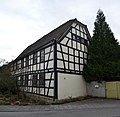

Pretty half-timbered houses in the old town

War Memorial First World War

Old paper mill


Economy and Infrastructure
Economic structure
Until the 19th century Okriftel was dominated by agriculture. The establishment of a pulp and paper factory, later the Phrix cellulose factory, in 1884 was of decisive importance for the industrial development of Okriftel . From 1885 (or 1886) it was run by the Jewish entrepreneur Philipp Offenheimer († 1930), whose family emigrated after the National Socialists came to power and were expropriated in 1938 as part of the Aryanization . After the Second World War , the factory was transferred back to the Offenheimer family, but a short time later it was sold to Phrix-Werke AG . In 1961, the Phrix employed around 1,000 people in Okriftel, but was then shut down in 1970, among other things because compliance with environmental regulations would have required excessive investments. However, the Phrix was not demolished, but remained a largely unused industrial ruin.
Larger local industrial companies are today the Hilscher Gesellschaft für Systemautomation mbH or the Hessische Bewehrungsstahl GmbH .
Many residents are commuters. The most important employers include Frankfurt Airport , Opel in Rüsselsheim or the successor companies of the former Hoechst AG in the Höchst industrial park .
traffic

Okriftel is on the L 6006 state road, which runs from Eddersheim in the southwest to Frankfurt-Sindlingen in the northeast. At the level of the town center, Landesstraße L 3011 branches off from this street as Mainstraße to the north in the direction of the core town of Hattersheim.
In Okriftel there has been the Main ferry Okriftel over the Main since 1716 , which leads to Kelsterbach . From Walldorf , the district road K 152 leads as Okrifteler Straße exactly to the ferry ramp on the Okriftel opposite bank of the Main. However, due to the expansion of Frankfurt am Main Airport and the West Runway , this road had to be considerably rebuilt and re-routed.
Several cycle paths run along the banks of the Main :
- The Hessian long -distance cycle route R3 ( Rhein-Main-Kinzig-Radweg ) leads under the motto In the footsteps of the late rider . along the Rhine , Main and Kinzig via Fulda to Tann in the Rhön .
- The Main Cycle Path leads from the sources of the White and Red Main to Mainz where it flows into the Rhine .
- The D-Route 5 (Saar-Mosel-Main) from Saarbrücken via Trier, Koblenz, Mainz, Frankfurt am Main, Würzburg and Bayreuth to the Czech border (1,021 km).
Web links
- History of Okriftel on the website of the city of Hattersheim am Main.
- Okriftel, Main-Taunus-Kreis. Historical local dictionary for Hessen. In: Landesgeschichtliches Informationssystem Hessen (LAGIS).
- Literature on Okriftel in the Hessian Bibliography
Individual evidence
- ↑ a b c Okriftel, Main-Taunus-Kreis. Historical local dictionary for Hessen. (As of February 9, 2018). In: Landesgeschichtliches Informationssystem Hessen (LAGIS).
- ^ Hattersheim am Main: Population figures ( Memento from September 15, 2016 in the Internet Archive )
- ^ Municipal reform in Hesse: mergers and integrations of municipalities from June 21, 1972 . In: The Hessian Minister of the Interior (ed.): State Gazette for the State of Hesse. 1972 No. 28 , p. 1197 , point 851 para. 1. ( Online at the information system of the Hessian State Parliament [PDF; 4.4 MB ]).
- ^ Federal Statistical Office (ed.): Historical municipality directory for the Federal Republic of Germany. Name, border and key number changes in municipalities, counties and administrative districts from May 27, 1970 to December 31, 1982 . W. Kohlhammer GmbH, Stuttgart and Mainz 1983, ISBN 3-17-003263-1 , p. 370 and 372 .
- ^ Presentation of the Church of St. Martinus Christ-König in Okriftel
- ^ Society for Christian-Jewish Cooperation in the Main-Taunus-Kreis e. V. CJZ Main-Taunus , accessed on December 2, 2011
- ^ Cellulosefabrik Phrix ( Memento from February 11, 2012 in the Internet Archive ), accessed on December 1, 2011