
Hessian long-distance cycle route R3
| Hessian long-distance cycle route R3 | |
|---|---|
|
|
|
| overall length | 258 km |
| location | Hesse / Rheingau Rhine-Main area , Rhön |
| map | |
| Link to map and elevation profile | |
| Starting point | Rudesheim am Rhein |
| Target point | Tann (Rhön) |
| Places along the way | Rüdesheim am Rhein ( Bf ), Geisenheim ( Bf ), Eltville am Rhein ( Bf ), Wiesbaden ( Bf ), Hochheim ( Bf ), Flörsheim ( Bf ), Frankfurt ( Bf ), Offenbach ( Bf ), Hanau ( Bf ), Langenselbold ( Bf ), Gelnhausen ( Bf ), Wächtersbach ( Bf ), Bad Soden-Salmünster ( Bf ), Steinau an der Straße ( Bf ), Schlüchtern ( Bf ), Flieden ( Bf ), Neuhof ( Bf ), Fulda ( Bf ), Hofbieber , Tann |
| Flooring | approx. 83% asphalt or concrete, approx. 7% water-bound surface , the rest natural paths |
| difficulty | Flat to Schlüchtern. After that, seldom more than 3% incline. |
| Traffic volume | Low, in the cities partly over streets |
| Connection to | Rhein-Radweg , Main-Radweg , Vogelsberger Südbahnradweg , Hessischer Radfernweg R1 , Hessischer Radfernweg R2 , D-Route 9, Rhönradweg , Ulstertalradweg , further see section Connecting Cycle Paths |
| ADFC certification |
Description at ADFC ADFC classifications |
| Website URL | radroutenplaner.hessen |
The Hessian long-distance cycle route R3 is one of nine long-distance cycle routes in Hessen . It bears the name Rhein-Main-Kinzig-Radweg and has the motto In the footsteps of the late harvest rider . The long- distance cycle path begins in Rüdesheim am Rhein and runs mainly on paved paths along the Rhine , Main and Kinzig via Fulda to Tann in the Rhön. The total length is 258 kilometers.
Characteristic
The R3 cycle path leads through the Rheingau-Taunus , Main-Taunus , Offenbach , Main-Kinzig and Fulda districts . Between Fulda and Hilders , the R3 is identical to the Milseburgradweg . On this section the bike path leads through the Milseburg tunnel . This is officially closed from November to March to protect bats . In practice, the closure depends on the bats' need for rest and can last until mid-April. For example, in 2009 the tunnel was not reopened until April 19. The route along the Rhine, Main and Kinzig is flat; Significant gradients can only be expected after Schlüchtern. The ascent into the Rhön is made much easier by the route along the former route of the Rhön Railway. Slopes of more than 3% are rare. The ADFC only qualifies about 50% of the route as suitable for road cycling. The traffic load is low, as the route is almost exclusively led by bike paths. In Hanau and Fulda, however, roads are sometimes used. The route leads almost exclusively through open terrain with a few shady sections.
Route description
The entire route was divided into sections of around 50 kilometers. In the case of possible alternative routes, shorter stages may have been chosen. The information on distances and elevation profiles were taken from the Hesse cycle route planner.
Rudesheim - Eltville

Rudesheim with the Boosenburg tower

Rheingau Cathedral

Johannisberg Castle
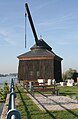
Oestrich crane

Eberbach Monastery

Electoral castle


Two variants are possible on this section: the more demanding route via the Eberbach Monastery or the flat route on the banks of the Rhine.
Rüdesheim - Eltville (R3a via Eberbach Monastery)
Length 22.5 km; Gradients 288 meters in altitude.
This route largely follows the Rheingau-Riesling-Route via Geisenheim , Johannesberg, Oestrich-Winkel and Hallgarten to the Eberbach Monastery . This alternative is signposted as R3a, on older maps as R3. The former Cistercian monastery, with its Romanesque and early Gothic buildings, is one of the most important art monuments in Germany. Johannisberg is probably the most famous district of Geisenheim, as it is the birthplace of the late harvest (more precisely: the systematic production of Auslese ) and world-famous for its vineyards. In Schloss Johannisberg a statue to the unknown Spätlesereiter recalls. The distance between Rüdesheim and Johannesberg is approx. 5.5 km. From here to the wine village of Oestrich-Winkel it is two kilometers. Vollrads Castle is located above the village . It claims to be the oldest winery in Germany. The next wine village Hallgarten is approx. 5 km. On the route between Hallgarten and Eberbach Monastery, about 80 meters in altitude must be mastered over a distance of approx. 2.5 km.
After another 7 km descent , Eltville, which is 150 meters lower, is reached via Kiedrich .
Rüdesheim - Eltville (banks of the Rhine)
Length 16.5 km; Inclines 39 meters in altitude.
The newly paved main path leads along the Rhine cycle path along the banks of the Rhine and touches the Rheingau wine towns of Geisenheim , Oestrich-Winkel , Hattenheim and Erbach before reaching Eltville . Between Geisenheim and the Winkel district, the riverside path was closed and instead the cycle and pedestrian path was rebuilt close to the noisy main road, because the zone to the bank was declared a nature reserve as a compensation area due to the expansion of Frankfurt Airport.
The sights of Brömserburg and Adlerturm in Rüdesheim, the Rheingau Cathedral and Schönborn Palace in Geisenheim, and in Oestrich-Winkel the city's landmark, the Oestricher Kran , the Graue Haus and the St. Aegidius basilica are close to the cycle path . In Eltville, the Sebastiansturm as the cornerstone of the city fortifications and the Electoral Castle and Castle Crass follow .
Eltville - Frankfurt

Biebrich Castle from the park side

St. Peter and Paul surrounded by vines
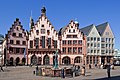
Römerberg in Frankfurt

Frankfurt skyline


Length 52 km; Gradients 144 meters in altitude.
After Eltville, route R3 follows the Rhine cycle path and after approx. 3 km reaches the wine town of Walluf . The route then crosses the former water catchment area of the Schierstein waterworks, where a large number of storks have settled, before reaching the Schierstein harbor after 3.5 km . Today the harbor is a recreational area for Wiesbaden and the surrounding area and houses a water sports center. After another 2.8 km, the route reaches Wiesbaden-Biebrich with its castle , in whose spacious park the famous Wiesbaden International Whitsun tournament is held every year . The three-wing baroque building, built directly on the banks of the Rhine, was the residence of the princes and dukes of the Nassau family . Parts of the palace are now used as representative rooms for the Hessian Prime Minister. The R3 continues to follow the Rhine Cycle Route, before changing to the Main Cycle Route after about 7 km across from the Mainspitze . After 4.5 km, the route reaches Hochheim train station , which still belongs to the Rheingau wine-growing region . It is 0.8 km and 30 meters in altitude to the Hochheimer church Sankt Peter und Paul, which can be seen from afar . Only after 7 km between the Main and vineyards and later through industrial areas does the route reach the banks of the Main in the city of Flörsheim . The path then runs along the banks of the Main or on the flood dam , crosses under the A3 motorway and after 9 km reaches the Eddersheim lock . The R3 route is signposted here on both the southern and northern banks of the Main, until the two alternatives come together again at Industriepark Höchst . The south bank variant crosses the Main with the barrage and runs in the bank area past Kelsterbach , before it joins the north bank variant after 7 km and passing under the B40 . The north bank variant has a length of 7.6 km, leads through the town of Okriftel , crosses under the B40 and crosses the Main with the help of the west bridge , before it reunites with the south bank variant. After about 4 km past the industrial park, the route leads back to the banks of the Main, where shortly afterwards the Frankfurt district of Schwanheim is reached. Besides Sachsenhausen, it is known for its apple wine bars . The Griesheim barrage and the Frankfurt-Niederrad district are then passed along the banks of the Main , before the Museum Bank in Frankfurt is reached after approx. 7 km . This collection of 15 museums on both banks of the Main or in the immediate vicinity form one of the most important museum locations in Germany and Europe. On the southern shore, the area is Sachsenhausen , which over the footbridge Iron Bridge with Frankfurt's Old Town is connected. The center of the old town is the Römerberg with the Römer as the town hall. From the bike path you can see the famous skyline on the north bank of the Main. This skyline has earned the city the nickname Mainhattan .
Frankfurt - Gelnhausen

Büsing Palais

Old Town Hall, Hanau

Obermarkt, Gelnhausen
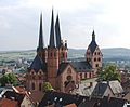
Marienkirche Gelnhausen


Length 52 km; Gradients 143 meters in altitude.
The R3 route runs along the south bank of the Main, past the monument to the artist Hans Traxler and the Gerbermühle , where Johann Wolfgang von Goethe used to travel, before the cycle path reaches Offenbach harbor after approx. 7 km. After leaving the port area, which has been being converted into a residential area since 2012, the path reaches the well-tended Offenbacher Mainufer. In the immediate vicinity of the route is the Büsing Park with the neo-baroque Büsing Palais and the Lili Temple . Behind the Offenbacher Mainbogen, the urban landscape merges into the natural landscape of the banks of the Main, and the route reaches approx. 7 km after the port of Rumpenheim with its castle built under the rule of the County of Hanau in the 16th century . The cycle path changes the banks of the Main by ferry, leads past Dörnigheim , a district of Maintal , to Philippsruhe Castle in Hanau-Kesselstadt , about 7 km away and directly on the Main . The historicist style complex with an English landscape garden was brought into its current form at the end of the 19th century. At the mouth of the Kinzig , the cycle path leaves the Main and runs through Hanau near the river. The path leads only a few meters past the Hanauer Goldschmiedehaus , the former town hall on the old town market . Then he follows the Kinzig before he leaves it together with the expressway heading south into a forest area, the natural Bulau . The route crosses the A 66 and continues on the street (now Leipziger Straße) to the outskirts of Erlensee , which is approx. 17 km behind Philippsruhe Castle. The R3 runs through the wide Kinzig valley, mostly between the river and the A 66 motorway . Forests, fields and meadows alternate. In Langenselbold you have the option of either following the route through the city or, following alternative signs, driving around the city to the south. After approx. 22 km the Kaiserpfalz in Gelnhausen and thus the stage destination is reached. It is worth paying a visit to the Barbarossa city with the lower and upper market, which is well worth seeing, as well as the Marienkirche with its eventful architectural history.
Gelnhausen - Fulda
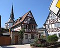
Bad Soden Huttenschloss

Kinzigstalsperre in autumn

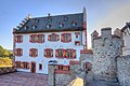
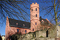
Steinau Castle

Cathedral of St. Salvator in Fulda

Bieberstein Castle from Langenbieber

Milseburg

View into the illuminated Milseburg tunnel
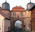
City gate in Tann


Length 67 km; Gradients 565 meters in altitude.
The R3 runs north of the A 66 through the Kinzig valley and follows the railway line between Gelnhausen and Wächtersbach through open terrain, which is reached after approx. 11 km. The route leads past Gelnhausen-Höchst and Biebergemünd-Wirtheim with its Renaissance castle from the 15th century. After a further 7 km through meadows and fields, the Salmünster district of the city of Bad Soden-Salmünster is reached. About 0.7 km off the bike path there is a former Franciscan monastery with the monastery church of St. Peter and Paul as well as the aristocratic seat Schleifrashof from the 16th century. The cycle route runs along the edge of the forest to the north, past Salmünster and after 1.6 km it reaches the Bad Soden district . This is where the city's spa area is located with the Spessart thermal baths, spa gardens and graduation tower. The Stolzenberg castle ruins and the Huttenschloss , the most important historical building in Bad Soden, are also located in the district. The route leaves Bad Soden, reaches the open area of the Kinzig valley and crosses the A 66 again before reaching the Kinzig dam after 3.8 km . The R3 runs along the northern bank of the reservoir and after 5.6 km reaches the Brothers Grimm House in Steinau an der Strasse , which is officially allowed to be called Brothers Grimm City. Steinau Castle is also worth seeing . It is the earliest, largest and best-preserved early Renaissance palace complex in Hesse. After leaving the city, the path continues through the meadows and fields of the Kinzig Valley and after approx. 8 km reaches the center of Schlüchtern. The route through Schlüchtern leads past the former Benedictine monastery and the Bergwinkel Museum, where the past of Schlüchtern is kept alive with modern means of communication. In Schlüchtern the route leaves the Kinzig valley and follows the Riedbach northwards, alternating between forest, meadows and fields. The flat part of the R3 ends with Schlüchtern, and it is the first incline to be mastered, which is around 140 meters in altitude over four kilometers. Then the A 66 is crossed again, this time in a northbound direction, and after about 10 km the route reaches the municipality of Flieden over sloping, hilly terrain . Then it continues hilly through open terrain to the Neuhof train station approx. 5 km away . The R3 is now based on the railway line to Fulda and leads through open terrain and at times along the edge of the forest, slightly hilly and with a downward tendency towards Fulda. First you reach the Johannesberg district and shortly afterwards after a total of 15 km the city center. The baroque and episcopal city of Fulda offers a whole range of sights, including the cathedral , the city palace with park and orangery, the Paulustor as well as the baroque quarter and many churches. The tourist office offers an audio guide for an hour-long tour .
Fulda - Tann
Length 43.5 km; Inclines 523 meters in altitude.
Together with the Hesse railway cycle route, the route leaves the city of Fulda in a stream valley and crosses the A7 after 5 km . A gradient of 55 meters in altitude has to be overcome over a length of one kilometer. The Milseburgradweg begins there in Götzenhof , on which the route follows the former route of the Rhönbahn . The former stops on the railway line are now equipped with shelters. The route is flat at first and then with a slight incline (approx. 2%) and after 17 km it reaches the Milseburg tunnel . The path through meadows and fields follows the course of the Bieber and passes the towns of Almendorf , Melzdorf , Wiesen , Niederbieber and Langenbieber . The baroque castle Bieberstein and the Milseburg on the highest elevation of the southern Rhön can be seen from the bike path. After Niederbieber, the path continues to gain altitude in a long S-loop through a forest area before it reaches the tunnel entrance. The illuminated tunnel is 1173 m long and is only open from April 1st to October 31st. Therefore, there is a bypass route, on which, however, 150 meters in altitude must be overcome over a distance of around 4 km. The tunnel ends in front of the village of Oberbernhards at the former Milseburg station. The R3 together with the Milseburgradweg and the Hesse railway cycle path run for 7 km, descending around 150 meters in altitude, through an open brook valley through the towns of Rupsroth and Eckweisbach to the hamlet of Aura, which belongs to the town of Tann . Here the Milseburgradweg turns south towards Hilders, where it ends after 2 km. Instead, the Rhönradweg and the Ulstertalradweg join the R3. The cycle routes lead through the Ulstertal with open meadows and fields to the north. The path leads over sloping terrain and after approx. 9 km reaches the town of Tann, which is 43 meters lower, with its renovated town gate and Tann Castle . The R3 then continues along with the cycle paths Bahnradweg Hessen, Ulstertalradweg and Rhönradweg about 5 km to the Hessian border. The other cycle paths continue to follow Ulster towards Geisa in Thuringia .
Connecting cycle paths
- The R3 runs along the Rhine Cycle Route between Oestrich-Winkel and Mainz-Kostheim .
- The variant via the Eberbach monastery and on the Eltville - Hochheim am Main section, the R3 runs largely together with the Rheingau Riesling route .
- On the Mainz-Kostheim - Offenbach-Rumpenheim section, the R3, the Main Cycle Route and the D-Route 5 ( Saar-Mosel-Main ) largely run together. The Hessian long-distance cycle route R6 also crosses in Mainz-Kostheim . This leads over 404 km from Waldecker Land into the Rhine Valley.
- The Hessian long-distance cycle route R8 crosses in Frankfurt-Höchst . It leads over 297 km from the Edertal through the Westerwald and Taunus to the Bergstrasse.
- The Hessen railway cycle path and the R3 use the same route from Philippsruhe Castle in Hanau to Wächtersbach and from Fulda to Tann.
- In Erlensee in Main-Kinzig-Kreis crosses German Limes cycle path to R3.
- In Maintal crosses Hessian cycle path R4 to R3. This leads from Bad Karlshafen on the Weser over 415 km to Hirschhorn am Neckar.
- In Wächtersbach, the Vogelsberger Südbahnradweg meets the R3. This creates a 35 km long connection between the volcano cycle path in Vogelsberg and the Kinzig valley.
- A number of cycle paths meet in Fulda:
- The Hessian Radfernweg R1 (Fulda-Radweg) leads over 250 km from the heights of the Rhön along the Fulda to Bad Karlshafen on the Weser .
- The Hessian long-distance cycle route R2 (The Four Rivers Tour) starts in Biedenkopf and leads over 202 km through the river valleys from Lahn , Lauter , Lüder and Fulda to Sinntal in Spessart .
- The D-Route 9 Weser-Romantic Road leads from the North Sea via Bremen, Kassel, Fulda and the Taubertal to Füssen in Allgäu (1,197 km).
- The regional themed route Milseburgradweg is part of the R3 between Fulda and Hilders.
- Between Tann and the Hessian / Thuringian border, the R3, Rhönradweg and Ulstertalradweg run on the same route and guarantee the connection to the Thuringian area of the Rhön.
Train and bus connections
There are rail connections on the entire route between Rüdesheim and Fulda (see also info box ). The Rheingau line runs every hour between Rüdesheim station and Frankfurt main station . It stops at all stations on this route marked in the info box. S-Bahn lines S8 and S9 as well as regional trains with stops in Offenbach run between Frankfurt and Hanau. The RE 50 regional line runs every hour between Frankfurt Central Station and Fulda. It thus covers the Offenbach and Fulda area with all of the locations mentioned in the info box. Behind Fulda there is no longer any connection to an active railway line. From May 1st to October 3rd, you can use the RhönRadbus on Saturdays, Sundays and public holidays. It runs every two hours between Fulda and Gersfeld and has stops in Langenbieber and Hilders. After Hilders there are no more stops.
Landscape, culture and sights
The route leads from the vineyards of the Rheingau along the Rhine and Main to the mouth of the Kinzig. The route owes the nickname Spätlesereiter to the fact that the Johannisberg Castle was owned by the Diocese of Fulda and from there the order for the start of the grape harvest had to come. Since the messenger on horseback was late, the grapes stayed longer on the vines than usual and were attacked by gray mold rot. Although the grapes were thought to have been spoiled, they were pressed and, when tasted the following year, the wine surprised with its exceptional quality. The term late harvest then became common for particularly high-quality wines, and the positive effects of noble rot , the infestation by the mold Botrytis cinerea , were discovered. The Rheingau extends to Hochheim am Main, where the British Queen Victoria also got her wine from. The Queen Victoria Monument in the middle of the vineyards is still a reminder today. On the way there, many well-known wine towns such as Oestrich-Winkel and Eltville are crossed, and on the alternative route through the vineyards, the famous Eberbach Monastery is passed. The route then leads along the Main through the metropolitan area of the Rhine-Main area . This is particularly evident on the Museumsufer in Frankfurt, where the city skyline appears. The confluence of the Kinzig and the Main is reached near Hanau through urban, natural and industrial landscapes. In the wide Kinzig valley, nature again predominates with extensive meadows. However, the nearby motorway still gives an idea of the nearby urban region. In the Barbarossa town of Gelnhausen, the imperial palace, the two marketplaces and the lovely St. Mary's Church can be visited. Still close to the A 66 motorway , the cycle path leads through the upper Kinzig valley, past Wächtersbach, the spa town of Bad Soden-Salmünster and the Kinzig dam to Schlüchtern. Through the foothills of the southern Vogelsberg, the cycle path gains height and leads through rural areas, mostly through open fields and meadows to the city of Fulda. The baroque and episcopal city of Fulda is certainly a cultural highlight on the R3. Of the many churches, the St. Salvator Cathedral in Fulda is certainly the best known. The city palace and many baroque buildings can also be visited. After leaving Fulda, the R3 crosses the rural area of the Rhön and climbs its heights via the Milseburgradweg on a disused railway line. After Hilders the Ulstertal is reached, which the path follows. After Tann, the R3 ends at the Hessian-Thuringian border. The continuation towards Geisa in the Thuringian part of the Rhön is taken over by the Rhön Cycle Path and the Ulstertal Cycle Path .
Sights between Rüdesheim and Frankfurt

Niederwald Monument

Ehrenfels castle ruins

Rudesheim Drosselgasse

Basilica of Johannisberg Castle

Schönborn Castle in Geisenheim

Palais Ostein in Geisenheim

Vollrads Castle in the vineyards
Crass Castle in Eltville
The village of Eltville-Erbach

Basilica of the Eberbach Monastery


- The wine town of Rüdesheim am Rhein belongs to the UNESCO World Heritage Upper Middle Rhine Valley . It lies at the foot of the Niederwald forest with the Niederwald monument and is one of the most famous tourist attractions in Germany. The best-known is probably Drosselgasse , around which restaurants and hotels are concentrated in the old town. In addition, Rüdesheim offers a number of other attractions, such as
- The Osteinschen Landschaftspark Niederwald from the 18th century
- The parish church of St. Jakob from the 15th century
- The ruins of Ehrenfels Castle on the northeast bank of the Rhine on the steep slope of the Rüdesheimer Berg , which includes several of the best vineyards in Germany.
- The Brömserburg (also Niederburg ) is the oldest castle in the Upper Middle Rhine Valley World Heritage and houses the Rheingau Wine Museum.
- The Boosenburg (also Oberburg ) with the 38 m high, preserved tower.
- The Klunkhardshof is a large half-timbered house from the 15th century
- The noble houses in Oberstraße: Brömserhof , Groenesteynscher Hof and Bassenheimer Hof
- Adlerturm from the 15th century - the 20.5 m high late Gothic corner tower of the old city fortifications used to be located directly on the Rhine.
- The Binger Mouse Tower from the 14th century on the Rhine Island
- The St. Hildegard Benedictine Abbey above the Eibingen district
- The parish church of St. Hildegard emerged from the remains of the Benedictine monastery founded by Hildegard von Bingen in 1165
- The Geisenheim research institute for viticulture and horticulture has been located in Geisenheim since 1872. The research institute cooperates in the field of education with the RheinMain University of Applied Sciences , which operates a department in Geisenheim. The main focus of the research institute is horticulture and viticulture. In the city are among other things worth seeing:
- The Rheingau Cathedral with its neo-Gothic double tower facade from the 19th century and the nave and choir from the beginning of the 16th century
- The old factory hall is an important industrial monument of the long-standing mechanical engineering tradition in Geisenheim.
- Schönborn Castle (former Stockheimer Hof), built in 1550, stands at the train station in the middle of a vineyard
- The Palais Ostein was a summer residence of the last Count von Ostein . The horseshoe-shaped complex dates from the 18th century, around 1811 the splendid central building was closed due to the separation of property. Today the palace is owned by the St. Ursula School
- The wine town of Oestrich-Winkel has a wine loading crane from the 18th century as a landmark on the banks of the Rhine . Reichartshausen Palace (founded in the 12th century) is located on the north-eastern border of the municipality near Hattenheim , with its farm buildings disguised as artificial ruins around 1900 . Today it houses the European Business School . Other attractions are
- The St. Aegidius Basilica in the Mittelheim district from the early 12th century, one of the oldest stone churches in Germany
- In Winkel stands one of the oldest preserved stone houses in Germany, the Gray House from the late 10th century.
- Vollrads Castle is located above the village . The core of today's castle is a massive
- The electoral castle from the 14th century is located directly on the Rhine
- Half-timbered houses from the 16th and 18th centuries
- Reinhartshausen Castle , located near the Rhine, was the ancestral seat of the Knights of Erbach
- The parish church of St. Peter and Paul from the 14th century
- The parish church of St. Markus from the 15th century and the Evangelical church in Erbach from the 19th century
- The parish church of St. Vincentius in the district of Hattenheim
- The Burg Crass also called Rheinsberg Castle, just outside the old city walls on the Rhine towards Walluf . The castle, which was built around 1000 to 1100, is considered the oldest preserved building in the city
- The Cistercian - Kloster Eberbach is also one of Eltville. With its Romanesque and early Gothic buildings, it is one of the most important art monuments in Germany. Almost all of the interior shots for the film The Name of the Rose were shot in the monastery in the winter of 1985/86
Sights between Frankfurt and Tann

Lili Temple in Offenbach

Rosenheim Museum Offenbach

Rumpenheim Castle

Marienkirche Hanau

Brothers Grimm monument in Hanau

Garden facade of Philippsruhe Palace

Kaiserpfalz Gelnhausen

Hexenturm in Gelnhausen

The castle tower over Steinau

Noble palace in the baroque district of Fulda

Old town hall in Fulda
Paulustor in Fulda


-
Offenbach am Main is known for the headquarters of the German Weather Service, and it used to be for its leather goods industry. The German Leather Museum still bears witness to this today . The Büsing-Park with the neo-baroque Büsing-Palais and the Lili-Tempel is located near the R3 . Rumpenheim Castle is located directly on the R3 in the Offenbach-Rumpenheim district . Other museums in Offenbach are:
- The Klingspor Museum offers international book and script art. The basis of the museum is the collection of Karl Klingspor and the Offenbacher
- The Haus der Stadtgeschichte , which emerged from the city museum and the city archive, shows the historical development of the city of Offenbach. The focus is on the Offenbach factories , the Huguenots and the printing industry
- In the old town the German goldsmith's house (formerly the old town hall), the Marienkirche , outbuildings of the otherwise destroyed town palace Hanau and the castle garden Hanau in the old town;
- In Neustadt the Walloon-Dutch Church , the place where the German Gymnastics Federation was founded, and the Brothers Grimm National Monument right in front of the Neustadt town hall
- In the outskirts: Philippsruhe Castle on the banks of the Main with the Hanau Historical Museum and a paper theater museum as well as the historic Wilhelmsbad spa complex
- The Kaiserpfalz (also called "Barbarossaburg") was built on a Kinziginsel, southeast of Gelnhausen, immediately after the city was founded. It was one of the smaller palatinate buildings by Friedrich I.
- The Hexenturm is an originally preserved turret from the middle of the 15th century. In the first time of its existence it was called Fratzenstein . It got its current name from the fact that alleged witches were imprisoned there during the witch hunts
- The Marienkirche in Gelnhausen is the former church of the Premonstratensian monastery Langenselbold. It probably dates from the late 12th century and was first documented in 1223 in a letter of protection from Pope Honorius III. for the monastery Selbold mentioned
- The keep of the Stolzenberg castle ruins (first mentioned in 1252) high above the city has been accessible as a viewing tower since 1970, from which one overlooks the city of Bad Soden, the Kinzig valley and the outskirts of Hohem Vogelsberg and Spessart
- The most important historical building in the valley is the Huttenschloss , a late medieval building with bay windows, a high stepped gable and a stair tower. It was built in 1536 by Lukas von Hutten and his wife Apollonia von Frankenstein
- The former town hall of Bad Soden, built in 1703 (now the registry office) with hipped roof and onion dome (added in 1866) is the only baroque half-timbered town hall in Hesse
- The Steinau Castle , a secondary residence of the lords and counts of Hanau . It is the earliest, largest and best-preserved early Renaissance palace complex in Hesse
- The office building (built in 1562), the former regional administrative seat, today the Brothers Grimm House in Steinau
- The Amtshofscheune (built around 1562), former barn of the Amtshof, today the Steinau Museum
- The Vonderau Museum is named after the local researcher Prof. Joseph Vonderau . There are numerous finds from prehistoric times, as well as pieces from the Celtic settlement of the Fulda area . A planetarium is part of the museum
- The German Fire Brigade Museum in Fulda-Neuenberg shows the history of German fire extinguishing on 1,600 m² of exhibition space
- The Fulda Children's Academy with its "walk-in heart" is the first independent children's museum in Germany.
- In addition to the St. Salvator Cathedral, there are many other churches. For example the parish church of St. Blaise , the Holy Spirit Church and the Severikirche . Right next to or above the cathedral is one of the oldest churches in Germany, the Michaelskirche
- The city palace with park and orangery
- Baroque buildings are the Paulustor , the old town hall, the old university and the noble palace.
literature
- Rhein-Main-Kinzig cycle path: on the trail of the late rider. VUD Verlag und Druck, Freudenstadt 2005, ISBN 3-923719-75-2 .
Web links
- Hess. R3 long-distance cycle path at www.hessen-tourismus.de
- Bicycle Routes & Tours: Hess. Long-distance cycle route R3: Rhine - Main - Kinzig , with map, GPS download, altitude profile, sights and accommodations
- Route descriptions at achim-bartoschek.de
- Relation to OpenStreetMap
swell
- Wikipedia pages and websites of the villages along the route. Accessed June 2012.
Individual evidence
- ↑ 2009 cycling map of the Hessian Ministry of Economics, Transport and Rural Development, Press and Public Relations Department, Wiesbaden
- ↑ Radroutenplaner.hessen.de . Accessed June 2012.
Coordinates: 49 ° 58 ′ 44 ″ N , 7 ° 56 ′ 31 ″ E