
Fulda (river)
|
Fulda Gersfelder Wasser (upper course) |
||
 The catchment area of the Fulda (highlighted) |
||
| Data | ||
| Water code | EN : 42 | |
| location | Hessen , Lower Saxony ( Germany ) | |
| River system | Weser | |
| Drain over | Weser → North Sea | |
| source | on the Wasserkuppe (southeastern Fulda spring) 50 ° 29 ′ 31 ″ N , 9 ° 57 ′ 12 ″ E |
|
| Source height | 850 m above sea level NHN | |
| confluence | in Hann. Münden with the Werra to the Weser Coordinates: 51 ° 25 '16 " N , 9 ° 38' 53" E 51 ° 25 '16 " N , 9 ° 38' 53" E |
|
| Mouth height | 116.5 m above sea level NHN | |
| Height difference | 733.5 m | |
| Bottom slope | 3.3 ‰ | |
| length | 220.4 km | |
| Catchment area | 6,946.592 km² | |
| Discharge at the Hettenhausen A Eo gauge : 55.5 km² Location: 202 km above the mouth |
NNQ (08/25/1976) MNQ 1972/2012 MQ 1972/2012 Mq 1972/2012 MHQ 1972/2012 HHQ (09/28/2007) |
80 l / s 172 l / s 930 l / s 16.8 l / (s km²) 14.1 m³ / s 30.4 m³ / s |
| Discharge at the Grebenau A Eo gauge : 2975 km² Location: 55.5 km above the mouth |
NNQ (07/08/1952) MNQ 1951/2014 MQ 1951/2014 Mq 1951/2014 MHQ 1951/2014 HHQ (01/24/1995) |
2.5 m³ / s 7.42 m³ / s 26.1 m³ / s 8.8 l / (s km²) 223 m³ / s 690 m³ / s |
| Discharge at the Guntershausen A Eo gauge: 6366 km² Location: 44 km above the mouth |
NNQ (09/16/1959) MNQ 1941/2014 MQ 1941/2014 Mq 1941/2014 MHQ 1941/2014 HHQ (05/17/1943) |
7.36 m³ / s 17 m³ / s 57.3 m³ / s 9 l / (s km²) 394 m³ / s 2800 m³ / s |
| Discharge (extrapolated) A Eo : 6,946.6 km² at the mouth |
MNQ 1961/1990 MQ 1961/1990 Mq 1961/1990 |
18.739 m³ / s 66.924 m³ / s 9.6 l / (s km²) |
| Left tributaries | Fliede , Lüder , Schlitz , Jossa , Aula , Eder | |
| Right tributaries | Haune , Pfieffe , Losse | |
| Big cities | kassel | |
| Medium-sized cities | Bad Hersfeld , Fulda , Hann. Münden | |
| Small towns | Gersfeld , Schlitz , Bebra , Rotenburg an der Fulda , Melsungen | |
| Navigable | 109 km; Federal waterway from km 0.0 at Mecklar, non-stop passenger and sport shipping from Kassel | |
| Location northwest of Fulda spring : 50 ° 29 ′ 40 ″ N , 9 ° 56 ′ 42 ″ E |
||
 The Fulda near Bad Hersfeld |
||
The Fulda , also called Gersfelder Wasser in the upper reaches , is the 220.4 km long left source river of the Weser . It rises in the Hessian part of the Rhön at the Wasserkuppe and ends between the Kaufunger Wald and Reinhardswald in the three-river city of Hann. Münden (Lower Saxony), where it unites with the Werra coming from the right to the Weser.
The 6,947 km² drainage area of the Fulda is the shorter of the two Weser source rivers, but at the confluence it carries a little more water. Of this, in turn, about half of the Eder comes from , which it only flows into in the lower reaches.
Within Hesse, the Fulda is the river with the longest flow length.
River course
swell
The two sources of the Fulda, which are on the southern slope of the Wasserkuppe ( 950.2 m ) at around 850 m above sea level. NHN are located between Poppenhausen - Abtsroda and Gersfeld - Obernhausen .
The geographic coordinates of the Fulda springs are:
- The southeastern Fulda spring ( ⊙ ) is about 1,400 m southeast of the mountain peak; the river kilometrage refers to this contained source .
- The northwestern Fulda spring ( ⊙ ) is about 700 m southeast of the mountain summit.
The Fulda springs can be reached via the state road 3068, which crosses the federal highway 458 at Hilders -Dietges and, as part of the Hochrhönring , leads south via Abtsroda past the Fulda springs to Obernhausen to the B 284 .
The eastern, beautifully framed spring shown in the picture is not the real Fulda spring. This is much higher, almost below the summit. When construction began over 80 years ago, they were enclosed and used to supply the buildings with drinking water. The overflow was led by a pipeline to the point that is now given as the Fulda spring.
The following poem is written on the blackboard at the Wasserkuppe:
Stop here! You are refreshed by the source of
the Fulda, which
rushes along with the mountain salute with a clear wave ,
it grows towards the Werra,
to the German river and sinks the waves
into the sea as the Weser is animated by ships.
- South-eastern Fulda spring
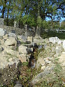
South-east of the Fulda spring 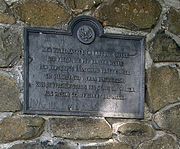
Inscription at this source 
17. Information board about the Fulda


Upper course
From the Wasserkuppe, the Fulda first flows in a southerly direction past the Feldberg to Gersfeld and has already overcome an altitude difference of 368 m after only 6 km of river length. From there it flows a few kilometers west to Eichenzell , where it bends north and then reaches the city of Fulda at an altitude of 275 m .
Middle course
On the left of the Fulda is the Vogelsberg and on the right the Kuppenrhön . A little further north it reaches the small town of Lüdermünd (district of Fulda), where the Lüder flows into it, then the town of Schlitz , where the Schlitz flows into it, then the village of Niederaula (district of Niederjossa), where the Jossa flows, and further north, Bad Hersfeld where the Haune , the Geisbach and the Solz flow to it.
After the Fulda has flowed through between the Knüllgebirge and Seulingswald , the Rohrbach flows from the left . The Fulda then reaches the village of Malsfeld via Bebra and Rotenburg ad Fulda , where the Beise flows into it. The Pfieffe flows into Obermelsungen and the Kehrenbach into Melsungen . The Mülmisch then flows slightly south of Körle .
The Fuldaknie is a bend in the river near the town of Bebra . Flowing in a north-easterly direction between the Knüllgebirge and the Seulingswald , the river makes a bend in a north-westerly direction in front of the Stölzinger Gebirge .
Lower course
After two loops in the river near Guxhagen , the Eder , the largest tributary that surpasses the Fulda in terms of water flow, flows into Grifte , a district of Edermünde , coming from the southwest , which is even 0.75 km longer than the Fulda in its previous course and the at the confluence in contrast to the Fulda does not change its direction. A little further north flow in Kassel , among others Drusel ( Small Fulda ), ancestor , Wahle , Losse and Nieste one.
Apart from a bend in the river, the Fulda flows from Kassel as a border river to southern Lower Saxony through an often narrow and very winding breakthrough valley , in which the aspen flows into it at Fuldatal - Simmershausen .
muzzle
Around 32 km below Kassel or further northeast, the water of the Fulda finally reaches Hann , located in southern Lower Saxony . Münden , where it joins the Werra to form the Weser at a height of 116.5 m .
Fulda in the narrow river valley near Wilhelmshausen

The Fulda in Kassel
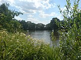
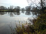
Scene below Kassel in July with meadowsweet and reed grass in the foreground
Wide Fulda below Kassel in November


Landscape image
Overview: The Fulda runs almost on its entire route in the Fulda valley, which has been washed out more or less deeply by it, in which it mainly fights through the red sandstone . This valley, on both sides of which there are mostly extensive forests and sometimes high mountains, actually only opens up in the extensive Kassel basin .
Upper course: In its mostly steeply sloping upper course, the valley width is sometimes only a few meters up to 250 m and later up to 500 m. At Eichenzell or Fulda , the valley widens a bit, only to then squeeze through the mountain slopes again.
Middle reaches: Around Bad Hersfeld and Bebra the valley is a maximum of 1.3 km wide and at Guxhagen again only a few hundred meters.
Lower reaches: Only at the confluence of the Eder , but above all near Kassel in the area of the Karls and Fuldaaue, the Fulda flows through a plain up to 3 km wide in its river lowland . After this big city she forces her way to Hann. Münden again through a narrow valley that is often only a few hundred meters wide.
Economic use
Shipping route
| Passenger shipping on the Fulda | |||||||||||||||||||||||||||||
|---|---|---|---|---|---|---|---|---|---|---|---|---|---|---|---|---|---|---|---|---|---|---|---|---|---|---|---|---|---|
|
|||||||||||||||||||||||||||||

Landgrave Moritz von Hessen had the Fulda made navigable to Hersfeld in 1601 and 1602 (there is still a lock from this time in Rotenburg). For this purpose, he had the “Fulda electricity map” made by Joist Moers in advance . Landgrave Moritz himself was the first to sail the river to Bebra in 1601, then down the Fulda to Rotenburg and on to Kassel. The plaque at Rotenburg Castle right next to the Rotenburg lock reminds of this memorable trip. At that time, the ships were mostly 20 to 24 m long and only 1.30 to 1.50 m wide. On the superstructure there was a front and a rear fort for overnight stays by the boatmen. The Fulda ships could load 250 to 350 hundredweight, were manned by two to three men and had sails and masts. Down the river it was mostly on its own. Where the current was not strong, for example in front of the passages or locks, the boatmen had to stake , that is, push the ship off the bottom with long iron- shod rods and push it forward. If the wind allowed it, the sail was used. If the ships got stuck on sandbanks and other shallows, the shiphands had to get into the water and push.
Things were more difficult upstream. Here the ships were pulled by a pair or two of horses on long lines. The teams went here on the bank on the towpath. It was mostly paved and, depending on the terrain, ran along the right or left bank. When changing sides, the horses quickly walked through the water. In winter they were transported to the other side of the ship. The teams for the landgrave's ships usually had to be provided by the neighboring villages.
The Thirty Years' War (1618-1648) almost completely destroyed the young Fulda shipping. Only Landgrave Carl von Hessen-Kassel then had the right to take shipping to new heights. There were reloading points (Schlagden) in Melsungen, Rotenburg and Hersfeld.
In 1805 there were still fifty boatman families living in Melsungen. In the Bad Hersfeld city cemetery, a tombstone of a boatman's family still reminds of this time. The Fulda shipping came to a standstill again from 1849 when the Bebra-Baunatal-Guntershausen railway was built.
The Fulda was regulated from 1890 by the construction of barrages; so between Bebra and Kassel 5 and between Kassel and Hann. Münden 8 barrages with needle weirs , the poor building structure and dangerous operation of which had to be renewed since the 1970s. A few barrages were completely demolished and others were restored or completely rebuilt, so that today there are only 5 barrages left in the Fulda lower reaches from Kassel: Kassel, Wahnhausen, Wilhelmshausen, Bonaforth and Hann. Münden. The highest of these is not far from Kassel - downstream - near Wahnhausen (built until 1980): It has a 8.48 m drop. The two-field roller weir in Kassel (1912) was restored from 1991 to 1993. This allows the Fulda from Kassel to Hann. Münden can be used as a shipping route: In the warm season, some motor ships (excursion traffic), rowing boats, paddle boats and sports boats operate there. The Kassel city lock from 1913 is to be restored.
The 32 km stretch of river from the confluence with the Werra to above Kassel is one of the unclassified federal waterways that serve general traffic, the remaining 77 km to Mecklar serve as other federal inland waterways . The waterways and shipping office in Hann is responsible for this . Münden . The Fulda begins at the weir in Mecklar at kilometer 0 and ends at the confluence with the Werra at 108.78 km.
At the beginning of the 20th century, the Fulda should become part of a gigantic canal system. The construction of a waterway from the North or Baltic Sea to the Black Sea (via Weser , Fulda, Kinzig , Main and Danube ) was planned. In some cases, up to 8 km long tunnels were planned to cross under the low mountain ranges. At Bergshausen (about 10 km southeast of Kassel) the construction of a dam has even started. At the end of the 1920s, all work and planning were stopped.
Locks
The locks of the Fulda (see also the shipping route section above ) are (viewed downstream):
| Name of the lock | Kilometers of waterways | Data | Construction year |
|---|---|---|---|
| Neumorschen lock | 26,589 | L 28 m / W 4.40 m / lifting or falling height 1.30 m | 1752 |
| Melsungen lock | 42,445 | L 24 m / W 4.40 m / lifting or falling height 1.10 m | 1752 |
| Guxhagen lock | 61.083 | L 24 m / W 4.40 m / lifting or falling height 1.20 m | 1752 |
| Lock Neue Mühle / Kassel | 75.770 | L 24 m / W 4.60 m / lifting or falling height 1.35 m | 1752 |
| City lock Kassel | 81.276 | L 85 m / W 10 m / lifting or falling height 2.84 m | 1913 |
| Wahnhausen lock | 93.48 | L 35 m / W 6.75 m / lifting or falling height 8.50 m | 1980 |
| Wilhelmshausen lock | 101.50 | L 35 m / W 7.50 m / lifting or falling height 2.44 m | 1988 |
| Bonaforth lock | 105.271 | L 35 m / W 7.50 m / lifting or falling height 2.41 m | 1990 |
| Fuldaschleuse Hannoversch Münden | 108.247 | L 58 m / W 8.60 m / lifting or falling height 2.86 m | 1897 |
Fulda power plants
Current hydropower plants on the Fulda include:
| place | Power [MW] |
operator | in operation since |
|---|---|---|---|
| Rotenburg ad Fulda, river power plant | 0.32 | Kraftwerk Haag GbR | 1943 |
| Kassel, Niederzwehren, Neue Mühle power station | 0.20 | Municipal Works Kassel | 1999 |
| Kassel, hydropower plant "Vogt'sche Mühle" | 0.60 | Lange-Spohr | 1958 |
| Fuldatal, Wahnhausen run-of-river power station | 4.00 | Statkraft | 1980 |
| Hann. Münden, hydroelectric power station | 0.22 | Wasserkraftwerk GmbH Kürschner | 1998 |

Water inlet of the Vogt'schen Mühle in Kassel

Wahnhausen barrage with power plant (left), weir system and lock (right)

Hydropower plant Kürschner in Hann. Münden


history
Origin of name
The origin of the name Fulda is still unclear. However, there are some assumptions about this (see Fulda, section Origin of names ).
Little Fulda
The Kleine Fulda , the lower reaches of the Drusel , still exists in the Kassel city area . The name comes from the historical development of the Karlsaue , when the Fulda flowed around it as part of an inland delta on both sides. The western arm of the river was called Kleine Fulda . With the further development and design of the park in the Middle Ages , this arm was partially filled in and the kitchen ditch was created in the former river bed of the Kleine Fulda , a very elongated pond that still exists . The northern end of the arm is still - canalised - preserved as the Drusel lower course and bears the name Kleine Fulda .
The confluence of a Fulda and Werra arm in Hann. Münden at the Sydekum Tower, which flows into the Werra after just under 200 meters, is also known as the Kleine Fulda .
Wesersteine


At the confluence of the Fulda and Werra , through which Hann. Lead the Weser arises is since 1899 the old Weserstein with the inscription:
Where Werra and Fulda kiss
you have to atone for their names,
And here, through this kiss,
the Weser River is created from German to the sea.
The new Weserstein has been standing next door since 2000, with an ironic and humorous inscription telling stories about Fulda, Werra and Weser.
Water flow
With an annual average discharge of around 67 m³ / s, the Fulda can show a higher discharge than the Werra, which is longer and was not distinguished by name from the Weser in the first millennium. Similar to the Aare , which can only have more water than the Rhine on its last kilometers of river after the Reuss and Limmat have been absorbed , the Fulda only grows strongly due to the significantly more water-bearing Eder, while it is on most of its river course remains below the dimensions of the steadily growing Werra. At the Grebenau gauge, just above the mouth of the Eder, the annual mean discharge is 26.5 m³ / s.
The operation of the Edertalsperre dampens the floods of the Fulda. Their destruction in World War II caused by far the largest flood on the Fulda. At the Guntershausen gauge, the discharge on May 1, 1943 is estimated at 2800 m³ / s. The two next lower values of 980 (February 9, 1946) and 968 m³ / s (January 1, 1926) are also some decades ago. The fourth highest discharge value was reached on January 24, 1995 with 747 m³ / s.
Tributaries
The most important tributaries of the Fulda are:
For a better overview or for sorting downstream , a hyphen has been added to the DGKZ number after the number “42”, which stands for the Fulda , for each river. The "Fulda km" are calculated from the difference between the total length of 220.4 km and the respective mouth distance that can be read off from the WFD.
| Surname |
location |
Length [km] |
Catchment area [km²] |
Discharge (MQ) [l / s] |
Estuary on Fulda km |
Mouth height [m. ü. NHN ] |
DGKZ |
|---|---|---|---|---|---|---|---|
| Schmalnau | Left | 10.7 | 29,413 | 474 | 17.6 | 348 | 42-12 |
| Lütter | right | 17.5 | 50.686 | 672 | 22.6 | 308 | 42-14 |
| Lilac ( Rüppersbach ) | Left | 22.1 | 271,424 | 3,627 | 32.8 | 261 | 42-2 |
| Giesel | Left | 7.2 | 42,596 | 295 | 34.9 | 253 | 42-32 |
| Lüder | Left | 36.4 | 190.001 | 2,306 | 51.4 | 233 | 42-36 |
| Rombach | right | 9.1 | 22.052 | 135 | 63.3 | 220 | 42-38 |
| slot | Left | 43.3 | 314,572 | 3,715 | 65.7 | 218 | 42-4 |
| Schwarzbach | right | 10.0 | 25,528 | 142 | 74.0 | 212 | 42-52 |
| Jossa | Left | 22.9 | 122.004 | 780 | 77.8 | 210 | 42-54 |
| Auditorium | Left | 22.6 | 124.787 | 919 | 83.7 | 206 | 42-56 |
| Geisbach | Left | 22.1 | 76.227 | 576 | 100.3 | 198 | 42-596 |
| Haune | right | 66.5 | 498.965 | 4.113 | 100.5 | 198 | 42-6 |
| Solz | right | 21.4 | 91.517 | 682 | 103.5 | 196 | 42-712 |
| Rohrbach | Left | 18.0 | 73.9 | 487 | 108.1 | 193 | 42-714 |
| Ulfe | right | 10.6 | 71,542 | 552 | 116.3 | 186 | 42-72 |
| Solz | right | 10.2 | 20.016 | 158 | 118.3 | 186 | 42-732 |
| Bebra | right | 10.0 | 18.197 | 113 | 119.8 | 186 | 42-734 |
| Haselbach | right | 11.9 | 31,537 | 221 | 121.7 | 185 | 42-74 |
| Gude | right | 9.4 | 19.113 | 140 | 128.6 | 182 | 42-752 |
| Beise | Left | 20.9 | 63.204 | 447 | 145.1 | 180 | 42-76 |
| Phew | right | 21.5 | 117.082 | 1,235 | 150.8 | 173 | 42-78 |
| Kehrenbach | right | 12.1 | 36.228 | 359 | 154.1 | 167 | 42-792 |
| Garbage | right | 13.8 | 35,554 | 372 | 160.5 | 160 | 42-794 |
| Schwarzenbach | right | 6.7 | 12.029 | 172.9 | 150 | 42-798 | |
| Eder | Left | 176.1 | 3,360,966 | 34,791 | 175.3 | 143 | 42-8 |
| Bauna | Left | 17.2 | 47.37 | 334 | 178.3 | 142 | 42-92 |
| Grunnelbach | Left | 9.2 | 24,143 | 150 | 188.9 | 137 | 42-94 |
| Drusel * ( Little Fulda ) | Left | 11.4 | 11,042 | 96 | 192.4 | 136 | 42-952 |
| Wahlebach | right | 16.6 | 37.944 | 354 | 193.5 | 136 | 42-954 |
| Ancestor * | Left | 21.5 | 41,332 | 296 | 193.4 | 136 | 42-958 |
| Losse | right | 28.9 | 120.576 | 1,418 | 195.4 | 135 | 42-96 |
| Sneezes | right | 21.8 | 88.131 | 921 | 195.8 | 135 | 42-98 |
| aspen | Left | 8.6 | 24,313 | 160 | 203.6 | 132 | 42-992 |
| Osterbach | Left | 7.3 | 18.199 | 146 | 210.8 | 125 | 42-994 |
*: The catchment area and runoff are slightly larger than the information in the table, as the lower reaches are combined with Fulda sections!
In particular, the table shows that the Eder, when it merges with the Fulda, is slightly longer than this with 176.1 km compared to 175.3 km. In addition, since the catchment area of the Eder with 3360.966 km² exceeds the 2996.704 km² that the Fulda encompasses before it converges and the flow rate of the Eder up to there is also greater (MQ: 34.791 l / s compared to 27.018 l / s), one would have to regard the Eder, historically regarded as a "tributary", as at least an equal main river of the Fulda system.
Localities
sorted downstream
- Gersfeld- Obernhausen
- Gersfeld
- Ebersburg-Schmalnau
- Ebersburg-Ried
- Eichenzell- Lütter
- Eichenzell- Rönshausen
- Eichenzell- Welkers
- Oak cell
- Fulda- Bronnzell
- Fulda- Kohlhaus
.jpg)

- Niederaula
- Kerspenhausen
- Bad Hersfeld
- Mecklar (municipality boundary to Bebra-Blankenheim, from here federal waterway = river kilometer 0)
- Blankenheim (km 2.0)
- Breitenbach (km 5.8)
- Bebra (km 7.0)
- Lispenhausen (km 10.0)

- Rotenburg ad Fulda (km 12.0) with barrage , river power station and historical lock
- Braach (km 15.0)
- Baumbach (km 18.0)
- Niederellenbach (km 21.5)
- Konnefeld (km 24.0)
- Morschen (km 26.8)
- Binsförth (km 30.0)
- Beiseförth (km 34.0)
- Malsfeld (km 36.5)
- Melsungen (km 42.0)
- Schwarzenberg (km 45.0)
- Röhrenfurth (km 46.6)
- Lobenhausen (km 50.0)
- Körle (km 51.0)
- Wagenfurth (km 52.0)
- Grebenau (km 54.0)
- Büchenwerra (km 58.4)
- Guxhagen (km 61.0)

- Guntershausen (km 66.0)
- Fuldabrück (km 69.0)
- Bergshausen (km 74.0)
- Kassel (km 81.0) with harbor , weir and lock
- Spiekershausen (km 88.5)
- Wahnhausen (km 94.7) with barrage , river power station and sluice
- Speele (km 97.5)
- Wilhelmshausen (km 101.2) with barrage and lock
- Bonaforth (km 105.3) with barrage and lock
- Hann. Münden (km 108.2) with harbor , weir , river power station and lock
- Weserstein (km 108.7)
References and comments
- ↑ a b c d e f g Water map service of the Hessian Ministry for the Environment, Climate Protection, Agriculture and Consumer Protection ( information )
- ^ Deutsches Gewässerkundliches Jahrbuch Weser-Ems 2012. Lower Saxony State Office for Water Management, Coastal and Nature Conservation, p. 124, accessed on October 4, 2017 (PDF, German, 6523 kB).
- ↑ The Grebenau gauge is located directly above the mouth of the Edermouth
- ^ Deutsches Gewässerkundliches Jahrbuch Weser-Ems 2014. Lower Saxony State Agency for Water Management, Coastal and Nature Conservation, p. 128, accessed on October 4, 2017 (PDF, German, 8805 kB).
- ^ German Hydrological Yearbook Weser-Ems 2014. Lower Saxony State Agency for Water Management, Coastal and Nature Conservation, p. 129, accessed on October 4, 2017 (PDF, German, 8805 kB).
- ↑ The MNQ values cover the 20-year period 1979/1998.
- ↑ Water profile and program of measures 42.1 ( Memento from January 1, 2013 in the web archive archive.today ) ( Notes ) → Overview of all Hessian river systems (PDF, 1.7 MB) Fulda / Wahnhausen
- ↑ Lengths (in km) of the main shipping lanes (main routes and certain secondary routes) of the federal inland waterways ( memento of the original from January 21, 2016 in the Internet Archive ) Info: The archive link was inserted automatically and has not yet been checked. Please check the original and archive link according to the instructions and then remove this notice. , Federal Waterways and Shipping Administration
- ↑ a b Directory E, serial no. 17 and directory F of the Chronicle ( Memento of the original from July 22, 2016 in the Internet Archive ) Info: The archive link has been inserted automatically and has not yet been checked. Please check the original and archive link according to the instructions and then remove this notice. , Federal Waterways and Shipping Administration
- ^ Edward Schröder: Bach names and settlement names in their relationship to one another . In: News from the Society of Sciences in Göttingen . New series • Volume III, No. 1 . Vandenhoeck & Ruprecht, Göttingen 1940, OCLC 66243000 , p. 15 .
- ↑ a b c Map services of the Federal Agency for Nature Conservation ( information )
- ↑ Directory of the locks in Weser, Werra and Fulda ( Memento of the original from April 7, 2014 in the Internet Archive ) Info: The archive link was automatically inserted and not yet checked. Please check the original and archive link according to the instructions and then remove this notice. , accessed April 2, 2014
- ↑ Kraftwerk Haag GbR: Technical data Kraftwerk Haag. (PDF) In: Haag hydropower plant. June 1, 2010, accessed November 19, 2017 .
- ↑ Thomas Siemon: Full water is turned into electricity here . Vogt'sche Mühle produces electricity for 670 households - the location already existed in the 12th century. In: HNA Hessische Allgemeine . 11th August 2015.
- ↑ Dominik Großpietsch: The man for the electricity . Dietmar Kürschner runs the family-run hydropower plant in Münden. In: HNA Mündener Allgemeine . No. 268 , November 18, 2017, p. 2 .
- ^ Deutsches Gewässerkundliches Jahrbuch Weser-Ems 2008 Lower Saxony State Agency for Water Management, Coastal Protection and Nature Conservation, accessed on January 22, 2016 (PDF, German, 6184 kB).
- ↑ Water profile and program of measures 428.1 ( Memento from January 1, 2013 in the web archive archive.today ) ( Notes ) → Overview of all Hessian river systems (PDF, 1.7 MB) lower Eder
- ↑ Water profile and program of measures 42.3 ( Memento from January 1, 2013 in the web archive archive.today ) ( Notes ) → Overview of all Hessian river systems (PDF, 1.7 MB) Fulda / Rotenburg
literature
- M. Eckoldt (Hrsg.): Rivers and canals, The history of the German waterways. DSV-Verlag 1998.
- Winfried Reiner: The Fulda waterway. In: Journal for Inland Shipping. December 1993, pp. 22-26.
- Hersfelder Zeitung: Mein Heimatland , Volume 40, No. 9, September 2001
Web links
- Map / aerial photo of the Fulda / Placemarks river system ( Google Earth required)
- Information for sport shipping on the Fulda , Federal Waterways and Shipping Administration (PDF; 251.57 kB)
- Water mills and windmills in the Kassel district and in the Göttingen district in Lower Saxony, Altkreis Münden, between Werra, Fulda and Nieste ( Memento from March 26, 2006 in the Internet Archive ), p. 25 ff (PDF; 689 kB)
- Level near Bad Hersfeld on the HLUG side
- Level at Kämmerzell on the HLUG side
- Level near Bronnzell on the HLUG side
- Level at Hettenhausen on the HLUG side
- Level for under-black on the HLUG side