
Eder
| Eder | ||
 |
||
| Data | ||
| Water code | EN : 428 | |
| location | North Rhine-Westphalia , Hessen ( Germany ) | |
| River system | Weser | |
| Drain over | Fulda → Weser → North Sea | |
| source | in the Rothaargebirge on the Ederkopf 50 ° 56 ′ 6 ″ N , 8 ° 12 ′ 36 ″ E |
|
| Source height | approx. 621 m above sea level NHN | |
| muzzle | in the Kassel basin near Edermünde - Grifte in the Fulda coordinates: 51 ° 13 ′ 0 ″ N , 9 ° 27 ′ 18 ″ E 51 ° 13 ′ 0 ″ N , 9 ° 27 ′ 18 ″ E |
|
| Mouth height | approx. 143 m above sea level NHN | |
| Height difference | approx. 478 m | |
| Bottom slope | approx. 2.7 ‰ | |
| length | 176.1 km | |
| Catchment area | 3,360.966 km² | |
| Discharge at the Fritzlar A Eo gauge : 1806 km² Location: 25.5 km above the mouth |
NNQ (11/19/1976) MNQ 1966/2012 MQ 1966/2012 Mq 1966/2012 MHQ 1966/2012 HHQ (03/11/1981) |
2.8 m³ / s 6.07 m³ / s 23.6 m³ / s 13.1 l / (s km²) 134 m³ / s 313 m³ / s |
| Outflow Fritzlar (Eder) + Uttershausen (Schwalm) + Hebel (Efze) A Eo : 2792 km² |
MQ Mq |
30.59 m³ / s 11 l / (s km²) |
| Difference in discharge of the Fulda gauges Grebenau and Guntershausen A Eo : 3391 km² |
MQ Mq |
31.6 m³ / s 9.3 l / (s km²) |
| Left tributaries |
longest orc (this and others see below ) |
|
| Right tributaries |
longest Schwalm (this and others see below ) |
|
| Reservoirs flowed through | Edersee , Affolderner See | |
| Small towns | Battenberg , Frankenberg , Waldeck , Fritzlar , Felsberg | |
| Cycle paths: Ederauen cycle path and the Hessian long- distance cycle paths R6 and R8 | ||


The Eder (up to the beginning of the 20th century and still called Edder in the dialect ) is the longest and largest as well as a western and orographic left tributary of the Fulda with 176.1 km . It runs in North Rhine-Westphalia and Hesse .
The river has its source in the Rothaargebirge on the Ederkopf in the urban area of Netphen ( Westphalia ), flows through the Edersee reservoir and flows into the Fulda at Grifte on the border between Edermünde and Guxhagen ( Northern Hesse ). It runs through the district of Siegen-Wittgenstein in North Rhine-Westphalia and through the district of Waldeck-Frankenberg and the Schwalm-Eder district in Hesse .
geography
course
source
The Eder rises in the Westphalian district of Siegen-Wittgenstein in the southwest of the Rothaargebirge, in the border area of Wittgensteiner Land in the northeast and Siegerland in the southwest. The Ederquelle , in the Ederkopf-Lahnkopf-Ridge natural area , is located in the urban area of Netphen in the Nauholz district on the Ederkopf ( 650 m above sea level ) west of the Erndtebrücker district of Benfe , a southern slope of the Obersten Henn ( 675.9 m ). At around 621 m above sea level, its water emerges from a source of debris in the Ederbruch spring moor. The main source used to be closed, but in 1991 it was renatured. The Rothaarsteig leads past .
The Eder mostly flows through sparsely populated rural areas - mainly in an east-northeast direction:
Upper course
Initially, the Eder flows to the northwest. A little below the Ederbruch, at the western foot of the Ederkopf, on the upper course of the river near the source, is the geographical center of the Siegen-Wittgenstein district ; The Rothaarsteig, which crosses the river about 3 km further north , also runs past there at 592.9 m .
After the young Eder has passed the eastern outskirts of Hilchenbach - Lützel , where the Lützelbach is its first notable tributary, it flows through the Wittgensteiner Land in its upper reaches , where it reaches Erndtebrück and the Bad Berleburg districts of Berghausen and Raumland . The Benfe flows into Erndtebrück from the south, and the Odeborn flows into Raumland from the north . Then, when changing from Westphalia to North Hesse, the river reaches the Waldeck-Frankenberg district. After the confluence of the Elsoff coming from the north , the Eder runs through Hatzfeld , north past the bagpipe in the Hatzfeld forest and in a north-easterly direction to Battenberg .
Middle course
Below Battenberg, where it emerges from the southeastern foothills of the Rothaargebirge, the Eder flows in its middle course through a valley between Breiter Struth in the west and Burgwald and Kellerwald in the east. It runs via Allendorf , where the Linspherbach flows from the north , to Frankenberg , where the Nemphe flows from the south . At Frankenberg- Schreufa the Nuhne joins from the northwest , at Vöhl - Ederbringhausen from the same direction the Orke .

The Eder then flows into the western end of the Edersee, which is 28.5 km long at the highest water level . At the start of the reservoir, where the Itter flows in from the north , it makes a right bend around the northern part of the Kellerwald and flows in an easterly direction through the Edersee, above whose eastern end Waldeck Castle rises. Below Frankenberg and in the area of the Edersee, to which the Kellerwald-Edersee National Park connects to the south , the Eder runs through the Kellerwald-Edersee Nature Park .
Lower course
Below or to the east of the Edertalsperre dam, the Eder flows through a river valley in its lower reaches in an easterly direction , in which, among other things, the Affolderner See and some districts of the municipality of Edertal are located. After the breakthrough from the Edersee trough into the Wegaer Ederaue at the Rabensteinpforte near Affoldern , the confluence of the Wilde coming from the southwest and flowing through the Porta Hassiaca ("Hessian Gate"), the narrow valley cut between the Eckerich (southernmost foothills of the Long Forest ) in the north and the Büraberg (northeasternmost mountain spur of the Hessen Forest , and former location of the Büraburg ) in the south, the Edertal in the Schwalm-Eder district expands into the West Hessian Basin .
The towns and communities Fritzlar , Wabern and Felsberg are located on the Eder in this extensive river valley . Below the Eckerich, the Eder flows into the Elbe from the north . East-northeast of Wabern, between the Felsberg districts of Altenburg and Rhünda , flows into the Schwalm (97 km long) coming from the south, the largest and longest Eder tributary. From Felsberg, after which the Ems coming from the west joins, the Eder turns north and reaches the municipality of Edermünde . In the district of Grifte , a little north of the state road 3221 (Grifte - Guxhagen ) from the west, the last tributary of the Eder is the Pilgerbach flowing through the village .
muzzle

Finally , in the south of the Kassel Basin natural area , the Eder flows into the Weser source river, coming from the southeast, about 1 km northeast of Grifte and about 2.5 km (as the crow flies) northwest of the center of Guxhagen at about 143 m altitude at Fulda kilometer 45.35 Fulda . The Ederwasser thus overcomes an altitude difference of around 478 m from the source to the mouth.
It is noteworthy that with approximately the same length up to the confluence (Eder: 176.1 km; Fulda: 175.35 km), the Eder has the larger average water flow and there, in contrast to the Fulda, does not change its direction of flow. Against this background, the Eder is the “real” main river of both rivers.

Hydrology
The catchment area , i.e. the above-ground drained area, the Eder is 3360.966 km². This makes it slightly larger than that of the nominal receiving water Fulda from its source to the mouth of the Eder.
However, the Eder is not so rich in water over long distances. Almost a third of its water comes from the Schwalm 17 km before the confluence with the Fulda .
Outflow at the mouth:
The most accurate picture of the discharge of the Eder at its mouth results from the difference between the Fulda gauges just above and just below the Eder estuary: Grebenau gauges (54.8 km before the union of Fulda and Werra ) and Guntershausen gauges (43.8 km before that union). The difference represents only an additional 29.739 km² beyond the catchment area of the Eder, so a total of 100.088% of the Eder area
Fritzlar gauge:
The mean water discharge at the Eder level in Fritzlar is calculated at the AEO (above-ground catchment area up to the measuring point) of 1,804 km² with MQ (mean discharge volume) = 24.1 m³ / s - corresponding to a mean water discharge donation of MQ = 13.4 l / (s • km²) - indicated. At this point the Schwalm, the largest tributary with 38.6% of the Eder area, has not yet flowed in. Even the water of the Ems (4.3% of the Eder area) is not yet included. The mean value of the lowest water levels (MNQ) is 5.91 m³ / s, the mean value of the highest runoff is 138 m³ / s. These two values are influenced by the operation of the Edertalsperre, which buffers the extremes on both sides of the scale. On March 11, 1981, 313 m³ / s were reached. After the destruction of the Edertalsperre on May 17, 1943, Fritzlar passed about 3600 m³ / s.
Outflow of the Edertalsperre:
At the Affoldern gauge, 5.4 km below the Edertalsperre, around 770 m³ / s flowed off on February 9, 1946. The catchment area of the Eder up to the dam wall of the dam is 1406.05 km² in size, up to a level of 1452 km².
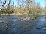
Wide, flat spot and gravel bank below the bridge between Zennern and Obermöllrich
(Artificial) riparian forests on the opposite bank of the river, designated as NSG

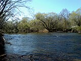
Deep, slow-flowing section of the river with remains of dead wood


Tributaries


Of the good 30 m³ of water that reaches the mouth of the Eder per hour, around 9 come from the Schwalm alone, which drains around 1,300 of the 3,360 km² catchment area ( discharge (Mq) around 7 l / (km² • s)), and again just under So much for the three big Rothaargebirge rivers Orke, Nuhne and Odeborn, which together only need around 520 km² (average discharge around 16, with the Odeborn even around 25). Already a little above the Odeborn estuary, the Eder leads around 3.3 m³ at the Müsse gauge in Aue (results in a discharge of about 26 at 125 km² EZG).
The main tributaries of the Eder are:
Notes on the following table: For a better overview and for sorting downstream , hyphens (-) have been inserted in the DGKZ digits after the number 428, which stands for the Eder . The Eder river kilometers - counted upstream - were calculated from the difference between the Eder length of 176.1 km and the "kilometer stone" of the mouth. Rivers that do not flow directly into the Eder but into the Edersee reservoir are marked with an asterisk (*).
→ List of rivers in the Eder river system
| Surname | location | Length (km) |
EZG (km²) |
Discharge ( MQ ; l / s) |
Estuary (Eder- km ) |
Mouth height ( m above sea level ) |
DGKZ |
|---|---|---|---|---|---|---|---|
| Wahbach | Left | 6.0 | 6.717 | 6.9 | 506 | 428-112 | |
| Benfe | right | 11.2 | 19,446 | 11.9 | 475 | 428-114 | |
| Elberndorfer Bach | Left | 9.0 | 10.733 | 13.6 | 466 | 428-118 | |
| Röspe | Left | 8.6 | 37.013 | 17.7 | 449 | 428-12 | |
| Chapel | Left | 7.3 | 27,443 | 21.8 | 430 | 428-132 | |
| Price Village | right | 6.0 | 8.506 | 14.2 | 420 | 428-1334 | |
| Truffles | Left | 9.7 | 16,576 | 27.1 | 411 | 428-134 | |
| Altmuehlbach | right | 5.3 | 14.459 | 27.9 | 409 | 428-136 | |
| Rinther Bach | right | 6.1 | 9.12 | 30.3 | 403 | 428-138 | |
| Odeborn | Left | 21.2 | 85.064 | 2009 | 31.3 | 400 | 428-14 |
| Grundbach | right | 5.1 | 7.507 | 33.1 | 399 | 428-152 | |
| Lützelsbach | Left | 5.6 | 6.437 | 34.8 | 395 | 428-154 | |
| Leisebach | right | 4.6 | 12.375 | 38.7 | 380 | 428-156 | |
| Arfe | Left | 5.4 | 5.401 | 39.6 | 377 | 428-158 | |
| Lindenhöferbach | right | 4.1 | 12,034 | 189.8 | 48.9 | 349 | 428-1596 |
| Elsoff | Left | 19.0 | 48.925 | 948.1 | 50.0 | 345 | 428-16 |
| Eifaer Bach | right | 4.5 | 7.211 | 103.3 | 54.2 | 342 | 428-172 |
| Riedgraben | Left | 7.6 | 11,319 | 173.4 | 69.0 | 305 | 428-174 |
| Elbrighhäuser Bach | Left | 10.8 | 17.768 | 321.3 | 70.5 | 301 | 428-176 |
| Nitzelbach | Left | 10.6 | 8,397 | 132.4 | 73.7 | 295 | 428-178 |
| Linspherbach | Left | 18.3 | 33.107 | 565.8 | 77.0 | 286 | 428-18 |
| Hainerbach | Left | 7.3 | 10.132 | 103.7 | 80.4 | 280 | 428-192 |
| Goldbach | Left | 9.5 | 13,838 | 155.8 | 84.5 | 273 | 428-1952 |
| Nemphe | right | 14.2 | 38,383 | 293.5 | 86.9 | 270 | 428-198 |
| Nuhne | Left | 36.9 | 156.747 | 2,661.6 | 89.3 | 267 | 428-2 |
| Lengelbach | right | 11.4 | 25.848 | 209.9 | 96.3 | 255 | 428-32 |
| Orc | Left | 38.2 | 278.867 | 3,844.5 | 97.5 | 254 | 428-4 |
| Lorfe | right | 11.8 | 24.281 | 245.7 | 101.4 | 250 | 428-512 |
| Itter * | Left | 11.6 | 76.131 | 771.3 | 105.8 | 247 | 428-531 |
| Aselbach * | Left | 6.6 | 18.103 | 135.4 | 112.4 | 246 | 428-533 |
| Banferbach * | right | 7.2 | 16,383 | 213.9 | 115.2 | 245 | 428-535 |
| Advertising * | Left | 13.2 | 42.263 | 322.6 | 122.2 | 245 | 428-537 |
| Reiherbach * | Left | 7.4 | 27,322 | 188.9 | 122.3 | 245 | 428-538 |
| Networks | Left | 12.9 | 29.04 | 169.5 | 134.0 | 194 | 428-554 |
| Wesebach | right | 25.3 | 63,433 | 618.2 | 135.7 | 191 | 428-56 |
| Savage | right | 17.1 | 51.868 | 471.4 | 140.6 | 183 | 428-58 |
| Elbe | Left | 33.7 | 123.47 | 731.3 | 146.2 | 174 | 428-6 |
| Schwalm | right | 97.1 | 1,298.783 | 9,044.5 | 159.5 | 158 | 428-8 |
| Ems | Left | 34.1 | 146.214 | 753.3 | 164.9 | 151 | 428-92 |
| Pilgrim stream | Left | 8.8 | 25,593 | 102.2 | 175.5 | 145 | 428-98 |
Localities
The villages on or near the Eder include, viewed downstream:
|
on the upper reaches of the Eder:
in Hessen (up to the confluence with the Fulda) :
|
on the middle reaches of the Eder:
|
on the lower Eder:
|
Castles and Palaces
_De_Merian_Hassiae.jpg)
The castles and palaces on or near the Eder include, viewed downstream:
in North Rhine-Westphalia:
- Berleburg Castle , Castle in Bad Berleburg
in Hessen (up to the confluence with the Fulda) :
- Hatzfeld Castle , castle ruins in Hatzfeld
- Kellerburg , castle ruins in Battenberg
- Viermünden Castle , Castle in Viermünden (to Frankenberg )
- Hessenstein Castle , Castle near Ederbringhausen ( near Vöhl )
- Keseburg , castle ruins near Ederbringhausen ( near Vöhl)
- Castle at the oven , castle ruins between Schmittlotheim and Kirchlotheim (zu Vöhl)
- Mückenburg (Mückeburg), castle ruins near Kirchlotheim (zu Vöhl)
- Ehrenburg , castle ruins above the Edersee near Marienhagen (zu Vöhl)
- Hünselburg , castle ruins above the Edersee near Basdorf ( near Vöhl)
- Bring Castle , ruin on the island of love in the Edersee near Bringhausen ( near Edertal)
- Waldeck Castle, castle complex above the Edersee near Waldeck
- Bergheim Castle , Castle in Bergheim (to Edertal )
- Büraburg , castle ruins at Ungedanken (to Fritzlar )
- Altenburg , castle ruins near Altenburg ( near Felsberg)
- Heiligenburg Castle , castle ruins near Gensungen (zu Felsberg)
- Felsburg , castle as a partial ruin in Felsberg
Other rivers close to the source
Near the Eder source are in the Rothaar the sources of two other major rivers: Only 3 km southeast springs from the west to the Rhine flowing victory . The Lahn rises another 2.5 km to the south, flowing largely parallel to the Eder to the east in its upper reaches, but then turning to the south-west and flowing into the Rhine.
history
The Eder is mentioned for the first time by the Roman historian Tacitus in 15 AD as Adrana , located in the area of the Chatten , when crossing it near today's Fritzlar the Romans encountered strong resistance from the Chattas as part of the Germanicus campaigns they then destroyed their main town, Mattium .
It has been a gold- bearing river since the Goldbach confluence near the Frankenberg district of Röddenau at the latest . A large part of the gold is fed to the Eder via the Itter from Eisenberg near Korbach , Central Europe's largest gold deposit. The main historical mining sites are located downstream below the Edertalsperre between Affoldern and Fritzlar. In the 14th century, the Teutonic Order operated gold panning on the Eder near Obermöllrich . In the 18th century, ducats were minted from eder gold, which are now a rarity among collectors. The so-called river gold ducats can be recognized by their inscription, e.g. B. SIC FVLG (ent) LITORA ADRANAE AURI FLVAE (= this is how the banks of the gold leading Eder shine). Even today gold finds of around 1 mm in size are still possible.
On the banks of the Eder in Schwarzenau , in the Wittgensteiner Land , the religious movement of the Schwarzenau Brethren arose in August 1708 after a group of eight adults were baptized in the Eder by immersing themselves three times. After emigrating , this Pietist - Anabaptist movement is now particularly widespread in North America.
Individual evidence
- ↑ a b c d e Topographical Information Management, Cologne District Government, Department GEObasis NRW ( information )
- ↑ a b Topographic map 1: 25,000
- ↑ a b c d Water map service of the Hessian Ministry for the Environment, Climate Protection, Agriculture and Consumer Protection ( information )
- ^ Deutsches Gewässerkundliches Jahrbuch Weser-Ems 2012. Lower Saxony State Agency for Water Management, Coastal Protection and Nature Conservation, p. 141, accessed on October 4, 2017 (PDF, German, 6523 kB).
- ↑ The level is immediately above the mouth of the Kappel.
- ↑ Discharge values at the Müsse gauge , ELWAS (NRW)
- ^ Gerhard Schön: German coin catalog 18th century , (1984), p. 285, no. 149, Hessen-Kassel, Edergolddukat from 1775
literature
- Gerhard Kalden: Nature experience Edertal. From the source to the mouth. Cognitio Verlag, Niedenstein 2007, ISBN 978-3-932583-25-4 .