Beddelhausen
|
Beddelhausen
City of Bad Berleburg
Coordinates: 51 ° 0 ′ 0 ″ N , 8 ° 29 ′ 23 ″ E
|
|
|---|---|
| Height : | 359 (350-560) m |
| Area : | 8.16 km² |
| Residents : | 431 (March 31, 2017) |
| Population density : | 53 inhabitants / km² |
| Incorporation : | 1st January 1975 |
| Postal code : | 57319 |
| Area code : | 02755 |
|
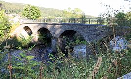
Round arch bridge in Beddelhausen
|
|
Beddelhausen is a village in the Siegen-Wittgenstein district and has also been part of the city of Bad Berleburg since the municipal reorganization in 1975 . Today the village has about 500 inhabitants. Beddelhausen belongs to the Protestant parish Elsoff.
geography
location
Beddelhausen is on the eastern edge of the municipality, 12 km from the city center. Beddelhausen lies in the Ederaue , which is quite wide at this point and crosses the Rothaargebirge , at an altitude of 350-560 meters above sea level. NN. The village extends over both sides of the Eder. The Kalmbracht is the highest mountain in Beddelhausen.
Neighboring places
- Elsoff
- Richstein
- Schwarzenau
- City of Hatzfeld
history
Documentary
Beddelhausen was first mentioned in a document as "Bedelenhusen" in 1059. The spelling of the place name varied over the centuries. The name Beddelhausen could possibly go back to the personal name Bedilo. The place belonged to the Vogtei Elsoff. In contrast to some other Wittgensteiner localities, Beddelhausen has presumably been continuously inhabited by people since its foundation. In 1391 a Heinrich von Beddelnhusen is mentioned who owned shares in an estate in Niederallendorf. The village has belonged to the Richstein family since 1538 and thus to their jurisdiction. The chapel is first mentioned in 1553. 1662 the place belongs to the Vogtei Elsoff and to the office Richstein. From 1819 Beddelhausen is part of the Schwarzenau district of the mayor. In 1845 he was assigned to the Arfeld office.
railroad
On April 1, 1911, the Hatzfeld – Arfeld section of the Bad Berleburg – Allendorf railway was opened. This was used until it was shut down on May 29, 1981. At 17.0 km of the railway near the Lindenhöfer Bach, there was a supplementary station from August 1944, which was used for the production of the V2 rocket (retaliatory weapon 2). Here a crane had been installed over the rails, which was used for handling the individual rocket parts.
Reorganization
On January 1, 1975 the place lost its independence through the municipal reorganization within the framework of the Sauerland / Paderborn Act and became part of the city of Bad Berleburg.
Population development
| development | year | Residents | |||
|---|---|---|---|---|---|
 |
|||||
| 1961 | 464 | ||||
| 1970 | 463 | ||||
| 1974 | 489 | ||||
| 2011 | 505 | ||||
| 2017 | 431 | ||||
|
The 1961 (June 6th) and 1970 (May 27th) figures are taken from the census results. 1974, source from 2011:. From 2017 to December 31 of the year. |
|||||
Attractions
Sights in Beddelhausen include the round arch bridge from the 19th century and the Protestant village church from the 13th century. To the south of the old Eder bridge, in the town's old municipal quarry , there is the slate stone quarry, which has been awarded a National Geotope .
literature
- Bedelenhusen 1059 - Beddelhausen 2009. A picture sheet of the village of Beddelhausen on the occasion of the 950th anniversary , ed. from Heimatverein Beddelhausen eV, 2009
- Günther Wrede : Territorial history of the county of Wittgenstein. NG Elwertsche Verlagbuchhandlung, Marburg 1927.
- Eberhard Bauer: Two pictures from the lower Edertal . In: Wittgenstein. Leaves of the Wittgensteiner Heimatverein , 1967, issue 4, pp. 151–153
- Julius Büscher: A Wittgenstein life saver in 1820 (Re. Gottschalk) . In: Das Schöne Wittgenstein , 1928, issue 3/4, p. 147
- Fritz Krämer: The Elsoffer Peasant War. A contribution to the history of the villages of Alertshausen, Beddelhausen and Elsoff (1721–1729) . In: Wittgenstein. Leaves of the Wittgensteiner Heimatverein , 1968, Issue 1, pp. 45–56; Volume 2, pp. 58-80; Issue 3, pp. 145-163
- Jochen Karl Mehldau : Farms in Beddelhausen 1566–1875 . In: Wittgenstein. Leaves of the Wittgensteiner Heimatverein , 2008, Issue 3, pp. 105–110; Issue 4, pp. 140-158
- Hans Pez: On the history of Beddelhausen . In: Das Schöne Wittgenstein , 1930, no. 2, pp. 72–77
- Matthias Piecha: The silica slate folds near Beddelhausen - a national geotope in the Wittgensteiner Land . In: Wittgenstein. Leaves of the Wittgensteiner Heimatverein , 2006, No. 4, pp. 145–148
- Gustav Schneider: A fire disaster in Beddelhausen . In: Wittgenstein. Leaves of the Wittgensteiner Heimatverein , 1991, Issue 4, pp. 151–153
Web links
- Beddelhausen in the Westphalia Culture Atlas
Individual evidence
- ↑ a b Figures, data, facts - City of Bad Berleburg
- ^ Günther Wrede: Territorial history of the County of Wittgenstein. NG Elwertsche Verlagsbuchhandlung, Marburg 1927, p. 130.
- ↑ a b Federal Statistical Office (ed.): Historical municipality register for the Federal Republic of Germany. Name, border and key number changes in municipalities, counties and administrative districts from May 27, 1970 to December 31, 1982 . W. Kohlhammer, Stuttgart / Mainz 1983, ISBN 3-17-003263-1 , p. 337 .
- ↑ Martin Bünermann, Heinz Köstering: The communities and districts after the municipal territorial reform in North Rhine-Westphalia . Deutscher Gemeindeverlag, Cologne 1975, ISBN 3-555-30092-X , p. 138 .


