Stunzel
|
Stunzel
City of Bad Berleburg
Coordinates: 50 ° 58 ′ 51 ″ N , 8 ° 21 ′ 43 ″ E
|
|
|---|---|
| Height : | 560–620 m above sea level NN |
| Area : | 5.26 km² |
| Residents : | 52 (December 31, 2017) |
| Population density : | 10 inhabitants / km² |
| Incorporation : | 1st January 1975 |
| Postal code : | 57319 |
| Area code : | 02751 |
Stünzel is the smallest district of Bad Berleburg in the Siegen-Wittgenstein district in North Rhine-Westphalia .
Today the village has about 70 inhabitants.
geography
location
Stünzel is on a high plateau at an altitude of 560 to 620 m above sea level. NN. The place is on the European long-distance hiking trail E1 , which leads from the North Cape to the Mediterranean .
Neighboring places
history
The place was first mentioned in a document in 1711. Count Henrich Albrecht zu Sayn-Wittgenstein-Hohenstein (1658–1723) gave permission for the construction of three farms above the village of Weidenhausen . These courtyards were called canon estates. The canon was an annual interest rate. This document is dated November 25, 1711. In 1754 a fourth estate was added. At the beginning of the 19th century there were already ten farms with 90 inhabitants. From 1819 Stünzel belonged to the mayor's district; and from 1845 to the Arfeld office .
Around 1678, a memorial stone, the so-called murder stone, was erected on the Höhenweg in the area of the Stünzel district , reminding of the deliberate killing of a carter.
In 1851, 151 people lived in 21 houses in Stünzel.
On January 1, 1975, the Stünzel community was dissolved. The main part came to Bad Berleburg. An area of 32 hectares, on which 26 people lived at that time, moved to Erndtebrück.
Population development
| development | year | Residents | Residents * | ||
|---|---|---|---|---|---|
 |
|||||
| 1854 | 151 | ||||
| 1900 | 80 | ||||
| 1961 | 74 | 98 | |||
| 1970 | 66 | 94 | |||
| 1974 | 64 | 90 | |||
| 2011 | 66 | ||||
| 2017 | 52 | ||||
|
* with area that was added to Erndtebrück in 1974 The figures for 1961 (June 6th) and 1970 (May 27th) are taken from the census results. 1974, source from 2011:. From 2017 to December 31 of the year. |
|||||
Stünzelfest
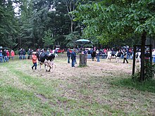
The place Stünzel is known for the annual district animal show, better known regionally as "Stünzelfest". This event always takes place on the second Saturday in June with more than 10,000 visitors. The organizer is the agricultural district association Wittgenstein . A monument above Weidenhausen at the Stünzel junction refers to the association that was founded in 1832 and has been taking care of regional agricultural issues since then. In 2007 the 175th “Stünzelfest” was held.
Individual evidence
- ↑ a b Figures, data, facts - City of Bad Berleburg
- ↑ a b Federal Statistical Office (ed.): Historical municipality register for the Federal Republic of Germany. Name, border and key number changes in municipalities, counties and administrative districts from May 27, 1970 to December 31, 1982 . W. Kohlhammer, Stuttgart / Mainz 1983, ISBN 3-17-003263-1 , p. 337 .
- ↑ Martin Bünermann, Heinz Köstering: The communities and districts after the municipal territorial reform in North Rhine-Westphalia . Deutscher Gemeindeverlag, Cologne 1975, ISBN 3-555-30092-X , p. 138 .
- ↑ Martin Bünermann, Heinz Köstering: The communities and districts after the municipal territorial reform in North Rhine-Westphalia . Deutscher Gemeindeverlag, Cologne 1975, ISBN 3-555-30092-X , p. 138 .
literature
- Festival society “700 years of Weidenhausen” (ed.): Weidenhausen and Stünzel. Once a place - today two villages. Benner printing works, Bad Berleburg 2009.


