Sassenhausen
|
Sassenhausen
City of Bad Berleburg
Coordinates: 50 ° 59 ′ 33 " N , 8 ° 23 ′ 35" E
|
|
|---|---|
| Height : | 550 (520-680) m |
| Area : | 5.96 km² |
| Residents : | 260 (March 31, 2011) |
| Population density : | 44 inhabitants / km² |
| Incorporation : | 1st January 1975 |
| Postal code : | 57319 |
| Area code : | 02751 |
|
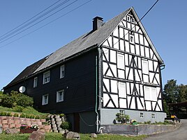
House in Sassenhausen
|
|
Sassenhausen is a district of Bad Berleburg , Siegen-Wittgenstein district , North Rhine-Westphalia .
geography
location
Sassenhausen is located on a ridge between the village of Dotzlar and the city of Bad Laasphe. The highest point is 680 m above sea level. NN the bear head.
Neighboring places
history
The first documentary evidence dates back to the year 1395. In that year, after the knights of Diedenshausen died out, ownership changed to Brosken von Viermünden. In the 16th century the place belongs to the house and district court Richstein . Sassenhausen came from 1819 to the mayor's district and from 1845 to the Arfeld office . The place now has 204 inhabitants, who are spread over 25 houses. In 1900 Sassenhausen had 167 inhabitants.
The place was incorporated into Bad Berleburg on January 1, 1975 as part of the municipal area reform according to the provisions of the Sauerland-Paderborn Act .
Population development
- 1961: 234 inhabitants
- 1970: 221 inhabitants
- 1974: 216 inhabitants
- 2011: 260 inhabitants
religion
Until 1666 the place belonged to the parish Arfeld; Parish to Weidenhausen.
politics
Anke Fuchs-Dreisbach has been the mayor of Sassenhausen since 2009 .
Attractions
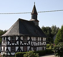
In 1703 the local master carpenter Mannus Riedesel built a school chapel . The construction could be realized solely with the means of the local farmers. The building also served as a church and school building. The former classroom is under the rear gallery. The construction is a pure half-timbered building , which is provided with carvings that are worth seeing.
Web links
- Sassenhausen in the Westphalia Culture Atlas
Individual evidence
- ↑ a b c Federal Statistical Office (ed.): Historical municipality directory for the Federal Republic of Germany. Name, border and key number changes in municipalities, counties and administrative districts from May 27, 1970 to December 31, 1982 . W. Kohlhammer, Stuttgart / Mainz 1983, ISBN 3-17-003263-1 , p. 337 .
- ↑ Martin Bünermann, Heinz Köstering: The communities and districts after the municipal territorial reform in North Rhine-Westphalia . Deutscher Gemeindeverlag, Cologne 1975, ISBN 3-555-30092-X , p. 138 .


