
Hatzfeld (Eder)
| coat of arms | Germany map | |
|---|---|---|
.png)
|
Coordinates: 51 ° 0 ' N , 8 ° 33' E |
|
| Basic data | ||
| State : | Hesse | |
| Administrative region : | kassel | |
| County : | Waldeck-Frankenberg | |
| Height : | 358 m above sea level NHN | |
| Area : | 58.51 km 2 | |
| Residents: | 2940 (Dec. 31, 2019) | |
| Population density : | 50 inhabitants per km 2 | |
| Postal code : | 35116 | |
| Area code : | 06467 | |
| License plate : | KB, FKB, WA | |
| Community key : | 06 6 35 014 | |
| City structure: | 4 city districts and core city | |
City administration address : |
Im Hain 1 35116 Hatzfeld (Eder) |
|
| Website : | ||
| Mayor : | Dirk Junker (independent) | |
| Location of the town of Hatzfeld (Eder) in the Waldeck-Frankenberg district | ||
 _in_KB.svg) |
||

Hatzfeld (Eder) is a town in the Waldeck-Frankenberg district in northern Hesse .
geography
Geographical location
Hatzfeld is located in western Hesse, northwest of Marburg and north of the bagpipe in the Eder valley .
Neighboring communities
Hatzfeld borders the city of Battenberg (Waldeck-Frankenberg district) in the north and east , the city of Biedenkopf ( Marburg-Biedenkopf district ) in the south, and the city of Bad Berleburg (in the Siegen-Wittgenstein district in North Rhine-Westphalia ) in the west .
City structure
Hatzfeld is divided into the districts of Biebighausen , Eifa , Hatzfeld, Holzhausen and Reddighausen .
The districts of the core town of Hatzfeld include the settlements, farmsteads and farmstead groups Ebenfeld , Ederlust, Mühle Elsoff, Lindenhof , Rhoda (Rödchen), Rübighäuser Hof and Schafhort.
history
The Gender those of Hatzfeld is to 1138 as de Hepisvelt first mentioned. Like the neighboring Counts of Battenberg, it was predominantly involved in the Hessian- Mainz disputes during the high and late Middle Ages as a Mainz party member . In 1282 his (now largely dilapidated) castle Hatzfeld is mentioned, at the foot of which a town was built from 1340. After the Hessian line of von Hatzfeld had died out, the town and rule fell half in 1570, and finally in 1588 and 1772, respectively, entirely to the House of Hesse , to which the von Hatzfeld family had given their castle as fief in 1311 .
The statistical-topographical-historical description of the Grand Duchy of Hesse reports on Hatzfeld in 1830:
“Hatzfeld (L. Bez. Battenberg) city; is on the Eder, 2 St von Battenberg, has with the farms Lindenhof, Rödchen, Schaafhort, Elsoff Ebenfeld and Biebighausen, 140 houses and 946 inhabitants, who are Protestant except for 1 Catholics. There are 2 churches, the ruins of the Hatzfeld Castle, 1 town hall, 1 iron hammer, 1 paper mill and on the Edenberg still the remains of an old tunnel. The ruins of Hatzfeld Castle, ancestral home of the still flourishing von Hatzfeld family, are located in Hess in 1351. (1039 par.) Feet above sea level. The iron hammer, which is stately, is located on the Eder 1 ⁄ 2 hour below Hatzfeld, has 2 fires and gets the pig iron from the Ludwigshütte 2 hours away. 3 markets are held annually. - The place appears in earlier times under the name Hatisfeld , also Hapisfeld . The Hatzfeld Castle has given its name to a famous noble family, later counts and princely families. Gottfried and Kraft von Hatzfeld entrusted the castle to Landgrave Otto in 1311, and from that time on they were enfeoffed by Hesse, just as in 1333 Johannes and Guntram von Hatzfeld allowed the Mainz Archbishopric to open their castle. Emperor Ludwig (von Baiern) allowed this family, in 1340, to turn their fortress Hatzfeld into a city, and gave this city all the rights of the city of Frankfurt. "
In 1866 Hatzfeld came to Prussia as part of the Hesse-Darmstadt hinterland and lost its town charter in 1885 according to Prussian law . After the dissolution of Prussia, Hatzfeld regained the designation "city": In November 1950, the Hatzfeld municipality was granted the right to use the designation "city" by the Hessian State Ministry.
Incorporations
In the course of administrative reform in Hesse were voluntarily incorporated : On April 1, 1971, until then independent municipality Holzhausen / Eder; on July 1, 1971 Biebighausen was added. Eifa and Reddighausen followed on January 1, 1974 by virtue of state law. Local districts with local advisory councils and local councilors were formed for all formerly independent municipalities and for the core city .
Territorial history and administration
The following list gives an overview of the territories in which Hatzfeld was located and the administrative units to which it was subordinate:
- around 1282: Holy Roman Empire , rule Hatzfeld with immunity court
- around 1400 and later: Holy Roman Empire, rule of the von Hatzfeld family
- from 1570: Holy Roman Empire, half each ( Landgraviate Hesse , Amt Battenberg and von Hatzfeld family)
- from 1567: Holy Roman Empire, Landgraviate Hessen-Marburg , Amt Battenberg and von Hatzfeld family (from 1602 only 3 ⁄ 8 )
- 1604–1648: disputed between Hessen-Kassel and Hessen-Darmstadt ( Hessenkrieg )
- from 1604: Holy Roman Empire, Landgraviate Hessen-Kassel, Amt Battenberg
- from 1627: Holy Roman Empire, Landgraviate of Hessen-Darmstadt (1772 and 1776 through purchase of all shares), Oberfürstentum Hessen , Amt Battenberg
- from 1806: Grand Duchy of Hesse , Upper Duchy of Hesse, Office of Battenberg
- from 1815: German Confederation , Grand Duchy of Hesse, Province of Upper Hesse , Battenberg Office
- from 1821: German Confederation, Grand Duchy of Hesse, Province of Upper Hesse, District Battenberg
- from 1832: German Confederation, Grand Duchy of Hesse, Province of Upper Hesse, Biedenkopf district
- from 1848: German Confederation, Grand Duchy of Hesse, Biedenkopf district
- from 1852: German Confederation, Grand Duchy of Hesse, Province of Upper Hesse, Biedenkopf district
- from 1867: North German Confederation , Kingdom of Prussia , Province of Hesse-Nassau , District of Wiesbaden , District of Biedenkopf (transitional hinterland district)
- from 1871: German Empire , Kingdom of Prussia, Province of Hesse-Nassau, District of Wiesbaden, District of Biedenkopf
- from 1918: German Empire, Free State of Prussia , Province of Hessen-Nassau, Administrative Region of Wiesbaden, District of Biedenkopf
- from 1932: German Empire, Free State of Prussia, Province of Hessen-Nassau, Administrative Region of Kassel , District of Frankenberg
- from 1933: German Empire, Free State of Prussia, Province of Hessen-Nassau, Administrative Region of Kassel, District of Frankenberg
- from 1944: German Empire, Free State of Prussia, Province of Kurhessen , District of Frankenberg
- from 1945: American zone of occupation , Greater Hesse , Kassel district, Frankenberg district
- from 1949: Federal Republic of Germany , State of Hesse , Kassel district, Frankenberg district
- 1974: Federal Republic of Germany, Land Hessen, Kassel , Marburg-Biedenkopf
population
Population structure
According to the 2011 census , there were 3,078 inhabitants in Hatzfeld on May 9, 2011. Among them were 62 (2.0%) foreigners, of whom 44 came from outside the EU , 12 from other European countries and 6 from other countries. The inhabitants lived in 1307 households. Of these, 398 were single households , 347 couples without children and 443 couples with children, as well as 99 single parents and 20 shared apartments .
Population development
| • 1577: | 96 households |
| • 1712: | 65 households |
| • 1791: | 706 inhabitants |
| • 1800: | 743 inhabitants |
| • 1806: | 686 inhabitants, 120 houses |
| • 1829: | 946 inhabitants, 140 houses |
| Hatzfeld: Population from 1791 to 2015 | ||||
|---|---|---|---|---|
| year | Residents | |||
| 1791 | 709 | |||
| 1800 | 743 | |||
| 1806 | 686 | |||
| 1829 | 946 | |||
| 1834 | 730 | |||
| 1840 | 930 | |||
| 1846 | 1,111 | |||
| 1852 | 1,138 | |||
| 1858 | 1,114 | |||
| 1864 | 1,051 | |||
| 1871 | 985 | |||
| 1875 | 1.002 | |||
| 1885 | 960 | |||
| 1895 | 871 | |||
| 1905 | 902 | |||
| 1910 | 1,040 | |||
| 1925 | 1,090 | |||
| 1939 | 1,161 | |||
| 1946 | 1,578 | |||
| 1950 | 1,536 | |||
| 1956 | 1,519 | |||
| 1961 | 1,494 | |||
| 1967 | 1,556 | |||
| 1972 | 2,088 | |||
| 1975 | 3,370 | |||
| 1980 | 3,343 | |||
| 1985 | 3,374 | |||
| 1990 | 3,315 | |||
| 1995 | 3,427 | |||
| 2000 | 3,413 | |||
| 2005 | 3,349 | |||
| 2010 | 3,250 | |||
| 2011 | 3,078 | |||
| 2015 | 3,029 | |||
| Data source: Historical municipality register for Hesse: The population of the municipalities from 1834 to 1967. Wiesbaden: Hessisches Statistisches Landesamt, 1968. Further sources:; 1972 :; from 1975 :; 2011 census From 1972 including the towns incorporated into Hesse as part of the regional reform . | ||||
Religious affiliation
| • 1829: | 946 Protestant, one Catholic resident |
| • 1885: | 956 Protestant, 4 Catholic residents |
| • 2011: | 2461 Protestant (= 80.0%), 206 Catholic (= 6.7%), 411 other (= 13.4%) residents |
politics
Mayor has been Dirk Junker (independent) since May 1, 2013. On November 18, 2012 Dirk Junker (Hatzfeld citizens 'list) and Ralf Schärer (Reddighausen citizens' list) faced each other in a runoff election. Junker prevailed with 53.2% of the votes cast and a voter turnout of 77.1%. Scherer received 46.8% of the vote.
City Council
The local elections on March 6, 2016 produced the following results, compared to previous local elections:
| Parties and constituencies |
% 2016 |
Seats 2016 |
% 2011 |
Seats 2011 |
% 2006 |
Seats 2006 |
% 2001 |
Seats 2001 |
||
|---|---|---|---|---|---|---|---|---|---|---|
| BLR | Reddighausen Citizens List | 26.7 | 6th | 24.3 | 6th | 24.7 | 6th | 22.0 | 5 | |
| SPD | Social Democratic Party of Germany | 13.8 | 3 | 19.6 | 4th | 19.2 | 4th | 21.6 | 5 | |
| BLH | Citizens' list Hatzfeld | 28.1 | 7th | 15.9 | 4th | 11.3 | 3 | 15.5 | 4th | |
| BLwood | Holzhausen citizens' list | 13.2 | 3 | 14.3 | 3 | 12.7 | 3 | 13.3 | 3 | |
| CDU | Christian Democratic Union of Germany | 10.1 | 2 | 11.2 | 3 | 15.4 | 3 | 17.4 | 4th | |
| BLE | Citizens' list Eifa | 8.1 | 2 | 8.0 | 2 | 9.2 | 2 | 5.0 | 1 | |
| FDP | Free Democratic Party | - | - | 6.8 | 1 | 7.4 | 2 | 5.2 | 1 | |
| total | 100.0 | 23 | 100.0 | 23 | 100.0 | 23 | 100.0 | 23 | ||
| Voter turnout in% | 58.7 | 61.6 | 58.5 | 63.0 | ||||||


coat of arms
At the same time as the granting of the right to use the designation “city”, the Hatzfeld community was granted the right to use a coat of arms according to the draft presented by the Hessian State Ministry in November 1950.
Town twinning
The city of Hatzfeld has had a partnership with Cloyes-sur-le-Loir in the Eure-et-Loir department in France since 1979 .
Culture and sights
City Church of St. John
The Evangelical Lutheran town church St. Johannes is a slab of half-timbered building from the 14th century. The exact year of construction is not known, but the Emmaus Chapel is referred to as the "old" church in a document from 1379, so that the new St. John's Church must have already existed at this time. It was built by the noble family of the “von Hatzfeldt” in the style of a Gothic half-timbered church halfway up the castle hill in the “valley settlement”, which has been granted city rights since 1340. In the choir, hanging above the altar, there is a late Gothic crucifix from the 15th century. It is the second oldest church in town.
Emmaus Chapel
The Emmaus Chapel in Hatzfeld (Eder) is the oldest of the three Hatzfeld churches. Built in the 12th century as a three-aisled late Romanesque pillar basilica with a defensive west tower, it was consecrated to Saint Cyriacus. It belonged to the fortified "Great Court of Nieder-Hatzfeld" - until the castle was built in the late 12th century, this was the ancestral seat of the Lords of Hatzfeld. With the construction of the walled city in the middle of the 14th century, the settlement at this point became extinct. Since then, the chapel has been used as a burial church for the citizens of Hatzfeld. The Hatzfeld organ builder Johann Christian Rindt created an organ with seven registers for the town church in 1706, which was transferred to the Emmaus Chapel in 1868. The important instrument is one of the oldest organs in Hessen.
Catholic Church of St. Hubertus
On the Rath, a rocky outcrop above the Edertal, a small chapel was built in 1898 by Alfred Graf Korff called Schmissing-Kerrsenbrock, Royal Prussian chief forester in Hatzfeld. The passionate hunter named her after St. Hubertus; There is a mighty deer antler above the entrance. After completion, it served as a place of worship for him and his family. The count died in 1936 and was buried in the Hubertus chapel. In addition to the count, two of his children were also buried here.
The count's granddaughter donated the chapel to the Catholic parish in the 1950s, which had it expanded and rebuilt.
Economy and Infrastructure
Land use
In 2015, the municipal area covered a total of 5851 hectares, of which in hectares were:
| Type of use | 2011 | 2015 | |
|---|---|---|---|
| Building and open space | 164 | 166 | |
| from that | Living | 78 | 79 |
| Business | 30th | 20th | |
| Operating area | 18th | 14th | |
| from that | Mining land | 10 | 9 |
| Recreation area | 10 | 10 | |
| from that | Green area | 2 | 2 |
| traffic area | 301 | 301 | |
| Agricultural area | 1310 | 1302 | |
| from that | moor | 0 | 0 |
| pagan | 0 | 0 | |
| Forest area | 3935 | 3943 | |
| Water surface | 82 | 82 | |
| Other use | 32 | 31 | |
Established businesses
The Hollingsworth & Vose company (formerly J. C. Binzer) is based in the core town of Hatzfeld. J. C. Binzer manufactured a wide variety of papers, from writing paper to filters. Since 2001 J. C. Binzer has belonged to the American company Hollingsworth & Vose, which also manufactures paper.
The model railway accessories manufacturer Viessmann Modellspielwaren ( Kibri brand ) is based in the Reddighausen district .
Long-distance cycle routes
The following cycle paths lead along the Eder :
- The 180 km long Eder cycle path begins in the Rothaargebirge in North Rhine-Westphalia and is called here Ederauenweg . The largest part leads through Hesse and is then called the Eder cycle path . It follows the course of the Eder to its confluence with the Fulda near Guxhagen .
- A cycle path on the Orange Route connects the cities of Diez, Nassau, Braunfels, Dillenburg, Siegen and Bad Arolsen, which have been closely linked to the royal family of the Netherlands for many centuries, over around 400 kilometers.
- The Hessian long-distance cycle route R8 (Westerwald – Taunus – Bergstraße) starts in Frankenberg (Eder) and runs for 310 km through the Gladenbacher Bergland , the Westerwald , the Taunus , Frankfurt am Main , the Odenwald to the Bergstraße .
Personalities
sons and daughters of the town
- Adolf Greifenstein (1900–1955), specialist in ear, nose and throat medicine and university professor
- Gustav Schmidt (1898–1972), politician (NSDAP)
Other people in the city
- Helene Elisabeth Countess von Korff called Schmising-Kerssenbrock (1900–1974), grew up in Hatzfeld
- Uwe Ermisch (SPD), mayor from 1989 to 2013, now honorary mayor by unanimous decision of the city council
Location views

Hatzfeld (summer 2006)
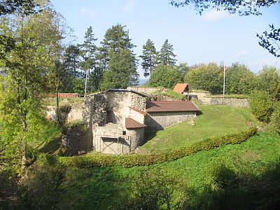
Hatzfeld Castle
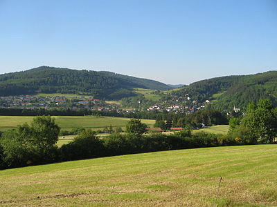
View of Hatzfeld

View of the "Ahlefeld"


literature
- Georg Dehio , Ernst Gall , Magnus Backes : Handbook of German art monuments. Hesse. 2nd edition, special edition, Darmstadt 1982, p. 396.
- Erich Keyser: Hessian city book. Stuttgart 1957, pp. 223-224.
- Rudolf Knappe: Medieval castles in Hessen. 800 castles, castle ruins and fortifications. 3. Edition. Wartberg-Verlag, Gudensberg-Gleichen 2000, ISBN 3-86134-228-6 , pp. 143-144.
- Georg Wilhelm Sante (Hrsg.): Handbook of the historical sites of Germany . Volume 4: Hessen (= Kröner's pocket edition . Volume 274). 3rd, revised edition. Kröner, Stuttgart 1976, ISBN 3-520-27403-5 , pp. 203-204 (reprint 1993).
- Alexander Thon, Stefan Ulrich, Jens Friedhoff : "Decided with strong iron chains and bolts ...". Castles on the Lahn . Schnell & Steiner, Regensburg 2008, ISBN 978-3-7954-2000-0 , pp. 62-65.
Web links
- Hatzfeld, Waldeck-Frankenberg district. Historical local dictionary for Hessen. In: Landesgeschichtliches Informationssystem Hessen (LAGIS).
- Literature about Hatzfeld in the Hessian Bibliography
- Association for Castle and Local History Hatzfeld e. V.
- Link catalog on the subject of Hatzfeld at curlie.org (formerly DMOZ )
- Website of the Ederbergland holiday region
Individual evidence
- ↑ Hessian State Statistical Office: Population status on December 31, 2019 (districts and urban districts as well as municipalities, population figures based on the 2011 census) ( help ).
- ↑ a b c d e f Hatzfeld, Waldeck-Frankenberg district. Historical local dictionary for Hessen. (As of July 5, 2019). In: Landesgeschichtliches Informationssystem Hessen (LAGIS).
- ^ A b c Georg Wilhelm Justin Wagner : Statistical-topographical-historical description of the Grand Duchy of Hesse: Province of Upper Hesse . tape 3 . Carl Wilhelm Leske, Darmstadt August 1830, OCLC 312528126 , p. 114 f . ( Online at google books ).
- ↑ Granting of the right to use the designation "city" to the community of Hatzfeld, Frankenberg / Eder district, Kassel district on November 2, 1950 . In: The Hessian Minister of the Interior (ed.): State Gazette for the State of Hesse. 1950 No. 46 , p. 470 , point 867 ( online at the information system of the Hessian state parliament [PDF; 2.2 MB ]).
- ^ Municipal reform in Hesse: mergers and integrations of municipalities from June 21, 1971 . In: The Hessian Minister of the Interior (ed.): State Gazette for the State of Hesse. 1971 No. 28 , p. 1117 , item 988; Para. 5. ( Online at the information system of the Hessian State Parliament [PDF; 5.0 MB ]).
- ↑ Law on the reorganization of the districts of Frankenberg and Waldeck (GVBl. II 330-23) of October 4, 1973 . In: The Hessian Minister of the Interior (ed.): Law and Ordinance Gazette for the State of Hesse . 1973 No. 25 , p. 359 , § 14 ( online at the information system of the Hessian state parliament [PDF; 2,3 MB ]).
- ^ Federal Statistical Office (ed.): Historical municipality directory for the Federal Republic of Germany. Name, border and key number changes in municipalities, counties and administrative districts from May 27, 1970 to December 31, 1982 . W. Kohlhammer, Stuttgart / Mainz 1983, ISBN 3-17-003263-1 , p. 390-391 .
- ↑ main statute. (PDF; 51 kB) §; 6. In: Website. City of Hatzfeld, accessed March 2019 .
- ^ Michael Rademacher: German administrative history from the unification of the empire in 1871 to the reunification in 1990. State of Hesse. (Online material for the dissertation, Osnabrück 2006).
- ^ Grand Ducal Central Office for State Statistics (ed.): Contributions to the statistics of the Grand Duchy of Hesse . tape 13 . G. Jonghause's Hofbuchhandlung, Darmstadt 1872, DNB 013163434 , OCLC 162730471 , p. 12 ff . ( Online at google books ).
- ↑ The affiliation of the Battenberg office based on maps from the Historical Atlas of Hessen : Hessen-Marburg 1567–1604 . , Hessen-Kassel and Hessen-Darmstadt 1604–1638 . and Hessen-Darmstadt 1567–1866 .
- ↑ a b Grand Ducal Central Office for State Statistics (ed.): Contributions to the statistics of the Grand Duchy of Hesse . tape 13 . G. Jonghause's Hofbuchhandlung, Darmstadt 1872, DNB 013163434 , OCLC 162730471 , p. 27 ff ., § 40 point 6e) ( online at google books ).
- ↑ a b Hessen-Darmstadt state and address calendar 1806 . In the publishing house of the Invaliden-Anstalt, Darmstadt 1806, p. 237 ( online in the HathiTrust digital library ).
- ^ A b Population according to nationality groups: Hatzfeld (Eder), city. In: Zensus2011. Bavarian State Office for Statistics , accessed in March 2020 .
- ^ Households by family: Hatzfeld (Eder), city. In: Zensus2011. Bavarian State Office for Statistics , accessed in March 2020 .
- ↑ Hessen-Darmstadt state and address calendar 1791 . In the publishing house of the Invaliden-Anstalt, Darmstadt 1791, p. 182 ( online in the HathiTrust digital library ).
- ↑ Hessen-Darmstadt state and address calendar 1800 . In the publishing house of the Invaliden-Anstalt, Darmstadt 1800, p. 195 ( online in the HathiTrust digital library ).
- ^ Municipal data sheet : Hatzfeld (Eder). (PDF; 222 kB) In: Hessisches Gemeindelexikon. HA Hessen Agency GmbH
- ^ Local elections 1972; Relevant population of the municipalities on August 4, 1972 . In: The Hessian Minister of the Interior (ed.): State Gazette for the State of Hesse. 1972 No. 33 , p. 1424 , point 1025 ( online at the information system of the Hessian state parliament [PDF; 5.9 MB ]).
- ↑ a b Hessian Statistical Information System In: Statistics.Hessen.
- ^ Religious affiliation : Hatzfeld (Eder), city. In: Zensus2011. Bavarian State Office for Statistics , accessed in March 2020 .
- ↑ Waldeckische Landeszeitung from November 18, 2012 .
- ^ Result of the municipal election on March 6, 2016. Hessian State Statistical Office, accessed in April 2016 .
- ^ Hessian State Statistical Office: Result of the municipal elections on March 27, 2011
- ^ Hessian State Statistical Office: Result of the municipal elections on March 26, 2006
- ↑ Granting of the right to use a coat of arms to the community of Hatzfeld, district of Frankenberg-Eder, reg.-district of Kassel on November 2, 1950 . In: The Hessian Minister of the Interior (ed.): State Gazette for the State of Hesse. 1950 No. 46 , p. 470 , point 871 ( online at the information system of the Hessian state parliament [PDF; 2.2 MB ]).

Allendorf (Eder) | Bad Arolsen | Bad Wildungen | Battenberg (Eder) | Bromskirchen | Burgwald | Diemelsee | Diemelstadt | Edertal | Frankenau | Frankenberg (Eder) | Gemünden (Wohra) | Haina (monastery) | Hatzfeld (Eder) | Korbach | Lichtenfels | Rosenthal | Twist valley | Vöhl | Volkmarsen | Waldeck | Willingen (Upland)
Biebighausen | Eifa | Hatzfeld (Eder) with Lindenhof and Ebenfeld | Holzhausen | Reddighausen