
Odenwald
| Odenwald | |
|---|---|
 |
|
 View from Hochheim am Main to the southeast over the Upper Rhine Plain to the Odenwald. The most striking elevation of the Odenwald silhouette is in the right third of the picture the Melibokus on the Bergstrasse 38 km away. To the right of the Melibokus, the mountain road continues south. |
|
| Highest peak | Katzenbuckel ( 626.8 m above sea level ) |
| location | Hesse , Bavaria , Baden-Wuerttemberg |
| part of | Southwest German layer level country |
| Coordinates | 49 ° 35 ' N , 9 ° 1' E |
| Type | Low mountain range |
| rock | Red sandstone , gneiss , granite , volcanic rocks |
| surface | 2,500 km² |


The Odenwald is one to 626.8 m above sea level. NHN high low mountain range in southern Hesse , Lower Franconia ( Bavaria ) and in northern Baden ( Baden-Württemberg ).
geography
location
The western border of the Odenwald on Bergstrasse stands out impressively from the surrounding area due to the very straight edge of the mountainous area to the Upper Rhine Plain . Over a length of around 65 kilometers between Darmstadt and Wiesloch , suddenly steep mountain slopes rise from a flat plain, which rise several hundred meters high. The northern limit of the mountains is less clearly defined and does not run in a straight line. According to the geographical definition, the northernmost point of the Odenwald is close to the B 26 and the Darmstadt Institute for Botany and Zoology . The boundary of the natural space holds here mostly to the northern strip of woodland, although north then in Reinheimer hills nor mountains of considerable height and distinctive profile as the Otzberg on the subsequent here Untermain level rise. In the east, the Main Valley draws a clear borderline to the Spessart over 33 kilometers from Großwallstadt to Bürgstadt . Then the border line, following the Erfa , continues in a south-easterly direction to Hardheim , the easternmost town in the Odenwald. From here on, the federal road 27 running in a south-westerly direction via Walldürn and Buchen to Mosbach roughly separates the Odenwald from the neighboring building land . The Odenwald breakthrough valley of the Neckar begins in the Mosbach area with its northern turning point at Eberbach , the impressive double Neckar loop at Hirschhorn and the exit into the Upper Rhine Plain at Heidelberg; However, the southern Odenwald border does not follow this natural line, because south of the Neckar the so-called Small Odenwald is still part of the low mountain range , which meets the Kraichgau from Mosbach to Wiesloch in the west . This boundary is also drawn differently, like that to the building land or to the sub-mine level. The two nature parks Bergstrasse-Odenwald and Neckartal-Odenwald therefore protrude further south than the natural area.
The Odenwald is subdivided by the roughly north-south running valley landscapes of the Weschnitz and Gersprenz valley in the front Odenwald and the Mümling valley in the rear Odenwald. The main watershed of the mountains separates the Neckar and Main catchment areas.
The north and west of the Odenwald belong to southern Hesse , in the north-east a small part is in Bavarian Lower Franconia , and in the south it extends into Baden . The Odenwald is therefore also referred to as the Hessischer Odenwald , Badischer Odenwald and Franconian Odenwald , depending on the region belonging to the state .
Political structure
In the middle of the Odenwald lies the Odenwaldkreis with its seat in Erbach . It is the only district that lies entirely in this low mountain range. Other districts also include a more or less large portion of the landscapes surrounding the Odenwald. In the west of the Odenwald lies the Bergstrasse district with its headquarters in Heppenheim , and in the north the Darmstadt-Dieburg district with its headquarters in Dieburg and Darmstadt- Kranichstein . In the north-west an Odenwald ridge extends into the urban area of Darmstadt and in the north-east the northernmost foothill of the mountains reaches the municipality of Großostheim in the district of Aschaffenburg . The district of Miltenberg with its seat in Miltenberg occupies the east, the Neckar-Odenwald district with its headquarters in Mosbach and the south and southwest of the Rhine-Neckar district with its administrative headquarters in Heidelberg. The district of Heidelberg is also partly part of the Odenwald. The Main-Tauber district with its seat in Tauberbischofsheim has a special status in the Far East . The triangle there in Wertheim - Freudenberg - Külsheim lying Wertheimer plateau is indeed defined natural area as part of the Spessart, but commonly attributed to the Odenwald, as she and south of the Main is on the left. Only in this popular view does the Main-Tauber district have a share in the Odenwald.
Natural structure
The Odenwaldtherme forms in geological and geo-morphological respect together with the Spessart as well as the once separated therefrom by Talungen landscapes Büdinger forest and Südrhön a unit that nature spatially than 3. Large Region Procedure 14 (code by numbering of the BfN : D55) Odenwald, Spessart and Südrhön is combined. The Odenwald as part of this large landscape to the left of the Main is divided primarily into the sandstone Odenwald (" Buntsandstein-Odenwald ") and the Vorderen Odenwald (" Crystalline Odenwald ").
The following sub-natural areas are identified:
-
(to 14) Odenwald
-
(to 141 Sandstone Spessart )
- 141.1 Wertheim plateau (157 km²; Wannenberg : 481.2 m )
- 144 sandstone forest (1797.3 km²)
- 144.1 / 2 Kleiner Odenwald (two spatially separate natural areas)
- 144.1 Western Kleiner Odenwald ( Königstuhl : 567.8 m )
- 144.2 Eastern Little Odenwald
- 144.3 Odenwald-Neckartal (valley of the Neckar )
- 144.4 Lohrbach preliminary stages
- 144.5 Winter breath ( cat hump : 626 m ; hard : 580.8 m )
- 144.6 Central Sandstone Odenwald (Hinterer Odenwald)
- 144.60 Southern sandstone forest (Neckar side valleys; boot height : 584 m ; Salzlackenkopf : 576.1 m ; Stillfüssel : 568.4 m )
- 144.61 Eastern divided sandstone forest (Main side valleys; Hohwald : 552.8 m )
- 144.62 Beerfelder Platte ( Krähberg : 554.9 m )
- 144.63 Würzberger Platte ( Kohlwald : 560.4 m )
- 144.64 Sellplatte ( rim forest south of Vielbrunn : 483.9 m )
- 144.65 Wegscheidekamm (at the Wegscheide ; southern summit Spessartskopf : 552.3 m )
- 144.66 Mossausenke (valley of the Mossau and ridge between Mossau and Mümling; Geisberg : 441.2 m )
- 144.67 Eichelsberge ( Zellerkopf : 354.6 m )
- 144.68 Breuberg-Odenwald (to Breuberg Castle ; Old Height : 358.1 m )
- 144.69 Mümlingtal (valley of the Mümling )
- 144.7 Mudtal (valley of the Mud with side valleys)
- 144.70 Upper Mudtal
- 144.71 Lower Mud Valley
- 144.8 Foreland of the rear Odenwald
- 144.9 Erfatal (valley of the Erfa )
- 144.1 / 2 Kleiner Odenwald (two spatially separate natural areas)
- 145 Vorderer Odenwald (591.6 km²)
- Eastern and southern crystalline Odenwald, from south-southwest to north-northeast
- 145.1 Eichelberg-Odenwald (southernmost part of the crystalline Odenwald; Eichelberg : 524.9 m )
- 145.4 Tromm-Odenwald (eastern edge of the crystalline Odenwald at the interface with the sandstone forest; Hardberg : 593.1 m ; Tromm : 576.8 m )
- 145.9 Böllstein-Odenwald (northeast extension of the Tromm-Odenwald; Heidelberg : 443.1 m )
- Weschnitz-Gersprenz-Senke, from south-southwest to north-northeast
- 145.3 Weschnitz Valley (see Weschnitz )
- 145.8 Gersprenztal (valley of the Gersprenz )
- Northwestern Odenwald
- 145.0 Melibokus-Odenwald
- 145.00 Melibokus massif ( Melibokus : 517.4 m )
- 145.01 Frankenstein massif ( Langenberg : approx. 430 m )
- 145.02 Hochstädter Senke (running across the river valleys in north-south direction, east 145.00 / 01)
- 145.03 Felsberg massif ( Felsberg : 514 m )
- 145.04 Neutscher Ridge (at the Neutscher Höhe ; up to 400 m )
- 145.05 Lautertal (valley of the Lauter ; southern edge valley of the Melibokus-Odenwald)
- 145.06 Upper Modautal (valley of the Modau ; eastern edge valley of the Melibokus-Odenwald)
- 145.07 Lower Modautal ("Mühltal"; northern mountain edge)
- 145.08 Trautheimer Wald ( Kirchberg ): ( 280.9 m )
- 145.09 Darmstadt-Bessunger Back (northern spur of the Trautheim Forest in Darmstadt)
- 145.2 Juhöhe-Odenwald (at the Juhöhe pass : 371 m ; Steinkopf : 402.1 m )
- 145.5 Krehberg-Odenwald ( Krehberg : 575.7 m )
- 145.6 Neunkircher-Höh-Odenwald ( Neunkircher Höhe : 605 m )
- 145.7 Lichtenberger Höhen ( Altscheuer : 376.2 m )
- 145.0 Melibokus-Odenwald
- Eastern and southern crystalline Odenwald, from south-southwest to north-northeast
-
(to 141 Sandstone Spessart )
The merging valleys of Weschnitz (145.3) and Gersprenz (145.8) separate, within the crystalline Odenwald, an orographic north-western part of the low mountain range, which orographically divides into 3 larger segments and a small one. The actual Melibokus-Odenwald (145.00-04) in the north-west is separated from the main part by the valleys of Lauter (145.05) and Mud (145.06 / 07); in the extreme western north, the Mühltal (145.07) separates the Trautheim Forest, which takes up little space, and its foothills (145.08 / 09). The Juhöhe-Odenwald (145.2) is also orographically separated as a southern part within the northwestern Odenwald by a depression that merges from the Heppenheimer Stadtbach to the east into the side valleys of the Weschnitz.
Across the Weschnitz-Gersprenz-Senke, Eichelberg- (145.1), Tromm- (145.4) and Böllsteiner (145.9) Odenwald merge into the sandstone Odenwald without any significant differences in altitude.
The red sandstone area south of the Main is divided in the extreme south by the valley of the Neckar (144.3), which separates the Kleiner Odenwald (144.1 / 2); in the north-east, the Erfa valley (144.9) separates a small north-east part, the Wertheim plateau (141.1), which is already part of the Sandstone Spessart.
Sandstone Odenwald
The sandstone Odenwald still bears the sedimentary cover from the red sandstone period over the Varisk basement . This part of the mountain range is very deep, the frequent elongated ridges show the "coffin lid" shape. The Odenwald sandstone is mined in quarries near Beerfelden .
Crystalline Odenwald
In the western part of the Odenwald the erosion has already exposed the crystalline basement, caused by the stronger tectonic uplift on the eastern edge of the Upper Rhine Rift. A great variety of rocks occurs here: Metamorphic rocks , mainly in the form of gneisses , are just as represented as plutonites ( granite , diorite and gabbro ) or rocks of volcanic origin such as rhyolite ("quartz porphyry") or basalt .
mountains


The mountains of the Odenwald include - sorted by height in meters (m) above sea level (MSL; unless otherwise stated according to):
Over 600 m:
- Katzenbuckel (626.8 m; observation tower), Waldkatzenbach , Neckar-Odenwald district, Baden-Württemberg
- Neunkircher Höhe (605.0 m; Kaiserturm ( AT )), Bergstrasse district, Hesse
Over 500 m:
- Hardberg (593.1 m; Hardberg transmission tower ), Unter-Abtsteinach and Siedelsbrunn , Bergstrasse district, Hesse
- Markgrafenwald (584.5 m) Mülben , Neckar-Odenwald district, Baden-Württemberg
- Boot height (584.0 m), Unter-Abtsteinach , Bergstrasse district, Hesse
- Hart (580.8 m; Reisenbach telecommunications tower ), Mudau - Reisenbach , Neckar-Odenwaldkreis, Baden-Württemberg
- Salzlackenkopf (577.7 m), Mudau -Reisenbach, Neckar-Odenwaldkreis, Baden-Württemberg
- Tromm (576.8 m; Ireneturm ( AT )), Kocherbach , Bergstrasse district, Hesse
- Krehberg (575.7 m; Krehberg transmitter ), Seidenbuch , Bergstrasse district, Hesse
- Königstuhl (570.3 m; observatory , Max Planck Institute for Astronomy , funicular railway ), City of Heidelberg , Baden-Württemberg
- Stillfüssel (568.4 m), Unter-Schönmattenwag , Bergstrasse district, Hesse
- Reisenberg (567.8 m), Mudau-Reisenbach , Neckar-Odenwald district, Baden-Württemberg
- Dickbuckel (564.0 m), Oberscheidental , Neckar-Odenwaldkreis, Baden-Württemberg
- Kohlwald (560.4 m), Bullau , Odenwaldkreis, Hesse
- Sensbacher Höhe (557.8 m), Ober-Sensbach , Odenwaldkreis, Hesse
- Krähberg (554.9 m), Ober-Sensbach , Odenwaldkreis, Hesse
- Gickelsberg (554.0 m), Unter-Sensbach , Odenwaldkreis, Hesse
- Kinzert (553.3 m), Schloßau , Neckar-Odenwald district, Baden-Württemberg
- Hohwald (552.8 m), Schloßau, Neckar-Odenwald district, Baden-Württemberg
- Schildenberg (552.3 m), Kailbach , Odenwaldkreis, Hesse
- Spessartskopf (552.3 m), Gras-Ellenbach , Bergstrasse district, Hesse
- Hohe Warte (551.3 m), Eberbach , Rhein-Neckar-Kreis, Baden-Württemberg
- Weißer Stein (548.9 m; Weisser-Stein Tower ( AT ), telecommunications tower), Dossenheim , Rhein-Neckar district, Baden-Württemberg
- High Longhouses (548.3 m), Hesselbach , Odenwaldkreis, Hesse
- The package (548.0 m), ( border triangle of Bavaria, Baden-Württemberg and Hesse): Markt Kirchzell , district Miltenberg (mountain peak and main part), Mudau -Mörschenhardt, Neckar-Odenwald district (southern part) and Oberzent , Odenwald district, Hesse (western part)
- Falkenberg (546.1 m), Unter-Sensbach , Hesse
- Raupenstein (545.3 m), Winterkasten , Bergstrasse district, Hesse
- Roter Buckel (540.2 m), Würzberg , Michelstadt, Odenwaldkreis, Hesse
- Dossenheimer Kopf (539.0 m), Heidelberg - Peterstal , Rhein-Neckar-Kreis, Baden-Württemberg
- Meisenberg (538.4 m), Aschbach , Bergstrasse district, Hesse
- Waldkopf (538.0 m), Löhrbach , Bergstraße district, Hesse
- Knörschhügel (536 m), Knoden , Bergstrasse district, Hesse
- Wagenberg (535.7 m), Fürth and Hammelbach , Bergstrasse district, Hesse
- Das Buch (535.3 m), Lindenfels , Bergstrasse district, Hesse
- Kesselberg (531.1 m), Ober-Hambach , Bergstrasse district, Hesse
- Schriesheimer Kopf (529.2 m; Teltschikturm ( AT )), Wilhelmsfeld , Rhein-Neckar-Kreis, Baden-Württemberg
- Kleiner Meisenberg (527.8 m), Affolterbach , Bergstrasse district, Hesse
- Eichelberg (525.3 m; Eichelbergturm ( AT )), Weinheim - Oberflockenbach , Rhein-Neckar district, Baden-Württemberg
- Kohlich (approx. 525 m), Breitenbuch , Bavaria
- Götzenstein (521.9 m), Löhrbach , Bergstrasse district, Hesse
- Kahlberg (520.6 m), Fürther Zentwald, Bergstrasse district, Hesse
- Elseberg (518.0 m), Hetzbach , Oberzent, Odenwaldkreis, Hesse
- Melibokus (Malschen) (517.4 m; observation tower), Zwingenberg , Bergstrasse district, Hesse
- Morsberg (516.7 m), Kirch-Beerfurth , Odenwaldkreis, Hesse
- Felsberg (514.0 m; Ohly Tower ( AT ), Felsenmeer Lautertal ), Reichenbach , Bergstrasse district, Hesse
- Knodener Kopf (511.2 m), Knoden , Bergstrasse district, Hesse
- Schnuppenberg (506.9 m), Unter-Sensbach , Odenwaldkreis, Hesse
- Noise fire (501.7 m), Ober-Mossau , Odenwaldkreis, Hesse


Over 400 m:
- Emichskopf (500.0 m), Boxbrunn , Miltenberg district, Bavaria
- Rimdidim (498.5 m), Fischbachtal , Darmstadt-Dieburg district, Hesse
- Kleiner Knöschen ( gypsy pit; 497.3 m), Olfen , Odenwaldkreis, Hesse
- High Nistler (496.1 m), City of Heidelberg , Baden-Württemberg
- Eselskopf (495.0 m), sub-Mossau, Mossautal , Odenwaldkreis, Hesse
- Welchel (492.1 m), Rothenberg , Odenwaldkreis, Hesse
- Dachsberg (Mossautal) (481.8 m), Hiltersklingen, Mossautal , Odenwaldkreis, Hesse
- Wannenberg (481.2 m), Bürgstadt , Miltenberg district, Bavaria
- Schenkenberg (approx. 480 m), Lindenfels , Bergstrasse district, Hesse
- Hartenbühl (473.0 m), Dossenheim / Schriesheim , Rhein-Neckar district, Baden-Württemberg
- Schindbuckel (approx. 473 m), Oberzent , Odenwaldkreis, Hesse
- Daumberg (462 m), Gorxheimertal- Trösel, Bergstrasse district, Hesse
- Hohe Waid (458.3 m), Schriesheim and Leutershausen , Rhein-Neckar-Kreis, Baden-Württemberg
- Steinkopf (451.0 m), Fischbachtal , Darmstadt-Dieburg district, Hesse
- Mount of Olives (449.3 m), Schriesheim , Rhein-Neckar district, Baden-Württemberg
- High Darsberg (445.0 m), Neckarsteinach , Bergstrasse district, Hesse
- Heiligenberg (439.9 m), City of Heidelberg , Baden-Württemberg
- Langenberg (approx. 430 m) with the southern summit (421.6 m), between Mühltal and Seeheim-Jugenheim , Darmstadt-Dieburg district, Hesse
- Ilbes-Berg (419.7 m; magnetic stones ; on the northern foothills of the Schloßberg (approx. 370 m) with Frankenstein Castle ), Nieder-Beerbach , Darmstadt-Dieburg district, Hesse
- Hahlkopf (416.0 m), Fischbachtal , Darmstadt-Dieburg district, Hesse
- Allertshofer Tanne (405.0 m), south of the Neutscher Höhe mountain pass ( 360 m ), Darmstadt-Dieburg district, Hesse
- Knorz (404.5 m), Lautern , Bergstrasse district, Hesse
Over 300 m:
- Schreckskopf (394.9 m), Fischbachtal , Darmstadt-Dieburg district, Hesse
- Spitzer Stein (380.3 m), Fischbachtal , Darmstadt-Dieburg district, Hesse
- Altscheuer (376.2 m), Fischbachtal , Darmstadt-Dieburg district, Hesse
- Otzberg (367.9 m; Veste Otzberg ), Hering , Darmstadt-Dieburg district, Hesse
- Wendenkopf (359.6 m), Schriesheim , Rhein-Neckar district, Baden-Württemberg
- Auerberg (345.9 m; Auerbach Castle ), Auerbach , Bergstrasse district, Hesse
- Hirschkopf (345.7 m; Hirschberg Tower ( AT ), Weinheim transmitter ), Weinheim , Rhein-Neckar district, Baden-Württemberg
- Goldkopf (323.3 m), Weinheim , Rhein-Neckar district, Baden-Württemberg
- Breuberg (approx. 306 m; Breuberg Castle ), Breuberg , Odenwaldkreis, Hesse
- Gotthardsberg (304 m), Amorbach , Miltenberg district, Bavaria
panorama

View from the observation tower on the Katzenbuckel over the Odenwald

Waters
Flowing waters
Numerous flowing waters have their source in the Odenwald , the longest of which are:


- Weschnitz (60 km), tributary of the Rhine , at the Biblis nuclear power plant
- Gersprenz (51 km), tributary of the Main , near Mainhausen
- Mümling (50 km), tributary of the Main, near Obernburg am Main
- Lauter (43 km), tributary of the Rhine, near Gernsheim
- Modau (42 km), tributary of the Rhine, on the edge of the Kühkopf-Knoblochsaue near Stockstadt am Rhein
- Erf (40 km), tributary of the Main, near Bürgstadt
- Elz ( Elzbach ) (34 km), tributary of the Neckar , near Neckarelz
- Mud (24 km), tributary of the Main, in Miltenberg
- Steinach (22 km), tributary of the Neckar, near Neckarsteinach
- Itter ( Itterbach ) (21.2 km), tributary of the Neckar , which flows into Eberbach and whose main upper reaches flows through the Eutersee
- Finkenbach (20.5 km), confluence in Hirschhorn with the Ulfenbach to Laxbach, a short tributary of the Neckar there
- Ulfenbach (19.1 km), confluence in Hirschhorn with the Finkenbach to Laxbach, a short tributary of the Neckar there
- Trienzbach (approx. 16 km), tributary of the Elz, rises between Langenelz and Scheidental , flows through Trienz to Dallau
- Gammelsbach (15 km), tributary of the Neckar, flows from Beerfelden through Gammelsbach to Eberbach
- Welzbach (14.2 km), tributary of the Main, flows from its source near Radheim through the Bachgau to Leider
- Meerbach (13 km), tributary of the Weschnitz, near Lorsch
- Grundelbach (10 km), tributary of the Weschnitz, flows from Trösel to Weinheim
- Mutterbach (7.7 km), tributary of the Main, near Wörth am Main
Still waters
The few still waters in the Odenwald include (with water areas in ha ):
- Marbach reservoir (49 to 22 ha), on the Marbach , near Ebersberg
- Large lake and small lake (3.3 and 1.1 ha, respectively) in the spa gardens in Bad König
- Eutersee (0.9 ha), on the Euterbach , near Schöllenbach
geology

The Odenwald is divided mineralogically into the western crystalline Odenwald and the eastern Buntsandstein-Odenwald , which mainly consists of sedimentary rock . Overall, the geological history of the Odenwald is divided into three main sections:
- Variscan Mountains: About 380 to 320 million years ago, in the Devonian and Carboniferous , various dwarf continents pushed together and unfolded the Variscan Mountains . Most of the rocks of the western crystalline Odenwald originated during this time or are remelted old stocks.
- Sedimentation: The mountains were eroded down to a wavy hull. On this area, which was sometimes flooded by the ocean and torn up by volcanic eruptions , thick layers of limestone and sand were deposited around 260–65 million years ago - especially in the Mesozoic era . a. the red sandstones of the eastern Odenwald.
- Today's landscape: About 45 million years ago, with the lowering of the Upper Rhine Rift in the Tertiary, the development of today's landscape began. Rivers cut deeply into the rocks and carried away the debris. The crystalline mountain base was exposed in the west, parts of the red sandstone formation remained in the east.
Variscan Mountains
Mountain formation as a result of continental drift
The composition and genesis of the crystalline mountains are quite complicated, and its geological map resembles a patchwork quilt. As part of the Mitteldeutschen crystalline zone (MDKZ) which extends in an arc to the Thuringian Forest, originated in the Palaeozoic ( Paläozoikum ) on the one Granitoids for other high-pressure rocks such Eclogites (the carbon ), both represent " recycled " crust. The size and distribution of the continents at that time differed greatly from their current state: "Central Europe" was located in an ocean area south of the equator and consisted of small continents. Due to the continental drift, a southern continent drifted towards a northern continent. That is why the “Central European” dwarf continents in between collided, and in the Devonian and Carboniferous periods the Variscan Mountains rose on and between them, to which the Odenwald also belongs. In research, an island arc scenario with mountain formation as a result of a subduction zone as it exists today in the East Asian Pacific coast region is being discussed for the MDKZ . After that, the old rocks were first sunk deep into the earth's crust (subduction) and melted at a depth of around 15 kilometers in the upper mantle , then slowly pushed back up into the earth's crust together with magma rocks , where they gradually cooled and crystallized over the course of 60 million years.
Tripartite division of the crystalline Odenwald
Current research divides the crystalline Odenwald according to the tectonic - metamorphic processes into three units separated by fault zones ( strike-slip zones):
- Böllsteiner Odenwald ,
- Frankenstein complex and
- Bergstrasse Odenwald.
These three units, which have a common sedimentation , were metamorphically overprinted in the Devonian about 400 to 375 million years ago under similar temperature and pressure conditions. However, tectonic processes (expansion) separated these units, so that they continued to develop independently in their magmatism and the metamorphoses they passed through.
- The Böllsteiner gneiss emerged from granitoids that penetrated into older sediments from below as rock melts about 410 million years ago . As a result of the pushing together, these were sunk into deeper areas of the earth's crust and transformed into slates and gneisses at high temperatures and high pressure .
- The Frankenstein Complex is the oldest igneous rock in the western Odenwald. The gabbros and diorites intruded in the Upper Devonian about 362 million years ago.
- In the Bergstrasse Odenwald, which extends as far as Heidelberg , the crystalline associations are younger and spatially more uniform compared to the Frankenstein gabbro:
- the granodiorite of the → Weschnitzplutons (Lower Carboniferous, about 333 to 329 million years ago)
- the → drum granite penetrating to the east about 320 million years ago and
- the related → Heidelberg Variations in the southern Odenwald.
These complexes are stuck between metamorphosed old stocks, e.g. B. the slate and gneiss in the → Flasergranitoidzone (from Heppenheim / Bensheim in the Ore Mountains direction NE to the Otzberg fault). interprets the processes in these mixed areas magmatically, especially in the southern part. According to this, various magma bodies are said to have risen in a short period of time ( nested diapirs ); In the northern border area to the Frankenstein massif, he suspects a tectonic overprinting - shear movements of the rock formations are said to have led to melting (dynamic contact metamorphosis ), mutual infiltration and reshaping of neighboring areas, which then formed similar crystalline-metamorphic structures. Such zones have also developed between Weinheim and Wald-Michelbach . The Auerbach marble train , a special case, was created by heating and chemical reaction between adjacent limestone and silicate stones . During the tectonic processes, cracks repeatedly tore open in the rock mass, into which u. a. ore-containing melts penetrated, which then crystallized into gangue rocks. Examples of this are the quartz and barite veins near Reichenbach and Balzenbach. Younger aplitic granites shattered older granodiorite or biotite granite stocks. In the further course of the plate movements, the Böllstein gneiss and the Bergstrasse complexes, separated by an old fault zone - the Otzberg cleft - were pushed together and welded by the drum granite.


volcanic eruptions
Great tremors in the earth's crust shook the Odenwald in the time of the Upper Rotliegend about 260 million years ago. Volcanoes emerged from the earth at old fault zones , especially in the area around Weinheim (Wachenberg, Daumberg ), Schriesheim / Dossenheim (290 to 270 million years ago) and Heidelberg, hurled tuffs from their craters and poured lava onto the earth's surface - the granite gneiss -Mountains were meanwhile already worn down to the base. In the rhyolite quarry in Weinheim, the solidified chimney filling of the Wachenberg volcano is processed into gravel. On the other hand, in the Schriesheim and Dossenheim quarries, the quarrying of the quartz porphyry ceilings on the granite hull has now ceased. The point at which the volcano that promoted the effusion rocks erupted was probably in the area of today's Rhine Graben and sank with the local rocks when it collapsed. Remnants of the Rotliegend are preserved around Schriesheim and in Sprendlinger Horst.
Erosion and deposits (sedimentation)
In the early Permian era , the Zechstein Sea flooded the region and covered it with deposits that are important for ore mining: dolomites , into which iron and manganese-containing quartz solutions later penetrated. The history of sedimentation continues in the Mesozoic (Mesozoic Age) between 250 and 65 million years with the deposit of up to 600 m thick red sandstone, shell limestone , Keuper and Jura layers.
Creation of today's landscape
Lowering of the Upper Rhine Rift

A long time later, there were again strong movements in the earth's crust in Central Europe: In connection with a rift zone from the Mediterranean to the North Sea , the Upper Rhine Rift broke in places up to 3.5 km in the Tertiary about 45 million years ago (end of the Tertiary: up to 4 km) and was immediately filled by sliding the surface at that time. This reduction continues to the present, at Darmstadt at a rate of around 0.2–0.4 mm per year. To compensate for this, the adjacent mountains rose by up to 2.5 km, but with the uplift the erosion began. As a result, many cross and transverse clefts divided the area of today's Odenwald into mountain blocks and ditches. A consequence of the subsidence are also slight earthquakes in the northwest of the Odenwald. These go beyond microquakes , are noticeable and can lead to slight damage. On May 17, 2014 at 6:48 p.m. (CEST), an earthquake with a magnitude of 4.2 on the Richter scale struck Nieder-Beerbach. The hypocenter was about six kilometers deep. The quake caused numerous minor damage to buildings. It was part of a series of weak earthquakes in the area southeast of Darmstadt since March 2014.
Volcanism
Magma penetrated to the surface before and formed basalt - volcanoes : In addition to the before 68 million years ago resulting in the Cretaceous Katzenbuckel which erupted again about 40 million years, are among those in the central and northern Odenwald about the Rossberg (before 52 million years ) and the Otzberg (around 35 to 20 million years ago).
Weathering and erosion
- Because the warm, humid tertiary climate favored weathering and erosion, the streams cut deep into the terrain, sawed the mountain massifs and cleared the debris. A layered landscape developed , and the steps of the mighty Keuper, Muschelkalk and Zechstein formations were gradually moved back to the southeast. Remnants of shell limestone with karstification phenomena such as Erdbach infiltration can be found in the Mümlinggraben near Michelstadt .

- The landscape in the eastern Odenwald is only determined by the red sandstone deposits, at the edge of which the Zechstein layer underneath with its iron and manganese ores was accessible for mining. B. in the area east of Reichelsheim and in Wald-Michelbach. Just like the Muschelkalk, Keuper and Jura sediments, the volcanic cover has been almost completely removed. The basalt columns on the castle hill, which are remains of the crater filling, have been preserved on the Otzberg . The erosive forces exposed the crystalline mountain hull again, rivers and streams shifted their course in orientation to old fault zones (Gersprenztal, upper Ulfenbachtal) or cleared the debris in the basin-like, weathered Weschnitz valley , where gravel deposits up to 30 m high were located. Mountains and slopes were torn into blocks, which were then rounded off to form spherical structures by chemical weathering ( wool sack weathering ).
- In the subsequent Ice Age , the Odenwald had a permafrost climate, so the ground was constantly deeply frozen. When it warmed up (at the end of the Ice Age), the upper layer thawed and the rocks, freed from the rubble, slid down the slope and gathered in the valley floor to form a sea of rocks (near Reichenbach or on the Krehberg , but also in the Buntsandstein-Odenwald in the Katzenbuckel region). This is how the characteristic modern low mountain range landscape of the Odenwald was created.
Mining
The geological processes have created numerous minerals and ores. Marble ( Auerbacher marble ) and porphyry ( Dossenheim ) were quarried until modern times . In the southwest of the Odenwald silver, lead and copper ores have been mined since the Middle Ages, while in the eastern part of the Buntsandstein-Odenwald mining of iron and manganese ores dominated. Most of the companies became unprofitable with the advent of blast furnaces , because they needed large amounts of hard coal, which does not occur locally. The low content and the poor purity of the ores and the poor transport connections until the Odenwald Railway was built were also disadvantageous. There are three visitor mines in the Odenwald: Grube Anna-Elisabeth ( Lage ) near Schriesheim , Grube Marie in der Kohlbach ( Lage ) near Weinheim and Grube Ludwig ( Lage ) near Wald-Michelbach .
history
.jpg)


prehistory
The earliest settlement of the Odenwald can be traced through end-Neolithic archaeological finds. Older finds of the band ceramics are only found in the northern (Gersprenz), western ( Juhöhe ) and southern (Neckar valley) peripheral areas of the Odenwald. One of the oldest finds is a stool grave , which was found under the courtyard wall of the later Roman Villa Haselburg near Hummetroth. Numerous tool finds in the area of the Kinzig valley (outside the Odenwald) prove that there was settlement at this time. They were collected privately and are now considered collection Black in Breubergmuseum on the Burg Breuberg and in the City Museum in Michelstadt . There are no settlement finds from the Bronze Age . However, numerous burial mounds have been preserved along the river valleys, especially in the central Mümling valley . They are characteristically on the heights above the valley basins.
In the Hallstatt and early La Tène periods , these burial mounds were used again for subsequent burials and new ones were built. Such a tomb is known from the courtyard of the Roman Villa Haselburg. The burial mound contained two burials from the early Celtic period (4th / 3rd century BC) with costume components made of iron and bronze, including a washer collar with coral inlays . But there is no indication whether the hill was still visible in Roman times. Another important find of this time is the so-called Raibacher Bild , an anthropomorphic sandstone stele that was found in 1919 on Obersberg near Breuberg- Rai-Breitenbach. It is now in the Hessisches Landesmuseum Darmstadt , a copy is on display in the Breubergmuseum.
Finds from the Celtic late Latène period are almost completely missing in the Odenwald. It is possible that the Celts had already been displaced by the Germans at the time of the arrival of the Romans . The Neckarsueben settled southwest of the Odenwald around Ladenburg in the 1st century AD . For the Odenwald, based on current knowledge, it must be assumed that the Romans found a relatively unpopulated land.
Roman Imperial Era
With the conquest of the Decumatland on the right bank of the Rhine in the Chatten Wars of Emperor Domitian , the area came under Roman control. In contrast to other structures in the Upper German-Raetian Limes such as the Taunus route, the older Odenwald line of the Neckar-Odenwald-Limes was only built around the year 100 under Emperor Trajan (98–117). This section of the Limes runs from Fort Wörth am Main to the south-west via Fort Seckmauern to Fort Lützelbach . From there it runs on the large sandstone ridge east of the Mümling to the south via the small fort Windlücke , Fort Hainhaus , Fort Eulbach , Fort Würzberg to Fort Hesselbach , where it passes the current triangle of Hesse / Bavaria / Baden-Württemberg. Wuerttemberg Baden-page first follow the fortlets Zwing and Seitz Beech , Castle Schloßau , Castle Upper Schei Dental that fortlets Robern and Trienz , the castles of Neckarburken , shore fort Duttenberg , fortlet Kochendorf until finally the fort Wimpfen in the valley reaches the Neckar.
The particularly mountainous stretches of the Limes were consistently guarded between Wörth and Oberscheidental by smaller units, so-called numeri . Numerous inscriptions indicate that these are numeri brittonum, i.e. auxiliary troop units that were originally dug up in Britain .
Large parts of the Odenwald were now in the Roman-ruled Upper Germania . Around 159 the Limes was brought forward about 30 km to the east on the Miltenberg - Walldürn - Buchen - Osterburken line. The Odenwald route therefore did not reach the final state of development of the Limes with ramparts and moats, but only the palisade existed to the watchtowers and the post route. A civil administration established itself in the hinterland, the main locations of which were on the edge of the Odenwald in Dieburg (main town of the Civitas Auderiensium ), Ladenburg ( Civitas Ulpia Sueborum Nicretum ) and Bad Wimpfen ( Civitas Alisinensium ). In the Odenwald civil settlements emerged in the form of numerous smaller villae rusticae , most of which were located on the rivers. In addition to the numerous smaller economic units, there were also a few larger villas. The most important site of this kind is the Haselburg near Hummetroth (near Höchst i. Odw. ), Which was uncovered and preserved as an open-air museum.
Migration and Early Middle Ages
- 260: The fall of Roman power. The Alemanni also push into the Odenwald and colonize the land between the Main and Neckar, followed by the Franks .
- 5th century: The Franks under Clovis I divide the country into Gaue.
- 7th / 8th Century: Christianization by Irish-Scottish monks ( Pirminius , Bonifatius ) takes place. A wide-meshed settlement network is being created on the limestone soils of today's building land, which are favorable for agriculture. In contrast, the Hintere Odenwald with its barren red sandstone soils remains free of settlements. Four Benedictine monasteries were assigned the task of the Franconian central authority ( Carolingian ) to develop the uninhabited forest area of Odenwald with the Lorsch Monastery from the west, the Fulda Monastery from the north, the Amorbach Monastery from the east and the Mosbach Monastery from the south. The Amorbach monastery was of the greatest importance for the ecclesiastical, cultural and economic development in the eastern Odenwald.
- 9th century: In the southeastern Odenwald near the now more densely populated building land, settlements are created, often in the style of a forest hoof village , the rock boundary from the shell limestone to the red sandstone is crossed.
Modern times
A number of well-known territorial rulers (see map of Hesse around 1550) shared the area of the Odenwald. These include, for example: Electoral Palatinate , Kurmainz , County Katzenelnbogen , Landgraviate Hessen-Darmstadt , County Erbach , Dominion Breuberg , Dominion Frankenstein , Dominion Steinach , Dominion Hirschhorn , Principality of Leiningen . These were all replaced by the Grand Duchy of Hesse (later the People's State of Hesse ), the Grand Duchy of Baden (later the Republic of Baden ) and the Kingdom of Bavaria (now the Free State of Bavaria ).
Surname
The interpretation of the name Odenwald, which has been handed down in the forms Odonewalt (815), Otenwalt (970) and Odenwalt (1016), is controversial:
- The name is derived from Ode (plural: Oden ), which means something like "Sage". That means, Odenwald means the "forest of legends".
- The name could be derived from Odin's forest . The main problem with this interpretation is that Odin was revered for a long time or even exclusively as Wotan in southern Germany (in the old German language Uuodan, cf. Merseburger Zaubersprüche ). However, there is a community of Odenbach 80 km west in the North Palatinate Uplands , which was known to be Odinbach in the Middle Ages .
- Another interpretation of the name sees a connection between the Odenwald and the name of the former Roman administrative unit Civitas Auderiensium , which included the north of the mountains and could be named after a tribe of the Auderienser .
- A connection with the name of the " Euterbach ", for example the forest mountains of the Euterbach , is postulated . However, this explanation directly raises the question of the origin of the word “Euterbach”.
- There should be a relationship with the word dreary - not in today's sense of a desert landscape , but with the meaning "sparsely populated".
- The origin of breath (for breath ) is said to indicate winds that were assigned to some gods as breath. This leaves the question open, however, of how in common parlance breath becomes breath, but ode m forest becomes ode n forest.
- The local historian Karl Christ established a connection with ahd. Odan (= to lend) and assumed that the Odenwald was the " wild forest " that the Frankish king Dagobert I (confirmed by Pipin and Charlemagne ) gave to the diocese of Worms . In addition to the forms "Odtonwald", "Odonewald", "Odenewald", "Odonawald", the formulation "Odanwald" (in Einhard ) appears.
- Another name interpretation that deepens the interpretation of Karl Christ is called ōd (Od) or Ed (Old English Ead ) as an old word for property, as it occurs in the name Otto or Odo and in Allod , the old Lower Franconian as well as the old Saxon term for common (all) property. The ōd would have become oden forest, actually simply forest property, forest property.
- An important geographer of the 16th century, Sebastian Münster , similar to Karl Noack at the beginning of the 20th century, possibly sees a prince Otto (or Odo → Odos Wald) as the namesake, albeit not a traditional one. However, Münster's résumé of his efforts is: "Why this landscape of the Otenwald is called, I actually didn't learn to like."
Myths and legends
The numerous folk tales from the Odenwald are mostly tied to certain places (castle, town, rock, path, etc.) ( local legend ) and tell:
- of mysterious events and apparitions in a castle (. eg Auerbach Castle , Schauenburg , Windeck Castle , Burg Freienstein , Castle Reichenberg ) or in the nocturnal landscape or in a house ( Höhmann between wide meadows and Bensheim , on Borstein north of Reichenbach , white Woman near Mossaus , Schlurcher in the Roßbacher Hof near Erbach , the man without a head near Heppenheim , the nuns near the Steinbach monastery ),
- of knights and their wives (Konrad and Ann-Els von Tannenberg , Edelmut von Ehrenberg and Minna von Horneck on the Minneburg , Georg von Frankenstein and Annemariechen, the Kollenberger and the Count of Wertheim , Hans von Rodenstein and Maria von Hochberg),
- of devils ( Teufelspfad between Jugenheim and Felsberg , Teufelsstein near Löhrbach , sacrificial stones on the Juhöhe ) and witches (the witch who appears in the shape of a pig in Bensheim).
The local saga is combined in some of the stories with the natural saga , in which demonic beings (e.g. the knight Georg kills the man-eating lindworm near the Frankenstein ) and natural spirits ( water spirit appearing as a fox near Niedernhausen , sea- female in the sea meadows of Walldürn ) occur, and secondly with the historical saga that anecdotal portraying historical characters and originals: Luther and the Count of Erbach , robbery Acher Joggel and Erbacher Graf, Landgraf Ludwig VIII of Hesse-Darmstadt. Rogue Linde Schmidt , Hölzerlips -Stein on the Hirschopf in Weinheim .

Thirdly, it is related to the aetiological saga (explanatory saga ), i. h., she explains,
- why a certain name was given (several Wildweibchensteine and Wildleuthäusl in the Odenwald, Wilder Mannstein near Hummetroth, Teufelsstein , Teufelspfad , sacrificial stones and dog heads on the Juhöhe , Hölzerlips-Stein , Schimmeldewoog for Schönmattenwag , Eberbacher Kuckewag , Brembach and Geierstal near Vielbrunnewendung. ) arose ( Fraa vun Bensem ),
- how a typical landscape formation was formed (e.g. the sea of rocks and the Hohenstein or the rock on the Herrgottsberg near Darmstadt-Bessungen : by giants fighting each other with stone blocks in the first case and as an act of revenge by the devil for outwitting in the second),
- why a castle was built at a certain place ( Minneberg am Neckar) and named after him
- or why a stone image, which is mysterious for today's observer, was inserted into a wall (relief of a dog on the portal of the Minneburg across from Neckargerach , Buchener Blecker at the city gate, Breilecker at the gate of Breuberg Castle ).
Two literary works of legend are known nationwide:
The legend of the Rodensteiner , a variant of the ghost story of the wild army , was originally attributed to the “Landgeist” of the “Schnellertsherrn” in the Reichenberger Protocols (1742–1796): farmers in the area around Fränkisch-Crumbach said they had in stormy nights in the Luft , hear the host of ghosts move from the Schnellert ruins over the Gersprenztal to the Rodenstein ruins . They interpreted this as a sign of an impending war. This motif of the wild hunter is taken up in the explanation of the rock formation known as dog heads on the Juhöhe (see above).
In the famous Nibelungenlied (see also Nibelungen saga ), a medieval knight epic with a legend (Siegfried), the Odenwald only plays a role in one section, but a decisive role for the further action: Siegfried , the dragon slayer , is on a hunting excursion (instead of a failed campaign ), who leads from the Burgundy town of Worms to the Odenwald, murdered by Hagen von Tronje at a spring. Since no exact location has been handed down, numerous communities in the Hessian Odenwald and Odenheim in Kraichgau are arguing about owning the "real" Siegfriedbrunnen .
Transport and tourism

Streets
The planned extension of the Odenwaldautobahn ( Bundesautobahn 45 ) was never realized, so the Odenwaldkreis, with all its advantages and disadvantages, is one of the few completely freeway-free districts.
Several federal highways run through the Odenwald:
- B 27 : Mosbach - Buchen - Tauberbischofsheim
- B 38 : Reinheim - Groß-Bieberau - Brensbach - Reichelsheim - Fürth - Mörlenbach - Birkenau - Weinheim
- B 45 : Groß-Umstadt - Höchst - Bad König - Michelstadt - Erbach - Beerfelden - Eberbach
- B 47 : Bensheim - Lindenfels - Reichelsheim - Michelstadt - Amorbach - Walldürn
- B 426 : Darmstadt - Mühltal - Ober-Ramstadt - Reinheim - Otzberg - Groß-Umstadt - Höchst - Breuberg - Obernburg
- B 460 : Heppenheim - Fürth - Mossautal - Hüttenthal - Marbach
In addition, the Nibelungenstrasse and Siegfriedstrasse run through the Odenwald , some of which follow the aforementioned roads.
Railways
- Odenwaldbahn (Hessen) from Darmstadt or Hanau via Wiebelsbach-Heubach to Eberbach , opened in 1882, has been used by modern Itino trains since December 2005
- Bachgaubahn from Aschaffenburg to Höchst im Odenwald , opened in 1911, closed in 1974, freight traffic between Höchst and Sandbach finally ceased in 1998
- Weschnitz Valley Railway from Weinheim to Fürth , opened in 1895
- About Forest Railway of Mörlenbach about Wald-Michelbach after elections , opened in 1901, closed in 1996, in the sub-region of about forest led
- Schellekattel from Hetzbach to Beerfelden , opened in 1904, closed in 1954
- Odenwaldexpress (popularly known as "Duck Murderer") from Mosbach to Mudau , former 1000 mm narrow-gauge railway, opened in 1905, closed in 1973, since 1980 the route has been expanded as a (cycle) hiking trail
- Neckar Valley Railway from Heidelberg via Eberbach and Mosbach to Bad Friedrichshall , opened in 1879
- Neckarelz-osterburken railway , in 1866 as part of the Baden Odenwald Railway opened
- Seckach – Miltenberg railway line (Madonnenlandbahn) from Seckach to Miltenberg
- Gersprenztalbahn from Reinheim to Reichelsheim , opened in 1887 and partially closed from 1963
Buildings
The buildings worth seeing in the Odenwald and in its southern part Kleiner Odenwald include a large number of castles, palaces and city palaces in three federal states:


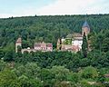
Amorbach Palace | Alsbach Castle | Old castle | Old castle | Auerbach Castle | Bacheburg | Bad König Castle | Beerfurther Schlösschen | Birkenau Castle | Palais Boisserée | Breuberg Castle | Ringwall Bürgstadter Berg | Burgschell | Jagdschlösschen Carlsruhe | Curti lock | Dallau Castle | Darmstadt Castle (Groß-Umstadt) | Dauchstein Castle | Mountain fortress Dilsberg | Dorndiel Castle | Emichsburg | Eberbach Castle | Erbach Castle | Erdwerk Ohrbacher Schanze | Ernsthofen Castle | Eulbach Hunting Lodge | Fechenbach Castle | Frankenberg Castle (Amorbach) | Frankenstein Castle | Freienstein Castle | Freudenberg Castle | Fürstenau Castle | State Park Princely Camp | Fürstenstein Castle | Gammelsbach Hunting Lodge | Ringwall Greinberg | Burgstall Güttersbach | Guttenberg Castle | Grand Ducal Palace (Heidelberg) | Hammer lock | Hardheim Castle | Harfenburg | House to the Giant | Heddersdorf'scher Adelshof | Heidelberg Castle | Heiligenberg Castle | Heppenheim City Palace | Hinterburg | Hirschburg | Hirschhorn Castle | Hochhausen Castle | Hornberg Castle | Hundheim Castle | Jossa Castle | Kirchbrombach Castle | Jagdschloss Krähberg | Kronenburg | Kurmainzer Amtshof | Landsehr Castle | Lichtenberg Castle | Limbach Castle | Lindenfels Castle | Lohrbach Castle | Löwenstein Castle | Lützelbach Castle | Wall hexagon | Max-Wilhelmshöhe hunting lodge | Michelstadt Castle | Mildenburg | Minneburg | Mittelburg | Burgstall Mörlenbach | Palais Morass | Mühlhäuser Schlößchen | Neuburg Castle (Baden) | Nieder-Modau Castle | Upper Heidelberg Castle | Obrigheim Castle | Ohrsberg Castle | Veste Otzberg | Palatinate Castle | Reichenberg Castle | Reichenstein Castle | Riedern moated castle | Rodenstein Castle | Rodenstein Castle | Rohrbach Castle | Rohrbach Castle | Schaafheim Castle | Schanzenköpfle | Schauenburg | Schlierbach Castle | Castle Ober-Beerbach | Schloss-Naus castle | Schneirersbuckel tower hill | Schnellerts Castle | Schönberg Palace | Swallow's Nest | Schwarzach moated castle | Schweinberg Castle | Starkenburg | Stolzeneck Castle | Strahlenburg | Stutz Castle | Amorbach Templar House | Tannenberg Castle | Lower Hardheim Castle | Vorderburg | Wachenburg | Burgstall Waldau | Waldeck Castle | Waldleiningen Castle | Wald-Michelbach Castle | Wambolt's Castle | Hamlet hill | Weinheim Castle | Wiser Castle | Wildenberg Castle | Windeck Castle | Wörth Castle (Wörth am Main) | Zwingenberg Castle

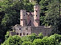
Breuberg Castle near Neustadt

The ruins of Rodenstein Castle near Fränkisch-Crumbach
The swallow's nest , one of the four castles in Neckarsteinach
The castle Zwingenberg am Neckar


Other interesting buildings from different eras should also be mentioned, such as:
the excavated Roman fort near Würzberg , which has been restored as a ruin , the Roman Villa Haselburg near Hummetroth , the old town hall of Michelstadt and the Einhards basilica in Steinbach .
Tourist nature destinations
- Below the 514 m high Felsberg and north of Reichenbach (Lautertal) is the Felsenmeer , a vast collection of very large boulders that was already used as a quarry by the Romans.
- One of the most important stalactite caves in southern Germany was discovered in Eberstadt (Buchen) in 1971 . It is accessible to visitors.
- The crystal nature trail leads around the Katzenbuckel and clearly shows volcanic developments in the Odenwald.
- From Höchst in the Odenwald, the Obrunn Gorge meanders up the valley as a romantic fairy tale path in the direction of Rimhorn with numerous model buildings (palaces, castles and mills).
- When Hessian Hainstadt (to Breuberg) is in Mümlingtal a quarry , that of the Odenwälder climbing friends for climbing has been established; there is a short via ferrata secured with wire ropes . The climbing friends ensure that the paths are maintained. The quarry is located in the catchment area of the Darmstadt-Starkenburg section of the German Alpine Club .
hike
The Odenwald is accessible by a network of hiking trails covering over 10,000 km:
- The Nibelungensteig , a 130-kilometer long- distance hiking trail , leads from Zwingenberg an der Bergstrasse via Lindenfels, Grasellenbach, Mossautal, Beerfelden, Erbach, Amorbach and Miltenberg to Freudenberg am Main .
- The Burgensteig Bergstraße , a 120 kilometer long quality hiking trail, leads from Darmstadt-Eberstadt to Heidelberg along the Bergstraße to many sights.
- The Neckarsteig is a 126.4 kilometer long quality hiking trail that stretches from Heidelberg Castle to the train station in the Staufer town of Bad Wimpfen through the Neckar Valley in the southern Odenwald. Those who hike the Neckarsteig have mastered 140 km in their feet and a total of 3127 meters in altitude. Five castles and 15 castles or castle ruins can be discovered, the Margarethenschlucht can be hiked as a natural monument and the seven medieval cityscapes ( Dilsberg , Neckarsteinach , Hirschhorn , Eberbach , Mosbach , Gundelsheim , Bad Wimpfen) can be visited. Since 2012, the Neckarsteig has replaced the Neckarweg in this area , which runs from the source to the mouth of the Neckar, and is looked after by the Odenwaldklub .
- The Alemannenweg is a 144-kilometer-long quality hiking trail in the northern front of the Odenwald and along the Hessian Bergstrasse . It runs as a great trail of Erbach about Reichelsheim that Felsenmeer in Reichenbach, Bensheim-Auerbach , Frankenstein Castle , Castle Lichtenberg and the Veste Otzberg back to the valley of Mümling to Michelstadt-Steinbach . There are many cultural and historical sights on the Alemannenweg.
- As part of the German Limes hiking trail , the Limes hiking trail of the Swabian Alb Association leads through the Odenwald. From Miltenberg to Osterburken, this path is looked after as the Eastern Limes Path by the Odenwald Club.
- The Odenwald-Madonnen-Weg leads from Tauberbischofsheim through Königheim into the Odenwald near Hardheim and Walldürn , the Neckar valley near Eberbach and Heidelberg to the Rhine plain to Speyer .
Winter sports
Despite the frequent lack of snow, the ski areas of the Odenwald have a few operating days per year. There are plenty of groomed cross-country trails . Also downhill skiing is possible.
- On the Neunkircher Höhe there was a descent and a ski lift (closed since 2010).
- Beerfelden has several slopes and five cross-country trails with a length of up to seven kilometers, which are accessed by a ski lift and floodlights.
- In the Schnorrenbach district of Birkenau there is the possibility of grass skiing in summer , and floodlit skiing and lift operations in winter.
- There is a descent and several circular trails on the Tromm . A ski lift burned down in 2004 and has not been in operation since.
- Below the observation tower on the Katzenbuckel there is a ski jump with plastic mattings. In addition, there are four cross-country trails of different lengths and levels of difficulty in the most snow-sure area of the Odenwald.
- Several kilometers of trails are groomed for cross-country skiing around the villages of Vielbrunn , Würzberg and Rothenberg when the snow conditions are safe.
- On the Hardberg there is the 900 meter long Hardberg slope with a ski lift.
- There are other winter sports opportunities in Michelstadt and Erbach .
language
The Odenwald (in the local dialect: Ourewald ) is the transition area between Rhine Franconian dialects in the west and South Franconian in the east, according to an older breakdown between the Central German and Upper German languages. The Palatinate dialect variants of Rhine-Franconian are called Odenwälderisch , the southern Franconian Odenwäldisch . In the Baden part of the mountains, a sub-group of the Palatinate, the Electoral Palatinate , is common in the north-western Odenwald, the South Hessian .
music
Several songs were written about the Odenwald:
- There is a tree in the Odenwald
- Deep in the Odenwald (Das Odenwaldlied)
- The farmer from the Odenwald
- Something is stirring in the Odenwald
- Girls from the Odenwald ( Gitti & Erica )
- The Schluckspecht from the Odenwald ( Adam and Micky’s )
- By bike through the Odenwald (Adam and Micky's)
- We are the Ourewäller
- Hands off (from the Odenwald) ( Gerd Knebel + Mädness )
- Odenwald ( Egotronic + Johnny Space)
literature
Monographs and anthologies
- Thomas Biller / Achim Wendt: Castles and palaces in the Odenwald. A guide to history and architecture . Schnell & Steiner, Regensburg 2005. ISBN 3-7954-1711-2
- Heinz Bischof: Odenwald . 3rd, revised edition. Goldstadtverlag, Pforzheim 2004. ISBN 3-89550-313-4
- Georg Bungenstab (Hrsg.): Forests in the Odenwald - forest for the Odenwälder. Documents from 150 years of forest history in Eberbach . State Forestry Office Eberbach, Eberbach 1999, 288 pp.
- Otmar A. Geiger: Legendary Odenwald. A guide through the realm of the Nibelungs between Worms and Würzburg . Schimper, Schwetzingen 2000. ISBN 3-87742-152-0
- Walter Hotz: Odenwald and Spessart ( Deutsche Lande - German art ). 2nd edition, Munich / Berlin 1974.
- Keller, Dieter / Keller, Uwe / Türk, Rainer: The Odenwald between heaven and earth. Regional culture publishing house, Ubstadt-Weiher 2003. ISBN 978-3-89735-187-5
- Ludwig Kramarczyk: Odenwald and Bergstrasse . Regio Verlag Glock & Lutz. Sigmaringendorf 1987. ISBN 3-8235-1009-6 .
- Marco Lichtenberger: Saurians from the Odenwald . Jens Seeling Publishing House. Frankfurt 2007. ISBN 3-938973-04-8
- Erwin Nickel : Odenwald. Vorderer Odenwald between Darmstadt and Heidelberg. Bornträger, Berlin / Stuttgart 1985 (collection of geological guides 65).
- Andreas Stieglitz: Hiking in the Odenwald and on the Bergstrasse . From the DuMont active series. DuMont Reiseverlag, Ostfildern 2005. ISBN 3-7701-5015-5 .
- Seipel, Herbert Stephan: Fascination Odenwald. A journey through pictures on the cultural history of the Odenwald. Regional culture publishing house, Ubstadt-Weiher 2004. ISBN 978-3-89735-140-0
- Winfried Wackerfuss (Ed.): On the culture and history of the Odenwald . 2nd unchanged edition 1982. Breuberg-Bund , Breuberg-Neustadt 1982. ISBN 3-922903-01-0
- GC Amstutz, S. Meisl, E. Nickel (ed.): Minerals and rocks in the Odenwald. The opening. Special volume 27, 344 pages, Heidelberg 1975, Minerals and Rocks in the Odenwald , on handle.net (PDF; 20.2 MB)
Periodicals
- Breuberg-Bund (Ed.): Contributions to the exploration of the Odenwald and its peripheral landscapes . Breuberg-Bund, Breuberg-Neustadt 1977 ff.
- Breuberg-Bund (Ed.): The Odenwald . Quarterly magazine of the Breuberg-Bund with articles on the history, folklore, art history and geography of the Odenwald and its peripheral landscapes. Breuberg-Bund, Breuberg-Neustadt 1953 ff.
- District archive of the Odenwaldkreis (ed.): Gelurt . Odenwälder yearbook for culture and history . Odenwaldkreis, Erbach 1994 ff.
- Working group of the history and homeland associations in the Bergstrasse district (ed.): History sheets Bergstrasse district . Laurissa, Lorsch 1971 ff.
- Dieter Wolf : “The Odenwälder” in the “Heil Collection” in Butzbach. Preliminary remark in the reprint of the magazine “Der Odenwälder” by the city of Michelstadt 1998. Ed. Magistrat der Stadt Michelstadt (Michelstadt 1998), pp. XIX-XXII.
Other literature
- Georg Schäfer: The counterfeiters in the Weschnitz valley or the silver bells of Mörlenbach. (Stuttgart 1896)
- Adam Karrillon : Michael Hely . (Berlin 1900/1904)
- Adam Karrillon: The mill at Husterloh . (Berlin 1906)
- Franz Schwalbach: 's Millersch Liss'l vunn Michel'boch. Cheerful folk piece with music and singing in 3 acts: Ourewölla Lieb, de Hondstraich, de Hochzigzugg. (Darmstadt 1908)
- Adam Karrillon: Adam's grandfather. Berlin 1917
- Adolf Schmitthenner : The German heart. 3. Edition. City of Hirschhorn, Hirschhorn 1999. ISBN 3-927409-00-6 (first edition 1927)
- Werner Bergengruen : The book Rodenstein. 3. Edition. Insel, Frankfurt am Main 2002. ISBN 3-458-33493-9 (first edition 1908)
General sources
-
BfN
- Map services
-
Landscape profiles of the Federal Agency for Nature Conservation ( notes ) - by main units:
- 141 ( Sandstone Spessart )
- 144 ( sandstone forest )
- 145 ( Vorderer Odenwald )
References and comments
- ↑ a b c Map services of the Federal Agency for Nature Conservation ( information )
- ^ A b c Emil Meynen , Josef Schmithüsen (editor): Handbook of the natural spatial structure of Germany . Federal Institute for Regional Studies, Remagen / Bad Godesberg 1953–1962 (9 deliveries in 8 books, updated map 1: 1,000,000 with main units 1960).
- ↑ Otto Klausing: Geographical land survey: The natural space units on sheet 151 Darmstadt. Federal Institute for Regional Studies, Bad Godesberg 1967. → Online map (PDF; 4.3 MB)
- ^ Horst Mensching , Günter Wagner : Geographical land survey: The natural space units on sheet 152 Würzburg. Federal Institute for Regional Studies, Bad Godesberg 1963. → Online map (PDF; 5.3 MB)
- ↑ Josef Schmithüsen : Geographical land survey: The natural space units on sheet 161 Karlsruhe. Federal Institute for Regional Studies, Bad Godesberg 1952. → Online map (PDF; 5.1 MB)
- ↑ This numerical value comes from the BfN profile ; The drawing there is recognizable, however, imprecise and crosses the river courses several times.
- ↑ The breath of winter is drawn in on the Karlsruhe and Darmstadt sheets and, after the drawing on the Darmstadt sheet, should continue in small parts on the Würzburg sheet to the immediate west of Walldürn ; there, however, the natural area is not shown or integrated into the foreland of the rear Odenwald .
- ↑ The cat hump is located directly at the seam between 144.6 and 144.5. Strangely enough, its summit area on sheet Karlsruhe is assigned to unit 144.6, which, however, only consists of valleys in the immediate vicinity. It is probably a drawing error.
- ↑ The Hart is at the western seam at 144.60.
- ↑ Map and legend of the natural areas of Hesse (online copy of Die Naturraum Hessens , Otto Klausing 1988) in the Hesse Environmental Atlas of the Hessian State Office for Environment and Geology - the name on the Darmstadt sheet by the same author was Central Rear Odenwald .
- ↑ On sheet Darmstadt the natural area is inadvertently marked as 144.00 ; on sheet Karlsruhe it is the only part of 144.6 in the map section and marked as 144.6 Zertalter Sandstein-Odenwald .
- ↑ The Salzlackenkopf lies at the eastern seam of 144.5.
- ↑ The Hohwald is located directly at the junction between 144.60 and 144.61.
- ↑ The name "Zellerkopf" is shown on the map of the German Empire 1: 200,000 and thus also on the natural space map, sheet Darmstadt; there is often no name on younger maps.
- ↑ The Upper Mudtal is drawn on the Darmstadt sheet and, after it has been drawn there, would have to continue to a small extent on the Würzburg sheet to the northwest of Walldürn ; however, the valley is not shown there.
- ^ Leaf Würzburg: 144.1
- ↑ Journal Wuerzburg: 144.0
- ↑ a b c The division of the crystalline Odenwald into the north-western part, the depression and the part that flows into the sandstone oden forest is not an explicit part of the natural spatial structure, but serves for better orientation
- ↑ In the map from Blatt Darmstadt the Neutsche Ridge is accidentally declared with the number 145.7.
- ↑ a b Topographical hiking map Grasellenbach / Wald-Michelbach , sheet 2, M = 1: 20,000, publisher. Community boards of the communities Grasellenbach Wald and Michelbach, print Geisenheim
- ↑ Tourist map / hiking map of the Bergstrasse-Odenwald-Weinheim-Eberbach Nature Park , sheet 2 (104), M = 1: 50,000, Fietz Verlag, 1978
- ^ Erwin Nickel: Odenwald - Vorderer Odenwald between Darmstadt and Heidelberg . Geological Guides Collection (2nd edition) 65, Borntraeger, Berlin 1985.
- ↑ T. Will, Esther Schmädicke: A first find of retrogressed eclogites in the Odenwald Crystalline Complex, Mid-German Crystalline Rise, Germany: evidence for a so far unrecognized high-pressure metamorphism in the Central Variscides. In: Lithos (2001), No. 59, pp. 109-125.
- ↑ High pressure metamorphosis in the Odenwald , on univis.uni-erlangen.de
- ^ Wolfgang Franke: The mid-European segment of the Variscides: tectono-stratigraphic units, terrane boundaries and plate tectonic evolution. Geol. Soc. London Spec. Publ., 179, pp. 35-61, 2000.
- ↑ R. Altherr u. a .: Plutonism in the Variscan Odenwald (Germany): from subduction to collision . Int. J. Earth Sci. 88, pp. 422-443, 1999.
- ^ AP Wilner u. a .: Tectono-thermal evolution of a part of a Variscan magmatic arc: the Odenwald in the Mid-German Crystalline Rise . Geol.Rdsch. 80, pp. 369-389, 1991.
- ↑ Eckardt Stein u. a .: Geology of the crystalline Odenwald - its magmatic and metamorphic development In: Annual reports and communications Oberrheinischer Geologischer Verein, NF83, pp. 89–111, 2001.
- ↑ M. Okrusch et al. a .: The Odenwald, Germany: Variscan metamorphic evolution and igneous events . Eur. J. Mineral. 12, Beih. 2, pp. 45-89, 2000.
- ↑ H. Kirsch et al. a .: Age of intrusion and rapid cooling of the Frankenstein gabbro (Odenwald, SW-Germany) evidenced by 40Ar / 39Ar and singlezircon 207Pb / 206Pb measurements . Geol. Rundschau 77: pp. 693-711, 1988.
- ^ Carlo Dietl: Structural and Petrologic Aspects of the Emplacement of Granitoid Plutons: Case Studies from the Western Margin of the Joshua Flat-Beer Creek-Pluton (White-Inyo Mountains, California) and the Flasergranitoid Zone (Odenwald, Germany) . Dissertation Heidelberg 2000.
- ↑ Eckardt Stein: Investigations on the genesis of the Flasergranitoid Zone of the central Odenwald - Magmatic and / or tectonic structures. Z. geol. Knowledge 24, pp. 573-583, 1996.
- ↑ AK Schmitt u. a .: The onset and origin of differentiated Rhine Graben volcanism based on U-Pb ages and oxygen isotopic composition of zircon . Europ. J. Mineral. 19, pp. 849-857, 2007.
- ↑ G. Frenzel: The Nepheling Stone Sparagenesis of the Katzenbuckels in the Odenwald . Aufschluss special volume 27, 213-228, Heidelberg 1975.
- ↑ Darmstädter Echo, May 19, 2014, p. 1 ff.
- ↑ The earthquake series in the south of Hesse 2014/2015 on juskis-erdbebennews.de
- ↑ U. Mann u. a .: Influence of oxygen fugacity on mineral compositions in peralkaline melts: The Katzenbuckel volcano, Southwest Germany . Lithos 91, pp. 262-285, 2006.
- ↑ Michael Fettel: Mining history of the Odenwald. In: GC Amstutz u. a. (Ed.): Minerals and rocks in the Odenwald. Der Aufschluss, special volume 27, pp. 267–280, Heidelberg 1975.
- ↑ On mining in the Odenwald see Nickel, Erwin: Odenwald. Vorderer Odenwald between Darmstadt and Heidelberg. Bornträger, Berlin / Stuttgart 1985 (collection of geological guides 65), pp. 56–60; Mössinger, Friedrich: Mines and iron hammers in the Odenwald. Heppenheim 1957 (writings for local history and home care in the Starkenburg area 21/22).
- ^ Fritz-Rudolf Herrmann , Albrecht Jockenhövel: The prehistory of Hesse. Konrad Theiss Verlag, Stuttgart 1990, ISBN 3-8062-0458-6 , p. 186 f.
- ↑ R. Wiermann: Separated and yet united. Archeology in Germany 5/2003 p. 26 f.
- ↑ On the burial see Fritz-Rudolf Herrmann: The villa rustica "Haselburg" near Hummetroth. ² State Office for Monument Preservation Hessen, Wiesbaden 2001. (Archaeological Monuments in Hessen, 55), ISBN 3-89822-055-9 , p. 13.
- ↑ Fritz-Rudolf Herrmann u. Albrecht Jockenhövel: The prehistory of Hesse. Konrad Theiss Verlag Stuttgart, 1990, ISBN 3-8062-0458-6 , p. 332.
- ↑ For a few finds from southern Hesse, see W. Jorns: Neue Bodenurkunden aus Starkenburg. Bärenreiter, Kassel 1953, pp. 90–97.
- ↑ See Egon Schallmayer : The Odenwald Limes . Theiss, Stuttgart 1984, ISBN 3-8062-0328-8
- ↑ E.g. CIL 13, 06511 , CIL 13, 06514 , CIL 13, 06517 , CIL 13, 06518
- ↑ For Haselburg see Dietwulf Baatz : Hummetroth. Rom. Haselburg estate . In: Fritz-Rudolf Herrmann and Dietwulf Baatz (eds.): The Romans in Hessen . Licensed edition of the 1982 edition, Hamburg 1989, ISBN 3-933203-58-9 , pp. 360–362 or Fritz-Rudolf Herrmann: The villa rustica "Haselburg" near Hummetroth . 2nd expanded and supplemented edition. State Office for Monument Preservation Hessen, Wiesbaden 2001. (Archaeological monuments in Hessen, 55), ISBN 3-89822-055-9 ; Friedrich Mössinger still offers a good overview of the numerous smaller sites: The Romans in the Odenwald . Südhessische Post, Heppenheim 1954. (Writings for local studies and home care in the southern Hessian area, 13/14).
- ^ "The territorial development of the Electorate of Trier on the Rhine and Lahn". Historical atlas of Hessen. In: Landesgeschichtliches Informationssystem Hessen (LAGIS).
- ↑ D. Berger: Duden. Geographical names in Germany. Origin and meaning of the names of countries, cities, mountains and waters, 2. revised. Ed., Mannheim a. a. 1999, p. 219.
- ↑ a b Karl Morneweg: Official guide of the Odenwald Club through the Odenwald and the Bergstrasse. Ravenstein, Frankfurt am Main 1926, p. 33.
- ↑ Gero von Wilpert : Specialized Dictionary of Literature (= Kröner's pocket edition . Volume 231). 8th, improved and enlarged edition. Kröner, Stuttgart 2001, ISBN 3-520-23108-5 .
- ^ Walter Albach, Albert Allgöwer: Legends and stories from the Odenwald. Metz, Tübingen 1981
- ↑ Gundula Hubrich-Messow (ed.): Legends and fairy tales from the Odenwald. Husum 1993.
- ↑ A form of weathering was interpreted as the footprint of the victim allegedly killed by the robber; see picture on the left below → Weschnitzpluton
- ↑ Hike on the Neckarsteig - Neckarsteig (Odenwald) , on weitwanderungen.de
- ↑ Odenwald-Madonnen-Radweg ( Memento of the original from April 3, 2018 in the Internet Archive ) Info: The archive link was inserted automatically and has not yet been checked. Please check the original and archive link according to the instructions and then remove this notice. , accessed on December 8, 2016, from radsüden.de
- ↑ Winter sports in the Odenwald , on outback-magazin.de
- ↑ Christina Kolb. In: Darmstädter Echo, Saturday, September 28, 2019, p. 24.
- ↑ Tobias Widmaier: There is a tree in the Odenwald (2012). In: Popular and Traditional Songs. Historical-critical song lexicon of the German Folk Song Archive
- ↑ Theo Mang, Sunhilt Mang (ed.): Der Liederquell . Noetzel, Wilhelmshaven 2007, ISBN 978-3-7959-0850-8 , pp. 419-420 .
- ↑ The farmer from the Odenwald , text and melody on a private website.
- ↑ Something is stirring in the Odenwald ( Memento of the original from September 28, 2007 in the Internet Archive ) Info: The archive link was automatically inserted and not yet checked. Please check the original and archive link according to the instructions and then remove this notice. , Text and melody on the website of the Catholic student association Markomannia Münster im KV .
Web links
- Odenwald Tourismus , official tourism website for the Hessian and Bavarian Odenwald, on odenwald.de
- Touristikgemeinschaft Odenwald , official tourism website for the Odenwald in Baden-Württemberg, at tg-odenwald.de
- Geo-Naturpark Bergstrasse-Odenwald , official homepage of the nature park, at geo-naturpark.de
- Odenwaldklub e. V. , the club's official website, at odenwaldklub.de
- Interest group Odenwald e. V. (IGO), official homepage of the association, on region-odenwald.de
- Odenwaelder Museumsstrasse , on odenwaelder-museumsstrasse.de
- Odenwald - mountains, valleys, castles and palaces , drone video of important sights in the Odenwald