
Cat hump
| Cat hump | ||
|---|---|---|
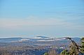
 View to Katzenbuckel with Waldkatzenbach (middle left) |
||
| height | 626.8 m above sea level NHN | |
| location | at Waldkatzenbach ; Neckar-Odenwald-Kreis , Baden-Württemberg ( Germany ) | |
| Mountains | Odenwald | |
| Dominance | 71 km → Kalmit | |
| Notch height | 251 m ↓ Walldürn / Bad Mergentheim | |
| Coordinates | 49 ° 28 '15 " N , 9 ° 2' 28" E | |
|
||
| Type | Chimney filling | |
| rock | basalt | |
| Age of the rock | approx. 60 million years | |
| particularities | - highest mountain in the Odenwald - Katzenbuckel observation tower - Katzenbuckelsee (ex-quarry) - path of crystals (educational trail) |
|

The Katzenbuckel is an extinct volcano and at 626.8 m above sea level. NHN the highest mountain in the Odenwald . It is located near Waldkatzenbach in the Neckar-Odenwald district in Baden-Württemberg .
The Katzenbuckel observation tower is on the mountain . It is the location of the Katzenbuckelsee (ex-quarry) and of the way of the crystals (nature trail).
Geographical location
The Katzenbuckel rises in the Neckartal-Odenwald Nature Park in the district of Waldbrunn . Its summit is 3 km west of its core town and 4 km east-northeast of the core town of Eberbach am Neckar . Waldkatzenbach is at the south-eastern foot of the slope.
geology
The Katzenbuckel volcano towers over the red sandstone plateau of the Odenwald today . Its vent was about 1000 meters in diameter. At the time of an eruption around 60 million years ago, a package of sedimentary rocks with a thickness of over 600 meters up to the layers of the Jura was still lying above the present land surface . These were removed over the course of millions of years (an average of 1 mm in 100 years), exposing the hard basalt rock of the volcano, the foidite sanidin - nephelinite . The excavated at the next summit Michelberg sodium - Shonkinit created by afterflow of magmas in the much larger sanidine nephelinite-Magmenkörper intruded .
Tuffs and small volcanic bombs prove that the Katzenbuckel volcano erupted, presumably explosively as a result of a water vapor explosion caused by groundwater-magma contact in the subsurface ( maar volcanism), at least this is indicated by tuffs with secondary rock inclusions. Traces of a collapse funnel or a caldera have not yet been found. The development of volcanism at Katzenbuckel has to be clarified more precisely by geological investigations based on the current research situation; the last geoscientific research projects were undertaken in the 1970s and 1980s.
The volcanic rock was quarried as gravel in two quarries . In the quarry on Gaffstein a variety of the Katzenbuckel main rock sanidine nephelinite was obtained, in the quarry on Michelsberg (second summit of the Katzenbuckels) sodium shonkinite; the Michelsbergkuppe was removed. After a blast in 1970, groundwater came to light here and filled the lower levels of the quarry; this created the Katzenbuckelsee.
At the Katzenbuckel there are gang rocks with an abundance of minerals, which are hardly to be found today, since after the end of the quarry there are no more fresh outcrops. Natrolite and apatite , for example, were previously identified . A high content of magnetite in some places, especially on the summit rock, distracts compass needles from the magnetic north direction.
The cat hump and its rocks have been the subject of numerous scientific studies. The dissertation on "Nephelinit vom Katzenbuckel" by H. Rosenbusch was published in the 19th century. Further to be mentioned are the investigations by W. Freudenberg from 1906, H. Nieland 1931, or G. Frenzel 1955 and 1975. In 1982, Volker Schweizer published a geological guide to the southern Odenwald in collaboration with Reinhart Kraatz , in which, among others the geology of the Katzenbuckels and its outcrops are described.
Origin of name

There are various unsecured explanations for the origin of the word "Katzenbuckel". According to one, the shape of the mountain is said to have reminded the residents of the hunched back of a cat. Others derive the mountain name from the tribal name of the Chatten , who once had their main settlement area in northern and central Hesse; he also lives on in the name of the federal state of Hesse , only three kilometers away .
climate
The Katzenbuckel and its surroundings are noticeably cooler than other parts of the Odenwald, which has given its plateaus the popular name "Winter Breath".
Usually the first snow falls from the beginning of November. For the entire winter there was usually around 30 centimeters of snow on the Katzenbuckel, sometimes up to 70 centimeters. It often only thawed at the end of April, which is why the cross-country ski trails and the ski jump (Katzenbuckelschanze) on Katzenbuckel used to be considered particularly snow reliable. Since the snow did not appear more and more recently, the Katzenbuckel-Schanze was converted into a plastic covered hill by the operator, the Katzenbuckel-Eberbach Ski Association. The inrun now has a ceramic track so that you can jump all year round. In order to promote the next generation, a so-called mini jump and a small jump have been built in recent years.
Way of the Crystals
A geological and mineralogical nature trail - the "Path of the Crystals" - explains the history of the origins of the Katzenbuckels. It begins in the former quarry on Katzenbuckelsee and ends on the mountain top by the observation tower. The 1.5 km long, signposted path can be walked on in a good hour.
Katzenbuckel observation tower
On the top of the Katzenbuckel stands the 18 m high Katzenbuckel observation tower , which was built from sandstone in 1820 . It offers a panoramic view of the wooded peaks and ridges of the Odenwald and the neighboring low mountain ranges. In favorable weather conditions, distant views are even possible as far as Donnersberg (83 km) and into the Taunus (> 90 km); When the visibility is optimal, even the Kreuzberg in the Rhön, 120 km away, is visible.

additional
18th century German emigrants from the area around Eberbach gave a survey in their new home Ephrata in Pennsylvania the name "Katzebuckel". The term is still in use among Pennsylvania Germans . The “Cat's Back Road” leads over the summit, in PA German “Cat Boucle Weeg”, German about Katzenbuckelstrasse .
gallery
The Katzenbuckel seen from Bergfeld (Mosbach) (center)

Ski jump at Katzenbuckel

Winter sports on the Katzenbuckel

The Katzenbuckelsee

Katzenbuckel observation tower


Individual evidence
- ↑ a b Map services of the Federal Agency for Nature Conservation ( information )
- ↑ Dominances and celebrities ( memento of the original from October 19, 2014 in the Internet Archive ) Info: The archive link was inserted automatically and has not yet been checked. Please check the original and archive link according to the instructions and then remove this notice. , on highrisepages.de
- ^ A b Volker Schweizer, with the collaboration of Reinhart Kraatz: Kraichgau and southern Odenwald. Geological Guides Collection , Volume 72, 203 pages, Verlag Gebrüder Bornträger, 1970. ISBN 978-3-443-15031-0
- ^ V. Betz: About mineral finds from Katzenbuckel / Odenwald. Aufschluss, 24, Heidelberg 1973
- ^ H. Rosenbusch: Der Nephelinit vom Katzenbuckel , dissertation University of Freiburg, 1869, on books.google.de
- ^ W. Freudenberg: Geology and petrography of the Katzenbuckels in the Odenwald. Communications from the Baden Geological State Institute, Vol. 5, pp. 185–344, 1906
- ^ H. Nieland: Contributions to the mineralogy and petrography of the Katzenbuckels in the Odenwald. New Yearbook for Mineralogy, Geology and Paleontology, Supplements, Vol. A 63, Stuttgart 1931
- ↑ G. Frenzel: Introduction to the geology and petrography of the Katzenbuckels in the Odenwald. Aufschluss, special volume 2, Roßdorf 1955
- ↑ G. Frenzel: The Nepheling Stone Sparagenesis of the Katzenbuckels in the Odenwald. Aufschluss, special volume 27 (Odenwald), Heidelberg 1975
- ↑ Climate of the Odenwald ( Memento from January 4, 2015 in the web archive archive.today ), in Theme Park Environment → Buntsandstein-Odenwald: Climate , on themenpark-umwelt.baden-wuerttemberg.de
- ↑ Der Katzenbuckel ( Memento from May 12, 2016 in the web archive archive.today ), on naturpark-neckartal-odenwald.de
- ↑ New training center for ski jumpers on Katzenbuckel , from July 27, 2008, on katzenpfad.de
- ↑ Lookout tower on the Katzenbuckel , in: My vacation in Germany , on auf-reisen.de
- ↑ View from Katzenbuckel to the north , graphic panorama, looking north
Web links
- The Katzenbuckel - witness mountain of volcanism , in: Theme park environment , on themenpark-umwelt.baden-wuerttemberg.de
- Katzenbuckel - old tertiary volcanic deposits ( memento from July 6, 2013 in the Internet Archive ), on archive.org, excursion report from the Institute for Geography, University of Gießen, from uni-giessen.de