
Kalmit
| Kalmit
(Great Kalmit)
|
||
|---|---|---|
 The Kalmit from the east |
||
| height | 672.6 m above sea level NHN | |
| location | at Maikammer ; Palatinate Forest , Rhineland-Palatinate ( Germany ) | |
| Mountains | Haardt | |
| Dominance | 36 km → Donnersberg (686.5 m) | |
| Notch height | 388 m ↓ 2 km southeast of Wintersbourg or 1 km southwest of Zilling (285 m) | |
| Coordinates | 49 ° 19 '9 " N , 8 ° 4' 58" E | |
|
||
| rock | Rocks of the lower and middle red sandstone | |
| Age of the rock | 251 to 243 million years | |
| particularities | highest mountain in the Palatinate Forest with
|
|

The Kalmit , more rarely also called Great Kalmit , at Maikammer in the Rhineland-Palatinate district of Südliche Weinstrasse is 672.6 m above sea level. NHN the highest mountain in the Palatinate Forest and after the Donnersberg the second highest peak in the Palatinate region . The mountain lies in the Haardt , the eastern edge of the Palatinate Forest. There are different theories about the origin of the name, which allow an interpretation as a bare mountain or a high mountain or summit mountain .
On the mountain there is an observation tower with a relay radio station, a weather station and a remote view measuring station, the Kalmithaus and the Kalmit transmitter . On the southwest spur Hüttenberg the natural monument is Felsenmeer Hüttenberg .
Surname
The origin of the name Kalmit is not certain, there are various attempts at interpretation. One possible variant goes back to the Latin calvus mons 'bald mountain' . It could also, similar to the family name Kallmund or Calmund , a composition of dt. Bald and lat. Mons present. A purely Germanic origin in the combination of kahl with munti for 'protection system' or 'mountain / hill with protection system' is also conceivable . Another possibility is the origin of the idg. Kel / kol or qel / qol for 'high, rise' in connection with mons , moon or other variants for 'mountain'; this would allow an interpretation as 'high mountain' or 'high mountain' or 'summit mountain'. Examples of geographic names that may have been created similarly include: a. Calmont , Külmitz , Kollmitzberg , Kalsmunt , Kallmuth , Kallmünz or Kellmünz are listed.
geography
location
The Kalmit is located in the Palatinate Forest Nature Park and also in the cross-border Palatinate Forest-Vosges du Nord biosphere reserve . Its summit rises 3.8 km west-north-west of the center of the wine-growing community of Maikammer and 5.5 km south-west of the center of Neustadt an der Weinstrasse (both as the crow flies ). The mountain belongs to the municipal forest of Maikammer.
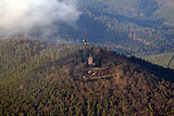
View of the Kalmit from the plane (approximately in the north-west)

Kalmitmassiv with (from left) Breitenberg , Kalmit, Kanzel and Wetterkreuzberg

Kalmit with pigeon head in the foreground (view from the Hohen Loog )

Wetterkreuzberg with Maria-Schutz-Chapel


Foothills and Little Kalmit
Several foothills and neighboring mountains or peaks are grouped around the Kalmit, such as the dwarf mountain ( 589.3 m ) in the north, which leads to the Hohen Loog ( 618.7 m ) , the Taubenkopf ( 603.8 m ) in the northeast, the pulpit ( 531 , 7 m ) and the Wetterkreuzberg ( 400.7 m ) in the southeast, the Stotz ( 603.2 m ) and the Breitenberg ( 545.2 m ) in the south and the Hüttenberg ( 620.1 m ) in the southwest.
About 15 km south-southwest of the (Great) Kalmit, between Ilbesheim and Arzheim, lies the 270.5 m high Kleine Kalmit . It is part of the foothills of the Palatinate Forest and about 4 km (as the crow flies) from the edge of the mountains.
Waters
The approximately 5 km long Alsterweiler Bach rises in a cut in the eastern slope of the Kalmit, 1 km southeast of the summit. It flows to Maikammer and flows east of the local community from the left into the Kropsbach , which eventually becomes the right tributary of the Speyerbach . The Kropsbach has its source southwest of the Kalmit massif and on its course, which leads past the Kalmit to the south, absorbs the water from the Wolsel spring there, which flows into it from the left via a 500 m long stream. The Kaltenbrunnertalbach rises to the northwest of the Kalmit and passes the massif in the north and reaches the Speyerbach from the right in Neustadt. To the northeast is the source of the Wooggraben, which flows to the east and flows into the Schlittgraben from the right in Lachen-Speyerdorf , which in turn feeds its water via Nellenbach and Kropsbach to the Speyerbach.
Natural allocation
The Kalmit belongs to the Palatinate Forest natural area, which is classified as a 3rd order Greater Region in the systematics of the handbook of the natural spatial structure of Germany published by Emil Meynen and Josef Schmithüsen and its subsequent publications . According to the internal division of the natural area , the Kalmit belongs to the Middle Palatinate Forest and the Haardt mountain range, which separates the Palatinate Forest from the Upper Rhine Plain .
In the hierarchy of natural areas, the Kalmit is thus in the following nesting:
- Greater region 1st order: Layer level land on both sides of the Upper Rhine Rift
- Greater region 2nd order: Palatinate-Saarland layer level land
- Greater region 3rd order: Palatinate Forest
- 4th order region (main unit): Middle Palatinate Forest
- 5th order region: Haardt
Mountain height
The Kalmit is 672.6 m above sea level. NHN high. Their height is also given as 673.3 m .
flora

Like almost all of the rest of the Palatinate Forest, the Kalmit - the following figures come from the Haardt Forestry Office, which is based in Landau and is responsible for the forests around the Kalmit, Kesselberg ( 662 m ) and Weinbiet ( 554 m ) mountains - is predominantly from Overgrown mixed forest, the composition of which is similar everywhere in the forestry department. The conifer population is dominated by pine (around 10,300 ha), spruce (around 1,600 ha) and Douglas fir (around 1,700 ha) follow at a greater distance. In the deciduous trees, beeches (around 7,000 ha) and oaks (around 2,600 ha) predominate .
Protected areas
Part of the fauna-flora-habitat area of the Palatinate Forest Biosphere Reserve (FFH no. 6812-301; 359.97 km²) lies on the Kalmit southwestern foothills of Hüttenberg . Apart from its northwest flank, parts of the Haardtrand bird sanctuary are located on the mountain (VSG no. 6514-401; 147.28 km²).
summit
Observation tower and transmission tower


After the observation tower built on the summit in 1868 collapsed, the main association of the Palatinate Forest Association built a new, 21 m high observation tower in 1928/29 . From the beginning it was equipped with living quarters, electric light and running water. From this tower one had a comprehensive panoramic view, not only of the entire Palatinate Forest and the Vosges to the south , but also to the mountain ranges of the Hunsrück , Taunus , Odenwald and Black Forest on a clear day . In the opinion of contemporaries at the time, the Kalmit was therefore “the most beautiful panoramic mountain in the Palatinate”.
In the meantime, there are various measuring and radio systems in and on the tower, so that it was initially temporarily and completely closed to the public in the last few decades. A relay radio station, a weather station and a far-sight measuring station are operated.
On the mountain top, next to the observation tower, there is the free-standing steel frame transmission tower of the Kalmit transmitter, which serves as a telecommunications system and radio transmitter. It broadcasts the FM radio programs RPR1 103.6 MHz and BigFM 106.7 MHz.
Kalmithaus

The Kalmithaus was built in 1908 as a managed hiking hut Ludwigshafener Hütte by the PWV local group Ludwigshafen and expanded in 1934. After the Second World War, the hut was initially used for military purposes by the French occupying forces . In 1953, after lengthy negotiations, it was released again and put into operation again in 1955. As the house showed major damage, it was replaced by a completely new, more modern building, the Kalmithaus, in 1957. On November 13, 1981, a gas explosion occurred in the house, which completely destroyed the front part. The inauguration of the Kalmithaus in its present form took place on June 12, 1983. In the decades that followed, further modernizations were carried out, such as the construction of a new sewage treatment plant and the conversion to biological wastewater treatment. In addition, the connection to the water supply of the Maikammer community was established.
The Kalmithaus is the highest hut in the Palatinate Forest and is open at different times of the year. Since 2012 it has no longer been run by association members on a voluntary basis, but by permanent staff; the menu is based on regional Palatinate cuisine . Overnight stays are not possible.
Opportunities for viewing

From the patio on the terrace of the Kalmithaus, the summit of the Kalmit offers a good view to the east into the Upper Rhine Plain , some 500 m below . a. with the local communities close to the mountains Maikammer ( 170 m altitude) and St. Martin ( 225 m ). On the level, the view extends to the cities of Ludwigshafen ( 95 m ) and Mannheim ( 97 m ) as well as Speyer ( 103 m ) and Philippsburg ( 100 m ).
In the far area, the south-western part of the Odenwald near Heidelberg with the Königsstuhl ( 570.3 m ) and further to the south-east the mountain ranges of the northern Black Forest can be seen. On a clear day you can see for example the Badener Höhe ( 1002.2 m ), the northernmost thousand in the Black Forest, and the Hornisgrinde , at 1164.4 m the highest mountain in the northern Black Forest.
The line of sight of the castle in Schwetzingen ( 101 m ), 36 km away, is aligned exactly to the Kalmit towards the west-southwest. In the north-northwest, the highest peak in the Palatinate can be seen at the same distance, the 686.5 m high Donnersberg in the North Palatinate Uplands .
Felsenmeer Hüttenberg

The Felsenmeer Hüttenberg is located on the Kalmit-Vorberg Hüttenberg . The area is littered with large boulders that originate from the so-called Karlstalschichten of the Middle Buntsandstein . They were created during various cold periods , when the previously closed rock layer was broken up into individual rubble by frost blasting .
Sport and hiking
General
The steeply rising Kalmithöhenstraße is not only used for general traffic, but there will also sport events such as mountain running competitions and cycling instead. Since May 2008, a so-called Stoppomat , an automatic time recording system, has been available for cyclists, runners and skaters ; the starting device is at the western exit of Maikammer at an altitude of about 170 m , the target device at the Kalmit car park a little below the summit, 5.75 km away from the starting device.
Sporting events
- The Kalmit Folding Bike Cup has been held since 1992 , in which only folding bikes without gears are permitted. The competition takes place every year on the first Saturday in September.
- The Kalmit Mountain Run, which has been held since 1992 and takes place every November, is the seventh and last run of the year for the Palatinate Mountain Run Cup in the Palatinate mountain run series . More than 600 runners regularly take part. The route is 8100 m long and accumulates over 505 meters in altitude; at 2800 m and 6200 m there are intermediate scores.
- Every year in June since 2006, the cycle route of the Mußbach Triathlon for the BASF Triathlon Cup Rhein-Neckar leads from Neustadt up to Kalmit and then down to Maikammer.
- On August 23 and 24, 2009, the endurance athlete Christoph Fuhrbach covered 488 km on Kalmithöhenstraße within 24 hours and climbed 17,615 meters in altitude. He drove up and down the almost 6 km long route between Maikammer and the Kalmit parking lot 42 times; on the 43rd ascent, at the end of the 24 hours, he reached the 400-meter height sign. Fuhrbach exceeded the previously known German best performance by Rainer Klaus , who had achieved 15,458 meters in altitude in 1996.
Hiking trails
The Kalmit is a stage destination for some circular and long-distance hiking trails in the Palatinate Forest :
- The Pfälzer Weinsteig Prädikatsweg, which was opened in autumn 2010 and certified in 2011 according to the quality criteria of the German Hiking Association , also touches the Kalmit region on its fourth stage. It runs from Neustadt over the Nollenkopf , the Hambacher Schloss and the Hohe Loog to the Hahnenschritt mountain saddle and from there reaches the Kalmit summit after just under a kilometer. The hiking trail then crosses the sea of rocks on the Hüttenberg and, after a long descent, leads to the wine-growing community of St. Martin.
- A hike along the way marked Roter Punkt from Neustadt main station via Hohe Loog, alternatively from St. Martin via Wolselquelle and Felsenmeer, takes about one and a half to two hours on both route variants, depending on the walking pace, and overcomes a difference in altitude of around 500 m .
- From Maikammer the hiking trail with the white-green marking leads to the Kalmit.
Transport links

You can reach the Kalmit by private vehicle via the Autobahn 65 ( Ludwigshafen am Rhein - Karlsruhe ) and its junction 14 Edenkoben . From there it is about 3 km to Maikammer on federal road 38 . This is where the Kalmithöhenstraße begins as part of Landesstraße 515 and with the signposted destination “Kalmit” . After a 6 km drive, it crosses the Kalmit highlands, roughly from east to west. At a height of around 600 m , a 600 m long cul-de-sac branches off to the left from the state road. It runs counterclockwise north around the summit region to the Kalmit hikers' car park , which is located west-northwest of the mountain summit on a sub-plateau at a height of about 645 m . From there, the summit can be reached after a walk of almost 500 m.
The public transport offers from May to October on Sundays and public holidays, the hiking bus Kalmitexpress from the main train station Neustadt to Kalmit. The journey time is around 35 minutes, the buses are tailored to the timetable of the local trains and S-Bahn. Special tickets, such as the Rhineland-Palatinate Ticket, are also recognized on the bus .
Web links
- Kalmit. The Kalmithöhenstrasse. (No longer available online.) In: maikammer-erlebnisland.de. Association of Southern Wine Road Maikammer e. V., archived from the original on November 28, 2018 .
- Visibility in the Palatinate Forest. In: hdn-pfalz.de. Ministry for the Environment, Energy, Food and Forests, Rhineland-Palatinate
- Map of Kalmit and the surrounding area on: Map service of the landscape information system of the Rhineland-Palatinate nature conservation administration (LANIS map) ( notes )
Notes and individual references
- ↑ a b c d Map services of the Federal Agency for Nature Conservation ( information )
- ^ Institut Géographique National (ed.): Carte Topographique 1: 25,000, Saverne, Sarrebourg . Published by the Institut Géographique National, Paris 1999.
- ↑ Jürgen Udolph : Dortmund - New to an old name. In: Günther Högl, Thomas Schilp (Hrsg.): Contributions to the history of Dortmund and the county of Mark. Volume 100/101, Historical Association for Dortmund and the Grafschaft Mark e. V., Dortmund 2009/2010, pp. 30–32 ( mgh-bibliothek.de [PDF; 1.7 MB]).
- ^ Federal Institute for Regional Studies: Geographical Land Survey. The natural space units in single sheets 1: 200,000 . Bad Godesberg 1952–1994. → Online maps , sheet 160: Landau i. d. Pfalz (Adalbert Pemöller, 1969; 47 p.).
- ↑ Helmut Beeger u. a .: The landscapes of Rheinhessen-Pfalz - naming and spatial delimitation. In: Reports on German regional studies. Volume 63, Issue 2, Trier 1989, pp. 327-359.
- ↑ Map service of the landscape information system of the Rhineland-Palatinate nature conservation administration (LANIS map) ( notes )
- ↑ Kalmit. The Kalmithöhenstrasse. (No longer available online.) In: maikammer-erlebnisland.de. Association of Southern Wine Road Maikammer e. V., archived from the original on November 28, 2018 ; accessed on September 17, 2019 .
- ↑ The forest in our forestry office. Ministry of the Environment, Agriculture, Food, Viticulture and Forestry, accessed December 31, 2014 .
- ↑ a b Our forest in numbers: Tree species distribution. Ministry of the Environment, Agriculture, Food, Viticulture and Forestry, accessed December 31, 2014 .
- ↑ Emil Heuser: New Palatinate leader. Waldkirch Verlag Ludwigshafen / Rh. 14th edition 1979 (2nd edition 1876), pp. 238-239.
- ^ Adolf Hanle: Meyers Naturführer, Palatinate Forest and Wine Route. Bibliographisches Institut, Mannheim 1990, pp. 65-66.
- ↑ History & information , on kalmithaus.de. Retrieved January 29, 2014.
- ↑ Heinz Wittner: Big Palatinate leader. German hiking publisher Dr. Mair & Schnabel & Co. Stuttgart 1981, p. 129.
- ↑ a b Das Kalmithaus (official website). Retrieved January 29, 2014.
- ↑ Automatic stop watch for summiteers . In: The Rhine Palatinate . Ludwigshafen April 30, 2008.
- ↑ Kalmit folding bike Cup. Organizer website, accessed January 21, 2013 .
- ↑ Mußbach Triathlon. TV Mußbach 1860, accessed on January 21, 2013 .
- ↑ Fuhrbach manages 17,615 meters in altitude . In: The Rhine Palatinate . Ludwigshafen August 25, 2009.
- ↑ Hiking Compass Germany: Palatinate Weinsteig. Retrieved January 25, 2014.
- ↑ Tobias Kauf: Pfälzer Weinsteig, Complete Route ( Memento from July 23, 2014 in the Internet Archive ). In: outdooractive.com, November 10, 2010, accessed January 25, 2014.
- ^ Kalmit Express (line 503) ( Memento from April 2, 2015 in the Internet Archive ). Palatinabus, VRN - Rhein-Neckar Transport Association. Retrieved March 15, 2015.
- ↑ Bus route network map Neustadt Regionalverkehr ( Memento from April 2, 2015 in the Internet Archive ). (PDF; 63 kB) Palatinabus, VRN - Rhein-Neckar transport association. Retrieved March 15, 2015.