Nollenkopf (Haardt)
| Nollenkopf | ||
|---|---|---|
|
Nollenkopf (center), Neustadter Afrikaviertel (front), Hohe Loog (right back), Hambacher Schloss (left back) |
||
| height | 490 m above sea level NHN | |
| location | near Neustadt an der Weinstrasse , Rhineland-Palatinate ( Germany ) | |
| Mountains | Haardt ( Palatinate Forest ) | |
| Coordinates | 49 ° 20 ′ 40 " N , 8 ° 6 ′ 50" E | |
|
|
||
| rock | Red sandstone | |
| particularities | Inscription stones on the dome | |
The Nollenkopf , also Nollen , is 490.3 m above sea level. NHN high mountain in the Haardt , a low mountain range on the eastern edge of the Palatinate Forest to the Upper Rhine Plain . It is located on the forest boundary of the urban district Neustadt an der Weinstrasse in Rhineland-Palatinate .
geography
location
The Nollenkopf rises in the Palatinate Forest-Vosges du Nord Biosphere Reserve and Palatinate Forest Nature Park . Its peak is located 1.8 km southwest of the standing in the Neustadter Old Town St. Mary's Church and 1.6 km northwest of the district in Neustadter Hambach standing St. James Church on the west shoulder of the grave breach , of about 65 million years led to the subsidence of the Upper Rhine Plain.
The Africa quarter of Neustadt, whose streets are named after Africa researchers, extends on the north-northeast slope of the mountain . In the Neustadter Valley to the north, the Speyerbach flows from west to east and enters the Upper Rhine Plain from the low mountain range. A saddle ( 464.2 m ) with the Speierheld refuge leads to the Hohen Loog ( 618.7 m ), which belongs to the Kalmit massif ( 672.6 m ), to the south-southwest . To the east the landscape drops over the Hohe Felsen to the Nollensattel ( 320.4 m ) and to the southeast to the Häuselberg ( 319.8 m ) - two spurs in front of the Nollenkopf on the eastern edge of the Haardt.
Apart from residential streets that lead in the Neustadter Afrikaviertel and in Hambach down to the slopes of the Nollenkopf, the mountain is only accessible through forest and hiking trails.
Natural allocation
The Nollenkopf belongs to the Palatinate Forest natural area, which is classified as a 3rd order Greater Region in the systematics of the handbook on the natural structure of Germany published by Emil Meynen and Josef Schmithüsen and its subsequent publications . If one considers the internal structure of the natural area , the Nollenkopf belongs to the Middle Palatinate Forest and here to the Haardt mountain range, which separates the Palatinate Forest from the Upper Rhine Plain .
In summary, the natural spatial allocation of the Nollenkopf follows the following system:
- Greater region 1st order: Layer level land on both sides of the Upper Rhine Rift
- Greater region 2nd order: Palatinate-Saarland layer level land
- Greater region 3rd order: Palatinate Forest
- 4th order region (main unit): Middle Palatinate Forest
- 5th order region: Haardt
Protected areas
The Haardtrand - Am Häuselberg nature reserve is located on the eastern slope of the wooded Nollenkopf to the south-east of the wooded Nollenkopf ( CDDA no. 163427; designated in 1989; 7.64 hectares in size). Part of the Haardtrand bird sanctuary is also located there (VSG no. 6514-401; 147.28 km² ).
Attractions
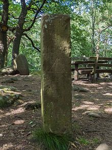
On the Nollenkopf there are three memorial and inscription stones , which were first attested in 1696 and are under monument protection .
One of the three stones was created during the War of the Palatinate Succession (1689–1697). Batteries and entrenchments were built on the mountain from September to December 1696 when the French army withdrew. The six-line inscription on a memorial stone reminds of this:
|
Original French text : |
German translation: |
There is also a Bavarian language level from 1838. In a topographical survey of the Palatinate area, which then belonged to the Kingdom of Bavaria, by officers of the Royal Bavarian General Staff from 1836 to 1837, the height is given as 168.4 Bavarian rods (a Bavarian rod = 2.9186 m) - based on the Adriatic level near Venice. This results in a total height of 491.49 m. In today's topographic maps the height is given as 490.3 m .
Another memorial stone is "The Stone of Wise Contentment".
On the eastern slope of the mountain is the Waldmannsburg , which is designated as a cultural monument and belongs to the district of the Neustadt core town.
Web links
Individual evidence
- ↑ a b c Map service of the landscape information system of the Rhineland-Palatinate nature conservation administration (LANIS map) ( notes )
- ↑ Adalbert Pemöller: Geographical land survey: The natural spatial units on sheet 160 Landau i. d. Palatinate. Federal Institute for Regional Studies, Bad Godesberg 1969. → Online map (PDF; 4.2 MB)
- ↑ Helmut Beeger u. a .: The landscapes of Rheinhessen-Pfalz - naming and spatial delimitation. In: Reports on German regional studies , Volume 63, Issue 2, Trier 1989, pp. 327–359.
- ↑ Map services of the Federal Agency for Nature Conservation ( information )
- ↑ Michael Huyer (Editor): cultural monuments in Rhineland-Palatinate. Monument topography Federal Republic of Germany . tape 19 .2: City of Neustadt an der Weinstrasse. Districts Diedesfeld, Duttweiler, Geinsheim, Gimmeldingen, Haardt, Hambach, Königsbach, Lachen-Speyerdorf, Mußbach . Verlag Werner, Worms 2008, ISBN 3-88462-265-X .
- ^ A b General Directorate for Cultural Heritage Rhineland-Palatinate (ed.): Informational directory of cultural monuments. District-free city of Neustadt an der Weinstrasse. (PDF; 1.4 MB) 2010, accessed on November 14, 2012 .


