
Külmitz
| Külmitz | ||
|---|---|---|
 The Külmitz as seen from the Great Kordigast Plateau (south view) |
||
| height | 437.8 m above sea level NHN | |
| location | District of Lichtenfels , Upper Franconia , Bavaria , Germany | |
| Mountains | Altenkunstadt-Buchauer Albvorland ( Upper Main Hügelland / Franconian Alb ) | |
| Dominance | 2.78 km → Great Kordigast | |
| Notch height | 132.8 m ↓ Valley of the Gray Monks | |
| Coordinates | 50 ° 7 '38 " N , 11 ° 12' 44" E | |
|
||
| Type | Zeugenberg | |
| rock | Iron sandstone with layers of brown and black Jurassic rock underneath | |
| Development | several dirt roads to the summit | |
| Normal way | From Altenkunstadt , Strössendorf and Pfaffendorf in about 30 minutes each. | |
| particularities | Remains of an early medieval section fortification | |

The Külmitz is 437.8 m above sea level. NHN high Zeugenberg in the Altenkunstadt-Buchauer Albvorland near Altenkunstadt .
Location and description
The Külmitz is a predominantly gently rising, 600 meter long mountain ridge running in an east-west direction. on the western outskirts of Altenkunstadt . In the southwest area there is a small plateau, the highest point of the mountain. The mountain rises steepest on the southwest flank there. The difference in altitude between the summit plateau and the village of Pfaffendorf at the foot is 138.2 meters after comparing the two official altitude figures. Side peaks of the Külmitz are the Steinbühl in the east with 375.3 m above sea level. NHN , the Goldberg in the north with 321 m above sea level. NHN and the Rangen in the east at 373 m above sea level. NHN .
There are several villages around the Külmitz; in the south Pfaff village , west Spiesberg , northwest Zeublitz and north Strössendorf . The dominance to the next higher mountain, the Großer Kordigast , is 2.780 kilometers, the Schartenhöhe to the valley of the gray monks near Pfaffendorf 132.8 meters.
Settlement history
The name Külmitz is of Slavic origin. On the east side of the summit there are remains of an early medieval section fortification , probably a refuge with the character of a hill fort . There are three consecutive section walls, each with a ditch between them. The wall-ditch system extends over a width of around 35 and a length of around 70 meters. The height difference between the crest of the wall and the bottom of the trench is a maximum of 1.8 meters for the outer, one meter for the middle and 1.6 meters for the inner fortifications. The entire interior of the fastening system was 220 meters long and 80 meters wide. a goal could not be made out anywhere.
Such a fortification was not necessary on the south, west and north sides of the mountain, as the Külmitz slopes steeply on these sides, or if there was an artificial fortification there, it cannot be proven. In the east, the mountain falls the flattest, so that fortification was necessary there. In the southern area, the system has recently been damaged, as well as in the north, where the ramparts were affected by sand pits . The resulting profile view of the defense system is best seen in the sand pits in the north.
photos

Forest path in the summit area of Külmitz with a sign pointing to the Keltenwall , which can be recognized as bumps
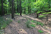
Wall-ditch remnants running parallel to the summit area of Külmitz

Wall-ditch remnants running parallel to the summit area of Külmitz
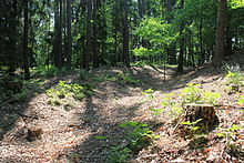
Wall-ditch remnants running parallel to the summit area of Külmitz

View of the former sandstone quarry in the summit area of Külmitz


literature
- Björn-Uwe Abels: Guide to archaeological monuments in Bavaria, Franconia. (= Volume 2: Archaeological Guide Upper Franconia. ) Konrad Theiss Verlag, Stuttgart 1986, ISBN 3-8062-0373-3 , pp. 109–110.
- Ingrid Burger-Segl: Archaeological forays in Meranierland am Obermain , District of Upper Franconia, Bayreuth 2006, ISBN 3-9804971-7-8 , pp. 119–121.
- Josef Motschmann: Altenkunstadt - home between Kordigast and Main . Altenkunstadt community, Altenkunstadt 2006.
Web links
Individual evidence
- ↑ a b c d Külmitz, Pfaffendorf and Kordigast in the Bayern Viewer ( memento of the original from May 19, 2015 in the Internet Archive ) Info: The archive link has been inserted automatically and has not yet been checked. Please check the original and archive link according to the instructions and then remove this notice. , geodaten.bayern.de, accessed on May 17, 2012
- ↑ a b c d e f g h i j Abels (1986), pp. 109-110
- ↑ Motschmann 2006, p. 12
- ↑ a b c d e Motschmann 2006, p. 18
- ↑ entry to Külmitzberg in the private database "All Castles".
Locks: Schloss Buch | Ebneth Castle | Giechkröttendorf Castle | Hochstadt moated castle | Kleinziegenfeld Castle | Old Castle (Lichtenfels) | Lichtenfels City Palace | Maineck Castle | Redwitz Castle | Schney Castle | Strössendorf Castle | Trieb Castle (Nassanger Castle) | Unterlangenstadt Castle | Wildenroth Castle
Castles and ruins: Ansberg Castle (dismissed) | Niesten Castle (exited)
Moths (all gone): Hahnhof Tower Hill | Hainzendorf tower hill | Kutzenberg Tower Hill | Tower Hill Nassanger Weiher | Liebenburg Castle | Trebitzmühle Tower Hill | Schönbrunn Castle | Seubersdorf tower hill | Seubersdorf II tower hill | Tower hill stone | Weihersmühle tower hill
Castle stables (lost or unknown castles): Abtenberg ring wall | Ringwall Alter Staffelberg | Arnstein Castle Stables | Burgstall Baiersdorf | Banz Castle | Ringwall Banzer Berg | Burgkunstadt Castle | Section fortification Burgstall | Burgstall near Burgstall (Hochstadt am Main) | Section fortification Dornig | Section fortification Geiskirche | Section fortification Graitz | Ringwall Great Kordigast | Burgstall on the Heideknock (Leuchnitz Castle?) | Section fortification Kahlberg | Burgstall Kaider | Burgstall Kleinziegenfeld | Section fortification Kröttenstein | Burgstall Köttel | Ring wall Kulch | Burgstall Külmitz | Burgstall Kordigast | Lichtenfels Castle | Mellaberg fortification section | Burgstall Obristfeld | Burgstall Pfaffendorf | Burgstall Pfarrfelsen | Ringwall Possenberg | Burgstall Rauhenstein | Burgstall Rauschenstein | Burgstall Rauschnerburg (Burgkunstadt) | Burgstall Redwitzburg (Burgkunstadt) | Burgstall Schlossberg | Section fortification of Schwedenschanze | Ringwall on the Staffelberg | Burgstall Steglitz | Burgstall Wohnsig | Section fortification of Zeulner Berg