
Staffelberg
| Staffelberg | ||
|---|---|---|
 View of the Staffelberg from the west |
||
| height | 539 m above sea level NHN | |
| location | Bad Staffelstein , Upper Franconia , Germany | |
| Mountains | Franconian Alb | |
| Coordinates | 50 ° 5 '32 " N , 11 ° 1' 29" E | |
|
||
| Normal way | from the Romansthal car park : approx. 1 kilometer | |

The Staffelberg is 539 m above sea level. NHN high Zeugenberg in front of the Franconian Alb in the so-called God's Garden on the Obermain . It is the local mountain of Bad Staffelstein in the Upper Franconian district of Lichtenfels . The name of the elevation is derived from the distinctive terrain levels ("staggered"), which give a revealing insight into the geological history of the Jurassic period . From the Neolithic Age (around 5000 BC) to the Roman Empire (around 350 to 420 AD) the mountain was inhabited several times. During the La Tène period , the Celtic oppidum Menosgada was on the high plateau of the Staffelberg. Today the Staffelbergklause with beer garden and the Adelgundis Chapel, built in 1653, are located there .
Geographical location
The Staffelberg is located in the north-west of Franconian Switzerland , the northern part of the Franconian Alb, which in turn is part of the southern German layer level country . It is part of the Franconian Switzerland-Veldenstein Forest Nature Park .
The mountain rises around two kilometers east-southeast of downtown Bad Staffelstein. About 290 m lower than the hilltop, in this direction, the Main, flowing southwest there , is located in the area of the confluence (approx. 250 m above sea level ) of the Lauterbach, which passes the mountain to the south and southwest. Around the mountain, in addition to Bad Staffelstein, are the districts of Romansthal in the north, Uetzing in the east, Stublang in the southeast and Loffeld and Horsdorf in the south.
The Staffelberg lies in the middle of what is known as the Gottesgarten section of the Obermaintal between Ebensfeld and Lichtenfels . North-east of the Staffelberg stands the baroque basilica Vierzehnheiligen on the slope. On the opposite side of the valley, Banz Monastery is enthroned on a hill with its double-towered church. The high plateau provides a comprehensive panoramic view of the eaves of the Jura layer, the Rhön , the Thuringian Forest , the Steigerwald and the Haßberge .

geology


The Staffelberg is one of the geotopes in the Lichtenfels district . On September 25, 2008, the leading government director Christian Tausch from the Bavarian State Office for the Environment awarded him the seal of approval for Bavaria's most beautiful geotopes at a ceremony . The Staffelberg has been designated as a valuable geotope by the Bavarian State Office for the Environment (geotope number: 478R029).
The slopes of the Staffelberg show particularly pronounced layers from the Brown Jura ( Aalenian ) to the Upper Jura ( Kimmeridgian ). The soft clay stones are mostly covered by younger slope deposits and form leveling. The steep steps of the mountain, which are visible from afar, consist of harder layers of sandstone . The distinctive summit ring is made up of reef limestone and karstified reef dolomite from the Upper Jurassic. The Staffelberg is also known for fossil finds , and building blocks were once extracted there from iron sandstone and limestone . At times, iron ore from the Brown Jura was also mined.

The Zeugenberg , whose summit ring is isolated from the extensive reef plateau of the Alb body, owes its preservation to its location in a tectonic ditch, the Staffelsteiner Graben . In the north wing of the trench, sandstone from the Black Jura covers the landscape , in the south wing limestone from the Upper Jura (Upper Oxfordium ). Despite its location protected from erosion , particularly ice age erosion processes changed the shape of the mountain massif, which originally towered a little higher over the main valley.
Protected areas
The Staffelberg is located in the north of the multi-part fauna-flora-habitat area Albtrauf in the Lichtenfels district (FFH no. 5932-371), which is congruent with the rock and slope forests bird sanctuary in the northern Franconian Jura (VSG no. 5933-471) is. It also belongs to the northern part of the Franconian Switzerland-Veldensteiner Forest protected landscape area, founded in 2001 and covering 1021.64 km² (LSG no. 322697). The high plateau and small parts of the flanks of the mountain have been designated as a 41 hectare Staffelberg nature reserve (NSG no. 165640) since 1985 .
Settlement history
Early settlement
The striking Staffelberg plateau was already around 5000 BC. Settled; this is evidenced by stone axes and devices made of flint and a few small shards of vessels. The mountain was visited again and again in the following millennia and was settled. Weapons and jewelry made of bronze were found from the early Urnfield Period . It is unclear whether the settlement was fortified in these early times, as is the case for the Ehrenbürg and the Heunischenburg . In the late Hallstatt period, from approx. 600 BC. Chr., After an interruption another settlement began which is attributed to the Celts . A fortification is documented for the first time from this time.
The Celtic oppidum

The Celts used the prominent summit plateau to build a fortified settlement area, a so-called oppidum . Such town-like settlements can also be found in Bavaria near Manching , Kelheim (Michelsberg) and Weyarn (Fentbachschanze).
Recent excavations have supported the suggestion that it was the Celtic city of Menosgada , mentioned in the geography of the Roman Empire and adjacent territories by the Greek Claudius Ptolemy (85-160 AD), although it was for there is no linguistic evidence of the name Menosgada in connection with the Staffelberg. Around 30 BC The great oppidum was abandoned for unknown reasons.
The Celtic settlement of the mountain began as early as the late Hallstatt period . Even then, the high plateau was surrounded by a stone wall, which also enclosed the Himmelsteich , probably an ancient cistern , on a lower level .
The approximately three hectare high plateau of the Staffelberg (125 × 350 meters) was secured by a 5 meter wide stone wall during the early La Tène period (approx. 480-380 BC). Why the settlement suddenly broke off at the end of the early La Tène period, as everywhere in northern Franconia , is not certain, but it may have been related to the historically documented Celtic migration.
The rocky summit plateau towers over the approximately 49 hectare large plateau of the mountain (700 × 900 meters) by about 50 meters as the " acropolis ". This summit plateau was fortified by a post slit wall. From there emerged in the second half of the second century BC. The late Celtic oppidum. The lower area of this northernmost oppidum in Bavaria was repopulated and re-fortified. The extensive fortifications of this oppidum were interrupted by two gates. The defensive walls that have crumbled into ramparts, most of which were again post slit walls, can still be traced over long distances in the terrain. The north-eastern entrance was separated from the adjoining ridge by a very well-preserved barrier wall. The large, straight section wall, which is the ruins of a mighty wood-earth wall, is about 320 meters long, about 16 meters wide and about 3.6 meters high.
In addition to ceramics , tools, brooches and coins, two iron coin dies were also found on the “Acropolis”.
The Celtic fortifications
The fortifications of the early La Tène period consisted of a two-shell stone wall with a filling of earth and rocks. The northeast front was additionally reinforced by a similarly constructed front wall. The upper wall was additionally reinforced by supporting beams.
The late Latène period oppidum adopted this staggered fastening principle. The upper wall was faced again with a front made of limestone and posts (a post slot wall, the reconstruction of which can be seen there). An earth ramp was poured on the back. The front wall was also restored.
The well-preserved section wall was built in connection with the expansion of the oppidum. A wide trench about 1 meter deep was laid before the rampart rising from the inside. The trench carved out of the rock does not begin until about 2.5 meters from the wall front. This front was reinforced by a wooden panel, which towered over the parapet as a parapet. There is no evidence of stone facing there. The support posts were anchored in the back of the wall. Overall, this fastening section on the front side should have been around 4.5 meters high. The late Latène period dating of the fortifications is confirmed by a coin find from an excavation cut. In 1974 there was a 170 BC BC minted drachm of King Ariarathes IV of Cappadocia .
The other fortifications of the oppidum consisted of a 3 meter high and 5 meter wide post slit wall with a wooden parapet. For this purpose, an approximately 1.5 meter deep step was carved out of the rock on the steep northern slope. The support posts were anchored to the rear by cross beams in the wall.
A former Celtic pincer gate was found during archaeological excavations in 2017-19 . The width of the tong door was, according to the excavations 7.10 meters and length 6.60 meters . According to archaeologists, this mighty pincer gate towered 12.50 m high. The pincer gate itself was so large that it far exceeded even the most optimistic archaeologists' expectations. The Zangetor was built from natural stone and oak. 350,000 euros. The project is financed by funds from the European Union and the Upper Franconian Foundation with a share of 80 percent, the rest of the Lichtenfels district takes over . As soon as the excavations have been completed, the Zangentor will be reconstructed as it was 2000 years ago and can be seen and visited in its original state.
Ancient and early Middle Ages
After the Celtic settlement around 30 BC. From the time around the birth of Christ, tools and jewelry made of iron and bronze of Germanic origin were also found. In the late Imperial Era in the 4th and 5th centuries AD, there was a Germanic castle complex on the summit plateau . The stone ring wall of this fortification sat on a heaped leveling horizon above the three-phase Celtic fortifications. Some tools and jewelry made of iron, bronze and glass also suggest a small settlement in the early Middle Ages between the 6th and 8th centuries.
Middle Ages and Modern Times

In the Middle Ages , a church in honor of St. Adelgundis (also Aldegundis) was built on the plateau . A late Gothic church building was destroyed in the Peasants' War in 1525. Using the ruins, the church was rebuilt after the Thirty Years War and consecrated in 1654. An Easter crib is exhibited in the chapel every year during Easter until the end of May. It shows the Holy Sepulcher, movable groups of figures represent the suffering of Jesus, his death and the resurrection.
Hermits lived next to the church from 1696 to 1929 . The best-known hermit was Ivo Hennemann (1824–1900), who appears as "Einsiedelmann" in Joseph Victor von Scheffel's poem Wanderfahrt (known today as the Frankenlied ). Today there is the Staffelbergklause, which allows hikers to stop off.
The Querkel from Staffelberg
A cave on the Staffelberg is connected to the Staffelberg legend. This is where the Querkel once lived and did a lot of good for the population in the Main Valley. Similar to the better known brownies , however, they were driven away by a stingy peasant woman. The gnomes occasionally stole some of the dumplings they coveted from the housewives' cooking pots. When people therefore began to count the dumplings before placing them in the pots, the offended dwarfs left the Staffelberg and had a ferryman take them across the Main. As a reward, they only gave him some good advice on the way, such as: "Eat stone fruit and pinels, then your heart will not swell". A fountain was set as a memorial to the missing Querkeln from Staffelberg in front of the entrance to the Obermain-Therme in Bad Staffelstein.
Climb
On the Staffelberg, some routes on the otherwise closed reef rim have been opened for sport climbers . A short, safe descent leads from the western plateau down to the small H Querkel cave, the ceiling of which partially opens up in a shaft . On the largely unsecured high plateau of the mountain, there is an increased risk of falling in the area of the rock formations.
Picture gallery

Staffelbergfelsen I

Staffelbergfelsen II
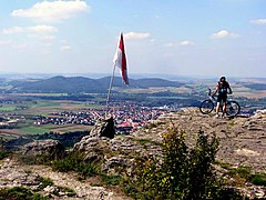
View from Staffelberg to Bad Staffelstein and the Eierberge
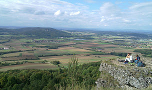
View from Staffelberg towards Coburg

High plateau
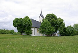
Adelgundis Chapel
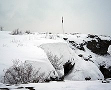
Staffelbergfelsen in winter

Staffelberg in winter

View from the main valley to the Staffelberg


Individual evidence
- ↑ a b Map services of the Federal Agency for Nature Conservation ( information )
- ↑ Christine Schweßinger: Geology is as exciting as a thriller. The Staffelberg received the seal of approval "Bavaria's most beautiful geotopes" / information board revealed. (PDF; 100 kB) Obermain-Tagblatt . September 26, 2008. As of June 11, 2010.
- ^ Bavarian State Office for the Environment, Geotop Staffelberg SE von Staffelstein (accessed on October 14, 2017).
- ↑ Information board Juraprofil Staffelberg of the Bavarian State Ministry for Environment and Health . As of May 31, 2010.
- ↑ Dept. Geology of the Heinrich Heine University Düsseldorf : The Staffelberg educational trail ( memento of the original from December 19, 2005 in the Internet Archive ) Info: The archive link was automatically inserted and not yet checked. Please check the original and archive link according to the instructions and then remove this notice. . As of June 11, 2010.
- ^ Celtic city: excavations on Staffelberg. June 3, 2019, accessed August 18, 2019 .
- ↑ The pincer gate on the Staffelberg is bigger than expected. March 22, 2019, accessed August 18, 2019 .
- ↑ Staffelberg: Archaeologists are on the trail of the Celts. Retrieved August 18, 2019 .
- ↑ Jesus-Mobile on Staffelberg
See also
literature
- Björn-Uwe Abels : Guide to archaeological monuments in Bavaria, Franconia Volume 2: Archaeological Guide Upper Franconia . Konrad Theiss Verlag, Stuttgart 1986, ISBN 3-8062-0373-3 , pp. 171-176.
- Björn-Uwe Abels: The Celtic Settlement of the Staffelberg, in: Discoveries around the Staffelberg (Staffelstein 2015) 48-61.
- Björn-Uwe Abels and Helmut Voss, rare and beautiful, archaeological treasures from the prehistory and early history of Upper Franconia, CHW monographs 9 (Lichtenfels 2007).
- Günter Dippold: The Staffelberg . 2. Vol. Lichtenfels 1992/94.
- Konrad Radunz: The Staffelberg, an ancient fortification on the Obermain . Bayreuth 1971.
- Georg Stark: Little Staffelberg guide through the earth, landscape and settlement history d. Mountain . Lichtenfels 1963.
Web links
- The Staffelberg in prehistoric times - online exhibition by the Institute for Prehistory and Protohistory at the University of Erlangen
- Menosgada - an ancient city on the Obermain (Landscape Museum Obermain)
- The Staffelberg educational trail
- 360 ° panorama from the Staffelberg
- The Staffelberg in the Frankenwiki