Stublong
|
Stublong
City of Bad Staffelstein
Coordinates: 50 ° 4 ′ 41 ″ N , 11 ° 2 ′ 40 ″ E
|
|
|---|---|
| Height : | 310 m above sea level NHN |
| Area : | 6.55 km² |
| Residents : | 322 |
| Population density : | 49 inhabitants / km² |
| Incorporation : | January 1, 1978 |
| Postal code : | 96231 |
| Area code : | 09573 |
Stublang is part of the municipality of the Upper Franconian town of Bad Staffelstein in the Lichtenfels district .
geography
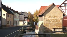
Stublang is about five kilometers east of Bad Staffelstein in a valley between Staffelberg and Ansberg, through which the Döritz brook flows to the west. At the western end of the village, the Döritz and the Döberten unite to form the Lauterbach, a left tributary of the Main . The state road 2204 runs past the site.
history
Stublang was first mentioned in a document in 1256 when Bishop Heinrich von Bamberg confirmed that Ramung and Friedrich von Plassenberg had left Serkendorf and goods in "Stuvelanc" Abbey Langheim in exchange for other substitutes.
The most important landlord, besides Langheim and lower aristocratic families, was the Bamberg Canons' Monastery of St. Stephan . In 1801 the parish had a branch church , a parish and shepherd's house and a brewery. The landlords were St. Stephan Abbey at 23 properties, Langheim Abbey at 6, Siechhof Bamberg at one, the Freiherren von Rotenhan zu Rentweinsdorf at 8, the Freiherren von Schaumberg at 4, the Counts of Giech zu Buchau at 8 and the senior council of the barons von Redwitz at 4. The Bamberger Hochstift , represented by the Vogteiamt Lichtenfels, ruled the village and community .
In the middle of the 19th century, farmers owned an average of 27 days' work in the agricultural town . In addition to livestock farming, there was also fruit growing. There were two mills on the Döritz. In 1807 a denominational school was founded in Stublang . The classroom was in the parish hall, above the forge. The community had a schoolhouse built between 1858 and 1861, which was then increased in 1896.
In 1862, Stublang was incorporated into the newly created Bavarian District Office Staffelstein . The rural community belonged to the Staffelstein District Court.
In 1871 Stublang had 310 inhabitants, 141 buildings and 57 residential buildings. The Catholic school was in the village, the branch church belonged to the parish of Uetzing, two kilometers away . In 1900, 334 people lived in the rural community of Stublang in 57 residential buildings and in 1925 289 people, all but one of whom were Catholic, lived in 55 residential buildings. In 1950 Stublang had 370 residents and 54 residential buildings. In 1970 the parish had 333 inhabitants, in 1987 315 inhabitants and 79 residential buildings with 99 apartments.
On July 1, 1972, the Staffelstein district was dissolved and Stublang has been part of the Lichtenfels district since then . On January 1, 1978, the community was incorporated into Staffelstein.
Population development
| year | population |
|---|---|
| 1686 | 255 |
| 1811 | 271 |
| 1840 | 331 |
| 1871 | 310 |
| 1900 | 334 |
| 1933 | 282 |
| 1946 | 393 |
| 1970 | 333 |
| 1987 | 315 |
Attractions
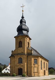
The Catholic branch church St. Nikolaus and St. Gumbertus is on the Döritz in the west on the outskirts. The sandstone block building with a retracted choir and single-tower facade was built in 1777–80 as a successor to a dilapidated old chapel according to plans by the Bamberg master craftsman Conrad Fink. The three-storey west tower with a square layout has a small vestibule to the nave on the ground floor . The church building is characterized by a uniform structure. The building cost around 5182 guilders.
Two small breweries with attached inns have been in Stublang since the middle of the 19th century. The list of architectural monuments in Stublang includes 20 sights.
literature
- Günter Dippold, Elmar Kerner: 225 years of the Church of St. Nikolaus and St. Gumbertus in Stublang . Stublang 2005.
Web links
Individual evidence
- ↑ Appendix for the preparation of the offer analysis according to the guideline for local transport planning for the district of Lichtenfels, 2015; P. 10.
- ^ A b Dorothea Fastnacht: Staffelstein. Former district of Staffelstein. Historical book of place names of Bavaria. Upper Franconia. Volume 5: Staffelstein. Commission for Bavarian State History, Munich 2007, ISBN 978-3-7696-6861-2 . Pp. 367-368.
- ↑ Günter Dippold, Elmar Kerner: 225 years of the Church of St. Nikolaus and St. Gumbertus in Stublang . Pp. 28-30.
- ↑ a b Kgl. Statistical Bureau (ed.): Complete list of localities of the Kingdom of Bavaria. According to districts, administrative districts, court districts and municipalities, including parish, school and post office affiliation ... with an alphabetical general register containing the population according to the results of the census of December 1, 1875 . Adolf Ackermann, Munich 1877, 2nd section (population figures from 1871, cattle figures from 1873), Sp. 1121. , Urn : nbn: de: bvb: 12-bsb00052489-4 ( digitized version ).
- ↑ a b K. Bayer. Statistical Bureau (Ed.): Directory of localities of the Kingdom of Bavaria, with alphabetical register of places . LXV. Issue of the contributions to the statistics of the Kingdom of Bavaria. Munich 1904, Section II, Sp. 1119 . ( Digitized version ).
- ↑ Bavarian State Statistical Office (ed.): Localities directory for the Free State of Bavaria according to the census of June 16, 1925 and the territorial status of January 1, 1928 . Issue 109 of the articles on Bavaria's statistics. Munich 1928, Section II, Sp. 1156 . ( Digitized version ).
- ↑ Bavarian State Statistical Office (ed.): Official place directory for Bavaria - edited on the basis of the census of September 13, 1950 . Issue 169 of the articles on Bavaria's statistics. Munich 1952, DNB 453660975 , Section II, Sp. 1001 . ( Digitized version ).
- ↑ a b Bavarian State Statistical Office (Hrsg.): Official local directory for Bavaria . Issue 335 of the articles on Bavaria's statistics. Munich 1973, DNB 740801384 , p. 164 . ( Digitized version ).
- ↑ a b Bavarian State Office for Statistics and Data Processing (Ed.): Official local directory for Bavaria, territorial status: May 25, 1987 . Issue 450 of the articles on Bavaria's statistics. Munich November 1991, DNB 94240937X , p. 318 . ( Digitized version ).
- ↑ a b c d e Günter Dippold, Elmar Kerner: 225 years of the Church of St. Nikolaus and St. Gumbertus in Stublang . P. 48.
- ↑ Günter Dippold, Elmar Kerner: 225 years of the Church of St. Nikolaus and St. Gumbertus in Stublang . Pp. 49-50.


