Nedensdorf
|
Nedensdorf
City of Bad Staffelstein
Coordinates: 50 ° 6 ′ 55 ″ N , 10 ° 58 ′ 1 ″ E
|
|
|---|---|
| Height : | 257 m above sea level NHN |
| Residents : | 251 (2014) |
| Incorporation : | July 1, 1972 |
| Incorporated into: | Banz |
| Postal code : | 96231 |
| Area code : | 09573 |
|
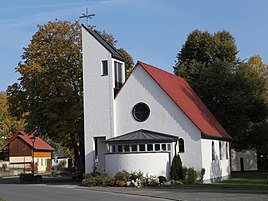
Catholic Church of Mary Queen
|
|
Nedensdorf is a district of the Upper Franconian town of Bad Staffelstein in the Lichtenfels district .
geography
Nedensdorf is about eight kilometers southwest of Lichtenfels am Main . Occasionally, a wooden barge serves as a cable ferry to transport people across the river. South of Nedensdorf is the main slope of the Main on the Trimeusel with a striking Lias outcrop. The high-speed line Nuremberg – Erfurt runs to the west . The main tributaries Weidigsgraben and Schmiedsgraben cross the place. The Franconian Marienweg runs through Nedensdorf .
history
Nedensdorf was mentioned for the first time in the 9th century in the traditions of the Fulda Monastery , which are based on a copy in the Codex Eberhardi from the 12th century. The next mention is documented for 1139, when the abbot Baldwin from Banz Monastery acquired the allod "Nedimstorf" from Pillung von Memmelsdorf .
1801 belonged high centering the Hochstift Bamberg , the village, municipal, and advocacy Lehen- rule the Banz. The residents were parish to Altenbanz . The place had a parish hall, a shepherd's house and a desolate brewery. There were also three farms, five estates, twelve half estates and thirteen Sölden estates in Nedensdorf. In 1862 Nedensdorf and its Neuhof district were incorporated into the newly created Bavarian district office of Staffelstein .
In 1871 Nedensdorf had 312 residents and 164 buildings as well as its own school. The Catholic Church was in Banz Monastery, 3.5 kilometers away. In 1890 the volunteer fire brigade was founded. In 1900 the rural community of Nedensdorf comprised an area of 540.07 hectares, 264 inhabitants, all of whom were Catholic, and 48 residential buildings. 249 people lived in 46 residential buildings in Nedensdorf. The responsible Protestant parish was in Herreth . In 1925, 218 people lived in 42 residential buildings, in 1950 there were 285 residents and 42 residential buildings. In 1970 the place had 229 inhabitants and 1987 246 inhabitants and 62 residential buildings.
On July 1, 1972, Nedensdorf merged with its district of Neuhof and the neighboring communities of Altenbanz, Stadel , Unnersdorf and parts of Weingarten to form the new community of Banz , which was dissolved on January 1, 1978 and incorporated into the town of Staffelstein. Since then, Nedensdorf has been a district of Staffelstein.
On July 1, 1972, the Staffelstein district was dissolved and Nedensdorf was incorporated into the Lichtenfels district.
Attractions
The Catholic branch church Maria Königin was built in 1957 as a modern hall church with a semicircular end. The Bamberg artist Anton Greiner decorated them with wall paintings. In 1996 the church tower and the sacristy were added.
Many breweries were founded in Upper Franconia from 1805, when middle-class people also received the right to brew. It is the year the Reblitz brewery was founded. The beer output is around 400 hectoliters per year. The Leicht brewery existed from 1902 to 1985.
In the list of architectural monuments in Nedensdorf further sights are listed.
Web links
Individual evidence
- ↑ VGN GmbH (Ed.): Local transport plan, preparation of the offer analysis, table template . September 2, 2015, p. 11 ( Table template ( Memento from October 22, 2016 in the Internet Archive )).
- ^ A b Dorothea Fastnacht: Staffelstein. Former district of Staffelstein. Historical book of place names of Bavaria. Upper Franconia. Volume 5: Staffelstein. Commission for Bavarian State History, Munich 2007, ISBN 978 3 7696 6861 2 . P. 248
- ↑ Kgl. Statistical Bureau (ed.): Complete list of localities of the Kingdom of Bavaria. According to districts, administrative districts, court districts and municipalities, including parish, school and post office affiliation ... with an alphabetical general register containing the population according to the results of the census of December 1, 1875 . Adolf Ackermann, Munich 1877, 2nd section (population figures from 1871, cattle figures from 1873), Sp. 1120 , urn : nbn: de: bvb: 12-bsb00052489-4 ( digitized ).
- ↑ K. Bayer. Statistical Bureau (Ed.): Directory of localities of the Kingdom of Bavaria, with alphabetical register of places . LXV. Issue of the contributions to the statistics of the Kingdom of Bavaria. Munich 1904, Section II, Sp. 1118 ( digitized version ).
- ↑ Bavarian State Statistical Office (ed.): Localities directory for the Free State of Bavaria according to the census of June 16, 1925 and the territorial status of January 1, 1928 . Issue 109 of the articles on Bavaria's statistics. Munich 1928, Section II, Sp. 1155 ( digitized version ).
- ↑ Bavarian State Statistical Office (ed.): Official place directory for Bavaria - edited on the basis of the census of September 13, 1950 . Issue 169 of the articles on Bavaria's statistics. Munich 1952, DNB 453660975 , Section II, Sp. 1000 ( digitized version ).
- ^ Bavarian State Statistical Office (ed.): Official place directory for Bavaria . Issue 335 of the articles on Bavaria's statistics. Munich 1973, DNB 740801384 , p. 163 ( digitized version ).
- ↑ Bavarian State Office for Statistics and Data Processing (Ed.): Official local directory for Bavaria, territorial status: May 25, 1987 . Issue 450 of the articles on Bavaria's statistics. Munich November 1991, DNB 94240937X , p. 318 ( digitized version ).
- ↑ http://www.kirchbau.de/php/300_datenblatt.php?id=15635&name=keiner

