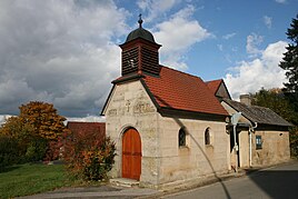
Zilgendorf
|
Zilgendorf
City of Bad Staffelstein
Coordinates: 50 ° 10 ′ 5 ″ N , 10 ° 57 ′ 50 ″ E
|
|
|---|---|
| Height : | 315 m above sea level NHN |
| Residents : | 33 (2014) |
| Incorporation : | 1978 |
| Postal code : | 96231 |
| Area code : | 09565 |
|
Village chapel and bakery
|
|
Zilgendorf is a district of the Upper Franconian town of Bad Staffelstein in the Lichtenfels district .
geography
The hamlet of Zilgendorf is located eleven kilometers south of Coburg and nine kilometers west of Lichtenfels in the north of a long triangle between Itz and Main . The place is located to the northwest at the foot of Mount Kulch. The high-speed line Nuremberg – Erfurt runs to the east .
history
The first documented mention of "Circhendorf" was in 1139, when Pope Innocent II confirmed the place as legally acquired by Bishop Otto of Bamberg . In 1295 the Cistercians from Langheim Abbey exchanged all possessions in Zilgendorf for all goods belonging to the Benedictines from Banz Abbey in Messenfeld . In 1801 the district was Bamberg and the rulership of the village belonged to the Banz monastery .
The brewery and restaurant Gick founded Adam Hornung in 1870. From 1925 operational Marie Gick and from 1933 Johann Gick the business. In 1998 the brewing business was stopped. After that, the inn was only open on Sundays.
In 1871 Zilgendorf had 83 residents and 40 buildings. The school and the Catholic Church were in Altenbanz, 1.5 kilometers away. In 1900 54 people lived in twelve residential buildings and in 1925 a total of 51 people lived in nine residential buildings. In 1950 Zilgendorf had 99 inhabitants and nine residential buildings, unchanged. In 1970 the place had 61 inhabitants and in 1987 a total of 40 inhabitants and ten residential buildings.
On July 1, 1972, Altenbanz merged with its district of Zilgendorf and the neighboring communities of Stadel , Nedensdorf , Unnersdorf and parts of Weingarten to form the new community of Banz , which was dissolved on January 1, 1978 and incorporated into the town of Bad Staffelstein . Since then, Zilgendorf has been a district of Staffelstein.
On July 1, 1972, the Staffelstein district was dissolved. Since then, Zilgendorf has been part of the Lichtenfels district.
Attractions
Sights are listed in the list of architectural monuments in Zilgendorf .
Web links
- Zilgendorf in the location database of the Bavarian State Library Online . Bavarian State Library
Individual evidence
- ↑ VGN GmbH (Ed.): Local transport plan, preparation of the offer analysis, table template . September 2, 2015, p. 13 ( Table template ( Memento from October 22, 2016 in the Internet Archive )).
- ^ A b Dorothea Fastnacht: Staffelstein. Former district of Staffelstein. Historical book of place names of Bavaria. Upper Franconia. Volume 5: Staffelstein. Commission for Bavarian State History, Munich 2007, ISBN 978 3 7696 6861 2 . P. 430 f.
- ↑ Wolfgang Vatke, Karl-Heinz Müller: Historical Lichtenfelser Brewery Guide . Veste-Verlag Coburg H. Roßteutscher, Coburg 2000, p. 116
- ↑ Kgl. Statistical Bureau (ed.): Complete list of localities of the Kingdom of Bavaria. According to districts, administrative districts, court districts and municipalities, including parish, school and post office affiliation ... with an alphabetical general register containing the population according to the results of the census of December 1, 1875 . Adolf Ackermann, Munich 1877, 2nd section (population figures from 1871, cattle figures from 1873), Sp. 1119 , urn : nbn: de: bvb: 12-bsb00052489-4 ( digitized version ).
- ↑ K. Bayer. Statistical Bureau (Ed.): Directory of localities of the Kingdom of Bavaria, with alphabetical register of places . LXV. Issue of the contributions to the statistics of the Kingdom of Bavaria. Munich 1904, Section II, Sp. 1117 ( digitized version ).
- ↑ Bavarian State Statistical Office (ed.): Localities directory for the Free State of Bavaria according to the census of June 16, 1925 and the territorial status of January 1, 1928 . Issue 109 of the articles on Bavaria's statistics. Munich 1928, Section II, Sp. 1153 ( digitized version ).
- ↑ Bavarian State Statistical Office (ed.): Official place directory for Bavaria - edited on the basis of the census of September 13, 1950 . Issue 169 of the articles on Bavaria's statistics. Munich 1952, DNB 453660975 , Section II, Sp. 997 ( digitized version ).
- ^ Bavarian State Statistical Office (ed.): Official place directory for Bavaria . Issue 335 of the articles on Bavaria's statistics. Munich 1973, DNB 740801384 , p. 163 ( digitized version ).
- ↑ Bavarian State Office for Statistics and Data Processing (Ed.): Official local directory for Bavaria, territorial status: May 25, 1987 . Issue 450 of the articles on Bavaria's statistics. Munich November 1991, DNB 94240937X , p. 318 ( digitized version ).

