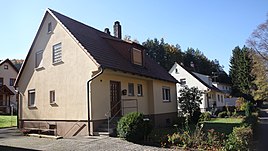
Tiefenthal (Bad Staffelstein)
|
Tiefenthal
City of Bad Staffelstein
Coordinates: 50 ° 3 ′ 56 ″ N , 11 ° 5 ′ 1 ″ E
|
|
|---|---|
| Height : | 376 m above sea level NHN |
| Residents : | 11 (1987) |
| Incorporation : | 1978 |
| Postal code : | 96231 |
| Area code : | 09573 |
|
Tiefenthal
|
|
Tiefenthal is a district of the Upper Franconian town of Bad Staffelstein in the Lichtenfels district .
geography
Tiefenthal is located about seven kilometers southeast of Bad Staffelstein at the foot of the Weißjura plateau east of the Main Valley . The Tiefentalbach flows past the hamlet . A road to the Lautergrund rehabilitation clinic of the German Pension Insurance Berlin-Brandenburg leads through Tiefenthal.
history
The place was first mentioned in 1413 in the interest income of the abbot of Michelsberg Monastery as "Tiffental". The place name was only used as a field name for centuries. It means unfathomable valley. In 1880 the Wagner journeyman Johann Schnappauf built a house in Tiefenthal, which was later extended to a mill. In 1904 a stable and a cutting saw were built, and in 1912 a barn.
The Einöde Tiefenthal was first mentioned in 1950 as part of the Schwabthaler municipality among the new settlements reported by the municipalities . The official name followed in the 1950s. The mill buildings were demolished in 1966 in the course of the expansion of the Lautergrund pulmonary hospital. The mill wheel was preserved.
In the census of September 13, 1950, the wasteland counted a residential building with five residents. The Catholic school and church were in Frauendorf , the Protestant parish in Staffelstein 1961 Tiefenthal had ten residents and three residential buildings, in 1970 the numbers were unchanged. In 1987, eleven people lived in three residential buildings with four apartments in the hamlet.
On July 1, 1972, the Staffelstein district was dissolved and Schwabthal and Tiefenthal were incorporated into the Lichtenfels district. On January 1, 1978 the incorporation to Staffelstein followed.
Web links
Individual evidence
- ↑ a b Bavarian State Office for Statistics and Data Processing (Ed.): Official local directory for Bavaria, territorial status: May 25, 1987 . Issue 450 of the articles on Bavaria's statistics. Munich November 1991, DNB 94240937X , p. 318 ( digitized version ).
- ^ A b Dorothea Fastnacht: Staffelstein. Former district of Staffelstein. Historical book of place names of Bavaria. Upper Franconia. Volume 5: Staffelstein. Commission for Bavarian State History, Munich 2007, ISBN 978-3-7696-6861-2 . P. 379.
- ↑ a b Adelheid Waschka: Das Tiefenthal. Shield of the Celtic round tour H.
- ↑ Bavarian State Statistical Office (ed.): Official place directory for Bavaria - edited on the basis of the census of September 13, 1950 . Issue 169 of the articles on Bavaria's statistics. Munich 1952, DNB 453660975 , Section II, Sp. 1001 ( digitized version ).
- ↑ Bavarian State Statistical Office (ed.): Official city directory for Bavaria, territorial status on October 1, 1964 with statistical information from the 1961 census . Issue 260 of the articles on Bavaria's statistics. Munich 1964, DNB 453660959 , Section II, Sp. 736 ( digitized version ).
- ^ Bavarian State Statistical Office (ed.): Official place directory for Bavaria . Issue 335 of the articles on Bavaria's statistics. Munich 1973, DNB 740801384 , p. 164 ( digitized version ).

