Meadows (Bad Staffelstein)
|
grasslands
City of Bad Staffelstein
Coordinates: 50 ° 5 ′ 46 ″ N , 10 ° 57 ′ 4 ″ E
|
|
|---|---|
| Height : | 253 m above sea level NHN |
| Residents : | 270 (2014) |
| Incorporation : | 1st January 1975 |
| Postal code : | 96231 |
| Area code : | 09573 |
|
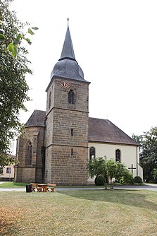
Catholic branch church St. Andreas
|
|
Wiesen is a district of Bad Staffelstein on the northern bank of the Main in the Lichtenfels district .
history
Wiesen used to be a fishing village on a bend in the Main. The first mention as "Vuison" was 1057 or earlier. Otto von Schweinfurt had given the place to his daughter Alberata and her servant Bero in the Villication Döringstadt . The former hamlet of Mittelau was first mentioned in a document in 1240.
Presumably in 1834, the Main received a new river bed about 400 meters further east. In 1877 the first fixed main crossing was built with a wooden girder bridge. In 1900 the parish village had 213 residents, all of whom were Catholic, and 35 residential buildings.
On January 1, 1975, the municipality of Wiesen was incorporated into the town of Staffelstein. In 1987 the place had 241 residents and 62 residential buildings. In the competition Our village should become more beautiful - our village has a future , the place was able to place itself in 1998 among the 23 most beautiful places in Bavaria. In 2006 the district garden day took place in Wiesen.
Others
- The village has two breweries with restaurants
- Bathing lake with connection to the Main (Wörthsee Wiesen)
- The Franconian Marienweg runs through the village .
literature
- Norbert Jung, Günter Dippold, Franz Böhmer: 500 years of St. Andreas in Wiesen , Staffelstein-Wiesen, self-publishing. the Catholic Church Foundation St. Andreas Wiesen, 2000, ISBN 3-926621-13-3
- Hubert Kolling: The raft trip was a good service - the Main breakthrough at Wiesen in 1834 . In: Heimatgeschichtliche Zeitschrift für die Landkreis Lichtenfels , Volume 16/17 - 2008, Verlag Vom Main zum Jura, Eggolsheim 2008, pp. 32–56
- Josef Schröder: Meadows - at the foot of the Eierberge , o. O, o. J. (approx. 1994) - information brochure of the Lichtenfels district
Web links
Individual evidence
- ↑ VGN GmbH (Ed.): Local transport plan, preparation of the offer analysis, table template . September 2, 2015, p. 11 ( Table template ( Memento from October 22, 2016 in the Internet Archive )).
- ^ Dorothea Fastnacht: Staffelstein. Former district of Staffelstein. Historical book of place names of Bavaria. Upper Franconia. Volume 5: Staffelstein. Commission for Bavarian State History, Munich 2007, ISBN 978-3-7696-6861-2 . P. 412.
- ↑ K. Bayer. Statistical Bureau (Ed.): Directory of localities of the Kingdom of Bavaria, with alphabetical register of places . LXV. Issue of the contributions to the statistics of the Kingdom of Bavaria. Munich 1904, Section II, Sp. 1120 ( digitized version ).
- ^ Federal Statistical Office (ed.): Historical municipality directory for the Federal Republic of Germany. Name, border and key number changes in municipalities, counties and administrative districts from May 27, 1970 to December 31, 1982 . W. Kohlhammer GmbH, Stuttgart / Mainz 1983, ISBN 3-17-003263-1 , p. 694 .
- ↑ Bavarian State Office for Statistics and Data Processing (Ed.): Official local directory for Bavaria, territorial status: May 25, 1987 . Issue 450 of the articles on Bavaria's statistics. Munich November 1991, DNB 94240937X , p. 318 ( digitized version ).

