
List of architectural monuments in Bad Staffelstein
 Ensembles: Bad Staffelstein old town • Pilgrimage church of Vierzehnheiligen Monuments according to districts: Bad Staffelstein • Altenbanz • End • Forsthaus Banz • Frauendorf • Gößmitz • Grundfeld • Hausen • Herrgottsmühle • Horsdorf • Kaider • Banz Monastery • Krögelhof • Loffeld • Nedensdorf • Oberau • Püchitz • Romansthal • Schönbrunn • Schwabthal • Serkendorf • Stadel • Staffelberg • Stublang • Uetzing • Unnersdorf • Unterzettlitz • Vierzehnheiligen • Weisbrem • Wiesen • Wolfsdorf • Zilgendorf |
The monuments of the Upper Franconian town of Bad Staffelstein are compiled on this page . This table is a partial list of the list of architectural monuments in Bavaria . The basis is the Bavarian Monument List , which was first drawn up on the basis of the Bavarian Monument Protection Act of October 1, 1973 and has since been managed by the Bavarian State Office for Monument Preservation . The following information does not replace the legally binding information from the monument protection authority.
Ensembles
Ensemble old town Bad Staffelstein


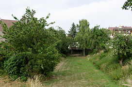
The ensemble ( location ) includes the old town of Bad Staffelstein within the fortification ring from the 14th and 15th centuries. According to the local archaeological sites, which go back from the Merovingian tombs to the Thuringian culture of the 1st century, a description of the Banz manor dated around 800 represents the earliest mention of today's settlement area. The parish of Sankt Kilian was founded before 1007, before 1120 / 1124 the Fronhof of the place came to the cathedral chapter Bamberg, 1130 the settlement got market rights , whereby the situation on a road connection from Bamberg to Central Germany had a favorable effect. With the acquisition of the majority of the land and full jurisdiction in the 14th and early 15th centuries, the cathedral chapter promoted the expansion of the city and in 1422 its fortification . In 1473 the city, including the parish church and the town hall, burned down. The fact that the bishopric of Bamberg as sovereign rulership and its local office, the Kastenhof, was largely deprived of sovereign power over the city in the early modern period represents a local special situation. After the Thirty Years' War spread to the city, especially in 1633, 1684 Almost the entire place, 340 buildings with the exception of a small area around the parish church, the flames. The symbol of the subsequent reconstruction is the town hall from 1686/87. In the years that followed, the economic structure of the town's craft, trade and accommodation businesses was heavily geared towards the nearby monasteries and pilgrimage sites of Banz, Langheim and Vierzehnheiligen. After the incorporation into the Kingdom of Bavaria in 1803, the place lost its official function. The connection to the railway network in 1846 enabled new economic developments. Between 1862 and 1972 the place was again the official seat. In the present, the small town is determined by its function as a health resort on the basis of the thermal brine developed in 1975. The brine has been used in a thermal bath since 1986, which in 2001 led to the city being awarded the title “Bath”. The roughly oval city plan is bounded in the west by two arms of the Lauter, a tributary of the Main, which were probably channeled with the construction of the city fortifications, and on the other sides by partly clearly deepened, artificial moat zones. Within the Bering, the west-east connection Bamberger Straße-Marktplatz-Lichtenfelser Straße, the north-south connection Bahnhofstraße-Marktplatz-Horsdorfer Straße and the market next to the intersection occupy the most important positions. Due to the off-center location of this street cross, Kirchgasse in the northwest is also to be assessed as the main street. All other streets, originally mostly dead ends, have subordinate functions. With the largely regular floor plan constellation, the separate, unusually far removed location of the parish church of St. Kilian is striking. Of particular importance is the closed appearance of the buildings, which is characterized by the reconstruction after the city fire of 1684. These include mostly two-story, often gable front houses with ornamental frameworks on the upper floor. An important urban focus is the market square, which was already mentioned as prominent in the 12th century, with the three-storey town hall located approximately in the middle. Other representative secular buildings with a solitary position are the former office of the Bamberg cathedral chapter (today the office for agriculture) and the city museum. In addition to the parish church, the Sankt Anna-Kapelle, located directly on the trade route, and the Sankt Georg-Kapelle in the area of the former Kastenhof are to be mentioned. In addition to the remains of the wall and larger sections of the green ring, the Bamberg gate tower, essentially from the 16th century, has been preserved from the city fortifications. In particular in the northern section of Bahnhofstrasse and Kirchgasse there are a few buildings from the 19th century within the ensemble or buildings whose external appearance was shaped during this period. Due to their urban position in corner and gate situations, the buildings Bahnhofstrasse 47 and Kirchgasse 1 are important for the ensemble. The tower of the parish church of the 14th / 15th centuries stands out in the silhouette of the town at the foot of the Staffelberg. Century, the town hall and the Bamberg gate tower of the 16./18. Century as a dominant feature of the cityscape. File number: E-4-78-165-1.
Ensemble pilgrimage church Vierzehnheiligen

The ensemble ( location ) includes the basilica as a pilgrimage church and its immediate surroundings with the Propsteigebuilding of the Franciscan monastery, two inns, a brewery , the stationary, standardized stalls for devotional items and the slope adjacent to the north with the Way of the Cross, which is particularly relevant for long-distance effects. Mention of the location begins in 1344 with the acquisition of the Frankenthal farm by the Cistercian monastery Langheim from the von Kunstadt family . The place to which the apparitions of the 14 emergency helpers in the years 1445/46 is ascribed, the later location of the basilica, lies a little uphill south of the location of Hof Frankenthal, before the actual ascent to the Jura plateau . The first pilgrimage church was consecrated here in 1448, the history of the Goldener Hirsch pilgrimage hostel can be traced back to 1458. Construction of the basilica began in 1743 and was completed with its consecration in 1772. After the abolition of the Langheim monastery in 1803 and the destruction of the spiers and roofs of the Vierzehnheiliger basilica by fire in 1835, the Franciscan order took over the execution of the pilgrimages in 1839 . Various buildings for the direct supply of pilgrims were built at the end of the 19th and beginning of the 20th century. In the immediate vicinity of the ensemble, the St. Francis Sisters took over the Frankenthal farm in 1913 and expanded it to become the Antoniusheim. From 1968 the diocesan house was built on this site. Immediately to the west of it, the new parent house of the Saint Francis Sisters was built from 1928 and expanded several times until 1986. The Konradshof north below the pilgrimage church, which has existed in its current form since 2001, also belongs to this order. The baroque basilica is at the center of the ensemble area. Its towers and the entire exterior architecture radiate far into the surrounding area. The provost building of the Franciscan order from 1746 is spatially and architecturally aligned directly with the basilica. The order cemetery, which is flanked by baroque stations of the cross, is in the immediate vicinity. To the west of the double tower facade are the Goldener Hirsch, Goldener Stern restaurants and the stalls down the slope. The northern slope areas free of buildings and only sparsely planted with large greenery are of particular importance for the extraordinarily high spatial impact of the basilica and the ensemble as a whole, while the edge of the forest forms the horizon line in the south. File number: E-4-78-165-2.
City fortifications
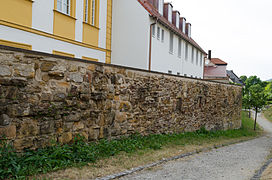
The city fortifications include a simple bering with the city wall made of sandstone blocks and a city moat. It was created in the 15th and 16th centuries. The moat area has been preserved on the Ringstrasse in the northeast and in the east as well as Am Stadtgraben in the south. Longer sections of the city wall have been preserved in the east along the Ringstrasse, in the south along Am Stadtgraben and in the west along Am Unteren Lauterdamm. The wall towers have come off. Of the gates, only the Bamberg gate tower has been preserved. File number: D-4-78-165-325.

City wall and moat at the city moat
Graben am Stadtgraben
City wall in the eastern part of the Ringstrasse
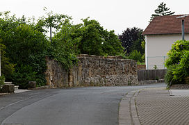
City wall east of the Bamberg gate tower


| location | object | description | File no. | image |
|---|---|---|---|---|
| Bamberger Straße 25 ( location ) |
Bamberg Gate Tower | Five-storey sandstone square tower with a mansard tent roof, 16./18. Century, 18th century spire, probably based on a design by Johann Jakob Michael Küchel | D-4-78-165-46 |
 more pictures |
| Bahnhofstrasse 39 ( location ) |
city wall | 15./16. century | D-4-78-165-28 |
Architectural monuments according to districts
Bad Staffelstein
| location | object | description | File no. | image |
|---|---|---|---|---|
| Old shooting range 1 ( location ) |
Residential building | Two-storey mansard roof building, the back leaning against the city wall, second third of the 18th century | D-4-78-165-2 |
.JPG) more pictures |
| Am Kreuzberg, Alte Schießstätte ( location ) |
crucifix | Sandstone, inscribed "1717" | D-4-78-165-101 | |
| Am Stadtgraben 3 ( location ) |
Half-timbered barn | With a half-hipped roof, around 1800 | D-4-78-165-326 |
 more pictures |
| Am Stadtgraben 7 ( location ) |
Mansard half hipped roof building | Two-storey, plastered half-timbered upper storey, second half of the 18th century, with a two-storey saddle roof extension from the 19th century | D-4-78-165-3 | |
| Near Am Unteren Lauterdamm ( location ) |
Wayside shrine | Sandstone (without column), Corinthian capital, four-sided top, early 18th century | D-4-78-165-92 | |
| Close to Schwedenleite, at the Siechenstraße junction ( location ) |
Crucifixion group | Wood, 19th century, in a wall niche | D-4-78-165-51 | |
| Angerstrasse ( location ) |
Saint John Nepomuk sculpture | Sandstone, first half of the 18th century | D-4-78-165-374 |
 more pictures |
| Angerstrasse 3 ( location ) |
Residential building | Two-story hipped roof building, core 18th century | D-4-78-165-5 |
.JPG) more pictures |
| Angerstrasse 5 ( location ) |
Residential building | Two-story saddle roof building, plastered half-timbered upper floor, late 17th century | D-4-78-165-6 |
 more pictures |
| Angerstrasse 10 ( location ) |
Residential building | Two-storey eaves half-hipped roof house, plastered half-timbered upper storey, early 19th century | D-4-78-165-7 |
.JPG) more pictures |
| Angerstrasse 12 ( location ) |
Half hipped roof house | Two-storey, eaves, plastered half-timbered upper storey, late 17th / early 18th century | D-4-78-165-8 |
.JPG) more pictures |
| Bahnhofstrasse 1 ( location ) |
Residential and commercial building | Two-storey corner house with a gable roof, plastered half-timbered upper floor, 17th / 19th century Century, modern shop fitting on the ground floor | D-4-78-165-12 |
 more pictures |
| Bahnhofstrasse 5 ( location ) |
Barrel vaulted cellar | 16./17. Century; not re-qualified, not mapped in the Bavarian Monument Atlas | D-4-78-165-13 | |
| Bahnhofstrasse 9 ( location ) |
Gasthof Drei Kronen | Two-storey gable roof house with eaves, half-timbered upper storey, late 17th century | D-4-78-165-14 |
.JPG) more pictures |
| Bahnhofstrasse 11 ( location ) |
Residential and commercial building | Two-storey gable-roof house with eaves, plastered half-timbered upper storey, 18th century | D-4-78-165-15 |
 more pictures |
| Bahnhofstrasse 12 ( location ) |
Residential and commercial building | Two-storey hipped roof house with two-storey eaves saddle roof extension, half-timbered upper floor, late 17th century, modern shop fitting on the ground floor | D-4-78-165-16 |
 more pictures |
| Bahnhofstrasse 13 ( location ) |
Residential and commercial building | Two-storey hipped gable house, plastered half-timbering, second half of the 17th century | D-4-78-165-17 |
.JPG) more pictures |
| Bahnhofstrasse 15 ( location ) |
Residential and commercial building | Two-storey saddle-roof house, half-hipped on the street side, plastered half-timbering, 18th century, modern shop fitting on the ground floor | D-4-78-165-18 |
.JPG) more pictures |
| Bahnhofstrasse 16 ( location ) |
Residential and commercial building | Two-storey saddle roof house, hip on the street side, half-timbered, plastered on the ground floor, late 17th / early 18th century, modern shop fitting on the ground floor | D-4-78-165-19 |
 more pictures |
| Bahnhofstrasse 19 ( location ) |
Residential building | Two-storey gable-roof house, plastered half-timbering, second half of the 18th century | D-4-78-165-20 |
.JPG) more pictures |
| Bahnhofstrasse 22 ( location ) |
Marienapotheke | Two-story hipped gable roof house, plastered half-timbered upper floor, 17th / 18th centuries Century, modern shop fitting on the ground floor | D-4-78-165-21 |
 more pictures |
| Bahnhofstrasse 23 ( location ) |
Residential and commercial building | Two-storey eaves gable-roof house, half-hipped in the south, half-timbered upper floor, late 17th / early 18th century, modern shop fitting on the ground floor | D-4-78-165-22 |
 more pictures |
| Bahnhofstrasse 26 ( location ) |
Residential building | Single-storey building with hipped gable, 18th / 19th centuries century | D-4-78-165-24 |
.JPG) more pictures |
| Bahnhofstrasse 27 ( location ) |
Residential and commercial building | Three-storey hipped roof building, plastered half-timbered upper floors, 17th / 18th centuries Century, modern shop fitting on the ground floor | D-4-78-165-23 |
 more pictures |
| Bahnhofstrasse 27 ( location ) |
Rear building | Two-storey half-hipped roof building with a former portico, 18th century | D-4-78-165-23 | |
| Bahnhofstrasse 28 ( location ) |
Residential and commercial building | Two-storey building with a hipped roof, half-timbered upper floor, 18th / 19th century. century | D-4-78-165-25 |
.JPG) more pictures |
| Bahnhofstrasse 29 ( location ) |
Barrel vaulted cellar | Made of sandstone blocks, 16./17. Century; not re-qualified, not mapped in the Bavarian Monument Atlas | D-4-78-165-26 | |
| Bahnhofstrasse 37 ( location ) |
Residential building | Two-storey eaves gable-roof house from the 18th century with half-timbered extension | D-4-78-165-27 |
.JPG) more pictures |
| Bahnhofstrasse 45 ( location ) |
Residential building | Two-story gable roof house with eaves, 17th / 18th centuries century | D-4-78-165-30 |
.JPG) more pictures |
| Bahnhofstrasse 62 ( location ) |
Villa Marie | Two-storey hipped roof building with corner towers and a staircase at the side, around 1900 | D-4-78-165-32 |
.JPG) more pictures |
| Bahnhofstrasse 75 ( location ) |
Schrepfersmühle | Two-story hipped roof building, plastered half-timbering, early 18th century, modern shop fitting on the ground floor | D-4-78-165-33 |
.JPG) more pictures |
| Bahnhofstrasse 101 ( location ) |
Station building | Sandstone block construction, two-storey central wing with a gable roof between two single-storey wing structures with half-hipped trees, 1845, based on plans by the gardening school (Friedrich Bürklein) | D-4-78-165-34 |
 more pictures |
| Bamberger Straße 1 ( location ) |
Adam Riese Inn | Two-storey gable-roof house, half-hipped on the street side, half-timbered upper storey, second half of the 17th century | D-4-78-165-35 |
 more pictures |
| Bamberger Straße 3 ( location ) |
Residential and commercial building | Two-storey gable-roof house, half-hipped on the street side, plastered half-timbered upper floor, around 1685, modern shop fitting on the ground floor | D-4-78-165-36 |
 more pictures |
| Bamberger Straße 5 ( location ) |
Residential and commercial building | Two-story gable-roof house, half-hipped on the street side, plastered half-timbered upper floor, late 17th century, modern shop fitting on the ground floor | D-4-78-165-37 |
 more pictures |
| Bamberger Straße 6 ( location ) |
Residential and commercial building | Two-storey saddle-roofed house, half-hipped on the street side, plastered half-timbered upper floor, late 17th / early 18th century, modern shop fitting on the ground floor | D-4-78-165-38 |
.JPG) more pictures |
| Bamberger Straße 7 ( location ) |
St. Anna Catholic Chapel | Gable roof construction on the eaves side with roof turrets, retracted choir, hall, 15. – 17. Century, with equipment | D-4-78-165-39 |
 more pictures |
| Bamberger Straße 8 ( location ) |
Residential and commercial building | Two-storey gable-roof house with eaves, plastered half-timbered upper storey, late 17th century | D-4-78-165-40 |
.JPG) more pictures |
| Bamberger Straße 9 ( location ) |
Residential and commercial building | Two-storey gable-roof house, half-timbered, labeled "1684", modern shop fitting on the ground floor | D-4-78-165-41 |
 more pictures |
| Bamberger Straße 9a ( location ) |
Rear building | Two-storey, half-timbered, with a gable roof, late 17th century | D-4-78-165-41 | |
| Bamberger Straße 10 ( location ) |
Residential and commercial building | Two-storey gable roof house with eaves, plastered half-timbered upper storey, late 17th century, modern shop fitting on the ground floor | D-4-78-165-42 |
.JPG) more pictures |
| Bamberger Straße 12 ( location ) |
Residential and commercial building | Two-story saddle-roof house, half-hipped on the street side, plastered half-timbered upper floor, late 18th century, modern shop fitting on the ground floor | D-4-78-165-43 |
.JPG) more pictures |
| Bamberger Straße 13 ( location ) |
Residential and commercial building | Two-storey gable-roof house with eaves, first half of the 19th century, modern shop fitting on the ground floor | D-4-78-165-44 |
.JPG) more pictures |
| Bamberger Straße 20 ( location ) |
Former hospital | Two-story plastered half-hipped roof house, half-timbered, last quarter of the 17th century, two-story extension with hipped roof, 1751 | D-4-78-165-45 |
 more pictures |
| Bamberger Straße 29 ( location ) |
Residential and commercial building | Two-storey half-hipped roof house, plastered half-timbered upper storey, late 17th century | D-4-78-165-47 |
 more pictures |
| Bamberger Straße 33 ( location ) |
Gasthof Gruener Baum | Multiple changes to the building complex with an older two-storey mansard roof middle section, plastered half-timbered upper storey, mid-18th century | D-4-78-165-48 |
.JPG) more pictures |
| Bamberger Straße 34 ( location ) |
Residential building | Two-storey saddle-roof house with knee-height and dwarf house, half-timbered upper floor, late 19th century | D-4-78-165-49 |
.JPG) more pictures |
| Bamberger Straße 43 ( location ) |
Holy Cross Catholic Chapel | Plastered building with sandstone structures, gable roof with ridge turret, retracted choir, rectangular nave, 1677/78, with furnishings | D-4-78-165-50 |
.JPG) more pictures |
| Bärengasse 3 ( location ) |
Residential building | Two-storey gable roof house with eaves, 18th century | D-4-78-165-10 |
.JPG) more pictures |
| Bärengasse 4 ( location ) |
Residential building | Two-story hipped roof house, plastered half-timbered upper floor, polygonal bay window, mid-18th century | D-4-78-165-327 |
.JPG) more pictures |
| Bärengasse 6 ( location ) |
Residential building | Two-story saddle roof building, plastered half-timbered upper floor, 17th / 18th centuries century | D-4-78-165-11 |
.JPG) more pictures |
| Bischof-von-Dinkel-Strasse 15 ( location ) |
Wayside shrine | Sandstone, column with ionizing capital, four-sided attachment with tent roof, second half of the 17th century, at the former plague cemetery | D-4-78-165-94 | |
| Bodenäcker, on the road leading to State Road 2197 ( location ) |
Wayside shrine | Sandstone, wine-entwined column with a four-sided top, late 17th century | D-4-78-165-96 | |
| Georg-Herpich-Platz 2 ( location ) |
Evangelical Lutheran Trinity Church | Pyramid roof building on a triangular floor plan, with bulges at the corners, with bell towers at the front, 1957 by Karl Pfeiffer-Haardt, with fittings | D-4-78-165-1 |
.JPG) more pictures |
| Georg-Herpich-Platz 3 ( location ) |
Rectory | Two-story hipped roof building, 1960 | D-4-78-165-1 | |
| Horsdorfer Straße 4 ( location ) |
Residential building | Two-storey gable-independent half-hipped roof house, plastered half-timbered upper floor, gable trapeze half-timbering, late 17th century | D-4-78-165-52 |
.JPG) more pictures |
| Horsdorfer Straße 6 ( location ) |
Residential building | Two-storey gable-roof house, plastered half-timbering, 18th century | D-4-78-165-53 |
.JPG) more pictures |
| Horsdorfer Straße 8 ( location ) |
Residential building | Two-storey gable-roof house, plastered half-timbering, 18th century | D-4-78-165-54 |
.JPG) more pictures |
| Horsdorfer Straße 36 ( Location ) |
Oak mill | Two-storey plastered building with a mansard roof, raised in the upper part by a slated mezzanine, plastered half-timbered upper floor, mid-18th century, lengthened around 1935 by an axis | D-4-78-165-55 |
.JPG) more pictures |
| Horsdorfer Straße 52 ( Location ) |
Hop mill | Two-storey half-hipped roof building, plastered half-timbered upper floor, late 17th / early 18th century | D-4-78-165-56 |
.JPG) more pictures |
| Kastenhof 4 ( location ) |
St. George Catholic Chapel | Hall with retracted choir, plastered building with sandstone structures, hipped roof with ridge turret, probably by Johann König 1728–29, with furnishings | D-4-78-165-57 |
_Kapelle_aussen.JPG) more pictures |
| Kirchgasse 6 ( location ) |
Rectory | Two-storey hipped roof building, sandstone structures, grooved corner pilasters, 1712–13 by Johann König, next to it wall with courtyard gate, grooved square frame | D-4-78-165-58 |
 more pictures |
| Kirchgasse 8, Kirchgasse 10 ( location ) |
Chaplaincy | Two-story hipped roof building, five to six axes, sandstone structures, corner pilasters, 1764/65 by Johann Thomas Nißler | D-4-78-165-59 |
.JPG) more pictures |
| Kirchgasse 12 ( location ) |
Catholic parish church of St. Kilian and Georg | Basilical nave with cross ribbed vaults, retracted choir, tower with pointed helmet and four watch towers, construction of the 14th / 15th centuries. Century over core of the 13th century, alterations in the 16th, 18th and 19th centuries, with equipment | D-4-78-165-60 |
 more pictures |
| Kirchgasse 16 ( location ) |
Former old school house, now the city museum | Two-storey building on the eaves with a gable roof, sandstone structures, open staircase, around 1870 | D-4-78-165-61 |
 more pictures |
| Near Kirchgasse at the choir of the parish church ( location ) |
Wayside shrine, so-called fire column | Sandstone, winding shaft entwined with wine with an Ionic capital, as a top a three-dimensional group of the Holy Trinity, inscribed "1694" | D-4-78-165-62 |
.JPG) more pictures |
| Near Kirchgasse ( location ) |
War memorial | Obelisk on base, 1871 | D-4-78-165-63 |
 more pictures |
| Lichtenfelser Straße 1 ( location ) |
Residential and commercial building | Two-storey corner house with a hipped gable roof, plastered and slated half-timbered upper storey, 18th / 19th centuries Century, modern shop fitting on the ground floor | D-4-78-165-64 |
 more pictures |
| Lichtenfelser Straße 2 ( location ) |
Gabled house | Two-story gable-roof house, ornamental framework on the upper floor, 18th century | D-4-78-165-65 |
 more pictures |
| Lichtenfelser Straße 4 ( location ) |
Residential building | Two-storey gable-roof house with eaves, ornamental framework on the upper floor, late 17th / early 18th century | D-4-78-165-66 |
 more pictures |
| Lichtenfelser Straße 5 ( location ) |
Residential building | Two-storey eaves gable-roof house, plastered half-timbered upper storey, inscribed "1685" | D-4-78-165-67 |
 more pictures |
| Lichtenfelser Straße 6 ( location ) |
Residential and commercial building | Two-storey gable-roof house, half-timbered upper storey, first half of the 18th century | D-4-78-165-68 |
 more pictures |
| Lichtenfelser Straße 7 ( location ) |
Residential building | Two-storey saddle-roof house with a hook-shaped floor plan in a corner position, half-timbered upper floor, marked 1828 | D-4-78-165-69 |
 more pictures |
| Lichtenfelser Straße 8 ( location ) |
Residential building | Two-storey gable-roof house, plastered half-timbering, 18th century | D-4-78-165-70 |
 more pictures |
| Lichtenfelser Straße 9 ( location ) |
Former office building of the Bamberg cathedral chapter | Two-storey hipped roof construction, sandstone structures, grooved corner pilaster strips, sandstone portal, 1717–20 | D-4-78-165-71 |
 more pictures |
| Lichtenfelser Straße 10 ( location ) |
Residential building | Two-story gable-roof house, half-hipped on the street side, half-timbered upper floor, late 17th century | D-4-78-165-72 |
 more pictures |
| Lichtenfelser Straße 13 ( location ) |
Residential building | Single-storey gable roof house with eaves, brick building with sandstone structures, 1892 | D-4-78-165-73 |
.JPG) more pictures |
| Lichtenfelser Straße 14 ( location ) |
Residential building | Two-story gable-roof house, half-hipped on the street side, plastered half-timbered upper floor, late 17th / early 18th century | D-4-78-165-74 |
 more pictures |
| Lichtenfelser Straße 16 ( location ) |
Residential building | Two-story hipped roof building, 1846 | D-4-78-165-75 |
.JPG) more pictures |
| Lichtenfelser Straße 19 ( location ) |
Residential building | Two-storey gable-roof house with eaves, plastered half-timbering, late 18th century |
.JPG) more pictures |
|
| Lichtenfelser Straße 21 ( location ) |
Former judge's house | Two-storey gable-roof house with eaves, plastered half-timbered upper storey, late 17th century | D-4-78-165-78 |
.JPG) more pictures |
| Marketplace ( location ) |
Nepomuk fountain | Sandstone, around 1730, probably by Johann Michael Fries | D-4-78-165-85 |
 more pictures |
| Marketplace 1 ( location ) |
town hall | Three-storey building, cantilevered ornamental half-timbered upper storeys, steep pitched roof, 1685/87, late medieval ground floor; with equipment | D-4-78-165-79 |
 more pictures |
| Marketplace 3 ( location ) |
Former guest house at the golden star | Two-story hipped roof building with a hook-shaped floor plan, half-timbered upper floor, sandstone structures on the ground floor, sandstone portal, inscribed "1684" | D-4-78-165-80 |
 more pictures |
| Marktplatz 6 ( location ) |
City pharmacy | Two-story gable-roof house, half-timbered upper floor, 1684, 1960–61 shop fitting on the ground floor | D-4-78-165-81 |
 more pictures |
| Marketplace 7 ( location ) |
The Black Bear Inn and Brewery | Two-storey gable-roof house with eaves above high basement, half-timbered upper floor, courtyard passage, inscribed "1687" | D-4-78-165-82 |
 more pictures |
| Marktplatz 8 ( location ) |
Residential building | Two-storey gable roof house with eaves, half-timbered upper storey, courtyard passage, around 1684 | D-4-78-165-83 |
 more pictures |
| Marketplace 10 ( location ) |
Residential and commercial building | Two-storey gable-independent gable-roof house in corner position, plastered half-timbered upper floor, half-timbered gable, around 1684, modern shop fitting on the ground floor | D-4-78-165-84 |
 more pictures |
| Close to Ringstrasse, Ringstrasse / Kirchgasse and Bauersgasse intersection ( location ) |
Wayside shrine, so-called bombardier column | Sandstone, winding column entwined with wine, four-sided attachment, inscribed "1705" | D-4-78-165-93 |
 more pictures |
| Staffelbergweg, on the footpath to Staffelberg ( location ) |
Wayside shrine | Sandstone, vine-entwined column with a two-sided top, around 1710 by Johann Georg Burckhart | D-4-78-165-95 | |
| Untere Badegasse 11 ( location ) |
Residential building | Two-storey mansard roof house with eaves, partly plastered half-timbered upper storey, around 1685 | D-4-78-165-86 |
.JPG) more pictures |
| Untere Badegasse 13 ( location ) |
Residential building | Two-story hipped roof building, plastered half-timbered upper floor, 19th century | D-4-78-165-87 |
.JPG) more pictures |
| Untere Badegasse 16 ( location ) |
Residential building | Two-storey eaves-sided hipped roof house, plastered half-timbered upper floor, courtyard passage, early 19th century | D-4-78-165-89 |
.JPG) more pictures |
| Wolfsdorfer Weg, on the way to Vierzehnheiligen ( location ) |
Wayside shrine | Sandstone, column with a Corinthian capital and four-sided top, inscribed "1738" | D-4-78-165-100 |

|
| Wolfsdorfer Weg, on the way to Vierzehnheiligen ( location ) |
Wayside shrine | Sandstone, wine-entwined column with a Corinthian capital, four-sided top with pyramid roof, middle 17th century | D-4-78-165-97 |

|
| From Staffelstein to Wolfsdorf, on the way to Vierzehnheiligen ( location ) |
Wayside shrine | Sandstone, pillars, top with gable roof and arched niche, 16th / early 17th century | D-4-78-165-98 |

|
| From Staffelstein to Wolfsdorf, on the way to Vierzehnheiligen ( location ) |
Cross tug | Sandstone, marked 1746 | D-4-78-165-90 |

|
| From Staffelstein to Unterzettlitz, road to Unterzettlitz ( location ) |
Cross stone | Sandstone, probably medieval | D-4-78-165-387 | |
| From Staffelstein to Wolfsdorf, way to Vierzehnheiligen ( location ) |
crucifix | Sandstone, probably 19th century | D-4-78-165-385 |

|
| Near Vierzehnheiligener Weg, Weg nach Vierzehnheiligen ( location ) |
crucifix | Sandstone, black glass plate on the base, inscribed "1912" | D-4-78-165-384 |
|
| Wolfsdorfer Weg, Weg nach Vierzehnheiligen ( location ) |
crucifix | Sandstone, inscribed "1848" | D-4-78-165-386 |

|
Altenbanz
| location | object | description | File no. | image |
|---|---|---|---|---|
| in the Banzer Wald ( location ) |
So-called Abtsbrunnen | Vaulted well house, inscribed "1795" (chronogram) | D-4-78-165-329 |

|
| In Altenbanz ( location ) |
Former tithe barn | Plastered half-hipped roof building, marked "1725" | D-4-78-165-109 |

|
| Altenbanzer Melm, on the road to Zilgendorf ( location ) |
Wayside shrine | Sandstone, column with four-sided attachment, 1710, upper part of the column renewed | D-4-78-165-113 |

|
| Am Plan 1, Am Plan 3 ( location ) |
Gasthof Müller | Two-storey hipped roof building, plastered half-timbered upper storey, 18th century, in the garden a fountain, sandstone, round bellied fountain trough, on top of three columns, middle 18th century | D-4-78-165-108 |

|
| Hirtenstraße 2, at the end of the village towards Zilgendorf ( location ) |
Wayside shrine | Sandstone, pillars, four-sided attachment with flat niches, inscribed "1630" | D-4-78-165-112 |
|
| Bühl (corridor) ( location ) |
Picture house | Sandstone, rectangular structure with a barred niche, inscribed "1756" | D-4-78-165-110 |

|
| In der Au 1 ( location ) |
Residential building | Single-storey half-hipped roof house, half-timbered structure, massive cellar barn, mid 19th century | D-4-78-165-104 |

|
| In der Au 6 ( location ) |
Residential stable house | Two-storey, with hipped roof, half-timbered upper storey, late 18th century | D-4-78-165-103 |

|
| Laurentiusstraße 12 ( location ) |
Catholic parish church Sankt Laurentius | Saddle roof construction with retracted choir, roof turret, 17th to early 19th century, with furnishings | D-4-78-165-102 |
 more pictures |
| Laurentiusstraße 12, in front of the church ( location ) |
Cross stone | Sandstone, medieval | D-4-78-165-380 |

|
| Laurentiusstraße 14 ( location ) |
Former school house | Two-storey saddle roof structure, sandstone structures, redesigned by Johann Thomas Nißler in 1766–68, 1806–07 | D-4-78-165-107 |

|
| Laurentiusstraße 15 ( location ) |
Rectory | Two-story hipped roof house, sandstone structures, marked "1837" | D-4-78-165-106 |

|
| From Altenbanz to Rossach, Rossacher Weg, Rossacher Straße, in front of the Zehntscheune ( location ) |
Wayside shrine | Sandstone, pillars with four-sided top with flat niches, early 19th century | D-4-78-165-111 |

|
End
| location | object | description | File no. | image |
|---|---|---|---|---|
| Am Döritzbach 2 ( location ) |
Former mill | Two-storey saddle roof building with half-timbered upper storey, 17th / 18th centuries century | D-4-78-165-122 |

|
| Am Weinhügel 1 ( location ) |
Former mill | Two-storey half-hipped roof house with half-timbered upper storey, 19th century | D-4-78-165-119 |

|
| End 13 ( location ) |
Residential building | Two-storey eaves saddle-roofed house with half-timbered gables, fretwork on the gables, around 1900 | D-4-78-165-121 |

|
| End 14 ( location ) |
Residential building | Two-storey half-hipped roof house with half-timbered upper storey, 19th century | D-4-78-165-120 |

|
| End 20 ( location ) |
Residential stable house | Two-storey, with hipped roof, half-timbered upper floor, inscribed "1845" | D-4-78-165-123 |

|
| Reuthweg 2 ( location ) |
Wayside shrine | Sandstone column with a four-sided top, early 18th century | D-4-78-165-124 |

|
| Reuthweg, in the extension of Reuthweg at a crossroads, north of the road to Kümmersreuth ( location ) |
Wayside shrine | Sandstone, column with Ionic capital, four-sided top, around 1700 | D-4-78-165-333 |

|
Forest house Banz
| location | object | description | File no. | image |
|---|---|---|---|---|
| Steel well, under maple trees at the forestry office ( location ) |
Steel well | Spring socket, sandstone cuboid, with inscription panel, inscribed "1814", laid out by Duke Wilhelm in Bavaria, sandstone benches in front of the well, before 1889 | D-4-78-165-348 |

|
Frauendorf
| location | object | description | File no. | image |
|---|---|---|---|---|
| Frauendorf 6 ( location ) |
Residential stable house | Two-storey, with a gable roof, half hip on the street side, half-timbered upper floor, Heimatstil, 1922/23 | D-4-78-165-127 |

|
| Frauendorf 6 ( location ) |
Stable building | Two-storey with a gable roof, half-timbered upper floor, inscribed "1799" | D-4-78-165-127 |

|
| Frauendorf 11 ( location ) |
Inn | Two-story saddle-roof house with half-timbered upper floor, labeled "1693"
Barn with a gable roof, half-timbered, 18th century |
D-4-78-165-128 |

|
| Frauendorf 11 ( location ) |
barn | With a gable roof, half-timbered, 18th century | D-4-78-165-128 |

|
| Frauendorf 14 ( location ) |
Desert mill, residential stable building | Two-storey with a gable roof and half hip in the north, slated upper storey, first half of the 18th century | D-4-78-165-129 |

|
| Frauendorf 14 ( location ) |
Desert mill, barn | D-4-78-165-129 |

|
|
| Frauendorf 17 ( location ) |
Former residential stable, now the parish hall | One storey with a gable roof and half-timbered gable, 17th / 18th centuries century | D-4-78-165-130 |

|
| Frauendorf 18 ( location ) |
Residential stable house | One storey with a saddle roof and half-timbered gable, first half of the 18th century | D-4-78-165-131 |

|
| Frauendorf 19 ( location ) |
Residential stable house | Two-storey with a gable roof, half-timbered upper storey, late 17th century | D-4-78-165-132 |

|
| Frauendorf 21 ( location ) |
Former mill | Two-storey half-timbered house with hipped roof, 18th / 19th centuries century | D-4-78-165-134 |

|
| Frauendorf 23 ( location ) |
Catholic parish church of Saint Aegidius | Sandstone block construction with single tower facade and retracted choir, 1758/60 according to plans by Johann Thomas Nißler, with furnishings | D-4-78-165-126 |
 more pictures |
| Frauendorf 32 ( location ) |
Picture house | Sandstone, rectangular base, top with deep niche, inscribed "1852" | D-4-78-165-375 |

|
| Katzenstein, corridor at Hühnerleite ( location ) |
Cross tug | Sandstone, 1767 | D-4-78-165-135 |

|
| Shovel ( location ) |
Barrack of the former Reich Labor Camp | Single-storey, gable-independent building with a flat gable roof and high knee-length floor, room to the street-side gable bricked in limestone blocks, otherwise half-timbered with wooden paneling, 1935 | D-4-78-165-365 |

|
Goessmitz
| location | object | description | File no. | image |
|---|---|---|---|---|
| Gößmitz 1 ( location ) |
Residential stable house | Two-storey, with a half-hipped roof, half-timbered upper storey, mid-19th century | D-4-78-165-136 |

|
| Gößmitz 23 ( location ) |
Parish hall | Two-story hipped roof house with ridge turret, clad half-timbered upper floor, mid-19th century | D-4-78-165-137 |

|
Basic field
| location | object | description | File no. | image |
|---|---|---|---|---|
| Dorfstrasse 10 ( location ) |
Parish hall | Two-storey half-timbered building with hipped roof, three to four axes, eight-sided roof turret, inscribed "1752" | D-4-78-165-138 |

|
| Dorfstraße 18, at the junction of the road to Vierzehnheiligen ( location ) |
crucifix | Sandstone, black glass plate with inscription on the base, inscribed "1896" | D-4-78-165-398 |

|
| Heiligenwiesen, on the field path that branches off from the road to Vierzehnheiligen ( location ) |
Wayside shrine | Sandstone, column with Ionic capital, four-sided top | D-4-78-165-397 |

|
| Schönthalstrasse 2, next to the parish hall ( location ) |
Village linden | With sandstone cuboid enclosure or stone bench, first half of the 19th century | D-4-78-165-139 |

|
| Vierzehnheiligener Straße, road to Vierzehnheiligen, at the junction to Dorfstraße ( location ) |
Wayside shrine | Sandstone, column with Ionic capital, four-sided top, late 17th century | D-4-78-165-140 |

|
| Near Vierzehnheiligener Straße, road to Vierzehnheiligen, at the junction at Am Feldlein ( location ) |
Rest of a wayside shrine | Sandstone, curved square base, four-sided attachment, third quarter of the 18th century | D-4-78-165-141 |

|
| Near Vierzehnheiligener Straße, road to Vierzehnheiligen, at the junction at Am Feldlein ( location ) |
Rest of a wayside shrine | Remnants of a wayside shrine made of sandstone, in the base reliefs | D-4-78-165-395 |

|
| Near Vierzehnheiligener Straße, road to Vierzehnheiligen, at the junction at Am Feldlein ( location ) |
Wayside shrine | Made of yellow sandstone, column with Ionic capital, on it a four-sided attachment, remains of images and paint recognizable | D-4-78-165-396 |

|
Hausen
| location | object | description | File no. | image |
|---|---|---|---|---|
| Hausen 8 ( location ) |
Former mill of the Banz monastery | Two-storey sandstone block construction with hipped roof, grooved corner pilaster strips, marked "1745" | D-4-78-165-142 |

|
Herrgottsmühle
| location | object | description | File no. | image |
|---|---|---|---|---|
| Near Badumstraße, near the Herrgottsmühle ( location ) |
Wegkapelle, so-called Hainkapelle | Sandstone block construction with a tent roof, probably from the middle of the 18th century | D-4-78-165-91 |
.JPG) more pictures |
Horsdorf
| location | object | description | File no. | image |
|---|---|---|---|---|
| Am Baumfeld, on the northern outskirts ( location ) |
Wayside chapel | Square plastered building with tent roof, labeled "1738", with equipment | D-4-78-165-154 |

|
| At school building 1 ( location ) |
Community and school building | Two-story hipped roof house with roof turret, half-timbered upper floor, 1739–40 by Andreas Weiß | D-4-78-165-143 |
 more pictures |
| Am Schulhaus 1a, Am Schulhaus 20, Mühlbach, Zur Fuchsenmühle 1, next to the Lauterbrücke on Peuntweg ( location ) |
Wayside shrine | Sandstone, wine-entwined column with Ionic capital and four-sided top, inscribed "1689" | D-4-78-165-156 |

|
| Am Schulhaus 6 ( location ) |
Residential stable house | Two-storey, with a half-hipped roof, half-timbered upper floor, corner pilasters on the ground floor, late 18th / early 19th century | D-4-78-165-148 |

|
| Am Schulhaus 8 ( location ) |
Residential stable house | Two-storey with a hip roof, half-timbered upper storey, first half of the 18th century | D-4-78-165-147 |

|
| Am Schulhaus 10 ( location ) |
Residential stable house | Two-storey, with half-hipped roof, half-timbered upper floor, inscribed "1688" | D-4-78-165-146 |
 more pictures |
| Am Schulhaus 14 ( location ) |
Residential stable house | Two-storey, with a gable roof, half-timbering, late 18th century | D-4-78-165-145 |
 more pictures |
| Am Schulhaus 18 ( location ) |
Residential building | Two-storey with a half-hipped roof, half-timbered upper storey, 18th century | D-4-78-165-144 |

|
| Horsdorf 25 ( location ) |
Residential stable house | Two-storey, with a gable roof, ornamental framework, early 18th century | D-4-78-165-150 |
 more pictures |
| Horsdorf 29 ( location ) |
Residential stable house | Two-storey, with a gable roof, half-timbering, slated gable, early 18th century | D-4-78-165-151 |

|
| Horsdorf 33 ( location ) |
Residential stable house | Two-storey, with a half-hipped roof, half-timbered upper floor, around 1680 | D-4-78-165-152 |
 more pictures |
| Horsdorf 35 ( location ) |
Residential stable house | Two-storey, with a gable roof, half-timbered upper storey, early 18th century | D-4-78-165-153 |
 more pictures |
| Horsdorf 35 ( location ) |
Wayside shrine | Sandstone, column with Corinthian capital and four-sided top, inscribed "1717" | D-4-78-165-153 |
 more pictures |
| In Horsdorf, at the outbuilding of Horsdorf 11 ( location ) |
Wooden crucifix | With body from the 18th century | D-4-78-165-149 |

|
| In Horsdorf, on Peuntstraße ( location ) |
Wayside shrine | Sandstone, winding column entwined with wine with an Ionic capital and a four-sided top, inscribed "1713" | D-4-78-165-377 |

|
| Lauteräcker, on the road to Staffelstein ( location ) |
Wayside shrine | Sandstone, winding column with Ionic capital and four-sided top, inscribed "1686" | D-4-78-165-158 |

|
| Peunt, on Peuntweg, in front of the site ( location ) |
Wayside shrine | Sandstone, wine-entwined column with Ionic capital and four-sided top, around 1690/1700 | D-4-78-165-159 |

|
| To Fuchsenmühle 4 ( location ) |
Lower mill | Two-story saddle roof building, half-timbered upper floor, around 1900, ground floor marked "1828" | D-4-78-165-334 |
 more pictures |
| To Fuchsenmühle 4 ( location ) |
Lower mill | Half-timbered barn with a hipped gable roof, 17th century | D-4-78-165-334 |

|
| To Fuchsenmühle 5, opposite the Untere Mühle ( location ) |
Wayside shrine | Sandstone, column with a Corinthian capital and four-sided top, inscribed "1713" | D-4-78-165-155 |

|
| Wiesnergasse, in front of No. 2 ( location ) |
Wayside shrine | Sandstone, winding column with a four-sided top, inscribed "1679" | D-4-78-165-157 |

|
| Approx. 1000 m west of the town center ( ) |
Landmark | Probably 16th century; not re-qualified, not mapped in the Bavarian Monument Atlas | D-4-78-165-160 |
Kaider
| location | object | description | File no. | image |
|---|---|---|---|---|
| At Marienkapelle 21, near Waldweg ( location ) |
Catholic Chapel of Saint Mary | Sandstone block construction with roof turret, around 1860/80, with equipment | D-4-78-165-161 |

|
| Near An der Marienkapelle, opposite house number 21 ( location ) |
Wayside shrine | Sandstone column with a four-sided top, inscribed "1726" by Johann Georg Burckhart | D-4-78-165-164 |

|
| Kaider 15 ( location ) |
Residential stable house | Two-storey, with a gable roof, partially clad half-timbered upper storey, first half of the 18th century | D-4-78-165-163 |

|
| Kaider 24 ( location ) |
Residential stable house | Two-story, with a gable roof, half-timbered upper floor, 19th century | D-4-78-165-162 |

|
| Wüstenkaider, on the vineyard near Wüstenkaider ( location ) |
Wayside shrine | Sandstone base with wrought iron crucifix, around 1700 | D-4-78-165-361 |

|
Banz Monastery
| location | object | description | File no. | image |
|---|---|---|---|---|
| Hausner side, on the way to the cemetery ( location ) |
Wayside shrine | Sandstone, column with Corinthian capital, top with relief niches, mid-18th century | D-4-78-165-117 |

|
| Banz Monastery, near Banz Monastery ( location ) |
Banz Monastery, former Benedictine abbey | Monastery church of St. Peter and Dionysius, now a Catholic parish church, vaulted wall pillar church with retracted choir and double tower facade, choir isolated by height difference and strong retraction from centralizing an overall oval circumscribing an overall oval structure of the nave, interspersed with oval plan elements, 1710–38 according to plans by Johann Dientzenhofer , with furnishings
Abbey building, elongated two-storey sandstone block building with hipped roof, gable as central projection, 1698–1704 according to plans by Johann Leonhard Dientzenhofer , with furnishings Bishop's building, two-storey sandstone block building with a saddle roof, 1717–1724 according to plans by Johann Dientzenhofer , with furnishings Refectory building, two-storey sandstone block building with saddle roof, 1704/05 according to plans by Johann Leonhard Dientzenhofer, with furnishings Sacristy building, probably around 1715 based on plans by Johann Dientzenhofer, with furnishings Library building, two-storey sandstone block building with saddle roof, built in 1706 by Johann Leonhard Dientzenhofer as a convent building, redesigned as a library building in 1735 Convent, three-story Sandsteinquaderbau with hipped to the east gable roof, 1731/32 to plans by Johann Dientzenhofer, third floor on the advice of Balthasar Neumann increased Courtyard conversion, consisting of a gate building, an inn, a collection building, a domestica building and a consulment building, 1750–1772 according to plans by Johann Thomas Nißler using a plan by Balthasar Neumann Gardening building with orangery, two-storey sandstone cuboid building with mezzanine, hipped roof, after 1817 Former hospital, two-wing, three-storey sandstone block building with hipped roof, between 1752 and 1782 Monastery stables, two-wing, single-storey sandstone cuboid with hipped roof, 1782/85 based on plans by Johann Baptist Roppel Ducal stable building and carriage hall, two-wing, single-storey sandstone block building with a hipped gable roof, 1817 Terrace, 1716 based on plans by Johann Dientzenhofer on a high substructure Service yard with stairs and ramps, two-hip outside staircase and also two-hip ramp system, built by Sebastian Weber in 1772/75, sandstone decor probably from Pankraz Fries Sandstone fountain with tetrapassed basin, first half of the 19th century Cistern in the so-called Zisternenhof, small square building with a slated tent roof, 18th century |
D-4-78-165-115 |
 more pictures |
| Near Banz Monastery, north of the monastery ( location ) |
Former economic garden of the monastery | Terraces with retaining walls, round fountain surrounds (associated fountain bowl, today in front of the monastery restaurant), remains of a staircase, second half of the 18th century | D-4-78-165-330 |

|
| Near Banz Monastery, north of the monastery ( location ) |
Linden alley from the monastery to the former monk's playground | Second half of the 18th century | D-4-78-165-331 |

|
| Kugelplatz, about 1 km north of the monastery ( location ) |
Former monk playground | With seats and tables made of sandstone, based on what is known as a theatrical carving for a framed view of the monastery, 1775 by Johann Baptist Roppel | D-4-78-165-332 |

|
| Kugelplatz, on the road to Lichtenfels, next to the Theodori Chapel ( location ) |
Wayside shrine | Sandstone, winding column entwined with wine, Corinthian capital, four-sided top, inscribed "1722" | D-4-78-165-394 |

|
| Kugelplatz, on the road to Lichtenfels ( location ) |
Theodori Chapel | Sandstone block construction with a gable roof, around 1860/70 | D-4-78-165-116 |

|
| 80 meters north below the cemetery ( ) |
Torture | The Tuscan sandstone column was created around 1715 and is perhaps the work of Balthasar Esterbauer . On the profiled square base there is a relief field with a coat of arms and abbot's staff , on it as a double ligature CAB (= Chilianus [Düring] Abbas Banthensis). Above that on the frame is the name EX VOTO FT . The flat, transversely oval top has reliefs framed by strong acanthus . The western one shows the Holy Family, the eastern one the Holy Trinity. Among them are cartridges with weathered inscriptions containing chronograms . not re-qualified, not mapped in the Bavarian Monument Atlas | D-4-78-165-118 |

|
Krögelhof
| location | object | description | File no. | image |
|---|---|---|---|---|
| Krögelhof ( location ) |
Catholic Chapel Holy Family | Saddle roof building with open gable tower, hall building with retracted choir, 1899, with furnishings | D-4-78-165-165 |
 more pictures |
| Krögelhof 8 ( location ) |
Residential stable house | Two-storey, with hipped roof, half-timbered upper storey, partially slated with painting, 18th century | D-4-78-165-166 |

|
| In Krögelhof, on the road to Frauendorf, approx. 50 m from the outskirts ( location ) |
Wayside shrine | Sandstone, column with a Corinthian capital and a four-sided top, inscribed "1703" by Johannes Georg Burckhart | D-4-78-165-168 |

|
| From Krögelhof to Schwabthal, on the road to Frauendorf, approx. 200 m from the outskirts ( location ) |
Wayside shrine | Sandstone, column with a Corinthian capital and four-sided top, inscribed "1703" | D-4-78-165-169 |

|
Kümmersreuth
| location | object | description | File no. | image |
|---|---|---|---|---|
| In Kümmersreuth ( location ) |
Catholic branch church Maria Rosenkranzkönigin | Longitudinal rectangular hall construction made of hand-built ashlar masonry, integrated choir in the west, hipped roof in the west, gable turret with onion dome, 1949 by Wilhelm Zimmer | D-4-78-165-413 |

|
Spoon field
| location | object | description | File no. | image |
|---|---|---|---|---|
| At Lauter 6 ( location ) |
Residential stable house | One storey, with a gable roof, half-timbered gable, middle 18th century | D-4-78-165-172 |
.jpg) more pictures |
| On the Lauter, Dornigweg, Mühlteich, Oberer Weg, opposite Dornigweg 6 ( location ) |
Wayside shrine | Sandstone, column with four-sided top, inscribed "1709" | D-4-78-165-351 |

|
| Mühlteich 1 ( location ) |
Parish hall | Two-storey hipped roof building with ridge turrets, ornamental framework on the upper floor, 1751/52 | D-4-78-165-170 |
.jpg) more pictures |
| Löwental, in the Morgenbühl corridor and on the southern slope of the Lerchenberg ( us ) |
Boundaries of the former Bamberg Cathedral Chapter Office Staffelstein and the former Bamberg Monastery Office Lichtenfels | Sandstone, 16th century; not re-qualified, not mapped in the Bavarian Monument Atlas | D-4-78-165-175 | |
| In Loffeld ( location ) |
Catholic branch church Sankt Maria | House installation with roof turret, outside staircase with platform, 1936 according to plans by Volnhals, with equipment | D-4-78-165-173 |
.jpg)
|
| In Loffeld, across from An der Lauter 7 ( location ) |
Wayside shrine | Sandstone, winding column entwined with wine with an Ionic capital, four-sided top, around 1700 | D-4-78-165-171 |

|
| Reutweg, at the driveway to the state road ( us ) |
Wayside shrine | Sandstone, column with Ionic capital, four-sided top with reliefs, probably 18th century | D-4-78-165-430 |

|
Nedensdorf
| location | object | description | File no. | image |
|---|---|---|---|---|
| Am Mahlberg 6, Nedensdorf 24 ( location ) |
So-called Banzer House | One-storey half-timbered building with a steep half-hipped roof, the core probably after the 15th century | D-4-78-165-336 |

|
| Hirtenberg, in front of No. 1 ( location ) |
Wayside shrine | Sandstone, column with Ionic capital, statue of St. John the Baptist, 18th century | D-4-78-165-179 |

|
| Melm ( location ) |
crucifix | Sandstone cross, cast stone body, inscribed "1905" | D-4-78-165-366 |

|
| Obere Dorfstrasse 17 ( location ) |
Residential stable house | Two-storey, with a gable roof, half-timbering, fretwork on the gable, house Madonna with glass shrine, second half of the 18th century | D-4-78-165-176 | |
| Nedensdorf 16 ( location ) |
Wayside shrine | Sandstone, column with four-sided top, inscribed "1687" | D-4-78-165-178 |

|
Oberau
| location | object | description | File no. | image |
|---|---|---|---|---|
| Oberau 1 ( location ) |
Residential building | Two-story hipped roof building, plastered half-timbered upper floor, 17th century over a late medieval core, balcony extension from 1910 | D-4-78-165-180 |

|
| Oberau 2 ( location ) |
Residential building | Two-storey hipped roof building, half-timbered upper storey from the late 17th century, plastered in the mid-19th century, ground floor made of sandstone blocks, massively renovated in 1849 | D-4-78-165-181 |

|
| Oberau 3, Oberau 2 ( location ) |
Mansion | Two-storey sandstone cuboid building with decorative gables, designed by F. W. Ludwig in the Renaissance style in 1872, intermediate wing around 1900 | D-4-78-165-337 |

|
| Oberau 3, Oberau 2 ( location ) |
Silo tower | Octagonal, around 1900 | D-4-78-165-337 |

|
| Oberau 3, Oberau 2 ( location ) |
barn | With stepped gables, inscribed "1891" | D-4-78-165-337 | |
| Near Oberau, Oberau 2, south of house number 1 ( location ) |
Wayside shrine | Sandstone, four-sided base, column with Ionic capital, four-sided top, inscribed "1715" | D-4-78-165-182 |
Püchitz
| location | object | description | File no. | image |
|---|---|---|---|---|
| Am Birkenweg 6 ( location ) |
Residential building | Single-storey half-timbered house with gable roof and cellar stable, first half of the 19th century | D-4-78-165-188 |

|
| Kellergasse 1 ( location ) |
Residential building | Single-storey half-hipped roof house, half-timbered, inscribed "1827" | D-4-78-165-183 |

|
| Püchitz 5 ( location ) |
Residential stable house | Two-storey, with a half-hipped roof, half-timbered upper floor, 19th century, ground floor partially changed | D-4-78-165-184 |

|
| Püchitz 15 ( location ) |
Residential stable house | One storey, with a gable roof, half-timbered gable, first half of the 19th century | D-4-78-165-186 |

|
| To chapel 1 ( location ) |
Residential stable house | One storey, with a gable roof, half-timbering, 19th century | D-4-78-165-187 |

|
| To the chapel, to chapel 1, on the way to Altenbanz ( location ) |
Pedestal of a wayside shrine | Sandstone, late 17th / early 18th century | D-4-78-165-189 |

|
Romansthal
| location | object | description | File no. | image |
|---|---|---|---|---|
| Banzig, on the road to Staffelstein, approx. 300 m from the outskirts ( location ) |
Wayside shrine | Sandstone, square base, column with Ionic capital, four-sided top, inscribed "1706" | D-4-78-165-194 |

|
| Ellenweg 1 ( location ) |
Residential stable house | One storey, with half-hipped roof, half-timbered, first half of the 19th century | D-4-78-165-190 |

|
| Vierzehnheiligenweg 4 ( location ) |
Residential stable house | One storey, with a tailcoat roof, slated half-timbered upper storey, corner pilaster strips on the ground floor, 19th century | D-4-78-165-192 |

|
| From Staffelstein to Romansthal, on the outskirts on the road to Staffelstein ( location ) |
Wayside shrine | Sandstone, square base, column, four-sided top with reliefs, first half of the 18th century | D-4-78-165-193 |

|
| Rotteich, Spitzberg, along the boundary of Wolfsdorf ( location ) |
Boundary stones of the former Bamberg cathedral chapter office Staffelstein and the former Bamberg monastery office Lichtenfels | Sandstone, 16th century | D-4-78-165-195 | |
| Rotteich, Spitzberg, along the boundary of Wolfsdorf ( location ) |
Hunting landmarks of the Langheim monastery | Sandstone, inscribed "1741" | D-4-78-165-197 |

|
Schönbrunn
| location | object | description | File no. | image |
|---|---|---|---|---|
| Bahnstraße, on the traffic island between Bahnstraße and Reundorfer Straße ( location ) |
Village fountain | Round, bulbous sandstone fountain, above sandstone pillars with a gable roof, inscribed "1724" | D-4-78-165-206 |

|
| Bahnstraße, on the traffic island between Bahnstraße and Reundorfer Straße ( location ) |
crucifix | Cast iron on a sandstone base, probably 19th century | D-4-78-165-390 |

|
| Bahnstrasse 4 ( location ) |
Wayside shrine | Sandstone, column with Ionic capital, four-sided top, inscribed "1736" | D-4-78-165-199 |

|
| Brunnenstrasse 3 ( location ) |
Residential building | Single-storey half-hipped roof house, grooved corner pilasters, early 19th century | D-4-78-165-201 |

|
| Brunnenstrasse 7 ( location ) |
Residential stable house | One storey, with a gable roof, half-hipped on the street side, half-timbered in the trapeze gable, second half of the 18th century | D-4-78-165-202 |

|
| Brunnenstrasse, Schönbrunner Wasser ( location ) |
Beautiful fountain | Spring pond with edging made of sandstone blocks, marked "1784" | D-4-78-165-203 |

|
| Hauptstraße, at the junction Hauptstraße / Reundorfer Straße ( location ) |
Picture house | Sandstone, top with arched niche, labeled "1738", since 1953 connected to the inscription plates of the war memorial | D-4-78-165-204 |

|
| Solve, south of the village on a dirt road ( location ) |
crucifix | Sandstone, marked 1832 and 1890 | D-4-78-165-389 |

|
| Loosen, on the road to Bad Staffelstein ( location ) |
Wayside shrine | Sandstone, pillar with a four-sided attachment, around 1700/10 | D-4-78-165-388 |

|
| Melm, on Staatsstrasse 2197 to Staffelstein ( location ) |
Wayside shrine | Sandstone, column with Corinthian capital, four-sided top, around 1700 | D-4-78-165-200 |

|
| Reundorfer Straße 5 ( location ) |
Residential stable house | Two-storey, with hipped roof, half-timbering, massive stable, mid-19th century | D-4-78-165-205 |

|
| Reundorfer Straße, junction Hauptstraße / Reundorfer Straße ( location ) |
Wayside shrine | Sandstone, column with Ionic capital, four-sided top, inscribed "1729" | D-4-78-165-207 |

|
Schwabthal
| location | object | description | File no. | image |
|---|---|---|---|---|
| Mühlengrund 10 ( location ) |
Former mill | Two-storey saddle-roof house, plastered half-timbered upper floor, decorative half-timbered gable, early 18th century | D-4-78-165-213 |

|
| Schwabthal 3 ( location ) |
Residential stable house | Two-storey, with a gable roof, half-timbered upper storey, ornamental half-timbered gable, third quarter of the 17th century | D-4-78-165-208 |

|
| Schwabthal 4 ( location ) |
Residential stable house | One storey, with a half-hipped roof, half-timbering, late 18th century | D-4-78-165-209 |

|
| Schwabthal 6 ( location ) |
Residential stable house | Two-storey, with a gable roof, ground floor renewed, half-timbered upper storey and gable in ornamental framework, late 17th / early 18th century | D-4-78-165-210 |

|
| Schwabthal 12 ( location ) |
Residential stable house | One storey, with a gable roof, ground floor renewed, gable in rich ornamental framework, 17th / 18th century. century | D-4-78-165-211 |

|
| Schwabthal 16 ( location ) |
Residential building | Single-storey half-timbered house with a gable roof, 19th century | D-4-78-165-212 |

|
Serkendorf
| location | object | description | File no. | image |
|---|---|---|---|---|
| Am Döbertenbach 1 ( location ) |
Catholic Chapel of Saint Mary | Plastered gable roof building with roof turret, 1927 by Heinrich Lutz | D-4-78-165-219 |

|
| Am Döbertenbach 2 ( location ) |
Residential stable house | Two-storey, with a hipped gable roof to the rear, plastered half-timbered upper storey, first half of the 18th century | D-4-78-165-215 |

|
| Am Mühlweg 1 ( location ) |
Former Langheim monastery mill | Two-story hipped roof building, half-timbered upper floor, labeled "1720" | D-4-78-165-214 |

|
| On Mühlweg, at the road bridge over the Döberten, west of the village ( location ) |
Wayside shrine | Sandstone, neo-Gothic with Madonna in niche, inscribed "1874" | D-4-78-165-338 |

|
| Lahmer Straße 2 ( location ) |
Residential stable house | Two-storey, with a gable roof, half-timbered upper floor, 18th / 19th century century | D-4-78-165-218 |

|
| Lahmer Straße 4 ( location ) |
Residential stable house | One storey, with tailcoat roof, half-timbered, 19th century | D-4-78-165-217 |

|
| Lahmer Straße 5 ( location ) |
Residential stable house | Two-storey, with a half-hipped roof, plastered half-timbered upper floor, inscribed "1859" | D-4-78-165-216 |

|
| Kreisstrasse LIF 16, on the road to Gösmitz ( location ) |
Cross stone, so-called spinning stone | Sandstone, first half of the 16th century | D-4-78-165-220 |

|
Barn
| location | object | description | File no. | image |
|---|---|---|---|---|
| Birkenallee 12 ( location ) |
Residential stable house | One storey, with saddle roof, half-timbered 18th / 19th centuries. century | D-4-78-165-225 |

|
| Hahn, on the road to Altenbanz ( location ) |
Wayside chapel | Sandstone block building with a gable roof, mid-19th century, with furnishings | D-4-78-165-227 |

|
| Stadel 10 a, Stadel 12 ( location ) |
Fountain | Sandstone, hexagonal well trough, tent roof on wooden posts, 18th / 19th centuries century | D-4-78-165-221 |

|
| Stadel 13 ( location ) |
barn | Half-timbered structure with a gable roof, 19th century | D-4-78-165-224 |

|
| Steglitz 4 ( location ) |
Residential stable house | Two-storey, with a gable roof, half-timbered upper floor, 18th / 19th century century | D-4-78-165-226 | |
| Steglitz 5 ( location ) |
Residential stable house | One storey, with a half-hipped roof, half-timbered, slated gable side, 18th / 19th century century | D-4-78-165-222 |

|
| Hahn ( location ) |
Wayside shrine | Shrine of the Virgin Mary, rectangular stele with top and gable roof, figural niche with Holy Mother of God, inscribed 1916 | D-4-78-165-431 |

|
Staffelberg
| location | object | description | File no. | image |
|---|---|---|---|---|
| Staffelberg ( location ) |
Catholic pilgrimage chapel Sankt Adelgundis | Rectangular nave, retracted choir, 1653/54, older core, nave extension 1781, tower 1871, with furnishings | D-4-78-165-228 |
 more pictures |
Stublong
| location | object | description | File no. | image |
|---|---|---|---|---|
| Am Dorfbrunnen 1 ( location ) |
Residential stable house | Two-storey, with hipped roof, half-timbered upper storey, second third of the 19th century | D-4-78-165-234 |

|
| Am Dorfbrunnen 11 ( location ) |
Residential stable house | Two-storey, with a half-hipped roof, half-timbered upper floor, inscribed "1742" | D-4-78-165-235 |

|
| Am Dorfbrunnen 19 ( location ) |
Former inn | Two-storey stable house with half-hipped roof, half-timbered, first half of the 18th century | D-4-78-165-341 |

|
| Am Dorfbrunnen 19 ( location ) |
Dance hall | Single-storey half-timbered building with a gable roof, around 1905 | D-4-78-165-341 |

|
| At the Döritz 8 ( location ) |
Residential stable house | One storey, with a gable roof, half-timbered, mid-19th century | D-4-78-165-232 |

|
| At the Döritz 16 ( location ) |
barn | Half-timbered structure with a gable roof, first half of the 18th century | D-4-78-165-340 |

|
| At the Döritz 25 ( location ) |
Residential stable house | Two-storey, with a half-hipped roof, ground floor renewed, half-timbered upper floor, 18th century | D-4-78-165-229 |

|
| At the Döritz 39 ( location ) |
Formerly a mill | Two-storey half-hipped roof house, upper floor partly renovated, mid-19th century | D-4-78-165-230 |

|
| Bauschel ( location ) |
Picture house | Sandstone, rectangular base with round-arched housing, inscribed "1878" | D-4-78-165-376 |

|
| Frauendorfer Strasse 2 ( location ) |
Residential stable house | Two-storey, with a half-hipped roof, partially slated half-timbered upper storey, around 1830 | D-4-78-165-339 |

|
| Frauendorfer Straße, at No. 16 ( location ) |
crucifix | Sandstone, marked "1900" | D-4-78-165-343 |

|
| Heiligenbrunnen ( location ) |
Picture house | Sandstone, square base, housing with deep niche, 18th century, renewed in 1907 | D-4-78-165-240 |

|
| Heiligenbrunnen ( location ) |
Wayside chapel | Square sandstone building with a tent roof, third quarter of the 19th century | D-4-78-165-241 |

|
| Kellergasse, Sand, Untere Peunt, on the southern outskirts ( location ) |
Kellerhohlweg | With numerous rock cellars from the early 19th century | D-4-78-165-342 |

|
| Near Kirchstrasse ( location ) |
Catholic branch church Sankt Gumbert and Nikolaus | Sandstone block building with retracted choir, single tower facade, 1777–80 according to plans by Konrad Fink, with furnishings | D-4-78-165-237 |
 more pictures |
| Reutweg, 200 m north of the Uetzing-Frauendorf fork in the road ( location ) |
Wayside shrine | Sandstone column with a four-sided attachment, marked "1720" | D-4-78-165-239 |

|
| Lower Peunt 1 ( location ) |
Residential stable house | Two-storey, with a half-hipped roof, partially slated half-timbered upper storey, mid-18th century | D-4-78-165-236 |

|
| Lower Peunt 2 ( ) |
Wayside shrine | Sandstone column with a four-sided top, inscribed "1689"; not re-qualified, not mapped in the Bavarian Monument Atlas | D-4-78-165-238 |

|
| To Torgasse 4 ( location ) |
Residential stable house | One storey with a tailcoat roof, half-timbered upper floor, mid-19th century | D-4-78-165-231 |

|
| Strong forest, on the southern slope of the Lerchenberg in the strong forest ( ) |
Hunting landmark of the Langheim monastery | Sandstone, inscribed "1741"; not re-qualified, not mapped in the Bavarian Monument Atlas | D-4-78-165-344 |
Uetzing
| location | object | description | File no. | image |
|---|---|---|---|---|
| Am Kapellenberg 1 ( location ) |
Residential stable house | Two-storey with a gable roof, half-timbered upper storey, early 18th century | D-4-78-165-242 |

|
| At Döberten 8 ( location ) |
gable | With ornamental framework, 1688 | D-4-78-165-255 |

|
| At Döberten 14 ( location ) |
Residential stable house | Two-storey, with a gable roof, rich ornamental framework, late 17th / early 18th century | D-4-78-165-254 |

|
| Döberten, next to the bridge over the Döbertenbach ( location ) |
Sandstone statue | Sandstone statue, Saint John Nepomuk, 1784 | D-4-78-165-265 |

|
| Kirchweg 8 ( location ) |
Wayside shrine | Sandstone column with a four-sided attachment, by Johann Georg Burckhart around 1710 | D-4-78-165-266 |

|
| Kirchweg 10 ( location ) |
Residential building | Two-storey saddle roof construction, half-timbered upper storey, partially slated, first half of the 18th century | D-4-78-165-248 |

|
| Kirchweg 17 ( location ) |
Residential stable house | Two-story, with a gable roof, half-timbered upper floor, late 17th / early 18th century | D-4-78-165-259 |

|
| Kirchweg 29 ( location ) |
Residential building | Two-storey hipped roof house with half-timbered upper floor, second half of the 17th century | D-4-78-165-244 |
 more pictures |
| Kirchweg 30 ( location ) |
Residential building | Two-storey saddle roof house with half-timbered upper storey from the late 17th / early 18th century | D-4-78-165-245 |
|
| Kirchweg 36 ( location ) |
Residential stable house | Two-storey, with a half-hipped roof, half-timbered upper storey, gable slated, late 17th / early 18th century | D-4-78-165-243 |

|
| Oberlangheimer Straße 1 ( location ) |
Residential stable house | Two-storey, with a half-hipped roof, half-timbered upper floor, first half of the 18th century | D-4-78-165-258 |

|
| Oberlangheimer Straße 1 ( location ) |
Sandstone crucifix | 1912 | D-4-78-165-258 |

|
| Oberlangheimer Strasse 5, Oberlangheimer Strasse ( location ) |
Dance hall | Single-storey half-timbered building in the Heimat style with a half-hipped roof, 1931 | D-4-78-165-249 |

|
| Oberlangheimer Strasse 5, Oberlangheimer Strasse ( location ) |
Fountain | Cast iron, 1844 | D-4-78-165-249 |

|
| Oberlangheimer Straße 7 ( location ) |
Residential stable house | Two-storey with a hipped roof, half-timbered upper storey, first half of the 19th century | D-4-78-165-250 |

|
| Peunt, on the road to Stublang ( location ) |
crucifix | Sandstone, inscribed "1910" | D-4-78-165-345 |

|
| Pfarrer-Krapf-Strasse 2 ( location ) |
Former school house | Two-storey half-hipped roof, 1803 by Andreas Weber, over an older core | D-4-78-165-264 |

|
| Pfarrer-Krapf-Strasse 4 ( location ) |
Catholic Parish Church of Saint John Baptista | Recruited choir of the 14th / 15th centuries Century, probably over the older core, side, in the core high medieval tower from 1559, nave from 1719, Mount of Olives 1713 by Johann Georg Burckhart, with furnishings | D-4-78-165-263 |
 more pictures |
| Pfarrer-Krapf-Strasse 10 ( location ) |
Residential building | Two-story hipped roof house, half-timbered upper floor, mid-18th century | D-4-78-165-262 |

|
| Satchel, floor area Katzengereuth ( location ) |
Cross stone | Sandstone, second half of the 16th century | D-4-78-165-269 | |
| Serkendorfer Straße 11 ( location ) |
Residential stable house | Two-storey, with a gable roof, partially slated half-timbered upper storey, 17th / 18th century. century | D-4-78-165-252 |

|
| Serkendorfer Straße 24 ( location ) |
Residential stable house | Two-storey, with hipped roof, half-timbered upper floor, 17th / 18th century century | D-4-78-165-253 |

|
| Sulliggasse 2 ( location ) |
Residential building | Two-storey half-timbered house with hipped roof, early 18th century | D-4-78-165-257 |

|
| Sulliggasse 2, Sulliggasse 4, on the road to Stublang, at the entrance to the town ( location ) |
Wayside shrine with Pietà | Sandstone, late 19th century | D-4-78-165-346 |

|
| Theisenort 1 ( location ) |
Residential stable house | Two-storey, with a gable roof, half-timbered upper storey, early 18th century, in front of it a sandstone crucifix from 1912 | D-4-78-165-260 |
 more pictures |
| From Uetzing to Oberlangheim, on the road to Oberlangheim ( location ) |
Cross stone | Sandstone, second half of the 16th century | D-4-78-165-267 |

|
| From Uetzing to Oberlangheim, on the road to Oberlangheim ( location ) |
Cross stone | Sandstone, second half of the 16th century | D-4-78-165-268 |

|
Unnersdorf
| location | object | description | File no. | image |
|---|---|---|---|---|
| Am Main 1 ( location ) |
Residential stable house | One storey, with a gable roof, half-timbering, entrance arbor, mid-19th century | D-4-78-165-270 |

|
| Am Main 5 ( location ) |
Residential stable house | Two-storey, with a gable roof, half-hipped on the street side, half-timbered, mid-19th century | D-4-78-165-271 |

|
| Hofäcker, on the footpath to Banz Monastery ( location ) |
Picture house | Rectangular built-in house, arched figure niche around 1730/40 | D-4-78-165-272 |

|
| Hofäcker, on the footpath to Banz Monastery ( location ) |
Wayside shrine | Sandstone, column with a Corinthian capital, four-sided top, inscribed "1747" | D-4-78-165-273 |

|
| Märzensee, between Berggasthof am Banzer Wald and Forsthaus Banz ( location ) |
Wayside shrine | Sandstone, column with Corinthian capital, four-sided top, inscribed "1727" by Johann Georg Burckhart | D-4-78-165-274 |

|
| Märzensee, driveway to the mountain inn at the Banzer Wald ( location ) |
Wayside shrine | Sandstone, wine-entwined column with Ionic capital, four-sided top, inscribed "1692" | D-4-78-165-275 |

|
| Main, in front of the Gasthaus Zum Anker ( ) |
Bank reinforcement | Sandstone cuboid, 1742, former bridge abutment, sandstone cuboid, 1818 | D-4-78-165-347 |

|
Unterzettlitz
| location | object | description | File no. | image |
|---|---|---|---|---|
| At the Schrann 10 ( location ) |
Wayside shrine | Sandstone, column with Ionic capital, four-sided top, inscribed "1716" | D-4-78-165-283 |

|
| Brennhöhe, Stadtweg, corner Brennhöhe-Stadtweg ( location ) |
Wayside shrine | Sandstone, column with ionizing capital, four-sided attachment with a curved tent roof, 1833 | D-4-78-165-287 |

|
| Dorfplatz 1 ( location ) |
Farm and former inn | Four-sided system, two-storey residential stable with hipped roof in the northeast, half-timbered upper floor, mid-18th century, two-storey annex in the east wing with hipped roof and courtyard entrance, half-timbered | D-4-78-165-277 |

|
| Dorfplatz 3 ( location ) |
Residential building | Two-story gable-roof house with roof turrets, half-timbered upper floor, 18th century | D-4-78-165-278 |

|
| Village square ( location ) |
crucifix | Neo-Gothic sandstone, 19th century | D-4-78-165-288 |

|
| Kellerstraße 1, Kellerstraße 1 a ( location ) |
Residential stable house | Two-storey, with a gable roof, half-hipped on the street side, half-timbered upper floor, gable slated, 18th / 19th century. century | D-4-78-165-279 |

|
| Kellerstraße 5 ( location ) |
Residential stable house | One storey, with tailcoat roof, half-timbering, gable slated, middle 19th century | D-4-78-165-280 |

|
| Kellerstraße 14 ( location ) |
Catholic chapel Heart of Jesus | Neo-Gothic sandstone block building with saddle roof, west tower with pointed helmet, 1886, with equipment | D-4-78-165-276 |

|
| Long morning, at the southern exit of the village, in Niederauer Straße ( location ) |
Wayside shrine | Sandstone, column with Ionic capital, four-sided top, inscribed "HABH 1705" (Johann Absalon Burckhart) | D-4-78-165-284 |

|
| Mainacker, at LIF 20 to Wiesen ( location ) |
Bloodbane Stone | Sandstone | D-4-78-165-289 |

|
| Niederauer Strasse 3 ( location ) |
Residential building | Two-storey half-hipped roof house, clad and slated half-timbered upper storey, late 18th century | D-4-78-165-281 |

|
| Niederauer Straße 9 ( location ) |
Residential stable house | One-storey, with a half-hipped roof, half-timbering, mid-19th century | D-4-78-165-282 |

|
| Stadtweg 41 ( location ) |
Wayside shrine | Sandstone, column with Corinthian capital, four-sided top, inscribed "1728" | D-4-78-165-285 |

|
| City route ( ) |
Torture | Second half of the 17th century; not re-qualified, not mapped in the Bavarian Monument Atlas | D-4-78-165-286 | |
| On the federal highway 73 ( ) |
Three Judgment Stones | Sandstone; not re-qualified, not mapped in the Bavarian Monument Atlas | D-4-78-165-290 |
Fourteen saints
| location | object | description | File no. | image |
|---|---|---|---|---|
| Vierzehnheiligen 1 ( location ) |
Catholic pilgrimage church of the Assumption of Mary | 1743/72 according to plans by Balthasar Neumann, deviating from the east-west axis, cross-shaped, three-aisled basilica with a double tower facade, interior of overlapping oval rooms, with furnishings | D-4-78-165-292 |
 more pictures |
| Vierzehnheiligen 2 ( location ) |
Former provost house, now a Franciscan monastery | Double-angled, two-storey sandstone block building with a mansard roof, 1743/46 according to plans by Balthasar Neumann , with furnishings | D-4-78-165-291 |
 more pictures |
| Vierzehnheiligen ( location ) |
Seven stations of the cross | By 1714 | D-4-78-165-293 |
 more pictures |
| Vierzehnheiligen, Vierzehnheiligener Strasse ( location ) |
Four piers of the cemetery | Made of sandstone, 18th century | D-4-78-165-293 |
 more pictures |
| Vierzehnheiligen, Vierzehnheiligener Strasse ( location ) |
Coat of arms stone | Sandstone, around 1700 | D-4-78-165-293 |

|
Weisbrem
| location | object | description | File no. | image |
|---|---|---|---|---|
| Weisbrem 3 ( location ) |
Inn | Two-story stable house with a gable roof, half-timbered upper floor, around 1750 | D-4-78-165-294 |

|
| Weisbrem 3 ( location ) |
Wayside shrine | Sandstone, column with four-sided top, inscribed "1744" | D-4-78-165-294 |

|
| Weisbrem, in front of No. 5 ( location ) |
crucifix | Sandstone, inscribed "1899" | D-4-78-165-379 |

|
| Döberten, near Weisbrem, at the Döberten bridge ( location ) |
St. John Nepomuk | Sandstone, inscribed "1715" | D-4-78-165-296 |

|
grasslands
| location | object | description | File no. | image |
|---|---|---|---|---|
| Altmainstrasse 1 ( location ) |
Residential building | Two-storey hipped roof building in corner position, slated half-timbering | D-4-78-165-303 |

|
| Altmainstrasse 1 ( location ) |
House Madonna | In the glass shrine, second half of the 19th century | D-4-78-165-303 |

|
| Altmainstraße 19 ( location ) |
Residential stable house | One storey, with a gable roof, half-timbered barn, mid-19th century | D-4-78-165-305 | |
| Am Dorfanger 5 ( location ) |
Catholic branch church Sankt Andreas | Choir and tower, around 1500, nave 1665–69, with furnishings | D-4-78-165-297 |
 more pictures |
| Am Dorfanger 7 ( location ) |
Wayside shrine | Sandstone, column with four-sided top, inscribed "1719" | D-4-78-165-307 |

|
| Am Dorfanger 8 ( location ) |
Residential stable house | One-storey, with tailcoat roof, ground floor made of sandstone blocks, half-timbered upper floor, street gable with ornamental framework, around 1800 | D-4-78-165-364 |

|
| Am Dorfanger 9 ( location ) |
barn | Building with a half-hipped roof, sandstone blocks and half-timbering, 18th century | D-4-78-165-298 |

|
| Berg, 700 m southwest of the village on Döringstädter Berg ( location ) |
Wayside shrine | Sandstone, column with a four-sided top, late 16th / early 17th century | D-4-78-165-309 |

|
| Brameleite, 250 m west of the outskirts on the dirt road in front of the water reservoir ( location ) |
Wayside shrine | Sandstone, base, capital and four-sided top, around 1700 | D-4-78-165-308 |

|
| Mittelau 5 ( location ) |
Residential stable house | One storey, with hipped tailcoat roof, half-timbered, mid-19th century | D-4-78-165-306 |

|
| Meadows 3 ( location ) |
Farmhouse | Two-storey, with hipped roof, half-timbered, 1871 | D-4-78-165-300 |

|
| Meadows 5 ( location ) |
Residential stable house | Two-storey, with a half-hipped roof, half-timbered upper storey, corner pilasters on the ground floor, slated gable end, early 19th century | D-4-78-165-301 |

|
| Wiesen 14 ( location ) |
Residential building | Two-storey mansard-roof house, plastered half-timbered upper storey, second third of the 18th century | D-4-78-165-302 |

|
Wolfsdorf
| location | object | description | File no. | image |
|---|---|---|---|---|
| Kapellenweg 8 ( location ) |
Catholic local chapel Sankt Maria | Neo-Gothic sandstone block construction with saddle roof and turret, outside staircase, 1858 by master locksmith Rudolph, Staffelstein, with equipment | D-4-78-165-310 |
 more pictures |
| Near Kapellenweg, next to the chapel ( location ) |
Wayside shrine | Sandstone, column with Ionic capital, four-sided top, inscribed "1727" | D-4-78-165-319 |

|
| Krausenbachstrasse 21 ( location ) |
Residential stable house | Two-storey, with a saddle roof, half-hip on the street side, slated half-timbering, 18th century | D-4-78-165-311 |

|
| Krausenbachstraße 25 ( location ) |
Residential stable house | One storey, with a half-hipped roof, half-timbering, solid stable, partly slated, early 19th century | D-4-78-165-312 |

|
| Schafanger, on the footpath to Vierzehnheiligen, under the five linden trees ( location ) |
Wayside shrine | Sandstone, column with ionizing capital, four-sided top with pyramid roof, middle 17th century | D-4-78-165-317 |

|
| Schafanger, on the way to Vierzehnheiligen, under the five linden trees ( location ) |
Picture house | Sandstone, top with a round arched niche and wrought iron grille, first half of the 18th century | D-4-78-165-320 |

|
| Schafanger, on the way to Vierzehnheiligen, under the five linden trees ( location ) |
crucifix | Sandstone, inscribed "1887" | D-4-78-165-391 |

|
| Stadtstrasse 1 ( location ) |
Former parish hall | Single-storey half-timbered building with half-hipped roof, roof turret, 18th century | D-4-78-165-313 |

|
| Stadtstraße 3, next to Stadtstraße 7 ( location ) |
Picture house | Sandstone, arched figural niche, inscribed "1728" | D-4-78-165-392 |

|
| Stadtstrasse 3 ( location ) |
Residential stable house | One storey, with a gable roof, clad and slated half-timbering, massive stable, mid-19th century | D-4-78-165-314 |

|
| From Staffelstein to Wolfsdorf, on the way to Staffelstein ( location ) |
Wayside shrine | Sandstone, column, four-sided attachment, inscribed "1748" | D-4-78-165-315 |

|
| From Staffelstein to Wolfsdorf, on the way to Staffelstein ( location ) |
Wayside shrine | Sandstone, column with Ionic capital, four-sided top, early 18th century | D-4-78-165-316 |

|
| Vierzehnheiligener Weg, Schollergasse ( location ) |
Picture house | Sandstone, curved base with volutes, top with figure niche, inscribed "1746" | D-4-78-165-321 |

|
| From Staffelstein to Wolfsdorf, way to Staffelstein ( location ) |
Landmark | Sandstone, 16th century | D-4-78-165-322 |

|
Zilgendorf
| location | object | description | File no. | image |
|---|---|---|---|---|
| Zilgendorf 2 ( location ) |
Brewery Gasthof Gick | Two-storey building with hipped roof, half-timbered plastered and slated, middle 18th century | D-4-78-165-323 |
 more pictures |
| Zilgendorf 12 ( location ) |
Farmhouse | One storey, with knee-high and gable roof, half-timbered partially slated, gable with fretwork, 1892 | D-4-78-165-349 |

|
| Zilgendorf 12 ( location ) |
barn | Sandstone block construction with a gable roof and half-timbered gable, marked "1884" | D-4-78-165-349 |

|
| In Zilgendorf ( location ) |
Catholic village chapel | Sandstone block construction with hipped gable roof and roof turret, 1928–1930, with equipment | D-4-78-165-350 |

|
| In Zilgendorf ( location ) |
Bakehouse | Sandstone block construction with a gable roof, early 19th century | D-4-78-165-381 |

|
| Höhe, on the road to Altenbanz ( location ) |
Wayside shrine | Sandstone, vine-entwined column with Ionic capital and four-sided top, around 1700/10 | D-4-78-165-324 |

|
Former architectural monuments according to districts
This section lists objects that were previously entered in the list of monuments.
| location | object | description | File no. | image |
|---|---|---|---|---|
| Bad Staffelstein Weg to Vierzehnheiligen ( ) |
Torture | Sandstone column, second half of the 17th century | D-4-78-165-99 | |
| Altenbanz 250 m south-southeast of Voreichen ( us ) |
Torture | Sandstone plinth, second quarter of the 18th century | D-4-78-165-114 | |
| Forsthaus Banz Forest Department Rear Heidleite ( us ) |
Torture | Sandstone pillar from 1689 | D-4-78-165-125 | |
| Krögelhof Krögelhof 1 ( me ) |
Residential stable building | One storey, around 1600 | D-4-78-165-167 | |
| Loffeld An der Lauter 22 ( location ) |
Residential stable house | One storey with a gable roof, around 1800 | D-4-78-165-335 | |
| Nedensdorf Am Mahlberg 2 ( location ) |
Residential stable house | Half-timbered structure, essentially from 1765 | D-4-78-165-177 | |
| Püchitz Püchitz 7 ( ) |
Residential stable house | Half-timbered, late 18th century | D-4-78-165-185 | |
| Stadel Stadel 9, 11 ( location ) |
Residential stable house | Fachwerk, 1867 | D-4-78-165-223 | |
| Stublang An der Döritz 4 ( location ) |
Residential stable house | 1849 | D-4-78-165-233 | |
| Uetzing Kirchweg 18 ( location ) |
Housing construction | With tails, 18th century | D-4-78-165-247 | |
| Uetzing Oberlangheimer Straße 17 ( location ) |
Housing construction | Single-storey stable house with gable roof, 17th / 18th centuries century | D-4-78-165-251 |

|
| Weisbrem Weisbrem 10 ( location ) |
sawmill | Two-storey, slated building, 17th / 18th centuries century | D-4-78-165-295 | |
| Wiesen Am Dorfanger 4 ( location ) |
Housing construction | Single storey, 1844 | D-4-78-165-299 | |
|
Wolfsdorf On the footpath to Vierzehnheiligen ( ) |
Torture | Sandstone column, first half of the 18th century | D-4-78-165-318 |

|
See also
Remarks
- ↑ This list may not correspond to the current status of the official list of monuments. The latter can be viewed on the Internet as a PDF using the link given under web links and is also mapped in the Bavarian Monument Atlas . Even these representations, although they are updated daily by the Bavarian State Office for Monument Preservation , do not always and everywhere reflect the current status. Therefore, the presence or absence of an object in this list or in the Bavarian Monument Atlas does not guarantee that it is currently a registered monument or not. The Bavarian List of Monuments is also an information directory. The property of a monument - and thus the legal protection - is defined in Art. 1 of the Bavarian Monument Protection Act (BayDSchG) and does not depend on the mapping in the Monument Atlas and the entry in the Bavarian Monument List. Objects that are not listed in the Bavarian Monument List can also be monuments if they meet the criteria according to Art. 1 BayDSchG. Early involvement of the Bavarian State Office for Monument Preservation according to Art. 6 BayDSchG is therefore necessary in all projects.
literature
- Denis André Chevalley: Upper Franconia . Ed .: Michael Petzet , Bavarian State Office for the Preservation of Monuments (= Monuments in Bavaria . Volume IV ). Oldenbourg, Munich 1986, ISBN 3-486-52395-3 .
Web links
- Bavarian Monument Atlas (cartographic representation of the Bavarian architectural and ground monuments by the Bavarian State Office for Monument Preservation (BLfD) )
- List of monuments for Bad Staffelstein (PDF) at the Bavarian State Office for Monument Preservation
Individual evidence
- ↑ Herbert Stumpf: Feldmartern in the district of Lichtenfels . Druckhaus Werner Hofmann, Sonnefeld 1995. p. 13
