
List of architectural monuments in Ebensfeld
 Ensemble: town center Kleukheim Architectural monuments by districts: Ebensfeld • Birkach • Dittersbrunn • Döringstadt • Draisdorf • Eggenbach • Erlhof • Freiberg • Hahnhof • Kleukheim • Kümmel • Kutzenberg • Messenfeld • Mönchshof • Neudorf near Ebensfeld • Niederau • Oberbrunn • Oberküps • Peusenhof • Horses field • Prächting • Sträublingshof • Horses field • Prächting • Sträublingshof Unterbrunn • Unterküps • Untereuses |
The monuments of the Upper Franconian market in Ebensfeld are compiled on this page . This table is a partial list of the list of architectural monuments in Bavaria . The basis is the Bavarian Monument List , which was first drawn up on the basis of the Bavarian Monument Protection Act of October 1, 1973 and has since been managed by the Bavarian State Office for Monument Preservation . The following information does not replace the legally binding information from the monument protection authority. This list reflects the update status from October 11, 2014 and contains 210 monuments.
ensemble
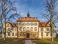
Kleukheim town center
The village ensemble ( location ) comprises the street spaces along the Kellbach and its tributary, the Froschbach with the depth of the adjacent courtyard parcels. The name for Kleukheim, "Clucowa", mentioned for the first time in 1137 in a deed of donation from Bishop Otto of Bamberg to the Michelsberg monastery for the basic equipment of his cell Sankt Getreu, is interpreted as Slavic. Unlike in other cases, the syllable "-heim" cannot be interpreted as one of the numerous Franconian foundations of the region since the second half of the 7th century. Kleukheim was still called “Kliucave” in 1239, the suffix found its way into the place name late, that is, regardless of the founding documents. The quality of the agricultural soils obtained enabled the settlement to grow. In 1625 Kleukheim was ecclesiastically separated from Ebensfeld by the Bamberg prince-bishop Johann Georg Fuchs von Dornheim and raised to an independent parish. After the Thirty Years' War, settlers from the Franconian Forest came to the place, which until the middle of the 20th century served as a large farming village as a center in a small region. Two mills, various craftsmen and several restaurants belonged to the place. Kleukheim has been a district of Ebensfeld since 1978. Within the ensemble, the straight middle section of Kleukheimer Hauptstrasse and Oberküpser Strasse form a distinctive sub-area. On both sides of the Kellbach, which is arranged eccentrically on the south side and is accompanied by a row of small-crowned trees, there are mostly two-storey residential stables and some delivery houses, which on the upper floors often have half-timbering with simple and curved St. Andrew's crosses. As a dominant feature, the Catholic parish church of Sankt Wolfgang with its pointed tower dome dominates the entire ensemble. The square-like situation with the monument erected opposite the church, several characteristic courtyards and the adjoining school square forms the center of the village. The western part of the town along the Froschbach shows a differentiated spatial impression. The defining buildings, residential stalls with half-timbered facades or rear auxiliary buildings are spread across the entire area. Only a few historically significant buildings are located in the side streets of the sub-areas mentioned, for example in Bergstrasse and Obere Mühlstrasse. Traces of historicizing construction methods from the late 19th and early 20th centuries can also be found in the location, for example at Schulplatz, at Steinweg 14 or at Kleukheimer Hauptstraße 38. The conversions of rearward, often higher-lying buildings, especially their roof areas, have an impact increasing the overall impression of the ensemble. File number: E-4-78-120-1.
Architectural monuments according to districts
Ebensfeld
| location | object | description | File no. | image |
|---|---|---|---|---|
| Bahnhofstrasse 18 ( location ) |
Station building | Two-storey sandstone cuboid building with hipped roof, one and a half storey extension to the south with a gable roof ("Bahnwärterkaserne"), 1846 by Eduard Rüber based on plans by Friedrich Bürklein , extension to the north in 1895, extension of the signal box front structure in 1955; In 2015 the building was demolished as part of the expansion of the railway line. | D-4-78-120-1 |
 more pictures |
| Near Bamberger Straße, on the outskirts, southern State Road 2197 ( location ) |
Wayside shrine | Sandstone, wine-entwined column with Corinthian capital, four-sided top with reliefs, inscribed "1711" | D-4-78-120-32 | |
| Dientzenhoferstraße, at the end of the village, northern state road 2197, at the roundabout ( location ) |
Cross tug | Sandstone, inscribed "1812" | D-4-78-120-36 |

|
| Eulengraben, near the A 73, at the fork in the roads to Kutzenberg and Oberleiterbach ( location ) |
Wayside shrine | Sandstone, wine-entwined column with Ionic capital and four-sided top, inscribed "1691" | D-4-78-120-245 | |
| Hauptstrasse 13 ( location ) |
Residential building | Two-story saddle-roof house, hipped on the street side, clad half-timbered upper floor, late 18th / early 19th century | D-4-78-120-3 |

|
| Hauptstrasse 14 ( location ) |
Residential building | Two-story hipped roof house, plastered half-timbered upper floor, late 18th / early 19th century | D-4-78-120-4 |

|
| Hauptstrasse 37 ( location ) |
Residential building | Two-story gable-roof house, hip on the street side, plastered half-timbered upper floor, second half of the 18th century | D-4-78-120-6 |

|
| Hauptstrasse, in front of No. 38 ( location ) |
Sandstone statue of Saint Florian | Marked "1740" | D-4-78-120-7 |

|
| Hauptstrasse 41 ( location ) |
Residential building | Two-storey hipped roof house, half hipped on the street side, partly plastered half-timbered upper floor, corner pilasters on the ground floor, around 1700 | D-4-78-120-8 |

|
| Hauptstrasse 46 ( location ) |
Gasthof zum Schwan | Two-storey eaves hipped roof house with eight axes on the street side, plastered half-timbered upper floor, courtyard entrance, around 1750 | D-4-78-120-9 |

|
| Hauptstrasse 47 ( location ) |
Residential building | Two-storey hipped roof house on the street side with six axes, half-timbered upper floor, sandstone structures on the ground floor, courtyard passage, marked "1712" | D-4-78-120-10 |

|
| Hauptstrasse 49 ( location ) |
Former pharmacy | Two-story saddle-roof house with hipped gable, half-timbered upper floor, early 19th century | D-4-78-120-11 |

|
| Hauptstraße 51, Kirchgasse ( location ) |
Former Neuner brewery | Two-story saddle roof house, hipped on the street side, late 18th century | D-4-78-120-12 |

|
| Hauptstraße 51, Kirchgasse, next to the house ( location ) |
Christ at the pillar of torture | Sandstone, inscribed "1737" | D-4-78-120-12 |

|
| Kirchgasse 1 ( location ) |
Residential building | Two-storey half-timbered house with half-hipped roof, first half of the 19th century, with historical plaster structure, around 1900 | D-4-78-120-201 |

|
| Kirchgasse 2, near Hauptstraße ( location ) |
Residential building | Two-story saddle-roof house, hipped on the street side, plastered half-timbered upper floor, second half of the 18th century | D-4-78-120-14 |
|
| Kirchgasse 2, near Hauptstraße, next to the bridge over the Kellbach ( location ) |
Statue of Saint John Nepomuk | Sandstone, around 1750/60 | D-4-78-120-14 |

|
| Kirchgasse 2 ( location ) |
Gable roof house | Half-timbering in the gable, second half of the 18th century; not re-qualified, see D-4-78-120-14 | D-4-78-120-15 | |
| Kirchgasse 10 ( location ) |
Catholic Parish Church of the Annunciation | 1653/57 over the older core, tower 1696, nave extension 1911–12 by Wilhelm Schmitz, former east choir now nave, west choir with flat dome, tower north of the east choir with hood, with fittings | D-4-78-120-16 |
 more pictures |
| Kirchgasse 10, at the west choir of the parish church ( location ) |
War memorial from 1918 | D-4-78-120-17 |

|
|
| Kirchgasse 13 ( location ) |
Residential building | Two-storey saddle roof house, half-timbered, decorative framework on the gable, middle 17th century | D-4-78-120-18 |

|
| District road LIF 25, on the outskirts, southern state road 2197, at the roundabout ( location ) |
Wayside shrine | Sandstone, column, four-sided attachment with pyramid-shaped end, inscribed "1685" | D-4-78-120-34 |

|
| Mühlgasse 2 ( location ) |
Residential building | Single-storey saddle roof house, half-timbered, second half of the 18th century | D-4-78-120-19 |

|
| Mühlgasse 5 ( location ) |
Residential building | Single-storey gable roof house, street gable hipped, 17th / 18th centuries century | D-4-78-120-20 |

|
| Mühlgasse 7 ( location ) |
Residential building | Single-storey stable house with a high half-hipped roof, still 17th century | D-4-78-120-22 |

|
| Mühlgasse 11 ( location ) |
Mill, courtyard, mill building | One storey, timber-framed 17th century, solid parts probably 19th century | D-4-78-120-23 | |
| Mühlgasse 11 ( location ) |
Mill, courtyard, residential building | Two-storey with half-hipped roof, half-timbered, mid-17th century and 18th-19th centuries. century | D-4-78-120-23 |

|
| Mühlgasse 11 ( location ) |
Mill, yard, barn | Half-hipped roof, half-timbering, mid-17th century, extended 18th century | D-4-78-120-23 | |
| Mühlgasse 11 ( location ) |
Mill, yard, stable | Single-storey half-timbered building, sandstone, 17th century, remodeled around 1900, garden | D-4-78-120-23 | |
| Mühlgasse 11 ( location ) |
Mill, courtyard, garden | D-4-78-120-23 | ||
| Oberbrunner Straße 2 ( location ) |
Residential building | Two-story hipped roof house, plastered half-timbered upper floor, late 18th century | D-4-78-120-24 |

|
| Pferdfelder Weg, approx. 700 m from the town center, northern state road 2197 ( location ) |
crucifix | Sandstone, inscribed "1878" | D-4-78-120-35 | |
| Pferdfelder Weg, 1.4 km northeast of the town center, northern state road 2197 ( location ) |
Wayside shrine | Sandstone, column with a four-sided top, 1693 by Johann Georg Burchart | D-4-78-120-246 |

|
| Prächtinger Strasse 27, Prächtinger Strasse 29, Prächtinger Strasse 31 ( location ) |
graveyard | With grave monuments, layout from 1870 | D-4-78-120-25 | |
| Prächtinger Straße 31 ( location ) |
Cemetery chapel | Neo-Gothic sandstone block building with gable roof and turret, in a niche crucifixion group, 1870, with furnishings | D-4-78-120-26 |
 more pictures |
| Ried, on the field path that branches off from the state road opposite the road to Kutzenberg, southern state road 2197 ( location ) |
Wayside shrine | Sandstone, column with Corinthian capital and four-sided top, inscribed "1711", by Johannes Schwartzmann | D-4-78-120-33 | |
| Sträublingsbach, on Sträublingsbach, approx. 950 m north-northeast of the church, south of State Road 2197 ( location ) |
Two wayside shrines | Sandstone, base, four-sided attachments and Corinthian capital, both by Johannes Schwartzmann in 1710, new column shafts | D-4-78-120-31 | |
| Untere Strasse 8 ( location ) |
Residential building | Single-storey saddle roof house, street gable with crooked hip, half-timbered structure, ornamental framework on the gable, second half of the 18th century | D-4-78-120-27 |

|
| Untere Straße 18 ( location ) |
barn | Half-timbered structure, with a gable roof (rear building) | D-4-78-120-28 |

|
| Untere Strasse 59 ( location ) |
Residential building | Single-storey small house with a gable roof, street gable half-hipped, plastered half-timbering, around 1800 | D-4-78-120-30 |

|
Birkach
| location | object | description | File no. | image |
|---|---|---|---|---|
| Grund, Kreisstraße LIF 25, on the road to Oberbrunn ( location ) |
Wayside shrine | Sandstone, pillar with a Corinthian capital and a four-sided top, mid-18th century | D-4-78-120-42 |

|
| Near Kreuzbachstraße ( location ) |
Catholic branch church of the Immaculate Conception | Neo-Romanesque-Gothic block building with roof turrets, 1857/58, with equipment | D-4-78-120-37 |
 more pictures |
| Kreuzbachstrasse 12 ( location ) |
Residential building | Two-story hipped gable roof house, half-timbered upper floor, corner pilaster on the ground floor, first half of the 18th century | D-4-78-120-38 |

|
| Kreuzbachstraße 19 ( location ) |
Crucifixion group | Sandstone, 1887 | D-4-78-120-39 |

|
| Kreuzbachstrasse 20 ( location ) |
Wayside shrine | Sandstone, square shaft with a Corinthian capital and four-sided top, inscribed "1757" | D-4-78-120-40 |

|
| Mühlleite, approx. 200 m southwest of Kreuzbachstrasse 20 ( location ) |
Picture house | Sandstone, pilaster-framed arched niche, late 18th century | D-4-78-120-41 |

|
Dittersbrunn
| location | object | description | File no. | image |
|---|---|---|---|---|
| Dittersbrunn 7 ( location ) |
Residential stable house | One storey, with a gable roof, front gable half-hipped, half-timbered, early 19th century | D-4-78-120-44 |

|
| Dittersbrunn 12 ( location ) |
Residential building | Single-storey half-timbered house with gable roof, 18th / 19th centuries Century, barn with a gable roof | D-4-78-120-48 |

|
| Dittersbrunn 17 ( location ) |
Housing construction | One-storey, with half-hipped roof, half-timbered structure, gable side covered with slate paintings, probably first half of the 19th century, core dated "1711" | D-4-78-120-45 |

|
| Dittersbrunn 17 ( location ) |
barn | Half-timbered building with stable part, 18./19. century | D-4-78-120-45 |

|
| Dittersbrunn 18 ( location ) |
barn | Half-timbered building with a gable roof, 18th century | D-4-78-120-46 | |
| Near Dittersbrunn, Veitsberg, on the Ansberg ( location ) |
Catholic branch and pilgrimage church Sankt Veit | Three-axis nave, slightly retracted choir, sandstone block construction with roof turret, 1717–19 by Andreas Rheinthaler over the older core ( Ansberg castle stables ), with furnishings, with a “linden wreath” around the chapel (21 trees), the oldest closed linden wreath in Europe | D-4-78-120-49 |
 more pictures |
| In Dittersbrunn ( location ) |
Pull-out house | Single-storey half-timbered house with a gable roof, late 18th century | D-4-78-120-47 |

|
Döringstadt
| location | object | description | File no. | image |
|---|---|---|---|---|
| Bernhardsgraben ( location ) |
Two-bay bridge over the Bernhardsgraben | Sandstone cuboid, mid-19th century | D-4-78-120-205 |
 more pictures |
| Bischof-Senger-Strasse 14 ( location ) |
Residential stable house | One storey, with hipped gable roof, half-timbered, inscribed "1848" | D-4-78-120-53 |

|
| Before Bischof-Senger-Straße 15 ( location ) |
Fountain | Sandstone, round bellied fountain trough, with two pillars and a tent roof above, inscribed "1742" | D-4-78-120-54 |

|
| Bischof-Senger-Straße 18 ( location ) |
Senger brewery inn | Two-storey hipped roof house, half-timbered upper floor with ornamental framework, early 18th century | D-4-78-120-52 |

|
| Bischof-Senger-Straße 18 ( location ) |
Brewery | Two-storey half-hipped roof building, sandstone cuboids and half-timbering, early 19th century | D-4-78-120-52 |

|
| Bischof-Senger-Strasse 19 ( location ) |
Residential stable house | Two-storey, with knee-high and saddle roof, visible framework with St. Andrew's crosses, fretwork on the gable, outside staircase, house Madonna with glass shrine, around 1900 | D-4-78-120-55 |

|
| Bischof-Senger-Strasse 23 ( location ) |
crucifix | Sandstone, black glass plate on the base, inscribed "1905" | D-4-78-120-56 |

|
| Bischof-Senger-Strasse 24 ( location ) |
Residential stable house | One-storey, with a hipped gable roof, half-timbered, first half of the 19th century | D-4-78-120-51 |

|
| Bischof-Senger-Strasse 30 ( location ) |
Former restaurant at the Jägersruh | Two-story hipped roof house, plastered half-timbered upper floor, second half of the 18th century | D-4-78-120-50 |

|
| Bischof-Senger-Strasse 46 ( location ) |
Residential stable house | One storey, with half-hipped roof, sandstone cuboid, 1850/60 | D-4-78-120-59 |

|
| Brunnenplatz ( location ) |
Fountain | Sandstone, round bellied well trough, with two pillars and a gable roof above, inscribed "1753" | D-4-78-120-231 |

|
| Evil Peunt, in the Froschleite corridor ( location ) |
Wayside shrine | Sandstone, column with Ionic capital and four-sided top, first quarter of the 18th century | D-4-78-120-67 |

|
| Brunnenplatz 12 ( location ) |
Wayside shrine | Sandstone, column with Corinthian capital and four-sided top, inscribed "1726" | D-4-78-120-58 |

|
| Near Bgm.-Meixner-Straße ( location ) |
Brewery | Two-storey half-hipped roof building, half-timbered upper floor, labeled "1813" | D-4-78-120-60 |

|
| Draisdorfer Weg, on Döringstädter Berg ( location ) |
Wayside shrine | Sandstone, octagonal pillar with a four-sided top, inscribed "1614" | D-4-78-120-65 |

|
| Geyersberg 5 ( location ) |
Residential stable house | One storey, with a gable roof, half-timbered, around 1900 | D-4-78-120-61 | |
| Grudge, on the dirt road to Emmersberg ( location ) |
Wayside shrine | Sandstone, column with a four-sided attachment with a tent roof, around 1700 | D-4-78-120-66 |

|
| Haigerten, on the road to Ebensfeld ( location ) |
Field chapel | Sandstone block building with a gable roof, mid 19th century, with furnishings | D-4-78-120-70 |

|
| Kirchleite, vineyards, in the Schnelzgalgen corridor ( location ) |
Wayside shrine | Sandstone, column with four-sided attachment, shaft section with fluting 15./16. Century, smooth shaft and attachment 17th century | D-4-78-120-69 |

|
| Melm, on the Döringstädter Berg ( location ) |
Field chapel | Sandstone block construction with a gable roof, 1852 | D-4-78-120-68 |

|
| Vogteistraße 1 ( location ) |
Former district office building | Two-storey plastered hipped roof house, plastered half-timbered upper floor, grooved corner pilasters on the ground floor, 1732 over core of the 16th / 17th century. Century | D-4-78-120-62 |

|
| Vogteistraße 6 ( location ) |
Residential building | Two-story saddle roof building with gable, sandstone structures, around 1895 | D-4-78-120-202 | |
| Vogteistraße 6 ( location ) |
barn | Half-timbered building with a gable roof, 18th century | D-4-78-120-202 | |
| Vogteistraße 7 ( location ) |
Catholic parish church of Saint Martin | Choir tower, choir tower, first half of the 15th century, nave by Joseph Greising , 1715/16 over the older core, with furnishings | D-4-78-120-64 |
 more pictures |
| Vogteistraße 7 ( location ) |
Cemetery wall | Medieval, sandstone relief in a wall niche, probably first half of the 15th century | D-4-78-120-64 |

|
| Vogteistraße 9 ( location ) |
Former school house | Two-story hipped roof building, sandstone structures, around 1800 | D-4-78-120-203 |

|
| Vogteistraße 11, near Vogteistraße ( location ) |
Catholic rectory | Two-story plastered hipped roof house with three to five axes, 1781 | D-4-78-120-63 |

|
| Vogteistraße 11, near Vogteistraße, on Bernhardsgraben ( location ) |
Sandstone statue of John of Nepomuk | Around 1760/70, probably the workshop of Johann Bernhard Kamm | D-4-78-120-63 |

|
| Near Vogteistraße, between Vogteistraße and northern Etterweg ( location ) |
Sandstone slab path | 19th century | D-4-78-120-204 | |
| Near Vogteistraße, behind the church ( location ) |
War memorial | Sandstone crucifix in the shape of an apsidium, inscribed "1864", later expanded to become a war memorial for 1914/18 and 1939/45 | D-4-78-120-206 |

|
Draisdorf
| location | object | description | File no. | image |
|---|---|---|---|---|
| Eierbergweg 1 ( location ) |
Residential building | Two-storey half-hipped roof house, slated half-timbering, 1850 | D-4-78-120-71 |

|
| Zur Linde 3 ( location ) |
Residential stable house | One storey, with a gable roof, half-timbering, sandstone cuboid, 18th century | D-4-78-120-73 |

|
Eggenbach
| location | object | description | File no. | image |
|---|---|---|---|---|
| Eggenbacher Hauptstraße 9 ( location ) |
Residential building | Two-storey farmhouse with hipped roof, half-timbering, arbor, late 17th / early 18th century | D-4-78-120-74 |

|
| Eggenbacher Hauptstraße 17 ( location ) |
Residential building | Two-storey half-hipped roof house, half-timbered, late 18th century | D-4-78-120-75 |

|
| Eggenbacher Hauptstraße 19 ( location ) |
Farmhouse | Two-storey half-hipped roof house, plastered half-timbering, upper storey slated on the west side, late 18th / early 19th century, sandstone barn with saddle roof | D-4-78-120-76 |

|
| Eggenbacher Hauptstraße 21 ( location ) |
Residential stable house | Two-storey, with a gable roof, half-timbering, second half of the 18th century | D-4-78-120-77 |

|
| Eggenbacher Hauptstraße 22 ( location ) |
Residential stable house | One-storey, with a half-hipped roof, plastered half-timbering, barn made of sandstone blocks, mid-19th century | D-4-78-120-80 |

|
| In Eggenbach ( location ) |
Residential stable house | One storey, with a half-hipped roof, half-timbered, inscribed "1847", the ground floor partially changed | D-4-78-120-78 | |
| Hochstätte, near the road to Döringstadt ( location ) |
Wayside shrine | Sandstone, on a square base pillar with a four-sided attachment, inscribed "1718" | D-4-78-120-86 |

|
| Kapellenäcker, south of the church ( location ) |
Wayside shrine | Sandstone, column with Ionic capital, rectangular top with a curved tail, first quarter of the 18th century | D-4-78-120-85 |

|
| Near Klingenweg ( location ) |
Catholic curate and pilgrimage church to Our Lady of Sorrows | Plastered building with sandstone structures, roof turrets, two-tiered choir 1709, nave 1730 by Johann Georg Salb, with furnishings | D-4-78-120-84 |
 more pictures |
| Merkendorfer Straße 1 ( location ) |
Residential stable house | Stilted, single storey, with a gable roof, slated, open staircase, mid-19th century | D-4-78-120-207 |

|
| Merkendorfer Straße 3 ( location ) |
Residential building | Single-storey farmhouse with half-hipped roof, half-timbering, arbor, first half of the 19th century | D-4-78-120-81 | |
| Merkendorfer Straße 5 ( location ) |
Residential stable house | One storey, with a half-hipped roof, half-timbered, 19th century | D-4-78-120-82 | |
| Merkendorfer Straße 9 ( location ) |
Residential building | Single-storey farmhouse with half-hipped roof, half-timbering, entrance arbor, mid-19th century | D-4-78-120-83 |
Erlhof
| location | object | description | File no. | image |
|---|---|---|---|---|
| Erlhof 6 ( location ) |
Residential stable house | Two-storey, with a half-hipped roof, half-timbering, second quarter of the 18th century | D-4-78-120-87 |

|
| Schrotholz, im Breitenloh ( location ) |
Cross stone | Sandstone, late medieval | D-4-78-120-88 |
Freiberg
| location | object | description | File no. | image |
|---|---|---|---|---|
| Freiberg 4 ( location ) |
Residential building | Single-storey farmhouse with half-hipped roof, half-timbered with slate, inscribed "1796" | D-4-78-120-89 |

|
| Freiberg 14, between house numbers 14 and 16 ( location ) |
Village fountain | Shaft surround in sandstone, above half-timbered house with hipped roof, shaft surround from the late 18th / early 19th century, half-timbered house probably from the second half of the 19th century | D-4-78-120-90 |

|
Hahnhof
| location | object | description | File no. | image |
|---|---|---|---|---|
| Hanstrasse 30 ( location ) |
Catholic Parish and Pilgrimage Church of the Immaculate Conception | 1713/14 or 1765/67 over the older core, second construction phase under Johann Thomas Nißler, sandstone block construction, slightly recessed choir, tower with curved twin dome, with furnishings | D-4-78-120-92 |
 more pictures |
| Hanstrasse 31 ( location ) |
farm | Main building, two-storey hipped roof house, second half of the 19th century | D-4-78-120-91 | |
| Hanstrasse 31 ( location ) |
farm | Stables and barn, half-timbered building with a gable roof, 19./20. Century over older parts | D-4-78-120-91 |

|
Kleukheim
| location | object | description | File no. | image |
|---|---|---|---|---|
| Am Froschbach 17 ( location ) |
Residential stable house | One storey, with a half-hipped roof, corner pilasters, drilled sandstone frames, mid-18th century | D-4-78-120-209 |

|
| Bergstrasse 6 ( location ) |
Residential stable house | Two-storey, with a gable roof, ornamental framework, slated gable, first half of the 18th century | D-4-78-120-93 |

|
| Fröschbach, in Kirchstrasse ( location ) |
Wayside chapel | Plastered gable roof building, marked 1881, with picture niche and figure of a saint | D-4-78-120-240 |

|
| Kirchstrasse 2 ( location ) |
Catholic parish church Sankt Wolfgang | Hall with strongly drawn-in choir, tower with pointed helmet and watch tower, choir and tower 1625–26 by Giovanni Bonalino , redesigned by Konrad Fink 1745–47, with furnishings | D-4-78-120-108 |
 more pictures |
| Kirchstrasse 4 ( location ) |
Rectory | Two-story stone building with a hipped roof, 17th century, changes in the 18th and early 19th centuries | D-4-78-120-211 |

|
| Kleukheimer Hauptstrasse 14 ( location ) |
Residential stable house | Two-storey, with hipped roof, half-timbered upper storey, ground floor with corner pilasters, first half of the 19th century | D-4-78-120-96 |

|
| Kleukheimer Hauptstraße 18 ( location ) |
Residential building | Two-storey farmhouse with a gable roof and a dwarf house, a gable with a crooked hip, half-timbered upper floor, corner pilasters made of sandstone on the ground floor, 18th / 19th centuries. century | D-4-78-120-97 |

|
| Kleukheimer Hauptstrasse 20 ( location ) |
Residential and commercial building | Two-storey hipped roof building, sandstone structures, modified on the ground floor, mid-19th century | D-4-78-120-98 |

|
| Kleukheimer Hauptstraße 22 ( location ) |
Residential stable house | One storey, with half-hipped roof, gable framework, 18th century, ground floor renewed around 1840 | D-4-78-120-210 |

|
| Kleukheimer Hauptstraße 24 ( location ) |
Residential building | Two-story hipped roof house, half-timbered upper floor, corner pilasters on the ground floor, inscribed "1825" | D-4-78-120-99 |

|
| Kleukheimer Hauptstrasse 25 ( location ) |
Residential stable house | Two-storey, with a gable roof, front gable half-hipped, half-timbered upper floor, corner pilasters on the ground floor, late 17th / early 18th century | D-4-78-120-100 |

|
| Kleukheimer Hauptstraße 26 ( location ) |
Residential building | Two-story hipped roof house, sandstone structures on the ground floor, ornamental framework on the upper floor, late 17th / early 18th century | D-4-78-120-101 |

|
| Kleukheimer Hauptstrasse 27 ( location ) |
Residential building | Two-storey building on the eaves, probably mostly massive, hipped roof with a large overhang, wooden ornamental shapes in the eaves and the corner formations of the upper floor, first half of the 18th century, baroque stucco ceiling on the upper floor, house Madonna | D-4-78-120-249 |

|
| Kleukheimer Hauptstrasse 29 ( location ) |
Residential building | Two-story hipped roof house with ornamental framework on the upper floor, early 18th century | D-4-78-120-102 |

|
| Kleukheimer Hauptstrasse 43 ( location ) |
Residential stable house | One storey, with a half-hipped roof, half-timbering, second half of the 18th century | D-4-78-120-104 |

|
| Kleukheimer Hauptstraße 47 ( location ) |
Residential stable house | Two-storey, with hipped roof, on the upper storey ornamental framework, early 18th century, ground floor changed | D-4-78-120-106 |

|
| Kleukheimer Hauptstrasse 49 ( location ) |
Residential building | One storey, with a gable roof, one gable half hipped, corner pilaster, 19th century, raised by jamb in the 20th century | D-4-78-120-107 |

|
| Kleukheimer Hauptstrasse 51 ( location ) |
crucifix | Sandstone, inscribed "1733" | D-4-78-120-238 |

|
| Near Kleukheimer Hauptstraße, opposite the church ( location ) |
War memorial for 1914-1918 and 1939-1945 | Sandstone, rectangular base with column and statue of the Virgin Mary | D-4-78-120-239 |

|
| Oberküpser Straße 4 ( location ) |
Residential building | Single-storey gable roof house, half-timbered, first half of the 19th century | D-4-78-120-110 |

|
| Schulplatz 1 ( location ) |
Residential building | Two-storey half-timbered building with a gable roof, slated gable, first half of the 19th century | D-4-78-120-114 |

|
| School place 2 ( location ) |
Residential building | Single-storey saddle roof house with ornamental framework, first half of the 19th century | D-4-78-120-115 |

|
| School place 4 ( location ) |
Residential building | Two-story hipped roof building, 1836 | D-4-78-120-116 |

|
| Steinweg 8 ( location ) |
Farmhouse | Two-story hipped roof house, ornamental framework on the upper floor, early 18th century | D-4-78-120-113 |

|
| Steinbühl ( location ) |
Holy House | Stele with attachment, picture niche with iron grating, inscribed "MK 1743" | D-4-78-120-237 |

|
Caraway seed
| location | object | description | File no. | image |
|---|---|---|---|---|
| Brunnwiesen, at the northern exit of the village, at the fork in the road behind Rödeslgasse 8 ( location ) |
Wayside shrine | Sandstone column with a four-sided attachment, by Johann Georg Burckhart around 1720 | D-4-78-120-123 |

|
| Am Kümmelbach 10 ( location ) |
Residential stable house | Two-storey, with a gable roof, clad half-timbered upper storey, corner pilaster on the ground floor, early 19th century | D-4-78-120-121 |

|
| Am Kümmelbach 20 ( location ) |
Residential stable house | One storey, with a gable roof, half-timbered gable, corner pilaster strips on the ground floor, second half of the 19th century | D-4-78-120-119 |

|
| Am Kümmelbach 22 ( location ) |
Residential stable house | One storey, with a gable roof, half-timbered gable, corner pilaster on the ground floor, second half of the 19th century | D-4-78-120-118 |

|
Kutzenberg
District Hospital Obermain
Former Upper Franconian sanatorium and nursing home ( location ). Extensive overall arrangement in the pavilion system in park-like grounds in the forms of the Baroque historicism and the historicizing Heimat style, often with half-timbering, 1904-08 according to plans by Spieß and 1910-16 according to plans by G. Frey, accessed via a lime tree avenue from the original complex receive. File number: D-4-78-120-212. The individual sub-objects are as follows.
- Ward building: Diagnostics and Therapy Center, 1913, rebuilt in 1995 (House No. 4)
- Nursing home, 1914, rebuilt in 2001 (house no.5)
- Acute psychiatry, 1914, rebuilt 1962 and 1987 (house no.6)
- Nursing home, 1906, rebuilt in 1974 and 1994 (house no.7)
- Sisters of the Order, 1906 (House No. 8)
- Day clinic, 1906, rebuilt in 1976 and 2000 (house no.10)
- Nursing school, 1906, rebuilt in 1980 and 1998 (house no.11)
- Kiosk with bowling alley and wash house, 1908 (house no.17)
- Houses for doctors and nurses: House 18, 1912, renovated in 1972 (house no.18)
- Headquarters and administration building, two or three-story hipped mansard roof building with roof turrets, 1906, rebuilt in 1913 and 1916 (house no.19)
- Ballroom building with church, two-storey hipped mansard roof with roof turret, 1912, rebuilt in 1960 and 1988 (house no.20)
- Outbuildings: kitchen and laundry room, 1906, for diagnostics u. Therapy center rebuilt in 2001 (house no.22)
- Butcher and bakery, 1912, converted into a staff residence in 2001 (house no.24)
- House 25, 1907, renovated in 1993 (house no.25)
- House 26, 1910, renovated in 1996 (house no. 26)
- House 27, 1913, renovated in 1996 (house no.27)
- House 29, 1930, renovated 1963/64 and 1989 (house no.29)
- House 32, 1936 (house no.32)
- Former horse stable, 1914 (house no.33)
- House 38, 1907/12, renovated in 1992 (house no.38)
- Garden pavilion, 1916, renovated in 1999 (without house no.)
- Waterworks on Lindenallee, 1906 (without house no.)
- Former manor complex with residential building, 1912 (house no.131)
- Lindenallee leading from Ebensfeld to the clinic area
Headquarters and administration building (house number 19)

Ballroom building with church (house no.20)
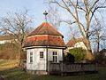
Garden pavilion

Horse stable (house no.33)
Gutshof (house no.131)


Messfeld
| location | object | description | File no. | image |
|---|---|---|---|---|
| Cross, approx. 650 m southwest of the village ( location ) |
Wayside shrine | Sandstone, column with a four-sided top, early 17th century | D-4-78-120-129 |

|
| Messfeld 15 ( location ) |
crucifix | Sandstone, around 1900 | D-4-78-120-124 |

|
| Messfeld 18 ( location ) |
Wayside shrine | Sandstone, column with Corinthian capital, four-sided top, second quarter of the 18th century | D-4-78-120-125 |

|
| From Döringstadt to Messenfeld, at the eastern end of the village ( location ) |
Wayside chapel | Cube-shaped plastered building with tent roof, 18th century, with furnishings | D-4-78-120-128 |

|
Mönchshof
| location | object | description | File no. | image |
|---|---|---|---|---|
| Bernhardsgraben, Kreisstraße LIF 7, on the Döringstadt-Wiesen road ( location ) |
Wayside shrine | Sandstone, column with a four-sided top, mid 17th century | D-4-78-120-131 |

|
| Mönchshof 1 ( location ) |
Former manor of the Langheim monastery | Three-sided system, two-storey stable house with hipped roof, half-timbered upper floor, 18th / 19th century. century | D-4-78-120-130 |

|
Neudorf near Ebensfeld
| location | object | description | File no. | image |
|---|---|---|---|---|
| Am Birkacher Weg ( location ) |
Round arch bridge | Single arch, sandstone, with sandstone abutment, 18th / 19th century century | D-4-78-120-234 | |
| In Neudorf ( location ) |
Catholic chapel Heart of Jesus | Neo-Gothic sandstone block, 1899, with furnishings | D-4-78-120-132 |

|
| Neudorf 3 ( location ) |
Wayside shrine | Sandstone, column with a Corinthian capital, four-sided top, inscribed "1725/1726", by Johann Georg Burchart | D-4-78-120-134 |

|
| Neudorf 14 ( location ) |
Residential building | Two-story farmhouse with hipped roof, plastered half-timbered upper floor, 1851 | D-4-78-120-133 |

|
Niederau
| location | object | description | File no. | image |
|---|---|---|---|---|
| Niederau 5 ( location ) |
Residential stable house | One storey, with a half-hipped roof, half-timbering, late 18th / early 19th century | D-4-78-120-135 |

|
| In Niederau ( location ) |
Village fountain | Round, bulbous sandstone fountain trough, square pillars, on top of a gable roof, inscribed "1699" | D-4-78-120-137 | |
| Deep fields, 400 m east of the village ( location ) |
Wayside shrine | Sandstone, column with four-sided attachment, inscribed "1707" by Johannes Absalon Burckhart | D-4-78-120-136 |

|
| Deep fields, on the road to Untersteuses ( location ) |
crucifix | Sandstone, gothic, with enclosure, inscribed "1896" | D-4-78-120-215 |

|
Oberbrunn
| location | object | description | File no. | image |
|---|---|---|---|---|
| Am Schloßberg 2 ( location ) |
Residential building | Two-storey hipped roof house, plastered half-timbered upper floor, sandstone structures, marked "1855" | D-4-78-120-141 |

|
| Am Schloßberg 3 ( location ) |
Residential stable house | Elongated, two-story, with a gable roof, plastered half-timbered upper floor, inscribed "1819" | D-4-78-120-138 |

|
| Am Schloßberg 3 ( location ) |
Wayside shrine | Sandstone column with a four-sided attachment, inscribed "1711" | D-4-78-120-138 |

|
| Birkacher Straße 2 ( location ) |
Residential building | Two-storey, with a gable roof, sandstone block building with half-timbered upper floor, around 1890, twin building at Birkacher Straße 4 | D-4-78-120-214 |

|
| Birkacher Straße 4 ( location ) |
Residential building | Two-storey, with a gable roof, sandstone block building with half-timbered upper floor, around 1890, twin building to Birkacher Straße 2 | D-4-78-120-213 |

|
| Birkacher Straße 5 ( location ) |
Residential building | Single-storey fracked house with half-timbered upper storey, early 19th century | D-4-78-120-224 |

|
| Hofberglein, approx. 300 m west of the village ( location ) |
Wayside shrine | Sandstone column with a four-sided top, inscribed "1737" | D-4-78-120-144 |

|
| Near Laurenzistraße ( location ) |
Catholic branch church Sankt Laurentius | Hall building with retracted choir and single-tower facade, 1743/50 according to plans by Johann Jakob Michael Küchel , with furnishings | D-4-78-120-142 |
 more pictures |
| Laurenzistraße 3 ( location ) |
Wayside shrine | Sandstone column with a four-sided attachment, marked "1700" | D-4-78-120-143 |

|
| Wiesenweg 8 ( location ) |
farm | Single-storey stable house with saddle roof, mainly half-timbered building, first half of the 19th century,
Half-timbered barn with a gable roof and massive door frame, inscribed "1796" |
D-4-78-120-139 |

|
| Wiesenweg 10 ( location ) |
Residential stable house | One storey, with gable roof, half-timbered, first half of the 19th century, half-timbered barn with gable roof, first half of the 19th century | D-4-78-120-140 |

|
| Ziegelanger 7 ( location ) |
Wayside shrine | Column on pedestal with a four-sided attachment with picture niches and arched shell gables, inscribed "1694" | D-4-78-120-248 |
Oberküps
| location | object | description | File no. | image |
|---|---|---|---|---|
| Wendish, north of the Kellbach ( location ) |
Wayside shrine | With Corinthian capital and essay, first half of the 18th century | D-4-78-120-236 |

|
| Oberküps 14 ( location ) |
Residential stable house | One storey, with a gable roof, half-timbered gable, first half of the 19th century | D-4-78-120-147 |

|
| Oberküps 20 ( location ) |
Residential stable house | Two-storey, with a gable roof, half-timbered upper storey, middle 18th century | D-4-78-120-152 |

|
| Oberküps 29 ( location ) |
Residential stable house | One storey, with a saddle roof, rich ornamental framework, 17th / 18th centuries century | D-4-78-120-151 |

|
| Oberküps 51 ( location ) |
Residential stable house | One storey, with a gable roof, half-timbered gable, first half of the 19th century | D-4-78-120-150 |

|
| Oberküps 53 ( location ) |
Residential stable house | One storey, with a gable roof, half-timbering, second half of the 18th century | D-4-78-120-149 |

|
| In Oberküps ( location ) |
Catholic branch church Sankt Katharina | Single tower facade, nave with retracted choir, 1798-1802 according to plans by Johann Lorenz Fink, with furnishings | D-4-78-120-146 |

|
| In Oberküps, at the entrance to the church ( location ) |
Wayside shrine | Sandstone, column with Ionic capital, four-sided top, around 1700 | D-4-78-120-153 |

|
| Stilleite ( location ) |
Wayside shrine | With Ionic chapter and essay, inscribed "1692" | D-4-78-120-235 |

|
Peusenhof
| location | object | description | File no. | image |
|---|---|---|---|---|
| Peusenhof 1 ( location ) |
Oberhof | Two-storey farmhouse with a gable roof, half-timbered upper floor, slated gable side, corner pilasters on the ground floor, inscribed "1866" | D-4-78-120-155 |

|
| Peusenhof 1 ( location ) |
crucifix | Sandstone, inscribed "1891", in front of house number 1, body worn away | D-4-78-120-159 |

|
| Peusenhof 2 ( location ) |
Manor of the former Benedictine Abbey of St. Michael in Bamberg | Two-storey mansard roof building, plastered half-timbered upper floor, probably 18th century, half-timbered barn, probably 17th century, shepherd's house, early 18th century | D-4-78-120-156 |

|
| Peusenhof 2 ½ ( location ) |
Wayside shrine | Sandstone, column with four-sided attachment, inscribed "1689" | D-4-78-120-158 |

|
| Peusenhof 2 ½ ( location ) |
Residential building | Two-story farmhouse with a gable roof, ground floor made of sandstone blocks, half-timbered upper floor, gable slated, inscribed "1866", Neydecker coat of arms relief on the cellar house, around 1600 | D-4-78-120-157 |

|
Horse field
| location | object | description | File no. | image |
|---|---|---|---|---|
| On the way to Veitsrangen ( location ) |
Wayside shrine | Sandstone, column with four-sided top, inscribed "1693" | D-4-78-120-163 | |
| Horse field 14 ( location ) |
Residential stable house | One storey, with a half-hipped roof, half-timbering, second quarter of the 19th century | D-4-78-120-161 | |
| Horse field 19 ( location ) |
Parish hall | Two-storey hipped roof house with roof turret, half-timbered, early 18th century | D-4-78-120-160 |

|
| Horse field 25 ( location ) |
crucifix | Sandstone, inscribed "1899" | D-4-78-120-242 |

|
| Horse field 51 ( location ) |
crucifix | Sandstone, with a Gothic base, inscribed "1904" | D-4-78-120-217 |

|
| In horse field, at the local chapel ( location ) |
Wayside shrine | Sandstone, column with Corinthian capital, four-sided top, inscribed "1733" | D-4-78-120-162 |

|
| In Horses field, on the outskirts of Untereuses ( location ) |
Wayside shrine | Sandstone, square base, column with Ionic capital, four-sided top, late 17th / early 18th century | D-4-78-120-164 |

|
| Inhorsfeld, in the village, on the road to Staffelstein, on Haselbach ( location ) |
Wayside shrine | Sandstone, square base with column, four-sided top, late 17th / early 18th century | D-4-78-120-167 |

|
| Inhorsfeld, on the road to Staffelstein, at Haselbach ( location ) |
Picture house | Sandstone, square base, building with a round-arched barred niche, early 19th century | D-4-78-120-168 |

|
| In horse field ( location ) |
Wayside shrine | Wayside shrine, sandstone, vine-entwined column with Ionic capital, four-sided top, last quarter of the 17th century, on the outskirts of the village towards Untereuses | D-4-78-120-165 |

|
| From Horsesfeld to Staffelstein, on the road to Staffelstein ( location ) |
Wayside shrine | Sandstone, bulbous square base, column with four-sided top, inscribed "1746" | D-4-78-120-166 |

|
Splendid
| location | object | description | File no. | image |
|---|---|---|---|---|
| Alte Dorfstrasse 6 ( location ) |
Sandstone relief | Coronation of the Virgin Mary, late 18th / early 19th century | D-4-78-120-170 | |
| Alte Dorfstrasse 14 ( location ) |
Residential building | Single-storey half-timbered house with a gable roof, early 19th century | D-4-78-120-169 |

|
| Fire station 1 ( location ) |
Residential building | Single-storey house with fracked roof, half-timbered, inscribed "1832" | D-4-78-120-175 |

|
| Fire station 2 ( location ) |
Residential building | Single-storey gable roof house, corner pilaster, half-timbered gable, second half of the 18th century | D-4-78-120-174 |

|
| Hanstraße, on the road to the Hankirche, below the cemetery ( location ) |
Wayside shrine | Column with a four-sided top, late 17th century | D-4-78-120-178 |

|
| Kehl, approx. 100 m below the church ( location ) |
Cross bearer | Sandstone, inscribed "1720" by Johannes Absalon Burckhart | D-4-78-120-179 |

|
| Staatsstrasse 2187, Wolfsanger, on the road to Ebensfeld, near the Preßlermühle ( location ) |
Wayside shrine | Sandstone, column with Ionic capital, four-sided top, inscribed "1732" | D-4-78-120-177 |

|
| Zeitelbachweg 1 ( location ) |
Residential stable house | Two-storey, with hipped roof, clad half-timbered upper floor, late 18th century | D-4-78-120-176 |

|
Sträublingshof
| location | object | description | File no. | image |
|---|---|---|---|---|
| Peunt, on the "sand hill" ( location ) |
Wayside shrine | Sandstone, column with Ionic capital, four-sided top, inscribed "1712" | D-4-78-120-220 |

|
| Near Schlößleinsweg, at the entrance to the village ( location ) |
Wayside chapel | Small sandstone block building with four-sided hood, inscribed "1849"; with equipment | D-4-78-120-180 |

|
| Sträublingshof 1 ( location ) |
Residential stable house | One storey, with a gable roof, half-timbering, plastered, probably 18th century | D-4-78-120-181 |

|
| Sträublingshof 2 ( location ) |
Residential stable house | Two-storey, with a gable roof, 18th century, renovations from 1923 | D-4-78-120-182 |

|
Unterbrunn
| location | object | description | File no. | image |
|---|---|---|---|---|
| Dorfstraße 8 ( ) |
House figure | Wood, Pietà, 17./18. Century; not re-qualified, not mapped in the Bavarian Monument Atlas | D-4-78-120-187 | |
| Dorfstrasse 12 ( location ) |
barn | Half-timbered structure, with a gable roof, marked "1781" | D-4-78-120-219 | |
| Dorfstrasse 13 ( location ) |
Residential building | Two-storey eaves hipped roof house, sandstone inclusions, early 19th century | D-4-78-120-185 |

|
| Dorfstrasse 21 ( location ) |
Residential stable house | Two-storey, with a gable roof, half-timbered upper floor, mid-19th century, ground floor partially renovated | D-4-78-120-186 |

|
| Near Dorfstrasse ( location ) |
Catholic branch church Maria Himmelfahrt | Sandstone block construction, three-axis nave with retracted choir, west tower, 1872/75, with furnishings | D-4-78-120-183 |

|
| Near Dorfstrasse, between the church and Dorfstrasse 17 ( ) |
Sequence of sandstone monoliths | Probably 19th century; not re-qualified, not mapped in the Bavarian Monument Atlas | D-4-78-120-218 | |
| Graserweg, on the road to Rattelsdorf, at the junction to Unterleiterbach ( location ) |
Wayside shrine | Sandstone, four-sided attachment in the middle of the 18th century, base, shaft and fighter plate renewed | D-4-78-120-241 |

|
| District road LIF 8, on the road to Rattelsdorf ( location ) |
crucifix | Wood, 1913 | D-4-78-120-188 |

|
| Leiten, on the road to Rattelsdorf, 200 m south of the outskirts ( location ) |
Wayside shrine | Sandstone, square base, column with Corinthian capital, four-sided top, inscribed "1726" by Johannes Absalon Burckhart | D-4-78-120-189 |

|
Accommodations
| location | object | description | File no. | image |
|---|---|---|---|---|
| Au, on the way to Vorderen Reut ( location ) |
Field chapel | Sandstone block building with a gable roof, mid 19th century, with furnishings | D-4-78-120-193 |

|
| Au, approx. 400 m from the western edge of the village, on the dirt road to Vorderen Reut ( location ) |
Wayside shrine | Sandstone, winding column entwined with wine, four-sided top, around 1690 | D-4-78-120-195 |

|
| Au, on the western outskirts ( location ) |
Wayside shrine | Sandstone, column with Ionic capital, four-sided top, around 1710/20 | D-4-78-120-194 |

|
| Auäcker, on the way to Roschlaub ( location ) |
Wayside shrine | Sandstone, column with Ionic capital, four-sided top, inscribed "1715", by Johannes Absalon Burckhart | D-4-78-120-196 |

|
| Sub-section 5 ( location ) |
Former inn | Two-storey saddle-roofed house, in the west with a hip, half-timbered upper storey, early 18th century | D-4-78-120-191 | |
| Unterüps 6 ( location ) |
Residential stable house | One storey, with a gable roof, half-timbered gable, early 19th century | D-4-78-120-192 |

|
Corporate
| location | object | description | File no. | image |
|---|---|---|---|---|
| Glesengasse, at the junction Glesengasse / Haselbachstraße ( location ) |
crucifix | Sandstone, inscribed "1827" | D-4-78-120-244 |

|
| Haselbachstrasse 6 ( location ) |
Residential stable house | Two-storey, with a half-hipped roof, half-timbering, early 19th century | D-4-78-120-198 | |
| Near Haselbachstraße ( location ) |
Residential stable house | One storey, with a gable roof, front gable with half-hip, half-timbering, late 18th century | D-4-78-120-199 |

|
| Melm, on Staatsstrasse 2197 to Staffelstein ( location ) |
Wayside shrine | Sandstone, column with Corinthian capital, four-sided top, around 1700 | D-4-78-120-200 | |
| Pferdfelder Straße 1 ( location ) |
Outbuildings | With a gable roof, sandstone cuboid and half-timbering | D-4-78-120-221 |

|
| Pferdfelder Straße 1 ( location ) |
Arched niche | With crucifix, late 19th century (crucifix marked "1899") | D-4-78-120-221 |

|
| Pferdfelder Straße 10 ( location ) |
Catholic Chapel Immaculate Heart of Mary | Neo-Gothic, extended in 1904, 1966, equipment from the construction period | D-4-78-120-222 |

|
Former architectural monuments according to districts
Ebensfeld
| location | object | description | File no. | image |
|---|---|---|---|---|
| Friedenslinde 4 ( location ) |
Gable roof house | One storey, 18./19. century | D-4-78-120-2 | |
| Hauptstrasse 24 ( location ) |
Half-timbered house | Late 17th century | D-4-78-120-5 | |
| Hauptstrasse 52 ( location ) |
Kriebel's restaurant | Half hipped roof house, first half of the 18th century | D-4-78-120-13 |
Birkach
| location | object | description | File no. | image |
|---|---|---|---|---|
| 300 m south of the outskirts ( ) |
Wayside shrine | Probably the 18th century | D-4-78-120-43 |
Döringstadt
| location | object | description | File no. | image |
|---|---|---|---|---|
| Bischof-Senger-Strasse 25 ( location ) |
Residential stable | One storey, half-timbered house, early 19th century | D-4-78-120-57 |
Draisdorf
| location | object | description | File no. | image |
|---|---|---|---|---|
| Eierbergweg 2 ( ) |
Half hipped roof house | Mid 19th century | D-4-78-120-72 |
Eggenbach
| location | object | description | File no. | image |
|---|---|---|---|---|
| Eggenbacher Hauptstraße 29 ( location ) |
Half hipped roof house | One storey, first half of the 19th century | D-4-78-120-79 |
Kutzenberg
| location | object | description | File no. | image |
|---|---|---|---|---|
| West of the manor ( ) |
Wayside shrine | Sandstone, around 1710 | D-4-78-120-223 |
Caraway seed
| location | object | description | File no. | image |
|---|---|---|---|---|
| Am Kümmelbach 16 ( location ) |
Residential stable house | Half-timbered, early 19th century | D-4-78-120-120 | |
| Am Kümmelbach 19 ( location ) |
Eaves side house | Early 19th century | D-4-78-120-122 |
Kleukheim
| location | object | description | File no. | image |
|---|---|---|---|---|
| Am Froschbach 7 ( location ) |
Small house | With half-hipped roof, half-timbering, early 19th century | D-4-78-120-208 | |
| Bergstraße 8 ( ) |
Half hipped roof house | With ornamental framework, first half of the 19th century | D-4-78-120-94 | |
| Gartenstraße 13 ( ) |
Residential stable house | First half of the 19th century | D-4-78-120-95 | |
| Hauptstraße 39 ( ) |
Sandstone relief | 18./19. century | D-4-78-120-103 | |
| Oberküpser Straße 1 ( location ) |
Residential stable house | First half of the 19th century | D-4-78-120-109 | |
| Oberküpser Straße 9 ( location ) |
Half-timbered house | With a gable roof, first half of the 19th century | D-4-78-120-111 |

|
| Steinweg 7 ( location ) |
Half-timbered construction | Mid 19th century | D-4-78-120-112 |
Messfeld
| location | object | description | File no. | image |
|---|---|---|---|---|
| House number 7 ( ) |
Half-timbered house | One storey, first half of the 19th century | D-4-78-120-126 |
Oberküps
| location | object | description | File no. | image |
|---|---|---|---|---|
| Oberküps 10 ( location ) |
Residential stable house | With half-timbered gable, middle 18th century | D-4-78-120-148 |
Horse field
| location | object | description | File no. | image |
|---|---|---|---|---|
| On the road to Staffelstein ( ) |
Summer cellar | Basement made of sandstone blocks with a pair of linden trees, first half of the 19th century | D-4-78-120-216 |

|
Splendid
| location | object | description | File no. | image |
|---|---|---|---|---|
| Berg, near the casting hill on the formerly Hohen Strasse ( location ) |
Cross stone | Medieval | D-4-78-120-263 | |
| Holzweg 2 ( location ) |
Former school house | Two-storey hipped roof house with ridge turret, half-timbered upper floor, sandstone structures, 1823 over an older core | D-4-78-120-243 |

|
| Marienweg 1 ( location ) |
Half-timbered house | One storey, mid 19th century | D-4-78-120-173 |
Unterbrunn
| location | object | description | File no. | image |
|---|---|---|---|---|
| Approx. 200 m northwest of the cemetery ( ) |
Torture | Square base, early 18th century | D-4-78-120-190 |
Accommodations
| location | object | description | File no. | image |
|---|---|---|---|---|
| North of the Kellbach ( ) |
Torture | Sandstone column, first half of the 18th century | D-4-78-120-197 |
See also
Remarks
- ↑ This list may not correspond to the current status of the official list of monuments. The latter can be viewed on the Internet as a PDF using the link given under web links and is also mapped in the Bavarian Monument Atlas . Even these representations, although they are updated daily by the Bavarian State Office for Monument Preservation , do not always and everywhere reflect the current status. Therefore, the presence or absence of an object in this list or in the Bavarian Monument Atlas does not guarantee that it is currently a registered monument or not. The Bavarian List of Monuments is also an information directory. The property of a monument - and thus the legal protection - is defined in Art. 1 of the Bavarian Monument Protection Act (BayDSchG) and does not depend on the mapping in the Monument Atlas and the entry in the Bavarian Monument List. Objects that are not listed in the Bavarian Monument List can also be monuments if they meet the criteria according to Art. 1 BayDSchG. Early involvement of the Bavarian State Office for Monument Preservation according to Art. 6 BayDSchG is therefore necessary in all projects.
literature
- Denis André Chevalley: Upper Franconia . Ed .: Michael Petzet , Bavarian State Office for the Preservation of Monuments (= Monuments in Bavaria . Volume IV ). Oldenbourg, Munich 1986, ISBN 3-486-52395-3 .
Web links
- Bavarian Monument Atlas (cartographic representation of the Bavarian architectural and ground monuments by the Bavarian State Office for Monument Preservation (BLfD) )
- List of monuments for Ebensfeld (PDF) at the Bavarian State Office for Monument Preservation
