Königstuhl (Odenwald)


- Heidelberg television tower (left)
- Heidelberg telecommunications tower (right)
- Berghotel and Restaurant Königstuhl
- mountain station of the Heidelberg mountain railway


The Königstuhl in the city of Heidelberg and in the Rhein-Neckar district in Baden-Württemberg is 570.3 m above sea level. NHN the highest mountain both in the Kleiner Odenwald and on the Bergstrasse . He and the Heiligenberg ( 439.9 m ) are Heidelberg's two local mountains ; between the two, the Neckar flows from the Odenwald-Neckar Valley and at the same time from the Neckartal-Odenwald Nature Park into the Upper Rhine Plain to the west . The mountain is known nationwide above all for the Heidelberg Castle standing on a lower slope and the Heidelberg mountain railway , which leads from Heidelberg's old town in the Neckar Valley to its summit region.
geography
location
The Königstuhl is located in the west of the Neckartal-Odenwald Nature Park . According to Section 35 of the Building Code, it is located outside and, administratively, belongs to the area of the Heidelberg Old Town , the built-up area of which extends at the northwestern foot of the wooded mountain. The extensive mountain range, stretching from north to south over several kilometers, is clearly delimited on three sides, in the west by the slope to the flat Upper Rhine Plain , in the north and northeast by the sharp valley cut of the Neckar and in the southeast by the somewhat smaller Elsenz ; the only slight drop to the south makes the transition into the hilly landscape of the Kraichgau smooth.
The Königstuhl is bordered by the following localities, many of which have shares in it ( clockwise ; starting in the southwest): the city of Heidelberg with the districts of Emmertsgrund and Boxberg (southwest), Rohrbach (west-southwest), Weststadt (west), old town ( Northwest) and Schlierbach (north to northeast), the city of Neckargemünd (east) with its district Waldhilsbach (southeast), the communities of Gaiberg and Bammental (south-southeast), the Leimen district of Lingental (south), the core town of Leimen and the community of Nussloch ( South southwest). On the mountain massif, a little south of its summit, is the Kohlhof settlement belonging to Heidelberg's old town . In the area of its southern foothills lie the villages of Gauangelloch and Ochsenbach , which belong to Leimen, and Maisbach, which belongs to Nussloch .
The Kümmelbach rises in the east of the massif , the Hilsbach in the southeast , the Weihwiesenbach further south and the Gauangelbach in its southern foothills .
About 3 km northwest of the mountain peak rises beyond the Neckar in the local Odenwald the Heiligenberg ( 439.9 m ).
Natural allocation
The Königstuhl massif belongs to the natural spatial main unit group Odenwald, Spessart and Südrhön (No. 14) and in the main unit Sandstein-Odenwald (144) to the subunit Western Kleiner Odenwald (144.1), to which the subunit Odenwald-Neckar Valley (144.3 ) connects. To the southeast, the main unit group Kraichgau (12) borders the natural areas Schwarzbachgäu (125.17) and Angelbachgäu (125.18). Directly to the west is the main unit Bergstrasse (226) with the sub-unit Gaisbergfuß (226.1), which connects to the main unit group Northern Upper Rhine Lowland (22) to the west .
Geology and red sandstone as building material
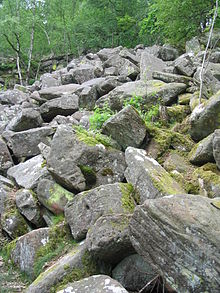
In the Königstuhl massif, south of the Neckar, there are thick layers of red sandstone . In thawing phases at the end of the Ice Age, rocks made of this rock slid downwards on permafrost soils and formed two larger and preserved rock heaps on the northern slopes of the massive mountains in the transition area to the Auerhahnenkopf ( 486.9 m ) above Schlierbach , the Königstuhl rock seas , the eastern one at around 270 to 410 m and the western one at around 340 to 480 m height.
Small amounts of sandstone were extracted from the slopes of the mountain range in quarries, at the Molkenkur in today's Teufelsloch and at the Riesenstein . The red sandstone does not only show itself on steep slopes in the landscape that open up the banks, but it also shapes the regional architecture. The historical buildings built from the Neckar valley sandstone in the surrounding villages , the most famous of which is probably the Heidelberg Castle , show the characteristic red color of the stone.
history
Protected areas
Two of three parts of the Felsenmeer, Russenstein and Michelsbrunnen nature reserve ( CDDA no. 82209; designated 1956; 9 hectares in size) are located a little to the east and south-east of Königstuhl . Parts of the landscape protection area (LSG) Neckartal I, Kleiner Odenwald (CDDA no. 323144; 2002; 63.25 km² ) are located in the south -eastern foothills of the mountain range and parts of the LSG Bergstrasse-Süd (CDDA no. 344853; 2005 ) are in the southern foothills ; 27.16 km²). Areas of the fauna-flora-habitat area Kleiner Odenwald (FFH no. 6618-341; 35.6 km²) are located on large parts of the massif .
Mountain tops, mountain flanks and facilities
Main crest
On the main dome with the peak ( 567.8 m ) of the king chair are among others - with height in meters (m) above mean sea level (MSL):
- Radio, television and directional radio transmission systems (including the year of construction / period, building and location height):
-
TV tower Heidelberg of the Südwestrundfunk
(1958, 82 m, approx. 561 m above sea level ); served as an observation tower until 2002 (platform height 30 m), -
Telecommunications tower Heidelberg of Deutsche Telekom
(1958, 102 m, approx. 566 m above sea level ) -
Former US Army telecommunications tower
(late 1950s, approx. 562 m above sea level ); In 2007 returned by the United States Army to the state of Baden-Württemberg, microwave systems out of order, it was converted to fiber optics
-
TV tower Heidelberg of the Südwestrundfunk
- Märchenparadies Königstuhl (approx. 560 to 565 m )
- Berghotel and Restaurant Königstuhl (approx. 552 m )
- Falconry Tinnunculus (approx. 552 m )
South southwest tip
On the nameless south-south-west summit of the Königstuhl ( 564.4 m ), near the Plättleshöhe ( 545.1 m ), are:
- Max Planck Institute for Astronomy (MPIA) with House of Astronomy (approx. 555 m each )
- State Observatory Heidelberg-Königstuhl (approx. 560 m )
Flanks of the mountain range
On the massive flanks are among other things ( counterclockwise ):
- Königstuhl rock seas (eastern part, approx. 270 to 410 m ; western part, approx. 340 to 480 m ) made of red sandstone block heaps, on the northern slope and in the transition area to the Auerhahnenkopf
- Teufelskanzel (approx. 180 m ), sandstone rocks in the Neckar Valley, near Schlierbach , north flank / foot
- Carl Bosch Museum Heidelberg (approx. 215 m ), in the Neckar Valley, in Schlierbach, north flank
- Heidelberg Castle with Hortus Palatinus Castle Garden (garden location: at 196 m ), northwest flank
- Himmelsleiter (stairs made of 1200 sandstone steps), northwest flank, between the castle and the summit region
- Heidelberger Bergbahn (113.2 to 549.8 m ), funicular, northwest flank and summit region
- Molkenkur (former health resort; former location of the castle in the mountains ; with the Molkenkur cable car station , 289.3 m ), northwest flank
- Arboretum I at the Sprunghöhe , park with a selected population of different tree and shrub species (including a sequoia tree ), western flank
- Klink Schmieder , Speyererhof (approx. 290 to 310 m ), west flank
- Arboretum II at Speyererhofpark , planting of exotic trees (foreign lands) , established in the last quarter of the 19th century , western flank
- Max Planck Institute for Nuclear Physics (MPIK) (approx. 290 to 320 m ), southwest flank
- Bierhelderhof ( 260 m ), old farmstead and today's Gutsschänke, southwest flank
- Forest pirate camp of the German Children's Cancer Foundation (approx. 270 to 75 m ), southwest flank
- European Molecular Biology Laboratory (EMBL) (approx. 280 to 320 m ), southwest flank
- Kohlhof (approx. 435 to 450 m ), settlement with Posseltslust observation tower (Kohlhof) , south flank
- Rehabilitation Clinic Heidelberg-Königstuhl (approx. 450 to 480 m ), south flank
Minor peaks
1.8 kilometers west of the Königstuhl summit is the 375.6 m high Gaisberg ( Geißberg ) with the approximately 13 m high Gaisbergturm observation tower (approx. 360 m ). As Vorberg it is on a in connection with the grave breach Upper Rhine Valley sunken tectonic plaice, the fault line runs through the 348.4 m high and senior king chair saddle jump height with dortiger refuge jump height hut . Below the Gaisberg is the giant stone with a viewing pulpit (approx. 225 m ).
2.2 km east of the main summit, south of Heidelberg- Schlierbach, is the Auerhahnenkopf ( 486.9 m ), which is connected to the Königstuhl summit via the 442.2 m high mountain saddle at Hohlen Kästenbaum and is modeled through the upper valley cut of the Neckargemünder Kümmelbach .
Other secondary peaks in the Königstuhl massif are:
- Nameless elevation ( 473.8 m ) on the Vorderen Schnepfenschlag , south of the intersection at the Drei-Eichen-Hütte ( 465.2 m ) and east of Heidelberg- Boxberg
- Hochfirst ( 445.4 m ), south of the Weidhaushütte (approx. 439 m ) and east of Heidelberg- Emmertsgrund
- Ant hump ( 296.4 m ), with Heidelberg Cemetery of Honor (laid out 1933–1935), to the west
Heidelberger Castle
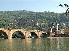
On the lower part of the northwest flank of the Königstuhl stands Heidelberg Castle , one of the most famous ruins in Germany and the symbol of the city of Heidelberg . Until its destruction in the Palatinate War of Succession , it was the residence of the Electors of the Electoral Palatinate . Since the destruction by the soldiers of Louis XIV between 1689 and 1693, the castle , built from Neckar valley sandstone , has only been partially restored. It rises about 80 m above the Neckar and dominates the picture above the old town. The palace garden Hortus Palatinus belongs to the property .
Heidelberg mountain railway
The Heidelberger Bergbahn , a funicular railway , runs on the northwest flank of the Königstuhl . Their carriages have been running in the lower section of the route (Molkenkurbahn) since 1890 , only from the Kornmarkt valley station ( 113.2 m ; Altstadtplatz) through the Heidelberger Schloss station ( 192 m ) to the Molkenkur station ( 289.3 m ; former health resort). From dortiger intermediate station ( switch ) the trolley ride of 1907 opened the upper path portion (Königstuhlbahn) to the mountain station Koenigsstuhl ( 549.8 m ). The 1,491 m long railway line overcomes an altitude difference of 436.6 m.
Ladder to heaven
The Himmelsleiter comprises more than 1200 steps , an irregular staircase made of roughly hewn uneven sandstones leading from Heidelberg Castle directly to the summit region of the Königstuhl. It starts at the first bend of the Molkenkurweg, climbs south and overcomes 270 meters in altitude. Including the steps from Kornmarkt to Heidelberg Castle, there are around 1,600 steps between the base and the summit. The staircase was built from 1844 under the district forester Adam Laumann . In 1994 it was almost completely renovated.
Traffic and walking
Several roads run along and on the Königstuhl massif, including the district road 9710, which leads over the high elevations of the mountain and connects Heidelberg in the west with Waldhilsbach in the southeast. For example, starting on this winding road that leads south of the mountain summit on the Plättleshöhe to a maximum height of 545.1 m and where there are several parking spaces also on the mountain heights, or on the mountain road that runs through Heidelberg to the west of the mountain range, forest trails and paths to be hiked. The European long-distance hiking trail E1 runs over the Königstuhl and through parts of its massif, and the north variant ( Donnersberg - Lautertaler Felsenmeer –Königstuhl) and the south variant (Donnersberg– Eschkopf –Königstuhl) of the European long-distance hiking trail E8 meet there. With its northwestern flank of the 2,487 m long has Königstuhl tunnel which then north of the massif in the valley of the Neckar passing Neckar Valley Railway .
Refuges
The refuges and other structures of the Königstuhl massif, which are mostly located on forest and hiking trails, include (sorted alphabetically); Height specifications in meters (m) above sea level refer, for example, to those at the crossroads or points near the objects:
Auerhahnenhütte ( 521.7 m ), Aukopfhäuschen ( 313 m ), Drei-Eichen-Hütte ( 465.2 m ), Drei-Tröge-Hütte ( 215.6 m ), Felsenmeerhütte (approx. 410 m ), Gemsenberghütte ( 234, 8 m ), Gemsensteinhütte (approx. 370 m ), Gumpentalhütte (approx. 260 m ), Hohler-Kästenbaum-Huts ( 442.2 m ), Hutzelwaldhütte (approx. 270 m ), Kaltteichhütte ( 524 m ), Kraussteinhütte ( 426, 7 m ), Leopold stone cabin ( 526.3 m ), Linsenteicheckhütte ( 308.3 m ), Michel cabin ( 331.1 m ), bovine Häusle (about 330 m ), Rondelhütte (about 250 m ), Schlosshang hut (ca. 460 m ), Schneiderscherehütte (approx. 492 m ), Sprunghöhehütte ( 348.4 m ), Stephanshütte (approx. 380 m ), Vulpiushütte ( Plättleshöhe ; 545.1 m ), Waldparkhütte ( 295 m ) and Weidhaushütte (approx. 439 m ).
Schwetzingen Castle
Almost exactly on the 50 km long line of sight from the Königstuhl summit in the east-northeast to the Kalmit summit ( 672.6 m ) in the west-southwest, located on the other side of the Upper Rhine Plain in the Palatinate Forest part of Haardt , is 11.8 km (as the crow flies ) from the Königstuhl summit, in the lowlands the im Schwetzingen Castle , built in the 17th century . The central axis of the palace and palace gardens is only about 200 m from the line of sight parallel to the north, aligned with a series of streets, roads and field paths that begins on the outskirts of Heidelberg and leads in Schwetzingen via Kurfürstenstrasse and Schlossplatz to the palace entrance . Beyond the garden it continues - with the bridge over the high-speed route Mannheim – Stuttgart and the underpass of the federal motorway 6 in the line of sight - almost as far as the old Rhine arm at Ketsch .
gallery
Views to and on the Königstuhl:
View from Katzenbuckel to the Königstuhl
View from Neu-Edingen to the Königstuhl
Views from the Königstuhl:
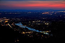
View from the Königstuhl to Heidelberg
View from the Königstuhl into the Neckar and Rhine plains
Web links
Individual evidence
- ↑ a b c d e f g h Map services of the Federal Agency for Nature Conservation ( information )
- ↑ a b c city map of Heidelberg , on map-service.heidelberg.de
- ↑ a b Bergbahn Heidelberg , on bergbahn-heidelberg.de
- ↑ a b Der Große Falk Atlas - Deutschland Detailkarten , M = 1: 200.000, 2004/2005, ISBN 978-3-8279-0381-5
- ↑ Geoportal Baden-Württemberg ( information )


