
Heiligenberg Tower

The Heiligenberg Tower in Heidelberg is a 16.5 m high observation tower , which is located on the right side of the Neckar opposite the Heidelberg old town on the edge of the former St. Stephen's Monastery at 375.5 m above sea level. NHN high Michelsberg, a pre-summit of 439.9 m above sea level. NHN high Heiligenberg stands.
history
The St. Stephen's Monastery was founded on Michelsberg in 1094, which was gradually expanded over the next few centuries, but was dissolved in the 16th century and has since fallen into disrepair. In 1885 the lookout tower was built from the stones of the ruined monastery. A memorial plaque set into the remains of the building next to the tower bears the following inscription:
1885 Erected on the site and from the rubble of the monastery buildings by the Neuenheim Beautification Association and friends from the area
description
The tower, made of red sandstone blocks, has an approximately square floor plan in the lower part up to a height of approx. 4.5 m. It rises above it as a round tower. It has an extension open to the east with a platform at a height of 4.6 m, to which an angled stone staircase on the outside of the tower leads up. On two sides, the platform has a parapet made of stone battlements similar to the parapet of the tower. From here, a spiral staircase inside the tower leads to the 15.25 m high viewing platform , from which there is a good view of the Neckar valley and the Königstuhl .
The Heiligenberg Tower is located directly on the main hiking trail HW7 of the Odenwald Club (184 km long hiking trail Odenwald-Vosges).
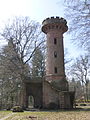
View from the eastern edge of St. Stephen's monastery west-southwest to the Heiligenberg tower

Memorial plaque in memory of the construction of the Heiligenberg Tower
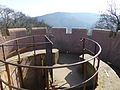
Viewing platform with a view south to the Königstuhl

Information board at the Stephanskloster with the location of the Heiligenberg tower

View from the Heiligenturm to the old town of Heidelberg and the Königstuhl

Heiligenbergturm aerial view with Heidelberg Castle in the background


Individual evidence
- ↑ a b c Information based on measurements carried out privately
- ↑ a b Map services of the Federal Agency for Nature Conservation ( information )
- ↑ The hiking trails of the Odenwaldklub on the Odenwaldklub's website
Web links
Coordinates: 49 ° 25 ′ 10.5 ″ N , 8 ° 42 ′ 15.1 ″ E