
Gaisberg (Heidelberg)
| Gaisberg | ||
|---|---|---|
 View from the summit of the Königsstuhl to the west of the summit of the Gaisberg. On the right the Neckar , which leaves the Odenwald and enters the Upper Rhine Plain. |
||
| height | 375.7 m above sea level NHN | |
| location | in Heidelberg , Baden-Württemberg , Germany | |
| Mountains | Little Odenwald | |
| Dominance | 0.57 km → Königstuhl | |
| Notch height | 28 m ↓ jump height | |
| Coordinates | 49 ° 24 '11 " N , 8 ° 42' 17" E | |
|
||
| rock | Red sandstone | |
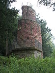
| particularities | Gaisbergturm ( AT ) | |

The Gaisberg - sometimes the spelling Geißberg is found on official maps - is a mountain in the area of the city of Heidelberg , which sits on the western slope of the Königstuhl and thus belongs to the Kleiner Odenwald . It has a height of 375.7 m above sea level. NHN and towers over the old town of Heidelberg in the Neckar valley at its feet by more than 250 m. Its peak is a somewhat elongated, flat knoll from the southeast to the northwest, which is separated from the mountain of the Königstuhl by a saddle about 30 m lower, the jump height . Not far from the highest point is the Gaisberg Tower , which, thanks to a clearing that has been hewn down again and again, provides a view from west to north.
The mostly wooded Gaisberg rises above the Heidelberg Weststadt, which lies on the edge of the Upper Rhine Plain, and above the western parts of the Heidelberg Old Town. It can be reached from many directions on partly steep paths. East of the mountain, at the end of the main ascent of the road from Heidelberg to Gaiberg, at the so-called log cabin, there is a parking lot, from which it can be reached on foot on a path of only 1.7 km with a 70 m gradient, the path with the least Difference in altitude (each way there and back together). The shortest ascent from the old town down in the valley begins at the Stadtgarten and leads on serpentine paths with a total length of about 1.8 km to the tower, albeit with multiple inclines (one way). On this path you pass the place where the Trutzbayer fortification stood during the Bohemian-Palatinate War , apart in rather impassable terrain on the slope you can also find ruins of the other Trutzkaiser fortification . From the birch bank on the upper northern mountain slope you have an excellent view over the Klingenteich to the eastern old town and the flowing Neckar, behind the treetops you can also see parts of the Heidelberg Castle in the vegetation-free season . Further down on this slope, just below the road from the old town to the Speyererhof, is the giant stone , a large table rock. Above all on the north-western and western slopes, there are many chestnut trees between other deciduous trees , which gives the mountain the appearance of a golden, dusty green hood in spring, seen from a distance from the Rhine plain.
Under the Gaisberg and other northern foothills of the Königstuhlstock, the approximately 2.5 km long Königstuhl Tunnel, the first tunnel of the Neckar Valley Railway from Heidelberg main station, runs in a south-west-north-east direction . Further to the north, the foot of the slope crosses under the foot of the slope in a former railway tunnel tube that is not quite 300 m long, the southern lane of the Friedrich-Ebert-Anlage , a southern bypass of the old town, leading to the east .
gallery
- The Gaisberg in Heidelberg

Riesenstein lookout pulpit on Gaisberg above Heidelberg's old town .
Photo with a view of the Heiligenberg and the Neuenheim district
Historical view of the city of Heidelberg

Riesenstein climbing area on the Gaisberg in Heidelberg
The Gaisberg Tower


