Calmont
| Calmont
(Calmond)
|
||
|---|---|---|
| height | 380.6 m above sea level NHN | |
| location | at Bremm and Ediger-Eller ; District of Cochem-Zell , Rhineland-Palatinate ( Germany ) | |
| Coordinates | 50 ° 6 '33 " N , 7 ° 7' 25" E | |
|
|
||
| rock | Slate - weathering rock | |
| particularities | - Gallo-Roman temple handling / Calmont - vineyards Bremmer Calmont and Ellerer Calmont - the viewing platform at the memorial of the war generation - Calmont climbing trail - paraglider launch point |
|
|
Monastery ruins Stuben , Moselle and Calmont |
||


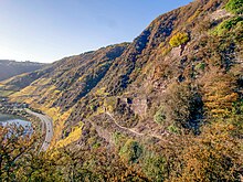
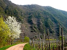
The Calmont , also called Calmond , between Bremm and Ediger-Eller in the district of Cochem-Zell , Rhineland-Palatinate is a steeply rising above the Moselle , a maximum of 380.6 m above sea level. NHN at the edge of the Moselle valley . It is located in the Moselle wine-growing region and has two individual vineyards , Bremmer Calmont and Ellerer Calmont , which are among the steepest on earth with slopes of up to 65 degrees .
Mountain name
The name Calmont can be interpreted in different ways:
- from the Latin calidus "warm" and mons "mountain", thus: "warm mountain",
- from the Celtic kal "hard", thus: "rock mountain"
geography
location
The Calmont rises downstream of the Moselle between Bremm in the south-south-west and Ediger-Eller in the south-east, which lie on the left bank of the river. Its summit is on the municipal boundary; the southern slope belongs to Bremm, the northern and eastern parts belong to Ediger-Eller. The Ellerbach flows north and east around the ridge and flows into the Moselle to the southeast. To the southwest the landscape rises to the sheepfold ( 423 m ).
Natural allocation
The Calmont heard in the natural environment feature unit group Moseltal (no. 25) in the main unit Medium Moseltal (250) and in the sub unit Mittelmosel (250.3) for natural space Cochemer staples (250.33). Its landscape leads to the north, through the Ellerbachtal, to the northwest and west as well as rising to the west-southwest to the sheepfold in the natural area of Gevenich plateau (270.02), which in the main unit group Eastern Eifel (27) and in the main unit Moseleifel (270) to the subunit Eastern Moselle Eifel (270.0) counts.
Mountain height
The 380.6 m high Calmont summit is 293.1 m above the Moselle, where the lowest contour line visible on topographic maps is drawn with a height of 87.5 m . It is on average around 270 m higher than Bremm. A 378.4 m high point is recorded around 215 m east-northeast of the summit .
Protected areas
The Calmont is located in the conservation area Mosel area of Schweich to Koblenz ( CDDA -No 323051;. Reported 1979 1,187.48 square kilometers in size), the Fauna-Flora-Habitat -type region Mosel slopes and side valleys of the lower Mosel (FFH No. 5809-301. 162.73 km²) and in the bird sanctuary forests between Wittlich and Cochem (VSG No. 5908-401; 235.52 km²), whereby the areas of the FFH and bird protection areas do not extend all the way down to the Moselle.
Gallo-Roman common temple
A Roman mountain sanctuary was located on the Calmont summit from the 2nd to the 4th century. The first archaeological excavations were carried out in 2005 and continued in 2008. Following the excavation work, this Gallo-Roman temple was reconstructed, rebuilt and inaugurated on May 16, 2009.
Viticulture
At the end of the 20th century, only part of the original vineyards was cultivated. The largest contiguous area is the Bremmer Calmont with 33 ha. A particularly good Riesling grows on its steep slate slopes , whereby the winemakers are still dependent on manual labor and muscle power (→ steep-slope viticulture ). After viticulture in the Calmont massif declined for decades for reasons of profitability, since 2005 some winegrowers have been ready to replant their areas. They hope that the increasing awareness of the location will result in better sales of their products. One winery now offers the leasing of vines.
Memorial and viewing platform
665 m (as the crow flies ) west-southwest of the Calmont summit is located next to a 372.5 m high point, the memorial of the war generation , a 12 m high cross that is commonly known as the summit cross and was erected around 1970 . In addition to the hut there, which is open from Easter to October as an ostrich tavern , there is a viewing platform on site, from which the view particularly of the loop of the Moselle at the Stuben monastery ruins located 285 m below with, downstream, the villages of Neef , Bremm and Ediger-Eller falls.
Traffic and walking
The federal road 49 runs along the southern foot of the Calmont in a west-east direction between the Moselle villages of Bremm and Ediger-Eller . East to south-east of the ridge, the Moselle route laid out there in north-northeast-south-southwest direction and coming from Cochem leads after the 4205 m long Kaiser Wilhelm tunnel through the Ediger-Eller station and then over a 281 m long Moselle bridge.
The Calmont via ferrata , which was laid out by the German Alpine Association and inaugurated on May 4, 2002 and on which you can discover its mountain world, flora and fauna, runs up the Calmont .
Paragliding
When the wind and weather conditions are right, paragliders start their flights over the Moselle valley near the war generation memorial . The Calmont massif lies like a naturally formed concave mirror in the Moselle valley and, with its southern orientation in connection with the slate-containing subsoil, offers ideal conditions for the development of thermal updrafts.
Power plant project
From the late 1960s, RWE planned the large Bremm pumped storage plant . Its three-kilometer-long Untersee would have been created immediately north of the Calmont (viewed from the Moselle as behind it) in the Ellerbachtal with a dam near the south portal to the Kaiser Wilhelm tunnel . The river water for the operation of the power station should be taken from below the mountain and the power station water should also be drained off. The project was ultimately rejected.
Web links
- Information about Calmont , on calmont.info
- The Bremmer Calmont , on bremmer-calmont.de
Individual evidence
- ↑ a b c d e Map service of the landscape information system of the Rhineland-Palatinate Nature Conservation Administration (LANIS map) ( notes )
- ↑ Land development and rural land management , Ministry for the Environment, Agriculture, Food, Viticulture and Forests of the State of Rhineland-Palatinate, Nachrichtenblatt, Issue 53/2012, p. 12, on rlp.de (PDF; 10.4 MB)
- ↑ Map services of the Federal Agency for Nature Conservation ( information )
- ^ The Gallo-Roman temple on the Calmont , Förderverein Calmont-Region e. V., accessed on January 4, 2014, from calmont-region.de
- ↑ Inauguration of the Gallo-Roman sanctuary on the Calmont in: The Gallo-Roman mountain sanctuary on the Calmont → Inauguration of the mountain sanctuary on May 16, 2009 , accessed on January 4, 2014, on calmont-klettersteig.com
- ↑ Map of the Bremmer Calmont vineyards , on weinlagen-info.de
- ↑ a b The Bremmer Calmont : The Calmont via ferrata and the opening ceremony on May 4, 2002 , accessed on January 4, 2014, on calmont-klettersteig.com
- ↑ Botanical excursion to the Moselle 13.08.2009–16.08.2009 , accessed on September 1, 2015, at botanik-bochum.de


