
Kropsbach
|
Kropsbach section names : Krebsbach, Altenbach, Mühlbachgraben, Schlaggraben |
||
_Hintergasse_-_Kropsbach_P1220629.jpg) Kropsbach in St. Martin |
||
| Data | ||
| Water code | DE : 23786 | |
| location | Rhineland-Palatinate | |
| River system | Rhine | |
| Drain over | Speyerbach → Rhine → North Sea | |
| source |
Kirchquelle / Kirchbrunnen am Schafkopf northwest of St. Martin 49 ° 18 ′ 35 ″ N , 8 ° 3 ′ 19 ″ E |
|
| Source height | 460 m above sea level NHN | |
| muzzle | west of Hanhofen from the right in the Speyerbach Coordinates: 49 ° 18 '48 " N , 8 ° 20' 4" E 49 ° 18 '48 " N , 8 ° 20' 4" E |
|
| Mouth height | approx. 107 m above sea level NHN | |
| Height difference | approx. 353 m | |
| Bottom slope | approx. 16 ‰ | |
| length | 22 km | |
| Catchment area | 104.98 km² | |
| Left tributaries | Hüttenbach, Bach von der Wolselquelle, Bach von der Oberen Mühle, Alsterweiler Bach, Wiesengraben (back after discharge), Schlossgraben (after discharge back again), Hartgraben | |
| Right tributaries | Frauenbach, Riedgraben, Ortelbuschgraben, Wolfsgraben, Triefenbach / Wiesgraben | |
| Reservoirs flowed through | Sand meadow pond , three retention basins between St. Martin and Maikammer, castle pond | |
| Medium-sized cities | Neustadt an der Weinstrasse (districts Duttweiler and Geinsheim ) | |
| Communities | St. Martin , Maikammer , Kirrweiler , Hanhofen | |
The Kropsbach is a 22 km long stream and a right tributary of the Speyerbach in Rhineland-Palatinate . Its catchment area measures almost 105 km².
The stream, whose name is associated with the nearby Kropsburg , also has several different section names . As Krebsbach it flows to the confluence of the Riedgraben at the Duttweiler sewage treatment plant, from there it is called Altenbach and then Mühlbachgraben . From around the confluence of the Schlittgraben it is called Schlaggraben until the end of its course .
geography
source
The Kropsbach rises in the eastern part of the Palatinate Forest at 460 m above sea level. NHN in the church source , which is also called the church fountain . It is located on the forest boundary of the local community of St. Martin , where it emerges as a layer spring on the eastern flank of the 617 m high Schafkopf .
Course and tributaries

Kirchquelle / Kirchbrunnen as Kropsbach origin

Sand meadow pond in the Palatinate Forest
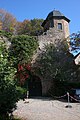
Kropsburg at the exit of the Kropsbach valley

Kropsbach Bridge west of Hanhofen
.JPG)


In the Palatinate Forest, the Kropsbach flows consistently in a south-easterly direction. After 700 m it takes up the 300 m long Hüttenbach from the left , which comes from the St. Martiner Grillhütte . Below the Kropsbach is dammed up to the 150 m long and 60 m wide sand meadow pond; A few meters to the south, on the slope, is the Haus an den Fichten , a managed refuge of the Palatinate Forest Association . Shortly after the Wetzbrunnen on the right, where the Ritterstein 243 is located, the brook from the Wolsel spring flows out on the left (500 m). After the Frauenbach (450 m) has flown 1 km further from the right , the Kropsbach breaks through the eastern edge of the Palatinate Forest, the Haardt , and reaches the wine-growing village of St. Martin, where the hilly vineyard landscape on the German Wine Route begins.
Below the municipality, the Kropsbach turns more to the east and flows through three small retention basins , which can absorb rainwater from the adjacent vineyards via ditches running across the slope during heavy rain . In Maikammer , the Kropsbach leaves the hilly landscape. From the left it receives the Alsterweiler Bach, which is a little over 5 km long, and arrives at Kirrweiler . There it feeds the castle pond, which is a good 300 m long and 150 m at its widest point , and which was once dammed to secure the upper castle , which was later abandoned . Around the confluence of its 5.3 km long right tributary Riedgraben , the Kropsbach changes from the southern Palatinate to the Upper Palatinate . In the western part of the Rhine plain, it flows through the Neustadt districts of Duttweiler and Geinsheim one after the other . Below Geinsheim it takes up the 14.2 km long Hartgraben from the left and then receives its strongest inflow from the right, the 23 km long Wiesgraben , which is called Triefenbach in the source area .
muzzle
For the last 2 km of its course to the northeast, the Kropsbach flows into the Speyerbach from the right on the western edge of the Hanhofen community at an altitude of about 107 m . The Hanhofer Wassergescheid is only 25 m downhill , where the Woogbach is diverted to the left from the Speyerbach .
Attractions
Grazing project

In 2011, to the northwest of the sand meadow pond and west of the grill hut, an approximately 41 hectare forest and meadow area was fenced in as a grazing project sand meadow ponds and a herd of rear cattle settled. The grazing by these cattle, which were bred from the aurochs , which died out in 1627 and whose bulls can weigh up to 900 kg, should cause the sparse pine forest to lose its character of a monoculture and regain its biodiversity .
The 4.5 km long aurochs trail along the pasture fence and past the house by the spruce trees enables circular hikes. Cars can be parked in the St. Martiner Tal car park by the grill hut or in the car park on the sandy meadows by the Wetzbrunnen.
Kropsburg
Above the town of St. Martin, right above the output of Kropsbachtals, lies on the spur of a foothill of Haardt in 250 m height the ruined from the Middle Ages derived Kropsburg . Its construction around the year 1200 goes back to the ruling family of the Staufer . At that time, a whole ring of castles was built to shield the Trifels castle near Annweiler, some 20 km away .
The Kropsburg can be reached via hiking trails and by car. A restaurant is operated in the outer bailey, the terrace of which offers a panoramic view of the Rhine plain.
Center of St. Martin
The medieval town center of St. Martin is classified as a monument zone . The name of the village goes back to the patron of the predominantly late Gothic church .
traffic
In the Palatinate Forest, the Kropsbach accompanies the country road 514 to the edge of the mountains , which is of touristic importance as the Totenkopfstraße . On the western edge of the Rhine plain, the Kropsbach is crossed by the German Wine Route and the Neustadt – Wissembourg railway line . The Autobahn 65 ( Ludwigshafen - Karlsruhe ) crosses the brook 1 km to the east . Between Geinsheim and Hanhofen, the water gradually approaches the federal highway 39 ( Neustadt - Speyer ) from the southwest , but flows just south of the route.
Individual evidence
- ↑ a b Map service of the landscape information system of the Rhineland-Palatinate Nature Conservation Administration (LANIS map) ( notes )
- ↑ a b c d GeoExplorer of the Rhineland-Palatinate Water Management Authority ( information )
- ↑ a b Ochsentour - Sandwiesenweiher grazing project. sankt-martin.de, accessed on February 1, 2019 .
- ^ Offspring among the "aurochs" . In: The Rheinpfalz , Südwestdeutsche Zeitung . Ludwigshafen June 21, 2011.
- ^ Kropsburg Castle. kropsburg.de, accessed on February 1, 2019 .