
Kirrweiler (Palatinate)
| coat of arms | Germany map | |
|---|---|---|
_COA.svg)
|
Coordinates: 49 ° 18 ' N , 8 ° 10' E |
|
| Basic data | ||
| State : | Rhineland-Palatinate | |
| County : | Southern Wine Route | |
| Association municipality : | May Chamber | |
| Height : | 140 m above sea level NHN | |
| Area : | 14.85 km 2 | |
| Residents: | 2005 (Dec. 31, 2019) | |
| Population density : | 135 inhabitants per km 2 | |
| Postal code : | 67489 | |
| Area code : | 06321 | |
| License plate : | SOUTH | |
| Community key : | 07 3 37 047 | |
| Association administration address: | Immengartenstrasse 24 67487 Maikammer |
|
| Website : | ||
| Local Mayor : | Rolf Metzger | |
| Location of the local community Kirrweiler (Pfalz) in the district of Südliche Weinstrasse | ||
 _in_S%C3%9CW.svg) |
||


Kirrweiler (Pfalz) is a municipality in the Südliche Weinstrasse district in Rhineland-Palatinate . It belongs to the Maikammer community , within which it is the largest local community in terms of area.
geography
location
Kirrweiler is located in the Palatinate between Neustadt an der Weinstrasse and Landau in the Palatinate on the edge of the Palatinate Forest in the middle of the Gäu . The community also includes two exclaves in the Palatinate Forest; one of which reaches as far as the Elmsteiner Tal and through which it represents the most northerly local community in the southern wine route district.
Neighboring communities are - clockwise - Neustadt an der Weinstrasse, Altdorf , Venningen , Edenkoben and Maikammer . The eastern exclave borders clockwise - exclaves in italics - Sankt Martin , Edenkoben, Altdorf , Böbingen and Gommersheim . The other exclave to the west borders on Esthal , Neustadt an der Weinstrasse, Maikammer, Gommersheim , Böbingen , Altdorf , Venningen and Elmstein .
Elevations and waters
The Kropsbach flows through the municipality in a west-east direction; On site, this feeds the castle pond . Its right tributary Riedgraben largely forms the boundary to Venningen.
The 608.3 meter high Morschenberg extends within one exclave . In the other, further to the northwest, is the western flank of the approximately 489 meter high pulpit head . In the north-west this is limited by the Speyerbach , in the north-east by the Argenbach and in the west by the Helmbach and the Kohlbach . It also includes the east bank of the Helmbachweiher . The Argenbach also takes on the Habichtstalbach, which runs along its entire length within the Wadlexklave, from the left .
history

There was once a moated castle of the bishops of Speyer, which was first mentioned in 1280. It was the seat of the episcopal office since the 16th century. In the 18th century a new castle was built by Johann Leonhard Stahl . The castle went down in the French Revolution. Only the conduct is preserved.
According to tax statistics from 1341, Kirrweiler had to pay a tax of £ 28 pfennigs annually to the Speyer Monastery to which the community belonged at that time. Until the end of the 18th century, the place belonged to the aforementioned bishopric; within this, the community was the seat of an upper office of the same name . In 1794 the battle of Kirrweiler took place on site .
From 1798 to 1814, when the Palatinate was part of the French Republic (until 1804) and then part of the Napoleonic Empire , Kirrweiler was incorporated into the canton of Edenkoben in the department of the Lower Rhine and had its own Mairie . In 1815 the community had a total of 1,310 inhabitants. In the same year, Austria was struck. Just one year later, the place, like the entire Palatinate, changed to the Kingdom of Bavaria . From 1818 to 1862 Kirrweiler belonged to the Landau Landau commissioner ; from this the district office of Landau emerged.
From 1939 the place was part of the district of the Palatinate . After the Second World War , Kirrweiler became part of the then newly formed state of Rhineland-Palatinate within the French occupation zone . In the course of the first Rhineland-Palatinate administrative reform changed the place on 7 June 1969 in the newly created district Landau-Bad Bergzabern, in 1978 in South County Wine Trail is renamed . In 1972 Kirrweiler was assigned to the also newly formed Maikammer Association. Due to the dissolution of the latter, Kirrweiler was initially part of the community of Edenkoben from July 2014 , before the Maikammer counterpart was restored a year later by judgment of the Constitutional Court .
religion

On October 31, 2014, 59.1 percent of the population were Catholic and 23.4 percent Protestant. The rest belonged to another religion or were non-denominational.
Christianity
The Catholics belong to the Diocese of Speyer , the Evangelicals to the Protestant Church of the Palatinate .
The famous wooden miraculous image of the "Patrona Spirensis" from the Speyer Cathedral , in front of which St. Bernard of Clairvaux had already prayed, was transferred to the church in Kirrweiler by Vicar General Heinrich Hartard von Rollingen after it had survived the cathedral fire in 1689 . From there, the statue of the Virgin returned to the cathedral, but fell victim to French revolutionaries in Speyer in 1794, who burned it. There is only one foot of the baby Jesus that was broken off before, as a relic. In 1930 the Speyer Cathedral received a new miraculous image, which is based on the appearance of the old one.
Judaism
There was once a synagogue on site , which was profaned as early as the early 20th century and whose building was preserved, as well as a Jewish cemetery .
politics

Municipal council
The local council in Kirrweiler consists of 16 council members, who were elected in the local elections on May 26, 2019 in a personalized proportional representation, and the honorary local mayor as chairman.
The distribution of seats in the municipal council:
| choice | SPD | CDU | BL | total |
|---|---|---|---|---|
| 2019 | 1 | 5 | 10 | 16 seats |
| 2014 | 1 | 6th | 9 | 16 seats |
| 2009 | 1 | 7th | 8th | 16 seats |
| 2004 | 2 | 9 | 5 | 16 seats |
- BL = Bürgerliste e. V.
mayor
Mayor has been Rolf Metzger from BL since 2009. In the direct election on May 26, 2019, he was confirmed in his office for another five years with a share of 80.94% of the votes. His predecessor was Hans-Peter Stollhof.
coat of arms
|
|
Blazon : "In silver a black cross, the shaft of which is bent upwards to the left in the shape of a hook." |
| Foundation for the coat of arms: It was approved by the Mainz Ministry of the Interior in 1962 and goes back to a seal from 1703. It reminds us that Kirrweiler was the official place of the Speyer Monastery . |
Town twinning
Partnerships exist with Kirrweiler in the district of Kusel as well as with Kirrwiller in Alsace and Kirviller in Lorraine .
Culture and sights

Lady Chapel at the cemetery
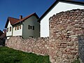
Remains of the city wall


Cultural monuments
The Jewish cemetery, Marktstrasse, the town center and the fortifications are each designated as monument zones. In the latter case, remains of a wall around Kirrweiler are left; it was built at the time when there was still a castle in Kirrweiler.
There are also numerous individual objects that are under monument protection , including the Marienkapelle at the cemetery. It was built between 1765 and 1769 and is dedicated to the "mater dolorosa". In 1964 it was renovated and refurbished with stucco and ceiling paintings (Gschwendner). The local Gasthaus Zur Krone is another cultural monument .
nature
The only natural monument on site is an ensemble of three horse chestnuts . The two exclaves are part of the Palatinate Forest Nature Park . In one there is the Ritterstein 92 , which refers to the neighboring Röhringsbrunnen.
Regular events
The wine festival takes place every year on the first weekend in July. The Kerwe takes place every year on the second weekend in September in the community.
Economy and Infrastructure
economy

Kirrweiler is significantly influenced by viticulture and is one of the largest wine-growing communities in the Palatinate . The area under vines was 594 hectares in 2005. The individual layers Mandelberg , Oberschloss and Römerweg , all of which are part of the Maikammerer Mandelhöhe area, are located within the municipality .
In the course of the Haingeraide , Kirrweiler was involved in the so-called fifth Haingeraiden , which was dissolved in the early modern period and which was partially subordinated to the community. The forester's house in Breitenstein is also located in the western exclave .
traffic
- Street

State road 515 , which connects it with Maikammer and Duttweiler, runs through the community in a west-east direction . In the middle of the settlement area, the state road 542 branches off to the south and leads to Kandel . The closest motorway connection to the A 65 is Edenkoben . Bus line 504 operated by PalatinaBus of the Rhein-Neckar transport association runs through the village and connects the village with Maikammer; individual journeys are tied through to Edenkoben. The Totenkopfstraße runs partially through the western forest enclave.
- rail
Together with Maikammer, Kirrweiler has the Maikammer-Kirrweiler stop on the Palatinate Maximiliansbahn , which opened in 1855 and from which trains run to Neustadt , Karlsruhe and Wissembourg . The operating site used to be a train station and is located in an industrial park . In the 1980s it was rebuilt and the central platform was replaced by a side platform . The station building corresponded to the typical type of construction in the Palatinate. Like the goods hall and the loading ramp, it is no longer relevant for rail operations. In the meantime it has been modernized, the platforms have been raised and its surroundings have been redesigned.
tourism
In addition, the community is on the north route of the Palatinate Way of St. James . The St. Martin Hut, inaugurated in 1904 and operated by the Palatinate Forest Association , is located within the forest enclave to the east . The Saar-Rhein-Main long-distance hiking trail marked with a yellow cross and which leads from Homburg to Wörth am Main and a path marked with a green-yellow cross run through the western forest enclave . This leads from Bexbach via Neustadt an der Weinstrasse to Ludwigshafen am Rhein . One, which is marked with a green and white bar , runs through both exclaves and connects Hertlingshausen with Sankt Martin.
education
There is a primary school on site.
Personalities
Honorary citizen
- Sister Quirinia
- Wolfgang Roth
- Ludwig Sebastian
Sons and daughters of the church
- Florence von Venningen (1466–1538), lawyer and pharmacist in Heidelberg
- Georg Schweicker (~ 1500–1563), Auxiliary Bishop of Speyer, participant in the Council of Trento
- Alexius von Speyer (1583–1629), famous Capuchin, closest collaborator of Saint Fidelis von Sigmaringen .
- Anselm Franz Speck (~ 1728–1798); Bell caster
People who worked on site
- Johann Ignaz Seuffert (1728–1807), organ builder from Speyer, built over 30 organs and died on site
- Joseph Guhmann (1762–1843), civil servant, from around 1794 clerk in Kirrweiler
- Max Asam (1936–2015), Brigadier General of the Bundeswehr, died on the spot
- Dominique Heintz (* 1993), soccer player, played for the local soccer club until 2001
literature
- Heinz Friedel : Kirrweiler. The story of a Palatinate wine village . Ed .: Verbandsgemeinde Maikammer. Kirrweiler 1978.
Web links
- Internet presence of the local community Kirrweiler
- Kirrweiler
- Literature about Kirrweiler in the Rhineland-Palatinate state bibliography
Individual evidence
- ↑ State Statistical Office of Rhineland-Palatinate - population status 2019, districts, communities, association communities ( help on this ).
- ^ Georg Dehio, Handbook of Art Monuments - Rhineland-Palatinate Saarland. Hans Caspary, Wolfgang Götz, Ekkart Klinge, Peter Karn and Martin Klewitz. Darmstadt 1985
- ↑ Municipal statistics . In: KommWis. October 31, 2014, accessed November 30, 2014 .
- ↑ On the Patrona Spirensis ( Memento of the original of July 25, 2014 in the Internet Archive ) Info: The archive link has been inserted automatically and has not yet been checked. Please check the original and archive link according to the instructions and then remove this notice.
- ↑ Communications of the Historical Association of the Palatinate, Volumes 1-6. To transfer the miraculous image to Kirrweiler . 1871, p. 106 ( limited preview in Google Book search).
- ^ The Regional Returning Officer Rhineland-Palatinate: Local elections 2019, city and municipal council elections
- ^ Rolf Metzger: Mayor of the town. Kirrweiler parish, accessed on April 11, 2020 .
- ^ The Regional Returning Officer of Rhineland-Palatinate: direct elections 2019. see Maikammer, Verbandsgemeinde, first line of results. Retrieved April 11, 2020 .
- ^ Karl Heinz Debus: The great book of arms of the Palatinate. Neustadt an der Weinstrasse 1988, ISBN 3-9801574-2-3 .
- ↑ References for the railway construction supervisor - line expansion / line upgrading / station facilities. (PDF) In: si-kl.de. Retrieved January 13, 2014 .

Cities: Annweiler am Trifels | Bad Bergzabern | Edenkoben
Municipalities: Albersweiler | Altdorf (Palatinate) | Barbelroth | Cheapheim-Ingenheim | Birkenhördt | Birkweiler | Böbingen (Palatinate) | Böchingen | Böllenborn | Bornheim (Palatinate) | Burrweiler | Dernbach (Palatinate) | Dierbach | Dörrenbach | Edesheim | Eschbach (Palatinate) | Essingen (Palatinate) | Eusserthal | Flemlingen | Frankweiler | Freimersheim (Palatinate) | Gleisweiler | Gleiszellen-Gleishorbach | Goecklingen | Gommersheim | Gossersweiler-Stein | Großfischlingen | Hainfeld (Palatinate) | Hergersweiler | Herxheim near Landau / Pfalz | Herxheimweyher | Heuchelheim Blades | Hochstadt (Palatinate) | Ilbesheim near Landau in the Palatinate | Vaccinees | Insheim | Kapellen-Drusweiler | Kapsweyer | Kirrweiler (Palatinate) | Small fish | Klingenmünster | Knöringen | Leinsweiler | May Chamber | Münchweiler am Klingbach | Niederhorbach | Niederotterbach | Oberhausen (near Bad Bergzabern) | Oberotterbach | Oberschlettenbach | Offenbach an der Queich | Pleisweiler-Oberhofen | Ramberg (Palatinate) | Ranschbach | Rhodt under Rietburg | Rinnthal | Rohrbach (Palatinate) | Roschbach | Saint Martin (Palatinate) | Schweigen-Rechtenbach | Schweighofen | Siebeldingen | Silz | Steinfeld (Palatinate) | Venningen | Völkersweiler | Vorderweidenthal | Waldhambach | Waldrohrbach | Walsheim | Wernersberg | Weyher in the Palatinate