Argenbach (Speyerbach)
| Argenbach | ||
|
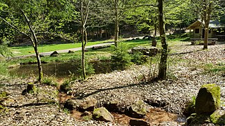
Four beeches in the Kleyental. The Argenbach comes from the right and flows through the pond. The Argenbach source is about 50 meters further south |
||
| Data | ||
| Water code | DE : 237832 | |
| location |
Palatinate Forest
|
|
| River system | Speyerbach | |
| Drain over | Speyerbach → Rhine → North Sea | |
| source | at St. Martin 49 ° 18 ′ 18 ″ N , 8 ° 1 ′ 28 ″ E |
|
| Source height | 396 m above sea level NHN | |
| muzzle | near Breitenstein in the Speyerbach Coordinates: 49 ° 20 '39 " N , 8 ° 0' 4" E 49 ° 20 '39 " N , 8 ° 0' 4" E |
|
| Mouth height | 192 m above sea level NHN | |
| Height difference | 204 m | |
| Bottom slope | 37 ‰ | |
| length | 5.5 km | |
| Catchment area | 10.9 km² | |
The Argenbach is a brook in the central Palatinate Forest .
geography
course
The Argenbach rises on the Maikammer forest area . First of all, it flows north-west. After about two kilometers, it crosses under Totenkopfstrasse and then runs parallel to it. Its direction changes to north-northwest and is located on the forest area of Neustadt an der Weinstrasse . In the last few kilometers it essentially forms the boundary between Neustadt and the Kirrweiler forest . At the level of Breitenstein it flows into the Speyerbach . Shortly before, he crossed under the cuckoo path ; The Breitenstein stop is located directly on a bridge over the Argenbach.
Tributaries
- Kleyenbach ( left )
- Habichtstalbach ( left ), 0.4 miles
Individual evidence
- ↑ a b Map service of the landscape information system of the Rhineland-Palatinate Nature Conservation Administration (LANIS map) ( notes )
- ↑ a b GeoExplorer of the Rhineland-Palatinate Water Management Authority ( information )
- ^ Name at LANIS
- ↑ Own measurement at LANIS
Web links
- The Argenbach at LANIS
