
Eusserthal
| coat of arms | Germany map | |
|---|---|---|

|
Coordinates: 49 ° 15 ' N , 7 ° 58' E |
|
| Basic data | ||
| State : | Rhineland-Palatinate | |
| County : | Southern Wine Route | |
| Association municipality : | Annweiler am Trifels | |
| Height : | 195 m above sea level NHN | |
| Area : | 12.52 km 2 | |
| Residents: | 874 (Dec. 31, 2019) | |
| Population density : | 70 inhabitants per km 2 | |
| Postal code : | 76857 | |
| Area code : | 06345 | |
| License plate : | SOUTH | |
| Community key : | 07 3 37 024 | |
| Association administration address: | Messplatz 1 76855 Annweiler am Trifels |
|
| Website : | ||
| Local Mayor : | Reinhard Denny | |
| Location of the local community Eusserthal in the district of Südliche Weinstrasse | ||
  |
||

Eusserthal is a municipality in the Südliche Weinstrasse district ( Rhineland-Palatinate ). It belongs to the Verbandsgemeinde Annweiler am Trifels , within which it is the third largest in terms of area and the sixth largest in terms of population.
geography
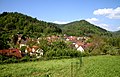
View of Eusserthal

Eusserbach below the community


location
Eusserthal is located in the southern Palatinate region in the east of the Palatinate Forest in its Annweiler-Albersweiler-Ausraum sub-area , which is alternatively known as Trifelsland . The place is laid out as a street village. The Vogelstockerhof in the south also belongs to the community . In a clockwise direction, neighboring communities - including exclaves - are Landau in der Pfalz , Gleisweiler , Dernbach , Albersweiler , Annweiler am Trifels , Rinnthal , Birkweiler and Siebeldingen .
Waters
The place extends along the Eusserbach , which flows from northwest to southeast and belongs to the river system of the Queich . To the north of the settlement area, it is dammed up to form the Schweinswoog and then takes on the Dürrentalbach from the right . To the southeast of the settlement area, the Eischbach, which runs in north-south direction, flows into the Eusserbach from the right . In the southeast, the Dernbach forms the border with Albersweiler and Annweiler.
Surveys
Ranges of hills that belong to the central Palatinate Forest run on both sides of the community . The largest elevations in the surrounding area are - already beyond the municipal boundary - the Döreneck ( 513.8 m ) and the Harzofenberg ( 556.4 m ) to the left of the Eußerbach in the north and northeast as well as the Almersberg ( 564.1 m ) and on the border Annweiler and Rinnthal the Kehrenkopf (alternatively Kehrkopf ; 529.7 m ) on the right side of the stream in the west and south-west. The 518.2 m high Meisenhorn rises on the border to the forest enclaves of Landau and Gleisweiler .
In the north-west of the municipality markings are the container head and closer to the settlement area the 411.2 m high Prestenberg . To the southeast are the Great and the Small Eischkopf , immediately southwest of the settlement area extends the Krause Berg .
history
The village emerged around a Cistercian monastery founded in 1148. Only sparse remains of the actual Eusserthal monastery remain, but its former church is still the Catholic church of the community today.
The imperial regalia were entrusted to the abbot of the monastery when, in 1208, after King Philip of Swabia had been murdered, Konrad III. von Scharfenberg , Chancellor of the Holy Roman Empire and Bishop of Speyer , were brought to safety at the nearby Trifels Imperial Castle . Even after the end of the period of custody, the priests from Eusserthal performed services at the castle.
Until the end of the 18th century, the community belonged to the Electoral Palatinate and was subordinate to the Oberamt Germersheim . From 1798 to 1814, when the Palatinate was part of the French Republic (until 1804) and then part of the Napoleonic Empire , Euserthal - as it was spelled at the time - was incorporated into the canton of Annweiler and was subordinate to Mairie Ramberg . In 1815 the community had a total of 400 inhabitants. In the same year, Austria was added, and a year later, like the entire Palatinate, it moved to the Kingdom of Bavaria . From 1818 to 1862 Euserthal belonged to the Land Commissioner Bergzabern ; from this the district office Bergzabern emerged.
From 1939 the place was part of the Bergzabern district . After the Second World War , Eusserthal became part of the then newly formed state of Rhineland-Palatinate within the French occupation zone . In the course of the first Rhineland-Palatinate administrative reform , the place changed on June 7, 1969 to the newly created Landau-Bad Bergzabern district , which was renamed the Südliche Weinstrasse district in 1978 . 1972 Eußerthal was assigned to the also newly formed community of Annweiler am Trifels .
politics
Municipal council
The municipal council in Eußerthal consists of twelve council members, who were elected in a majority vote in the local elections on May 26, 2019 , and the honorary local mayor as chairman.
The distribution of seats in the municipal council:
| choice | SPD | CDU | FWG | WGR | total |
|---|---|---|---|---|---|
| 2019 | by majority vote | 12 seats | |||
| 2014 | 2 | - | - | 10 | 12 seats |
| 2009 | 1 | 3 | 1 | 7th | 12 seats |
| 2004 | 2 | 4th | 3 | 3 | 12 seats |
mayor
Reinhard Denny has been the local mayor of Eusserthal since 2004. In the direct election on May 26, 2019, he was confirmed in office for another five years with a share of 85.11% of the votes.
coat of arms
|
|
Blazon : "In blue on a golden throne St. Bernard with a golden alb and nimbus, the right raised to the oath, in the left a golden crook." |
Sights and culture
Cultural monuments
A total of 15 objects in the village are under monument protection .

Eusserthal monastery church

Protestant church


The most important building is the church of the former Eußerthal monastery, which was built as a pillar basilica in the late Romanesque and is under the patronage of St. Bernard of Clairvaux . In addition to a number of buildings that also date back to the Middle Ages , the Protestant church, a neo-Gothic sandstone block building from 1901/02, is also worth seeing.
nature
In the north of the district is the Katzenfelsen , in the east there is a natural forest reserve , which was designated in 1995 and encompasses 44 hectares, as well as the 58 hectare core zone Eischkopf of the Palatinate Forest Nature Park .
theatre
The open-air theater Eusserthal mainly presents performances with regional and historical references.
societies
Eußerthal has a local branch of the Palatinate Forest Association .
Economy and Infrastructure
economy
Until the first half of the 20th century, Eusserthal was very important for forestry due to its location in the middle of the Palatinate Forest . Their decline began after the Second World War . In the meantime, the place has become a residential community that has opened up more and more to tourism . In the middle of the village was the monastery mill , whose property is now known as the old mill .
Specialist clinic for addicts

The specialist clinic Eußerthal of the German Pension Insurance Rhineland-Palatinate , located outside the village, is a rehabilitation clinic for people with addictive disorders . The clinic was founded in 1905 and is the only one of its kind within the German Pension Insurance.
traffic
Eusserthal is located 5 km northwest of the federal road 10 Pirmasens -Landau, to which the place is connected via the state road 505 . The latter leads in a northerly direction to the Landauer Forsthaus Taubensuhl . The next motorway junction is also reached via the B 10, No. 15 Landau-Nord on the A 65 Ludwigshafen - Karlsruhe .
With regard to local public transport , the place is supplied by the Rhein-Neckar transport association . The next train stop is in Albersweiler on the Landau – Rohrbach railway line , about 5 km southeast of Eusserthal. The place is connected to the local transport network via bus line 521, which connects it with Landau in der Pfalz , Frankweiler , Albersweiler, Dernbach and Ramberg . From May to October, there is also the 532 bus, which connects the town with Annweiler and the Taubensuhl forest house, among others .
tourism

Several hiking trails lead through Eusserthal, including the Pfälzer Weinsteig, a so-called predicate hiking trail . Another is marked with a green-blue bar and runs from Göllheim to Eppenbrunn . There is also a hiking trail that is marked with a white and blue bar and leads from Bad Münster am Stein to Sankt Germanshof . In addition, the community is located on Höcherbergweg , which begins in Niederwürzbach and which is marked with a red and white bar ; its eastern end point is in Böchingen . The hiking trail marked with a yellow bar connects Eusserthal with Contwig and Germersheim . The PWV-Hütte Eußerthal is located in the south of the municipality on the boundary of Annweiler , but there is no hospitality or overnight stay.
Personalities
- Heinrich von Metz († 1336), lived here from 1297 to 1306 as a Cistercian abbot; 1306–1309 he held the same office in the Eusserthal mother monastery Weiler-Bettnach , 1310–1336 he was Prince-Bishop of Trient . From 1309 at the latest, he also acted as Chancellor of King Henry VII.
- Johann Peter Frank (1745–1821), doctor, went to school in Eusserthal.
- Theodor Nauerz (1909–2007) was a pastor in Eusserthal at times.
- Hermann Arnold (1912–2005), a physician, tried to underpin the National Socialist ideology by manipulating data with Sinti living there.
literature
- Heribert Feldhaus: The former Cistercian monastery Eusserthal . Imhof Verlag, Petersberg 2008. ISBN 3-86568-255-3 .
Web links
- Trifelsland: Eusserthal (town portrait)
- Literature about Eusserthal in the Rhineland-Palatinate State Bibliography
Individual evidence
- ↑ State Statistical Office of Rhineland-Palatinate - population status 2019, districts, communities, association communities ( help on this ).
- ↑ Hauptstraße in Eusserthal from the SWR Landesschau Rheinland-Pfalz , accessed on June 16, 2014.
- ^ The Regional Returning Officer Rhineland-Palatinate: Local elections 2019, city and municipal council elections.
- ↑ Gerhard Sommer: On Case II: Which local chiefs in Trifelsland are running again. September 14, 2018, accessed April 15, 2020 .
- ↑ The Regional Returning Officer Rhineland-Palatinate: direct elections 2019. Accessed on April 15, 2020 (Annweiler am Trifels, Verbandsgemeinde, fourth row of results).
- ↑ Website of the Eusserthal open-air theater.
- ↑ Press release of the Deutsche Rentenversicherung Rheinland-Pfalz from January 22nd, 2014: Specialist clinic Eusserthal: Groundbreaking for replacement building. On: www.deutsche-rentenversicherung.de

Cities: Annweiler am Trifels | Bad Bergzabern | Edenkoben
Municipalities: Albersweiler | Altdorf (Palatinate) | Barbelroth | Cheapheim-Ingenheim | Birkenhördt | Birkweiler | Böbingen (Palatinate) | Böchingen | Böllenborn | Bornheim (Palatinate) | Burrweiler | Dernbach (Palatinate) | Dierbach | Dörrenbach | Edesheim | Eschbach (Palatinate) | Essingen (Palatinate) | Eusserthal | Flemlingen | Frankweiler | Freimersheim (Palatinate) | Gleisweiler | Gleiszellen-Gleishorbach | Goecklingen | Gommersheim | Gossersweiler-Stein | Großfischlingen | Hainfeld (Palatinate) | Hergersweiler | Herxheim near Landau / Pfalz | Herxheimweyher | Heuchelheim Blades | Hochstadt (Palatinate) | Ilbesheim near Landau in the Palatinate | Vaccinees | Insheim | Kapellen-Drusweiler | Kapsweyer | Kirrweiler (Palatinate) | Small fish | Klingenmünster | Knöringen | Leinsweiler | May Chamber | Münchweiler am Klingbach | Niederhorbach | Niederotterbach | Oberhausen (near Bad Bergzabern) | Oberotterbach | Oberschlettenbach | Offenbach an der Queich | Pleisweiler-Oberhofen | Ramberg (Palatinate) | Ranschbach | Rhodt under Rietburg | Rinnthal | Rohrbach (Palatinate) | Roschbach | Saint Martin (Palatinate) | Schweigen-Rechtenbach | Schweighofen | Siebeldingen | Silz | Steinfeld (Palatinate) | Venningen | Völkersweiler | Vorderweidenthal | Waldhambach | Waldrohrbach | Walsheim | Wernersberg | Weyher in the Palatinate