
Eusserbach
|
Eusserbach upper course Katzenbach |
||
 Eusserbach below Eusserthal |
||
| Data | ||
| Water code | DE : 237726 | |
| location |
Haardt Mountains
|
|
| River system | Rhine | |
| Drain over | Eisbach → Queich → Rhine → North Sea | |
| source | near the Pfaffenkopf in the Middle Palatinate Forest 49 ° 17 ′ 20 ″ N , 7 ° 58 ′ 30 ″ E |
|
| Source height | approx. 348 m above sea level NHN | |
| confluence | with the Dernbach to Eisbach Coordinates: 49 ° 13 '47 " N , 7 ° 59' 53" E 49 ° 13 '47 " N , 7 ° 59' 53" E |
|
| Mouth height | approx. 174 m above sea level NHN | |
| Height difference | approx. 174 m | |
| Bottom slope | approx. 20 ‰ | |
| length | 8.9 km (10.48 km including Eisbach ) |
|
| Catchment area | 32.89 km² (49.75 km² including Eisbach ) |
|
| Left tributaries | → Section tributaries | |
| Right tributaries | → Section tributaries | |
| Reservoirs flowed through | Trout pond Schweinswoog north of Eusserthal | |
| Small towns | Annweiler am Trifels | |
| Communities | Eusserthal | |
The Eußerbach with its upper course Katzenbach is a flowing water in the Rhineland-Palatinate district of Südliche Weinstrasse and the almost 9 km long, right or northwestern source brook of the Eisbach . The water management administration of Rhineland-Palatinate specifies the length of the Eusserbach including the approximately 1.5 km long Eisbach as 10.48 km.
geography
course
The Eußerbach rises as Katzenbach in the Middle Palatinate Forest at about 348 m above sea level. NHN in a valley belonging to the Roschbach Forest 1 km west-southwest of the 566 m high Pfaffenkopf and initially flows largely in a southerly direction.
Then the Katzenbach turns clearly to the south-west and unites at about 232 m altitude with the Dörenbach coming from the right from the north-west to form the Eusserbach, which in turn flows south. 2 km it is the 450 m long Schweinswoog dammed where trout breed is operated.
At the entrance to the local community of Eußerthal , the Dürrentalbach flows as the strongest inlet at about 202 m above sea level from the right , which is also called Sulzbach here on its lower course and has given its name to an Eusserthaler Weg. For the rest of its course, the Eußerbach flows south-east. Within the municipality, the Mühlbach branches off to the right and is re-introduced after 1 km; it once served as a canal to supply a mill , which was named Klostermühle after the Cistercian Abbey of Eusserthal and is now called the Alte Mühle . Below Eußerthal, the Eußerbach experiences a second, also temporary branch to the right, which is about 800 m long, and receives the Eischbach from the left .
In the district town Annweiler am Trifels the Eußerbach combined at about 174 m height with the coming of the left Northeast, nearly 7.5 km long Dernbach to Eisbach , which already is 1.5 km away from the left in the Rhine tributary Queich opens .
Tributaries
- Flemlinger Bach ( right ), 0.4 km, 0.69 km²
- Walsheimer Bach ( right ), 0.2 km, 0.24 km²
- Katzentalbach ( left ), 0.2 km, 0.76 km²
- Dörenbach ( right ), 3.4 km, 7.25 km²
- Krappengraben ( right ), 0.4 km, 0.38 km²
- Lauberstalbach ( left ), 0.7 km, 1.60 km²
- Dürrentalbach , on the Unterlauf also Sulzbach ( right ), 3.9 km, 7.30 km²
- Prestenbach ( right ), 0.9 km, 1.16 km²
- Auerbach ( right ), 0.2 km, 0.30 km²
- Eischbach ( left ), 2.2 km, 1.70 km²
- Ruthenbach ( right ), 0.9 km, 0.54 km²
traffic
Part of the Eußerbach and its right tributary Dürrentalbach in full flow parallel to the state road 505, which is narrow and winding from the B 10 ( Pirmasens - Landau ) in the south through Eusserthal to the Taubensuhl forest house in the northwest.
Attractions
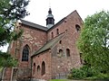
Eusserthal monastery church

Indoor shot

Evangelical parish church
.JPG)
.JPG)

Monastery Church - The most historically significant building in the Eusserbach Valley is the Romanesque St. Bernhard church of the former Cistercian Abbey of Eusserthal .
Viewpoints - The state road 505, which rises from about 170 m in the south to heights of over 500 m , is very picturesque and has high-altitude viewpoints. The environment is largely natural.
Individual evidence
- ↑ a b Map service of the landscape information system of the Rhineland-Palatinate Nature Conservation Administration (LANIS map) ( notes )
- ↑ a b c GeoExplorer of the Rhineland-Palatinate Water Management Authority ( information )
- ↑ Harald Kühn: The Eußerthaler Klostermühle through the ages . In: Ortsgemeinde Eußerthal (ed.): 850 years of the Cistercian monastery in Eusserthal . Eusserthal 1998, p. 407-413 .
- ↑ The Flemlinger Bach, at LANIS Katzenbach , flows out of the Flemlinger Forest.
- ↑ The Walsheimer Bach flows out of the Walsheimer Wald.
- ↑ The Dörenbach (as at the Geoportal Wasser RP, Dörrenbach near LANIS) flows from the Döreneck .
- ↑ Lauberstal at the Geoportal Wasser RP, bach added.
- ↑ The Prestenbach flows from the Prestenberg and flows into the Mühlbach , a right fork of the Eusserbach .
- ↑ The source pond of the Auerbach used to serve as a bathing pond in Eusserthal and gave the Badstrasse its name.
- ↑ The Eischbach, incorrectly also Fischbach , flows between the large and the small Eischkopf .
- ↑ The Ruthenbach flows into a right fork of the Eusserbach .