
Bundesstrasse 10
| Bundesstrasse 10 in Germany | |||||||||||||||||||||||||||||||||||||||||||||||||||||||||||||||||||||||||||||||||||||||||||||||||||||||||||||||||||||||||||||||||||||||||||||||||||||||||||||||||||||||||||||||||||||||||||||||||||||||||||||||||||||||||||||||||||||||||||||||||||||||||||||||||||||||||||||||||||||||||||||||||||||||||||||||||||||||||||||||||||||||||||||||||||||||||||||||||||||||||||||||||||||||||||||||||||||||||||||||||||||||||||||||||||||||||||||||||||||||||||||||||||||||||||||||||||||||||||||||||||||||||||||||||||||||||||||||||||||||||||||||||||||||||||||||||||||||||||||||||||||||||||||||||||||||||||||||||||||||||||||||||||||||||||||||||||||||||||||||||||||||||||||||||||||||||||||||||||||||||||||||||||||||||||||||||||||||||||||||||||||||||||||||||||||||||||||||||||||||||||||||||||||||||||||||||||||||||||||||||||||||||||||||||||||||||||||||||||||||||||||||||||||||||||||||||||||||||||||||||||||||||||||||||||||||||||||||||||||||||||||||||||||||||||||||

|
|||||||||||||||||||||||||||||||||||||||||||||||||||||||||||||||||||||||||||||||||||||||||||||||||||||||||||||||||||||||||||||||||||||||||||||||||||||||||||||||||||||||||||||||||||||||||||||||||||||||||||||||||||||||||||||||||||||||||||||||||||||||||||||||||||||||||||||||||||||||||||||||||||||||||||||||||||||||||||||||||||||||||||||||||||||||||||||||||||||||||||||||||||||||||||||||||||||||||||||||||||||||||||||||||||||||||||||||||||||||||||||||||||||||||||||||||||||||||||||||||||||||||||||||||||||||||||||||||||||||||||||||||||||||||||||||||||||||||||||||||||||||||||||||||||||||||||||||||||||||||||||||||||||||||||||||||||||||||||||||||||||||||||||||||||||||||||||||||||||||||||||||||||||||||||||||||||||||||||||||||||||||||||||||||||||||||||||||||||||||||||||||||||||||||||||||||||||||||||||||||||||||||||||||||||||||||||||||||||||||||||||||||||||||||||||||||||||||||||||||||||||||||||||||||||||||||||||||||||||||||||||||||||||||||||||||
| map | |||||||||||||||||||||||||||||||||||||||||||||||||||||||||||||||||||||||||||||||||||||||||||||||||||||||||||||||||||||||||||||||||||||||||||||||||||||||||||||||||||||||||||||||||||||||||||||||||||||||||||||||||||||||||||||||||||||||||||||||||||||||||||||||||||||||||||||||||||||||||||||||||||||||||||||||||||||||||||||||||||||||||||||||||||||||||||||||||||||||||||||||||||||||||||||||||||||||||||||||||||||||||||||||||||||||||||||||||||||||||||||||||||||||||||||||||||||||||||||||||||||||||||||||||||||||||||||||||||||||||||||||||||||||||||||||||||||||||||||||||||||||||||||||||||||||||||||||||||||||||||||||||||||||||||||||||||||||||||||||||||||||||||||||||||||||||||||||||||||||||||||||||||||||||||||||||||||||||||||||||||||||||||||||||||||||||||||||||||||||||||||||||||||||||||||||||||||||||||||||||||||||||||||||||||||||||||||||||||||||||||||||||||||||||||||||||||||||||||||||||||||||||||||||||||||||||||||||||||||||||||||||||||||||||||||||
 |
|||||||||||||||||||||||||||||||||||||||||||||||||||||||||||||||||||||||||||||||||||||||||||||||||||||||||||||||||||||||||||||||||||||||||||||||||||||||||||||||||||||||||||||||||||||||||||||||||||||||||||||||||||||||||||||||||||||||||||||||||||||||||||||||||||||||||||||||||||||||||||||||||||||||||||||||||||||||||||||||||||||||||||||||||||||||||||||||||||||||||||||||||||||||||||||||||||||||||||||||||||||||||||||||||||||||||||||||||||||||||||||||||||||||||||||||||||||||||||||||||||||||||||||||||||||||||||||||||||||||||||||||||||||||||||||||||||||||||||||||||||||||||||||||||||||||||||||||||||||||||||||||||||||||||||||||||||||||||||||||||||||||||||||||||||||||||||||||||||||||||||||||||||||||||||||||||||||||||||||||||||||||||||||||||||||||||||||||||||||||||||||||||||||||||||||||||||||||||||||||||||||||||||||||||||||||||||||||||||||||||||||||||||||||||||||||||||||||||||||||||||||||||||||||||||||||||||||||||||||||||||||||||||||||||||||||
| Basic data | |||||||||||||||||||||||||||||||||||||||||||||||||||||||||||||||||||||||||||||||||||||||||||||||||||||||||||||||||||||||||||||||||||||||||||||||||||||||||||||||||||||||||||||||||||||||||||||||||||||||||||||||||||||||||||||||||||||||||||||||||||||||||||||||||||||||||||||||||||||||||||||||||||||||||||||||||||||||||||||||||||||||||||||||||||||||||||||||||||||||||||||||||||||||||||||||||||||||||||||||||||||||||||||||||||||||||||||||||||||||||||||||||||||||||||||||||||||||||||||||||||||||||||||||||||||||||||||||||||||||||||||||||||||||||||||||||||||||||||||||||||||||||||||||||||||||||||||||||||||||||||||||||||||||||||||||||||||||||||||||||||||||||||||||||||||||||||||||||||||||||||||||||||||||||||||||||||||||||||||||||||||||||||||||||||||||||||||||||||||||||||||||||||||||||||||||||||||||||||||||||||||||||||||||||||||||||||||||||||||||||||||||||||||||||||||||||||||||||||||||||||||||||||||||||||||||||||||||||||||||||||||||||||||||||||||||
| Operator: |
|
||||||||||||||||||||||||||||||||||||||||||||||||||||||||||||||||||||||||||||||||||||||||||||||||||||||||||||||||||||||||||||||||||||||||||||||||||||||||||||||||||||||||||||||||||||||||||||||||||||||||||||||||||||||||||||||||||||||||||||||||||||||||||||||||||||||||||||||||||||||||||||||||||||||||||||||||||||||||||||||||||||||||||||||||||||||||||||||||||||||||||||||||||||||||||||||||||||||||||||||||||||||||||||||||||||||||||||||||||||||||||||||||||||||||||||||||||||||||||||||||||||||||||||||||||||||||||||||||||||||||||||||||||||||||||||||||||||||||||||||||||||||||||||||||||||||||||||||||||||||||||||||||||||||||||||||||||||||||||||||||||||||||||||||||||||||||||||||||||||||||||||||||||||||||||||||||||||||||||||||||||||||||||||||||||||||||||||||||||||||||||||||||||||||||||||||||||||||||||||||||||||||||||||||||||||||||||||||||||||||||||||||||||||||||||||||||||||||||||||||||||||||||||||||||||||||||||||||||||||||||||||||||||||||||||||||
| Start of the street: |
Eppelborn ( 49 ° 25 ′ N , 6 ° 56 ′ E ) |
||||||||||||||||||||||||||||||||||||||||||||||||||||||||||||||||||||||||||||||||||||||||||||||||||||||||||||||||||||||||||||||||||||||||||||||||||||||||||||||||||||||||||||||||||||||||||||||||||||||||||||||||||||||||||||||||||||||||||||||||||||||||||||||||||||||||||||||||||||||||||||||||||||||||||||||||||||||||||||||||||||||||||||||||||||||||||||||||||||||||||||||||||||||||||||||||||||||||||||||||||||||||||||||||||||||||||||||||||||||||||||||||||||||||||||||||||||||||||||||||||||||||||||||||||||||||||||||||||||||||||||||||||||||||||||||||||||||||||||||||||||||||||||||||||||||||||||||||||||||||||||||||||||||||||||||||||||||||||||||||||||||||||||||||||||||||||||||||||||||||||||||||||||||||||||||||||||||||||||||||||||||||||||||||||||||||||||||||||||||||||||||||||||||||||||||||||||||||||||||||||||||||||||||||||||||||||||||||||||||||||||||||||||||||||||||||||||||||||||||||||||||||||||||||||||||||||||||||||||||||||||||||||||||||||||||
| End of street: |
Nersingen ( 48 ° 25 ′ N , 10 ° 6 ′ E ) |
||||||||||||||||||||||||||||||||||||||||||||||||||||||||||||||||||||||||||||||||||||||||||||||||||||||||||||||||||||||||||||||||||||||||||||||||||||||||||||||||||||||||||||||||||||||||||||||||||||||||||||||||||||||||||||||||||||||||||||||||||||||||||||||||||||||||||||||||||||||||||||||||||||||||||||||||||||||||||||||||||||||||||||||||||||||||||||||||||||||||||||||||||||||||||||||||||||||||||||||||||||||||||||||||||||||||||||||||||||||||||||||||||||||||||||||||||||||||||||||||||||||||||||||||||||||||||||||||||||||||||||||||||||||||||||||||||||||||||||||||||||||||||||||||||||||||||||||||||||||||||||||||||||||||||||||||||||||||||||||||||||||||||||||||||||||||||||||||||||||||||||||||||||||||||||||||||||||||||||||||||||||||||||||||||||||||||||||||||||||||||||||||||||||||||||||||||||||||||||||||||||||||||||||||||||||||||||||||||||||||||||||||||||||||||||||||||||||||||||||||||||||||||||||||||||||||||||||||||||||||||||||||||||||||||||||
| Overall length: | approx. 240 km | ||||||||||||||||||||||||||||||||||||||||||||||||||||||||||||||||||||||||||||||||||||||||||||||||||||||||||||||||||||||||||||||||||||||||||||||||||||||||||||||||||||||||||||||||||||||||||||||||||||||||||||||||||||||||||||||||||||||||||||||||||||||||||||||||||||||||||||||||||||||||||||||||||||||||||||||||||||||||||||||||||||||||||||||||||||||||||||||||||||||||||||||||||||||||||||||||||||||||||||||||||||||||||||||||||||||||||||||||||||||||||||||||||||||||||||||||||||||||||||||||||||||||||||||||||||||||||||||||||||||||||||||||||||||||||||||||||||||||||||||||||||||||||||||||||||||||||||||||||||||||||||||||||||||||||||||||||||||||||||||||||||||||||||||||||||||||||||||||||||||||||||||||||||||||||||||||||||||||||||||||||||||||||||||||||||||||||||||||||||||||||||||||||||||||||||||||||||||||||||||||||||||||||||||||||||||||||||||||||||||||||||||||||||||||||||||||||||||||||||||||||||||||||||||||||||||||||||||||||||||||||||||||||||||||||||||
|
State : |
|||||||||||||||||||||||||||||||||||||||||||||||||||||||||||||||||||||||||||||||||||||||||||||||||||||||||||||||||||||||||||||||||||||||||||||||||||||||||||||||||||||||||||||||||||||||||||||||||||||||||||||||||||||||||||||||||||||||||||||||||||||||||||||||||||||||||||||||||||||||||||||||||||||||||||||||||||||||||||||||||||||||||||||||||||||||||||||||||||||||||||||||||||||||||||||||||||||||||||||||||||||||||||||||||||||||||||||||||||||||||||||||||||||||||||||||||||||||||||||||||||||||||||||||||||||||||||||||||||||||||||||||||||||||||||||||||||||||||||||||||||||||||||||||||||||||||||||||||||||||||||||||||||||||||||||||||||||||||||||||||||||||||||||||||||||||||||||||||||||||||||||||||||||||||||||||||||||||||||||||||||||||||||||||||||||||||||||||||||||||||||||||||||||||||||||||||||||||||||||||||||||||||||||||||||||||||||||||||||||||||||||||||||||||||||||||||||||||||||||||||||||||||||||||||||||||||||||||||||||||||||||||||||||||||||||||
 |
|||||||||||||||||||||||||||||||||||||||||||||||||||||||||||||||||||||||||||||||||||||||||||||||||||||||||||||||||||||||||||||||||||||||||||||||||||||||||||||||||||||||||||||||||||||||||||||||||||||||||||||||||||||||||||||||||||||||||||||||||||||||||||||||||||||||||||||||||||||||||||||||||||||||||||||||||||||||||||||||||||||||||||||||||||||||||||||||||||||||||||||||||||||||||||||||||||||||||||||||||||||||||||||||||||||||||||||||||||||||||||||||||||||||||||||||||||||||||||||||||||||||||||||||||||||||||||||||||||||||||||||||||||||||||||||||||||||||||||||||||||||||||||||||||||||||||||||||||||||||||||||||||||||||||||||||||||||||||||||||||||||||||||||||||||||||||||||||||||||||||||||||||||||||||||||||||||||||||||||||||||||||||||||||||||||||||||||||||||||||||||||||||||||||||||||||||||||||||||||||||||||||||||||||||||||||||||||||||||||||||||||||||||||||||||||||||||||||||||||||||||||||||||||||||||||||||||||||||||||||||||||||||||||||||||||||
| Bundesstraße 10 in Stuttgart (entrance to the Pragsatteltunnel) |
|||||||||||||||||||||||||||||||||||||||||||||||||||||||||||||||||||||||||||||||||||||||||||||||||||||||||||||||||||||||||||||||||||||||||||||||||||||||||||||||||||||||||||||||||||||||||||||||||||||||||||||||||||||||||||||||||||||||||||||||||||||||||||||||||||||||||||||||||||||||||||||||||||||||||||||||||||||||||||||||||||||||||||||||||||||||||||||||||||||||||||||||||||||||||||||||||||||||||||||||||||||||||||||||||||||||||||||||||||||||||||||||||||||||||||||||||||||||||||||||||||||||||||||||||||||||||||||||||||||||||||||||||||||||||||||||||||||||||||||||||||||||||||||||||||||||||||||||||||||||||||||||||||||||||||||||||||||||||||||||||||||||||||||||||||||||||||||||||||||||||||||||||||||||||||||||||||||||||||||||||||||||||||||||||||||||||||||||||||||||||||||||||||||||||||||||||||||||||||||||||||||||||||||||||||||||||||||||||||||||||||||||||||||||||||||||||||||||||||||||||||||||||||||||||||||||||||||||||||||||||||||||||||||||||||||||
|
Course of the road
|
|||||||||||||||||||||||||||||||||||||||||||||||||||||||||||||||||||||||||||||||||||||||||||||||||||||||||||||||||||||||||||||||||||||||||||||||||||||||||||||||||||||||||||||||||||||||||||||||||||||||||||||||||||||||||||||||||||||||||||||||||||||||||||||||||||||||||||||||||||||||||||||||||||||||||||||||||||||||||||||||||||||||||||||||||||||||||||||||||||||||||||||||||||||||||||||||||||||||||||||||||||||||||||||||||||||||||||||||||||||||||||||||||||||||||||||||||||||||||||||||||||||||||||||||||||||||||||||||||||||||||||||||||||||||||||||||||||||||||||||||||||||||||||||||||||||||||||||||||||||||||||||||||||||||||||||||||||||||||||||||||||||||||||||||||||||||||||||||||||||||||||||||||||||||||||||||||||||||||||||||||||||||||||||||||||||||||||||||||||||||||||||||||||||||||||||||||||||||||||||||||||||||||||||||||||||||||||||||||||||||||||||||||||||||||||||||||||||||||||||||||||||||||||||||||||||||||||||||||||||||||||||||||||||||||||||||
The federal road 10 (abbreviation: B 10 ) in southwest Germany leads in three sections from the Saarland community of Eppelborn to Nersingen near Neu-Ulm , where it ends at the A 7 .
course
A first, very short section runs between the Saarland municipalities of Lebach and Eppelborn and serves as a through-road from Eppelborn and a feeder road from Lebach to the Eppelborn junction on the federal motorway 1 behind Eppelborn. The city of Pirmasens can be reached via the A 1 and A 8 .
There the B 10 begins as a continuation of the A 8 near Pirmasens in Rhineland-Palatinate and leads to Landau in the Palatinate . Between Landau and Wörth am Rhein it has been replaced by the A 65 .
From Wörth, the B 10 then leads over the Baden-Württemberg cities of Karlsruhe , Pforzheim , Stuttgart , Esslingen am Neckar , Plochingen , Göppingen , Geislingen an der Steige , Ulm to Nersingen, where it ends at the A 7.
Between Pforzheim and Stuttgart, the road leads over the Enzweihinger Steige near Vaihingen an der Enz and near Schwieberdingen over the Glemstal viaduct . On this section it has two lanes as far as Münchingen and four lanes only on the Enzweihinger Steige, which leads to long traffic jams on weekdays. The section between Münchingen and Stuttgart-Zuffenhausen and the section from Stuttgart-Berg to Gingen an der Fils are developed like a motorway. However, the confluence with Poststrasse at the Stuttgart-Berg waterworks is still designed as a traffic light intersection.
In the urban area of Ulm and Neu-Ulm , the B 10 leads over the Danube at the Konrad-Adenauer-Brücke . Because of the high traffic load, a replacement bridge is planned there.
history
origin
The paved artificial roads ( Chausseen ) in southwest Germany were expanded in the 18th century based on the French model. Because of its great importance, the road connection between the royal cities of Karlsruhe and Stuttgart was expanded to the Chaussee as one of the first roads in southwest Germany from 1737 and completed in 1748. At that time (around 1746) the road from Stuttgart to Ulm that ran over the Geislinger Steige was expanded into a paved art road. It was not until the Napoleonic era (around 1806) that the federal road 28 between Strasbourg and Ulm , which ran much further south, was expanded as the second east-west connection to the road.
Previous routes and names
The Metz-Landauer Strasse branching off from Paris-Mainzer Strasse in St. Ingbert - Rentrisch was declared route impériale no.74 on December 16, 1811 . From 1815 to 1945 the Palatinate belonged to the Kingdom of Bavaria and the Free State of Bavaria . That is why the road leading from Zweibrücken via Pirmasens to Landau was called Bavarian State Road 151 . The Bavarian state roads were numbered according to their starting point:
- State road No. 15: Augsburg - Günzburg - Ulm
- State road No. 124: Salzburg - Wasserburg
- State road No. 151: Zweibrücken - Pirmasens - Landau
The highway from Karlsruhe to Stuttgart was designated as Baden State Road No. 13 in 1901 .
The highway 10 (FVS 10), from 1934 Reichsstraße 10 named (R 10), 1932 as a continuous connection between the border of the time under League of Nations administration stationary Saar at two bridges and the Austrian border at Salzburg established. After the incorporation of the Saar area into the German Reich in 1935, this street was extended to Homburg , where it led to Reichsstraße 40 , which connected Frankfurt with Saarbrücken .
The former Reichsstrasse 10 ran from Augsburg via Munich , Ebersberg , Wasserburg am Inn and Traunstein to Freilassing on the Austrian border . After Austria was annexed in 1938, it was continued via Bad Ischl and Bad Aussee to Styria . The Reichsstraßen R 2 and R 10 ran jointly between Augsburg and Munich via Fürstenfeldbruck . Even before 1940, the section east of Munich to Styria was given the new name Reichsstraße 304, which on the German section to Freilassing still exists today as Bundesstraße 304 .
Pirmasens - Landau
The approximately 50-kilometer route between Pirmasens and Landau is to be completely expanded to four lanes in 2030 according to the currently valid Federal Transport Infrastructure Plan .
Around 17 kilometers from the A 62 near Pirmasens to the Hinterweidenthal / Salzwoog junction west of Hinterweidenthal have already been expanded to include four lanes. The groundbreaking ceremony for the 3.8 kilometer long and 51.5 million euro section “Walmersbach to Hinterweidenthal”, which is currently [out of date] under construction, was on June 14, 2010. On October 30, 2015, the first, 2.6 km Long construction phase completed, on June 28, 2016 the traffic light in Hinterweidenthal was no longer subject to congestion. This means that the entire route that has not yet been developed is free of traffic lights. The other 1.2 kilometers past Hinterweidenthal are currently being expanded; the entire construction project was originally supposed to be completed in 2019. To cross the Wieslauterbahn line , a new two-lane bridge was built next to the existing bridge structure. The existing old bridge was then demolished in spring 2019 because it was meanwhile too low and is to be replaced by a new one in 2020. In the course of the expansion, a four million euro, 78 m long and 60 m wide green bridge was built at Walmersbrunnen between Ruppertsweiler and Hinterweidenthal.
The continuous expansion to four lanes as far as Landau is controversial, the project is met with resistance, especially in the Südliche Weinstrasse district , while the expansion in the Südwestpfalz district is receiving more support. At the instigation of the state government, an attempt was made in a mediation process to mediate between those in favor of expansion and those against it. In February 2005 this procedure was declared a failure. At the end of September 2010, the planning approval decision was made for the four-lane expansion of the approximately 4.1 kilometer long section between Godramstein and the A 65 near Landau. In 2012, a second mediation process was initiated for the area from Hauenstein to Landau, which failed in 2013. The administrative court of Koblenz negotiated on June 3, 2015, during the mediation dormant, brought against the zoning between Godramstein and Landau. In the judgment announced on July 1, 2015, the lawsuit was dismissed. The minister responsible at the time, Lewentz , announced that the expansion would begin as soon as possible. On September 21, 2016, the Federal Ministry of Transport released 38.5 million euros for the expansion of this section. The groundbreaking was on March 25, 2019 and the construction time is expected to be around seven years.
A 1.3-kilometer section on the so-called “rocky nose” between Hinterweidenthal and Hauenstein is to be expanded from two to three lanes in order to remove the bottleneck there. For this purpose, two more lanes are to be driven into the rock, while one lane remains at the previous level. The expansion should cost eight million euros, which includes another green bridge. The later four-lane expansion planned in the traffic route plan was already taken into account in the planning, all planned bridges etc. are already being built with four lanes. The planning approval decision for the measure is expected in 2019 or 2020 at the earliest.
The complete four-lane expansion between Hinterweidenthal and Landau was included in the Federal Transport Infrastructure Plan 2030 adopted on August 3, 2016. The three sections "Hinterweidenthal to Hauenstein", "Hauenstein to Wellbachtal ( B 48 )" and "Godramstein to Landau (A 65)" totaling 17.6 km in length are classified as "urgent needs". The remaining two sections "Wellbachtal (B 48) to AS Annweiler-Ost" (tunnel section) and "AS Annweiler-Ost to Godramstein" with a length of 12.5 km are included as "further requirements with planning rights". According to the latest plans, the Birkweiler through-road is to be lowered by up to 14 meters over a length of 350 meters and encased so that the traffic then runs through a tunnel and the traffic noise largely disappears and almost nothing can be seen from the street in the village . The tunnel route near Anweiler is to be expanded with two-lane parallel tunnels. The direction of travel Pirmasens Landau would then remain in the old tunnels and the opposite direction would then come into the new.
City of Karlsruhe
In Karlsruhe , the B 10 has so far passed over the Rhine Bridge Maxau , the western southern bypass and through the city area ( Kriegsstrasse , Ludwig-Erhard-Allee, Ostring, Durlacher Allee ). The B 10 thus runs from Karlsruhe-Weststadt to the traffic roundabout at the junction of Ludwig-Erhard-Allee and Wolfartsweierer Straße through the Karlsruhe environmental zone. Plans for a second Rhine bridge north of Maxau and a north bypass are controversial. The eastern section of the latter was released on September 15, 2009. The B 10 now runs between Karlsruhe-Durlach and Karlsruhe-Nord via the A 5 .

Grünwinkel : junction from the southern bypass

Südweststadt : ten lanes, free of intersections, with residential lanes

Durlach : old and new B 10


City area of Pforzheim and Enzkreis
In the urban area of Pforzheim there are plans to expand the B 10 between the intersection with the B 294 and the railway underpass from currently three to four lanes. There are also plans to extend the B 10 between the Eutingen district of Pforzheim and the intersection at Niefern-Öschelbronn to four lanes. To this end, the current Enz bridge will be replaced by a new twin bridge.
Ludwigsburg district
Currently, the expansion of the chronically congested section between Schwieberdingen-Mitte and the AS Stuttgart-Zuffenhausen of the A 81 to four lanes is being discussed. A previously traffic light-controlled intersection has already been converted on this section.
City of Stuttgart
The heavily used sections of the B 10 in the area of the city of Stuttgart are to be gradually expanded to four to six lanes. The four-lane road tunnel under the Pragsattel was opened in May 2006. By August 2012, the Heilbronner Straße adjoining the Pragsatteltunnel was expanded to six lanes as far as Borsigstraße. Another road tunnel is also planned under the Rosenstein. Construction of the Rosenstein Tunnel began in January 2014. The tunnel is due to go into operation in 2019 [obsolete] and the construction costs for the project are expected to be 193.5 million euros. With the new construction of the B 10 road tunnel, the Berger Tunnel and the Schwanenplatz Tunnels will also be rebuilt. Since March 1, 2010, a speed limit of 80 km / h for cars and 60 km / h for trucks has been in effect on the entire section between Stuttgart-Gaisburg and the Plochinger Dreieck .
Dismantling the ramp access to the B 10 / B 27 in Feuerbach near the “Friedrichswahl” stop in the direction of Zuffenhausen has been under discussion for many years: the ramp is extensive and structurally complex, but can be dispensed with in terms of traffic and causes unnecessarily high pollution.
Esslingen district

In the Esslingen district , which comprises the section from ES-Mettingen via the Plochinger Dreieck to Reichenbach / Fils, the B 10 has been expanded to four lanes without crossing for decades. The course was relocated to the southern side of the Neckar and from the Plochinger Dreieck to the Fils.
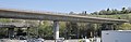
At the Plochinger Dreieck (see photo opposite), the B 313 from the Neckar Valley towards Wendlingen (A 8), Nürtingen and Metzingen is linked with the B 10. It lies directly at the mouth of the Fils in the Neckar and is an imposing structure. In a complex, no longer common construction method, all six directional lanes are guided directly.
District of Göppingen
In Ebersbach / Fils, the B 10 reaches the Göppingen district , which also belongs to the Stuttgart region.
On June 7, 2006, the new, 3.9 km long section with the Eislingen bypass was opened in the district of Göppingen . At the same time, the new federal road near Salach was linked to the old one in the form of a roundabout.
On July 25, 2008, the B 10 junction Göppingen-West was opened at the Öde vocational school center. The B 297 was laid over the Pfingstwasen crossbar, which was completed in 2005 and has a 300 m long bridge, to the new B 10 junction to relieve Faurndau . The construction of this junction began in 2006. The Göppingen-Ost junction was opened on November 17, 2006. This makes it possible again to get from the B 10 directly to Eislingen-Süd as well as to Holzheim without major detours.
The extension of the B 10 to Süßen was completed at the end of 2009, and traffic was opened on December 22nd. The subsequent section to the old B 10 was opened in late summer 2011. From October 2015 until July 2018, the building continued to Gingen-Ost. In addition, the federal highway 466 between Süßen and Gingen was connected to the B 10 in autumn 2016.
Alb-Danube district
On November 14, 2006, the new 2.6 km long Luizhausen bypass (municipality of Lonsee ) was completed in the Alb-Donau district . As an important connection from the Ulm area to the Filstal , the new bypass is of supraregional importance. The federal government has therefore invested 4.7 million euros.
City of Ulm
In the area of the city of Ulm , the B 10 is currently being renovated, whereby the construction work will continue until 2020 according to the city administration. Since summer 2009, the B 10 has been closed to lorry traffic in Ulm. The B 10 was initially not included in the environmental zone of the cities of Ulm and Neu-Ulm. Since January 1, 2013, the B 10 in Ulm between the University exit and the Danube bridge has been part of the environmental zone and can therefore only be used with a green sticker.
The state of Baden-Württemberg will now be left and the road will reach the state of Bavaria after crossing the Danube.
District of Neu-Ulm
In Neu-Ulm , the intersection Memminger Strasse (former B 19 , now State Road 2031) - Europastrasse (B 10) was redesigned from 2006 to 2007. The B 10 now runs under the state road and thus dissolved a large and accident-prone traffic junction that was previously used by more than 30,000 vehicles every day. From mid-April 2012 to mid-June 2014, the intersection Reuttier Strasse / B 10 was also redesigned. Similar to the intersection of Memminger Straße, the B 10 tunnels under, the traffic above the tunnel is now regulated by a roundabout. From July 2018, the last inner-city intersection on Otto-Hahn-Straße will be built without intersections. For this purpose, the B10 will run in 1 lane by means of a bridge over Otto-Hahn-Straße and the intersection below will be converted into a roundabout. In the Federal Transport Infrastructure Plan 2030, an urgent requirement is for the B 10 to be expanded to four lanes in the congested area between Breitenhof and the Nersingen junction ( A 7 ). For this purpose, two lanes are to be built south of the existing route and the junction is to be expanded into a cloverleaf without a traffic light. During the construction of the A 7, the underpass was dimensioned for four lanes and space was reserved for the southern part of the Kleeblatt-Kreuz. In May 2018, the bridge over the B10 near Steinheim was demolished as an advance payment and replaced by a bridge dimensioned for four-lane traffic.
In 2015, the B 10 between the Nersingen junction and the border with the Günzburg district was downgraded to State Road 2509.
The route for relocating the B 10 between Breitenhof and the Neu-Ulm / B 30 motorway triangle will continue to be kept free.
Districts of Günzburg and Augsburg
Due to the six-lane expansion of the parallel A 8 , the B 10 in the districts of Günzburg and Augsburg was completely downgraded.
First, the B 10 ended from January 1, 2011 in Leipheim at the GZ4, then from January 1, 2014 at the Leipheim motorway junction. In 2015, the B 10 was downgraded from the district border near Neu-Ulm to the B 16 to a state road.
On January 1, 2016, the last section in the district between Günzburg and the B 300 near Neusäß was downgraded to the state road St2510. Local thoroughfares became partly municipal roads.

Beginning of the Enzweihinger Steige
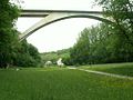
Glemstal Viaduct near Schwieberdingen
“Friedrichswahl” ramp in Stuttgart-Feuerbach
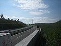
B 10 new building near Eislingen


Truck toll
Since August 1, 2012, the truck toll has been due on the sections from the A 62 to Pirmasens, from the A 65 ( Wörther Kreuz ) to Karlsruhe, from the A 81 to Stuttgart-Zuffenhausen and from Dornstadt to Ulm.
See also
Web links
- Detailed route description of the Filstalautobahn, which was previously planned as Bundesautobahn 80
- Detailed route description of the section near Stuttgart that was previously planned as federal motorway 83
- Detailed route description of the small north-east ring Stuttgart, which was previously planned as federal motorway 87
- Detailed route description of the route section Nersingen - Neu-Ulm, which was previously planned as federal motorway 89
- Detailed route description of the Wörth - Pfinztal section, which was previously planned as the 652 federal motorway
- Conflict over B 10 expansion in the Palatinate ( memento from July 18, 2009 in the web archive archive.today ) and the current BUND Südpfalz website
- Transport policy: The first cars are to roll in the Rosenstein tunnel in 2015 ( memento from September 10, 2012 in the web archive archive.today ) in "stuttgarter-zeitung.de"
- Homepage of the citizens' initiative Geislingen B 10 New
- Webcam B 10 in Ulm, view in north direction to the height of Schwenk Zement / Esso gas station
Individual evidence
- ↑ Augsburger Allgemeine: Adenauer Bridge is ready for demolition
- ↑ routes.wikia.com. Retrieved December 8, 2011 (French).
- ↑ http://www.landkartenarchiv.de/vollbild_deutschlandkarten.php?q=ddac_strassenkarte_deutschland_1940 Landkartenarchiv DDAC Deutschlandkarte 1940
- ↑ a b c At the end of 2016, you should pass the traffic lights. In: Pirmasenser Zeitung No. 253, October 31, 2015.
- ↑ Guido Glöckner: From 2016 four lanes to Hinterweidenthal. Pfälzischer Merkur, June 15, 2010, accessed December 8, 2011 (newspaper article).
- ↑ B 10: Pass Hinterweidenthal without traffic lights. Retrieved June 28, 2016 .
- ↑ B 10 expansion is stuck in planning mode. Pfälzischer Merkur, February 7, 2019, accessed on December 16, 2019 .
- ↑ Animals in Need Gossersweiler eV: "Wildbrücke over the B10"
- ↑ OpenStreetMap
- ↑ photo
- ↑ The planning approval procedure for the extension B 10 has been completed ( Memento from May 18, 2015 in the Internet Archive )
- ↑ Ministry: Mediation for B10 should start in 2012. Rhein-Zeitung, November 16, 2011, accessed on January 11, 2012 .
- ↑ The tug-of-war over the expansion of the B 10th SWR, June 3, 2015, accessed on June 5, 2015 .
- ↑ OVG rejects lawsuits against B10 expansion. SWR, July 1, 2015, accessed on July 4, 2015 .
- ↑ Becht: B 10 expansion is also economic policy. Ministry of Economics, Transport, Agriculture and Viticulture Rhineland-Palatinate, March 25, 2019, accessed on March 29, 2019 .
- ^ Road from Rodalben to Donsieders is no longer there this year. In: Die Rheinpfalz - Pirmasenser Rundschau No. 145, June 26, 2013.
- ↑ Citizens do not see any progress on the B10 construction site . Die Rheinpfalz, July 11, 2018, accessed on October 19, 2018.
- ↑ Federal Transport Infrastructure Plan 2030, draft March 2016 , p. 136 f., Accessed on March 20, 2016.
- ↑ Federal Transport Infrastructure Plan 2030, approved overall plan of August 3, 2016 ( memento of August 3, 2016 in the Internet Archive ), accessed on August 10, 2016.
- ↑ [1] , accessed on December 16, 2019.
- ↑ fis: Verkehr: In the north things are going ahead. Traffic relief for Hagsfeld has priority. StadtZeitung, 2009, accessed on December 8, 2011 (notification from the City of Karlsruhe).
- ↑ mr: Nordtangente is progressing. news-aus-baden.de, September 15, 2009, accessed December 8, 2011 .
- ↑ The dreary gate to the city should be four lanes and greener. ( Memento from September 11, 2012 in the web archive archive.today )
- ↑ B 10 - Expansion of the B 10 between Eutingen and Niefern. (No longer available online.) Karlsruhe Regional Council, archived from the original on October 28, 2013 ; accessed on December 8, 2011 (plan documents).
- ↑ Trees fall for the Rosenstein tunnel. Retrieved March 17, 2014 .
- ^ New building B 10 - Rosenstein tunnel. State capital Stuttgart, civil engineering office with its own municipal drainage system, accessed on March 17, 2014 .
- ↑ Stuttgarter Zeitung, Stuttgart Germany: Friedrichswahl in Stuttgart Zuffenhausen: The access ramp could give way in 2019. Retrieved December 12, 2018 .
- ↑ More relief and quality of life for the people in Zuffenhausen - Demolition of the Friedrichswahl access ramp | Participatory budget Stuttgart. Retrieved December 12, 2018 .
- ↑ Gerhard Schertler: Expansion of the B10 comes to a standstill. Stuttgarter Nachrichten, September 19, 2011, accessed December 8, 2011 (newspaper article).
- ↑ The eastern B 10 tunnel is open to traffic. City of Ulm online, archived from the original on April 13, 2010 ; Retrieved December 8, 2011 .
- ↑ IHK information event on the environmental zone on December 10, 2012 (PDF; 413 kB) Retrieved on April 5, 2013 .
- ↑ Reuttier Straße roundabout opened. Neu-Ulmer Zeitung, accessed on June 16, 2014 .
- ↑ Ariane Attrodt: There will soon be three corners in Neu-Ulm . In: Augsburger Allgemeine . ( augsburger-allgemeine.de [accessed June 26, 2018]).
- ↑ The B 10 in Leipheim becomes a local road. Günzburger Zeitung, accessed on March 29, 2013 .
- ↑ Minutes of the 18th district committee meeting on December 3, 2015, pages 9/10. (PDF) In: Minutes of the meeting. Landratsamt Günzburg, accessed on April 17, 2016 .