
Dornstadt
| coat of arms | Germany map | |
|---|---|---|

|
Coordinates: 48 ° 28 ' N , 9 ° 57' E |
|
| Basic data | ||
| State : | Baden-Württemberg | |
| Administrative region : | Tübingen | |
| County : | Alb-Danube district | |
| Height : | 590 m above sea level NHN | |
| Area : | 59.24 km 2 | |
| Residents: | 8686 (December 31, 2018) | |
| Population density : | 147 inhabitants per km 2 | |
| Postal code : | 89160 | |
| Primaries : | 07348, 07336, 07304 | |
| License plate : | UL | |
| Community key : | 08 4 25 031 | |
| Address of the municipal administration: |
Kirchplatz 2 89160 Dornstadt |
|
| Website : | ||
| Mayor : | Rainer Braig | |
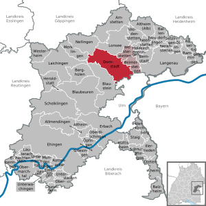
| Location of the municipality of Dornstadt in the Alb-Donau district | ||
  |
||

Dornstadt is a municipality in the Alb-Donau district in the German state of Baden-Württemberg ( Germany ). It is eight kilometers north of Ulm .
geography

Geographical location
Dornstadt is on the southern edge of Swabian Alb situated Ulmer Alb . Dornstadt itself lies at 590 m above sea level, the suburb of Scharenstetten at 707 m above sea level.
Neighboring communities
The municipality borders in the north on Lonsee , in the east on Westerstetten and Beimerstetten , in the south on the city of Ulm , in the south-west on Blaustein , and in the north-west on Merklingen , Laichingen and Nellingen .
history

Until the 19th century
The place was first mentioned in a document in 1225. The common year number 1209 is not confirmed by the Baden-Württemberg State Archives. Until 1465 Dornstadt belonged to the property of the Lorch Monastery and then passed into the possession of the Elchingen Monastery and was subordinate to the Tomerdingen Care Office. On the church side, Dornstadt belonged to the Tormerdinger parish Mariä-Himmelfahrt until 1674 and was then raised to an independent parish. As part of the Reichsdeputationshauptschluss in 1803, the Elchingen monastery lost its land. Dornstadt became temporarily Bavarian until it finally fell to the Kingdom of Württemberg through the border treaty between Bavaria and Württemberg in 1810 and was subordinated to the Blaubeuren Oberamt .
20th and 21st centuries
During the district reform in Württemberg during the Nazi era , Dornstadt became part of the Ulm district in 1938 . In 1945 the place became part of the American zone of occupation and thus belonged to the newly founded state of Württemberg-Baden , which was incorporated into the current state of Baden-Württemberg in 1952. In 1973 the district reform took place in Baden-Württemberg , when Dornstadt became part of the Alb-Donau district.
The community in its current composition was established in the mid-1970s. After the municipality of Bollingen with its district Böttingen had already been incorporated on July 1, 1971, the municipalities of Dornstadt and Tomerdingen merged on January 1, 1975 to form the new municipality of Dornstadt, and the communities of Scharenstetten and Temmenhausen were incorporated into the new municipality.
Today Dornstadt itself is the largest suburb of the entire municipality with around 4400 inhabitants.
Population development
These are population numbers according to the respective territorial status. The numbers are census results (¹) or official updates from the Baden-Württemberg State Statistical Office (only main residences ).
|
|
Districts


Bollingen
 |
Bollingen is located on the edge of the Kiesental and can look back on documented mentions from the 12th century. It currently has around 1100 inhabitants.
There are close ties to the neighboring hamlet of Böttingen . |
Scharenstetten
 |
Scharenstetten has approx. 800 inhabitants and is located on a hill of the Middle Kuppenalb and is visible from a distance mainly through the 28 m high water tower and the 23 m high church tower. The name of the village probably comes from the founder of the village, a Scaro . It was first mentioned in a document in 1260. The Laurentius Church is particularly worth seeing. The nave in its current form is probably only 200 years old, but the church tower with the coupled, double-arched sound windows dates from the 11th century. |
The 14th century frescoes in the choir area were laid down during renovation work in 1958. The pictures of the apostles by the Tomerdingen baroque painter Josef Wannenmacher came to the church in 1767. The altar of the church, which comes from the school of Hans Multscher and was built around 1450, is of particular importance . During the iconoclasm, it was moved from the Ulm Minster , where it originally stood, to an Ulm magazine. In 1760 it was installed in the Laurentius Church because the existing Scharenstetter altar was not in good condition and the Scharenstetter bailiff at the time had asked the Ulm parish church building office for an old altar.
Temmenhausen
 |
Temmenhausen is located directly on the rise from the Mittlere Flachalb to the Mittlere Kuppenalb , the so-called Klifflinie , and thus on the beach of a former sea that dried up a few million years ago.
Temmenhausen is home to a good 600 people. There are two youth clubs for young people, the Temmenhausen container and the Temmenhausen whey . |
Tomerdingen
 |
The largest suburb in terms of area, Tomerdingen, with around 1,800 inhabitants, was already settled during the La Tène period . Settlements have been found in the Church of St. Martin since the Carolingian era .
→ Main article: Tomerdingen |
politics
mayor
- 1964–1991: Manfred Klein
- 1991-2007: Erich Mack
- since 2007: Rainer Braig
In the mayoral election on April 22, 2007, Rainer Braig was elected with 51.4 percent of the vote. He took office on July 1, 2007.
Municipal council
In Dornstadt, the municipal council is elected using the spurious selection of a part of town. The number of local councils can change due to overhang mandates . The municipal council consists of the elected voluntary councilors and the mayor as chairman. The mayor is entitled to vote in the municipal council. The local council in Dornstadt has 23 members after the last election (previously 25). The local election on May 26, 2019 led to the following preliminary final result.
| Parties and constituencies |
% 2019 |
Seats 2019 |
% 2014 |
Seats 2014 |
||
| FW | Free voters | 51.5 | 12 | 46.3 | 11 | |
| CDU / BWV | Christian Democratic Union of Germany / Citizens' Association of Voters | 31.6 | 7th | 34.9 | 9 | |
| SPD | Social Democratic Party of Germany | 16.8 | 4th | 18.9 | 5 | |
| total | 100.0 | 23 | 100.0 | 25th | ||
| voter turnout | 62.7% | 53.3% | ||||
Partnerships
Dornstadt has maintained a partnership with the French Coutras in the Gironde department of the Nouvelle-Aquitaine region since 1989 .
traffic
Dornstadt is located directly on the A 8 Stuttgart - Munich , motorway exit Ulm-West / Dornstadt (exit 62).
The districts of Scharenstetten, Tomerdingen and Temmenhausen are on the Franconian-Swabian Way of St. James , a pilgrimage route that leads to Ulm and on to Spain.
economy
Established businesses
Dornstadt has set up a 40 hectare industrial area called Himmelweiler, an expansion area for companies in the Ulm / Neu-Ulm region . There is also a container terminal , which was opened in November 2005. The favorable traffic situation makes Dornstadt attractive for many companies.
According to information from Deutsche Bahn from March 2016, the station, which is designed for 100,000 handling operations per year, is being operated close to its performance limit. Planning for an expansion of the terminal to the west of the existing facility was in the early stages.
The Shoe House Werdich GmbH & Co. KG is one of 45 specialty shops on the 20 largest retail chains in the German shoe retail trade.
Temmenhausen wind farm
Since the beginning of 2007 between Temmenhausen and Bermaringen five wind turbines the company Vestas in operation. The hub height of the three wind turbines, which are located on the Bermaringen side, is 108 m, that of the two at Temmenhausen 98 m.
military
The Medical Regiment 3 of the Bundeswehr 's Rommel barracks stationed on the Lerchenfeld. During the Second World War there was also the Ulm-Dornstadt Air Base here .
Culture and sights

Regular events
Orchard Festival
Every summer the Obstwiesenfestival takes place in Dornstadt , where numerous, sometimes well-known, live bands perform. Admission is free.
education
At the Bühl school center in Dornstadt there is a primary school , a Werkrealschule , a Realschule, as well as a so-called special educational advisory and education center with a focus on learning , where children with learning difficulties are taught. The community library, the Dornstadt community, is also located at the school center. There, as part of a decentralized adult education center , a joint adult education center that is run together with other municipalities, further training offers for adults take place.
Personalities
Sons and daughters of the church
- Johann Peter Miller (1705–1781), born in Scharenstetten, classical philologist and teacher
- Joseph Wannenmacher (1722–1780) born in Tomerdingen, Swabian baroque painter and fresco artist
- Marlies Kohnle-Gros (* 1956), politician (CDU)
Personalities who are connected with Dornstadt
- Manfred Klein (1936–2012), Mayor of Dornstadt from 1964 to 1991, Member of the State Parliament (CDU)
- Natalija Polonska-Wassylenko (1884–1973), Ukrainian historian, died in Dornstadt and is buried there
literature
- H. Zürn, F. Fischer: The Celtic Viereckschanze of Tomerdingen . In: Materialh. Before u. Mornings Bad-Württ. , 14, Stuttgart 1991.
- Dornstadt . In: Description of the Oberamt Blaubeuren from 1830 ( Wikisource )
Web links
- Dornstadt at LEO-BW
- Website of the municipality of Dornstadt
- Information about the Rommel barracks, the Lerchenfeld training area and the former airfield
Individual evidence
- ↑ State Statistical Office Baden-Württemberg - Population by nationality and gender on December 31, 2018 (CSV file) ( help on this ).
- ↑ Archive link ( Memento of the original from May 20, 2013 in the Internet Archive ) Info: The archive link was inserted automatically and has not yet been checked. Please check the original and archive link according to the instructions and then remove this notice.
- ↑ Official district description of the Alb-Donau-Kreis 1989 publisher Landesarchivdirektion Baden-Württemberg
- ↑ Dornstadt in the description of the Oberamt Blaubeuren and Master Hartmann Dornstadter Altar in writings of the Alb-Donau-Kreis No. 37
- ^ Martin Nestler: Ulm, history of a city .
- ^ Federal Statistical Office (ed.): Historical municipality directory for the Federal Republic of Germany. Name, border and key number changes in municipalities, counties and administrative districts from May 27, 1970 to December 31, 1982 . W. Kohlhammer, Stuttgart / Mainz 1983, ISBN 3-17-003263-1 , p. 457 and 543 .
- ↑ Population development in Baden-Württemberg from 1871 to 2012 ( page no longer available , search in web archives ) Info: The link was automatically marked as defective. Please check the link according to the instructions and then remove this notice.
- ↑ Dornstadt website ( page no longer available , search in web archives ) Info: The link was automatically marked as defective. Please check the link according to the instructions and then remove this notice.
- ↑ Railway needs space for container terminal . In: Südwest Presse . March 15, 2016, p. 27 .
- ^ Bühl school center. Retrieved April 29, 2017 .
- ↑ Adult Education Center. Retrieved April 29, 2017 .

Allmendingen | Altheim | Altheim (Alb) | Amstetten | Asselfingen | Ballendorf | Balzheim | Beimerstetten | Berghulen | Bernstadt | Blue beers | Bluestone | Börslingen | Breitingen | Dietenheim | Dornstadt | Ehingen (Danube) | Emeringen | Emerkingen | Erbach | Griesingen | Grundsheim | Hausen am Bussen | Heraldstatt | Holzkirch | Hüttisheim | Illerkirchberg | Illerrieden | Laichingen | Langenau | Lauterach | Lonsee | Merklingen | Munderkingen | Neenstetten | Nellingen | Nerenstetten | Oberdischingen | Obermarchtal | Upper Stadium | Öllingen | Öpfingen | Rammingen | Rechtenstein | Rottenacker | Schelblades | Lace-ups | Setzingen | Staig | Untermarchtal | Lower Stadium | Unterwachingen | Weidenstetten | Westerheim | Westerstetten