
Emerkingen
| coat of arms | Germany map | |
|---|---|---|

|
Coordinates: 48 ° 13 ' N , 9 ° 39' E |
|
| Basic data | ||
| State : | Baden-Württemberg | |
| Administrative region : | Tübingen | |
| County : | Alb-Danube district | |
| Height : | 531 m above sea level NHN | |
| Area : | 7.4 km 2 | |
| Residents: | 848 (December 31, 2018) | |
| Population density : | 115 inhabitants per km 2 | |
| Postal code : | 89607 | |
| Area code : | 07393 | |
| License plate : | UL | |
| Community key : | 08 4 25 036 | |
| Address of the municipal administration: |
Schlossstrasse 23 89607 Emerkingen |
|
| Website : | ||
| Mayor : | Paul Burger | |
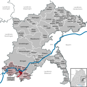
| Location of the community Emerkingen in the Alb-Donau district | ||
  |
||


Emerkingen is a municipality in the Alb-Donau district in Baden-Württemberg . She belongs to the administrative community Munderkingen .
geography
Emerkingen is located on a hill on the southern edge of the Danube Valley , about 35 km southwest of Ulm .
Neighboring communities
The community borders the city of Munderkingen in the north, Unterstadion in the east, Oberstadion and Unterwachingen in the south and Hausen am Bussen in the west . (all Alb-Danube district ).
history
Until the 19th century
In Roman times there was a cohort fort and its vicus in the area of today's municipality . The fort was located about 600 meters north-northwest of the later town. It was built around 45 AD, was probably strengthened and expanded after the turmoil of 69 AD and existed until around 85 AD. North and west of this camp was a village (vicus), whose Latin name is unknown and that lasted much longer than the camp. A brick factory was also operated here from the middle of the 1st to the middle of the 2nd century AD . See also the separate article Kastell Emerkingen .
About half a kilometer south of it, at the location in the center of Emerkingen, an Alemannic settlement later developed, as evidenced by a Merovingian burial ground. As early as 805, Emerkingen was first mentioned in the Latinized form "in Antarmarhingas" in a deed of donation from Counts Chadaloh I and Wago to the St. Gallen monastery . The oldest tangible, Old High German form of the name of the place was Antarmarchingan or Antarmarkingan .
The village gave its name to the Barons von Emerkingen, whose medieval castle was demolished in 1870 except for the so-called "Roman Tower" .
20th century
In the First World War , 20 Emerkingers lost their lives, and in 1922 a war memorial was created. 22 Emerkingers fell in World War II , 13 went missing. Land consolidation took place from 1949 to 1952, and the war memorial was redesigned in 1961. In 1971 Emerkingen had around 600 inhabitants, and since January 1, 1973 it has belonged to the Ulm district (previously Ehingen). In 2005 the 1200th anniversary was celebrated.
Religions
On July 7, 1103, the castle chapel was the first church in town to be consecrated. Emerkingen has been the seat of a Catholic parish office since May 3, 1900, previously the parish was parish in Unterwachingen .
Municipal council
The community council in Emerkingen has eight members. It consists of the voluntary councilors and the mayor as chairman. The mayor is entitled to vote in the municipal council. In the local elections on May 26, 2019 , the local council was elected by majority vote. Majority voting takes place if no or only one nomination has been submitted. The applicants with the highest number of votes are then elected. The turnout was 72.3% (2014: 72.5%).
Economy and Infrastructure
A commercial area was developed on the Brühlwiesen .
Museums
The local history museum is located in the Roman tower .
Web links
Individual evidence
- ↑ State Statistical Office Baden-Württemberg - Population by nationality and gender on December 31, 2018 (CSV file) ( help on this ).

Allmendingen | Altheim | Altheim (Alb) | Amstetten | Asselfingen | Ballendorf | Balzheim | Beimerstetten | Berghulen | Bernstadt | Blue beers | Bluestone | Börslingen | Breitingen | Dietenheim | Dornstadt | Ehingen (Danube) | Emeringen | Emerkingen | Erbach | Griesingen | Grundsheim | Hausen am Bussen | Heraldstatt | Holzkirch | Hüttisheim | Illerkirchberg | Illerrieden | Laichingen | Langenau | Lauterach | Lonsee | Merklingen | Munderkingen | Neenstetten | Nellingen | Nerenstetten | Oberdischingen | Obermarchtal | Upper Stadium | Öllingen | Öpfingen | Rammingen | Rechtenstein | Rottenacker | Schelblades | Lace-ups | Setzingen | Staig | Untermarchtal | Lower Stadium | Unterwachingen | Weidenstetten | Westerheim | Westerstetten