
Griesingen
| coat of arms | Germany map | |
|---|---|---|

|
Coordinates: 48 ° 16 ' N , 9 ° 47' E |
|
| Basic data | ||
| State : | Baden-Württemberg | |
| Administrative region : | Tübingen | |
| County : | Alb-Danube district | |
| Height : | 506 m above sea level NHN | |
| Area : | 8.16 km 2 | |
| Residents: | 1039 (December 31, 2018) | |
| Population density : | 127 inhabitants per km 2 | |
| Postal code : | 89608 | |
| Area code : | 07391 | |
| License plate : | UL | |
| Community key : | 08 4 25 050 | |
| LOCODE : | DE GWG | |
| Address of the municipal administration: |
Alte Landstrasse 51 89608 Griesingen |
|
| Website : | ||
| Mayor : | Oliver Klumpp | |
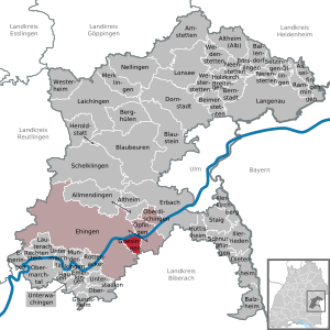
| Location of the community of Griesingen in the Alb-Donau district | ||
  |
||

Griesingen is a municipality in the Alb-Donau district in Baden-Württemberg ( Germany ).

geography
location
Griesingen is located on the Danube about 25 kilometers upstream from Ulm .
Neighboring communities
The community borders in the east on Öpfingen , in the south on the city of Laupheim in the district of Biberach and is otherwise surrounded by the area of the city of Ehingen .
Field names
"Field names are the names of mountains and valleys, forests and fields, streams and ponds, paths and footbridges and other uninhabited areas outside of settlements. They contain, often handed down over many centuries, old - often foreign - language and allow conclusions to be drawn settlement history. Field names are therefore important sources of regional history. " (Source: Heimatbund Thuringia)
Some field names are old, but still in lively use, others have become history and are only known to a few people. They tell something about the life and work of the local people - how they earned their living, what they had to struggle with, where they celebrated their parties and where they celebrate today.
At the Griesing Forest
The parcel is located at the edge of the forest in the extension of the forest road, past Käppele, up the mountain along the edge of the forest, past the Bildstöckle. The parcel is about halfway between the Käppele and the corner of the forest, to the south. Neighboring: Bibellüß, Greut, Hinter dem Berg, Blößäcker (partly marked Schaiblishausen). The community of Griesingen owns two small forest parcels in the Taxis forest. However, these are located in the south-eastern marking area at the parcels "Unteres Greut" and "Eichenwäldle", far from the corridor "Am Griesinger Wald". The name “Am Griesinger Wald” cannot refer to communal ownership, but to the location of this large forest area, which is located near Griesingen and to a large extent also on Griesinger Markung. In neighboring towns, too, people speak of the "Griesinger Forest". The parcel “must have been cleared and distributed to the farmers in the 18th century.” (C. Kohl) - See also “Am Nasgenstadter See” under the corridor below.
At the Nasgenstadter See
Today the parcel is probably on the Nasgenstadt mark. However, it is no longer entered on land maps. But it stands to reason that it was reflected in the Nasgenstadt field names Wasserstall, Hirtensee and “Krummer See”. After the Thirty Years War (1618–48), additional areas were made arable through the deliberate influx of farmers (see “Stockäcker”). Also in Ösch, which is located in Nasgenstadt, new field names were created at the same time - on the former Griesinger mark: Am Nasgenstadter See, Brühl, Halden, Pfaffental, Im See (Krummer See), Untere Au.
Old pasture parts
Almost on the south-eastern boundary of the marker (Riississen zu), on the edge of the forest. Neighboring: Forch parts, footbridge, lower street parts. Parts are mostly small pieces from the commons. Common land is the name of the agricultural land jointly managed by the village community. The right of use was raffled. Therefore one also said loose parts or common parts. After their use, there were also parts of cattle, beetroot, etc. in addition to cattle parts aspired to the community. Such requests were carefully examined at the mayor's office (municipal administration). So that a new citizen of the community would probably not be a burden, he had to prove his reputation (something like a police clearance certificate) and his financial position by means of certificates. A citizenship fee had to be paid for the citizenship granted. Often there were also obligations, for example to buy a fire bucket to fight fires in the community. (...) A resident who was not a citizen of the community was not entitled to the privileges of a citizen such as social help, common land use, free school attendance. If a citizen was in arrears with fees or taxes for the community, he was threatened with the withdrawal of citizenship. "(Wohlleb, Altsteußlingen)
history
Religions
The population of Griesingen is predominantly Roman Catholic. The parish is the seat of the parish of St. Leodegar, which belongs to the deanery Ehingen-Ulm.
politics
Municipal council
The municipal council in Griesingen has ten members. It consists of the voluntary councilors and the mayor as chairman. The mayor is entitled to vote in the municipal council. In the local elections on May 26, 2019 , the local council was elected by majority vote. Majority voting takes place if no or only one nomination has been submitted. The applicants with the highest number of votes are then elected. The turnout was 68.3% (2014: 68.3%).
mayor
The mayor is elected for eight years according to the Baden-Württemberg municipal code.
- 1997–2014: Ulrich Oberdorfer
- In February 2014, the professional soldier Oliver Klumpp (independent) was elected as the new mayor with 55.8% of the vote.
Culture
The Musikverein Griesingen eV, which was founded in 1958, currently has around 50 musicians in the main band. Under the direction of Andreas Braig, the music association takes part in a number of appearances at various events but also at festive occasions in the community. A particular highlight in the club's history was participation in the Steuben Parade in New York and the subsequent 14-day concert tour in the United States of America in September 1977.
Economy and Infrastructure
In addition to small businesses, Griesingen also has a specialist medical publisher and a press agency for medicine.
education
Griesingen has its own primary school and a kindergarten run by the Catholic Church. Attending secondary schools is only possible in neighboring communities.
Individual evidence
- ↑ State Statistical Office Baden-Württemberg - Population by nationality and gender on December 31, 2018 (CSV file) ( help on this ).
Web links

Allmendingen | Altheim | Altheim (Alb) | Amstetten | Asselfingen | Ballendorf | Balzheim | Beimerstetten | Berghulen | Bernstadt | Blue beers | Bluestone | Börslingen | Breitingen | Dietenheim | Dornstadt | Ehingen (Danube) | Emeringen | Emerkingen | Erbach | Griesingen | Grundsheim | Hausen am Bussen | Heraldstatt | Holzkirch | Hüttisheim | Illerkirchberg | Illerrieden | Laichingen | Langenau | Lauterach | Lonsee | Merklingen | Munderkingen | Neenstetten | Nellingen | Nerenstetten | Oberdischingen | Obermarchtal | Upper Stadium | Öllingen | Öpfingen | Rammingen | Rechtenstein | Rottenacker | Schelblades | Lace-ups | Setzingen | Staig | Untermarchtal | Lower Stadium | Unterwachingen | Weidenstetten | Westerheim | Westerstetten