
Illerrieden
| coat of arms | Germany map | |
|---|---|---|

|
Coordinates: 48 ° 16 ' N , 10 ° 3' E |
|
| Basic data | ||
| State : | Baden-Württemberg | |
| Administrative region : | Tübingen | |
| County : | Alb-Danube district | |
| Height : | 492 m above sea level NHN | |
| Area : | 18.17 km 2 | |
| Residents: | 3323 (December 31, 2018) | |
| Population density : | 183 inhabitants per km 2 | |
| Postal code : | 89186 | |
| Area code : | 07306 | |
| License plate : | UL | |
| Community key : | 08 4 25 066 | |
| LOCODE : | DE IDN | |
| Address of the municipal administration: |
Wochenauer Strasse 1 89186 Illerrieden |
|
| Website : | ||
| Mayor : | Jens Kaiser | |
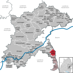
| Location of the community of Illerrieden in the Alb-Donau district | ||
  |
||


Illerrieden is a municipality in the Alb-Danube district in Baden-Württemberg .
geography
location
The community of Illerrieden is about 15 kilometers south of Ulm and about 42 kilometers north of Memmingen an der Iller . From a regional planning point of view, it belongs to the Danube-Iller region and naturally Central Swabia .
Neighboring communities
Illerrieden borders in the north on Illerkirchberg (Oberkirchberg) , in the east on Vöhringen , in the south on Regglisweiler (city of Dietenheim ) and in the west on Schnürpflingen and Staig .
Districts
In addition to the center, the two districts of Wangen and Dorndorf belong to Illerrieden.
history
Illerrieden
Illerrieden was first mentioned in a document in 1291. From 1568 to 1806 it was under the Teutonic Knight Order and was an exclave of the Teutonic Knights Coming Altshausen within the Teutonic Knights Ballei Swabia-Alsace-Burgundy . By the Rhine Federation Act of July 12, 1806, the place came to the Kingdom of Württemberg . Today's community was formed on March 1, 1972 by the union of the communities Illerrieden and Wangen. On January 1, 1971, Dorndorf was incorporated into Illerrieden.
Districts
Dorndorf
.png)
Cheeks
.png)

politics
mayor
| Term of office | Surname |
|---|---|
| 1849-1850 | Lorenz Hueter |
| 1850-1894 | Remigius Vogt |
| 1894-1919 | Karl Nothelfer |
| 1919 | Joseph Helper |
| 1920-1945 | Nikolaus Stocker |
| 1945–1966 | Johannes Mock |
| 1966-2004 | Franz Geisinger |
| since 2004 | Jens Kaiser |
Community partnerships
There has been a partnership with Guignicourt since 1986 , since January 1, 2019 in the Commune nouvelle Villeneuve-sur-Aisne , in the French department of Aisne .
Attractions
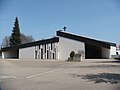
- St. Agatha Catholic Church in Illerrieden
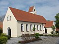
- Catholic Holy Cross Church in Illerrieden
- Catholic Church of St. Trinity in Dorndorf
- Catholic branch chapel for St. Wendelinus in Wangen

The Church of St. Agatha in Illerrieden
The Holy Cross Church in Illerrieden
Church of St. Trinity in the Dorndorf district

The Wendelinus Chapel in the Wangen district


Sports
Sportfreunde Illerrieden 1926 eV, which mainly consists of the football, athletics, gymnastics and gymnastics departments, was founded in 1926 as FV Sportfreunde Illerrieden and was initially a pure football club. The club plays its home games in the Iller Stadium in Illerrieden, which offers around 1000 standing places.
education
Illerrieden has its own elementary and community school . Realschule and grammar school can be attended in Vöhringen . There is also a kindergarten on site.
Personalities
Honorary citizen
- Spiritual advice Pastor Hans König
- Mayor a. D. Franz Geisinger
Born in the place
- Heinrich Suso Brechte (1910–1975), Missionary Benedictine, Archabbot of St. Ottilien 1957–1974
literature
- Ferdinand Eggmann: The history of the Illertal . Ulm 1862 ( digitized version )
Web links
Individual evidence
- ↑ State Statistical Office Baden-Württemberg - Population by nationality and gender on December 31, 2018 (CSV file) ( help on this ).
- ^ Federal Statistical Office (ed.): Historical municipality directory for the Federal Republic of Germany. Name, border and key number changes in municipalities, counties and administrative districts from May 27, 1970 to December 31, 1982 . W. Kohlhammer, Stuttgart / Mainz 1983, ISBN 3-17-003263-1 , p. 457 .
- ↑ Uwe Schmidt Beate Sauerbrey: In the course of history Dorndorf Illerrieden Wangen . Süddeutsche Verlagsgesellschaft, Ulm 2004, p. 134 .

Allmendingen | Altheim | Altheim (Alb) | Amstetten | Asselfingen | Ballendorf | Balzheim | Beimerstetten | Berghulen | Bernstadt | Blue beers | Bluestone | Börslingen | Breitingen | Dietenheim | Dornstadt | Ehingen (Danube) | Emeringen | Emerkingen | Erbach | Griesingen | Grundsheim | Hausen am Bussen | Heraldstatt | Holzkirch | Hüttisheim | Illerkirchberg | Illerrieden | Laichingen | Langenau | Lauterach | Lonsee | Merklingen | Munderkingen | Neenstetten | Nellingen | Nerenstetten | Oberdischingen | Obermarchtal | Upper Stadium | Öllingen | Öpfingen | Rammingen | Rechtenstein | Rottenacker | Schelblades | Lace-ups | Setzingen | Staig | Untermarchtal | Lower Stadium | Unterwachingen | Weidenstetten | Westerheim | Westerstetten