Holzkirch
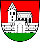
| coat of arms | Germany map | |
|---|---|---|

|
Coordinates: 48 ° 32 ' N , 10 ° 0' E |
|
| Basic data | ||
| State : | Baden-Württemberg | |
| Administrative region : | Tübingen | |
| County : | Alb-Danube district | |
| Height : | 579 m above sea level NHN | |
| Area : | 8.14 km 2 | |
| Residents: | 275 (Dec. 31, 2018) | |
| Population density : | 34 inhabitants per km 2 | |
| Postal code : | 89183 | |
| Primaries : | 07340-919010 | |
| License plate : | UL | |
| Community key : | 08 4 25 062 | |
| Address of the municipal administration: |
Hauptstrasse 8 89183 Holzkirch |
|
| Website : | ||
| Mayor : | Paul Seybold | |
| Location of the municipality of Holzkirch in the Alb-Donau district | ||
Holzkirch is a small municipality in the Alb-Donau district in Baden-Württemberg , Germany . The community belongs to the Langenau community administration association.
geography
Holzkirch is located on the southern edge of the Swabian Alb, north of the Lone Valley and north of Ulm .
Neighboring communities
The community borders in the north on Weidenstetten , in the east on Neenstetten , in the southeast on Bernstadt , in the south on Breitingen and in the west on Westerstetten .
history
Holzkirch was first mentioned in a document in 1362 and came into the possession of the Free Imperial City of Ulm in 1385 . When Ulm lost its status in 1803, the place came with Ulm to Bavaria . The border between Bavaria and Württemberg was finally determined in a treaty in 1810 and Holzkirch became part of Württemberg.
Municipal council
The municipality council in Holzkirch has eight members. In the local elections on May 26, 2019 , the local council was elected by majority vote. Majority voting takes place if no or only one nomination has been submitted. The applicants with the highest number of votes are then elected. The municipal council consists of the voluntary councilors and the mayor as chairman. The mayor is entitled to vote in the municipal council.
mayor
Paul Seybold was elected as the new mayor in 2010. He replaced Gerhard Lindner, who left office after 20 years.
Attractions
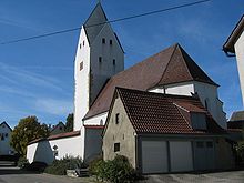
The late Romanesque defense tower of the Barbara Church from around 1150 offered the entire village population protection in troubled times. The very massive churchyard wall also served more as a defense.
Web links
Individual evidence
- ↑ State Statistical Office Baden-Württemberg - Population by nationality and gender on December 31, 2018 (CSV file) ( help on this ).


