
Ollingen
| coat of arms | Germany map | |
|---|---|---|

|
Coordinates: 48 ° 32 ' N , 10 ° 9' E |
|
| Basic data | ||
| State : | Baden-Württemberg | |
| Administrative region : | Tübingen | |
| County : | Alb-Danube district | |
| Height : | 526 m above sea level NHN | |
| Area : | 8.09 km 2 | |
| Residents: | 537 (December 31, 2018) | |
| Population density : | 66 inhabitants per km 2 | |
| Postal code : | 89129 | |
| Area code : | 07345 | |
| License plate : | UL | |
| Community key : | 08 4 25 092 | |
| Address of the municipal administration: |
Hauptstrasse 42 89129 Öllingen |
|
| Website : | ||
| Mayor : | Georg Göggelmann | |
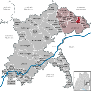
| Location of the municipality of Öllingen in the Alb-Donau district | ||
  |
||

Öllingen is a small community in the Alb-Donau district in Baden-Württemberg . It belongs to the Langenau community administration association.
geography
Geographical location
Öllingen is located on the southern slope of the Swabian Alb , in the northern Alb-Danube district, about 18 km northeast of Ulm . Öllingen is located at 526 m above sea level between the Lonetal in the north and the Danube lowland with the Langenau basin in the south.
General
Located on the southern slope of the surface alb to the Langenauer basin, Öllingen is a rural structured village that was characterized by agriculture, weaving and the mining of sand on the nearby Sandberg. Over the past few decades the village has transformed into a residential community with a few farms and craft businesses. The most striking landmarks of the community are the Ulrichskirche, which can be seen from afar, and the water tower. The district of the municipality covers an area of 809 hectares. With 531 inhabitants (as of December 31, 2012), Öllingen is one of the 30 smallest independent municipalities in Baden-Württemberg.
Neighboring communities
The community borders in the north on the district of Bissingen in the city of Herbrechtingen in the district of Heidenheim , in the east on Rammingen , in the south on the city of Langenau and in the west on Nerenstetten and Setzingen .
history
Öllingen was first mentioned in 1143 under the name Elingen, later Ellingen, and belonged to the Anhausen monastery.
Excavations in 2002 proved that there was a settlement on the Sandberg as early as 2000 BC. In addition, the Bockstein Cave in the Lone Valley was used by Stone Age hunters.
In the 13th century, Öllingen belonged to the Albeck lordship and was sold to Ulm together with Albeck in 1383. The parish's land was sold to the imperial city of Ulm in the 14th century, which led to the imperial city being almost the sole landlord around 1790. Until 1786, the riding post from Oberelchingen made its way through Öllingen to Giengen and Nördlingen.
In 1803 the state affiliation was transferred to the Electorate of Bavaria . In 1810, Öllingen came under a border treaty to the Kingdom of Württemberg , which Öllingen assigned to the Oberamt Albeck . With the dissolution of the Oberamt Albeck in 1819, the Oberamt was merged with the Oberamt Ulm . In 1934 the Oberamt Ulm became the district of Ulm and in 1938 the district of Ulm . The community remained part of the district until 1973. The community reform in 1973 led to the dissolution of the district of Ulm and Öllingen came as an independent community to the Alb-Donau district.
Population development
- 1834: 359
- 1871: 390
- 1895: 373
- 1910: 391
- 1950: 449
- 1970: 383
- 1987: 397
mayor
After the death of Alexander Buchele, Georg Göggelmann was elected as the new mayor in July 2012.
coat of arms

On a red background there is an erect silver (white) lion holding a silver (white) high cross in its front paws. The silver lion on a red background is derived from the coat of arms of Count von Dillingen. In 1143 they handed over the local Fronhof and a quarter of the local church to the Anhausen Monastery on the Brenz . The cross that the lion carries in his paws indicates the relationship to the Anhausen monastery. At the same time, it is seen as a reference to historical relationships with the Wiesensteig monastery. Emperor Ludwig IV. (HRR) Bayer had given him the patronage of the Öllinger Church in 1330. The coat of arms was given to the municipality by the state government on February 21, 1955, the flag by the district office on October 1, 1984.
Sons and daughters of the church
- Georg Hiller (* 1946), local politician, mayor of Blaubeuren 1978–2002, honorary citizen of Blaubeuren
Web links
Individual evidence
- ↑ State Statistical Office Baden-Württemberg - Population by nationality and gender on December 31, 2018 (CSV file) ( help on this ).
- ↑ http://www.oellingen.de/gemeinde/geschichte.php
- ↑ http://www.swp.de/ulm/lokales/alb_donau/goeggelmann-ist-neuer-oellinger-buergermeister-9525576.html

Allmendingen | Altheim | Altheim (Alb) | Amstetten | Asselfingen | Ballendorf | Balzheim | Beimerstetten | Berghulen | Bernstadt | Blue beers | Bluestone | Börslingen | Breitingen | Dietenheim | Dornstadt | Ehingen (Danube) | Emeringen | Emerkingen | Erbach | Griesingen | Grundsheim | Hausen am Bussen | Heraldstatt | Holzkirch | Hüttisheim | Illerkirchberg | Illerrieden | Laichingen | Langenau | Lauterach | Lonsee | Merklingen | Munderkingen | Neenstetten | Nellingen | Nerenstetten | Oberdischingen | Obermarchtal | Upper Stadium | Öllingen | Öpfingen | Rammingen | Rechtenstein | Rottenacker | Schelblades | Lace-ups | Setzingen | Staig | Untermarchtal | Lower Stadium | Unterwachingen | Weidenstetten | Westerheim | Westerstetten